Friday, September 30, 2022

 Seasonal Rainfall 

Maharashtra & Goa coastal seasonal rainfall total 2022:


*


Lanja: 4398*

Malvan: 3271

Devgad: 2570*

Ratnagiri: 2779*

Vengurla:2699*

Shrivardhan: 2858*

Guhagar: 2755*

Pawas: 2267*

Jaitapur:2467*

Harnai: 2515*

Dapoli:3512*

Palghar:3301*

Alibag: 2128*

Murud: 2226*

Chiplun: 3472*

Dadar West:2785*

Vasai:2851*

Colaba: 2094*

Dahanu: 2638*

Thane: 3092*

Kalyan:3350*

Mangaon: 3096*

Santacruz: 2658*

Mahad: 3185*

Pen: 3492*

Roha: 3271*

Uran: 2581*

Boisar: 2309*

Poladpur: 3555*

Nagothane: NA

Ulhasnagar:3387*

Panvel: 3030*


Goa entire:

Quepem:3033*

Pernem:3437*

Mormugao:2241*

Canacona:2907*

Panaji: 2304*

Sanguem:3057*

Sanquelim:2613*


Thursday, September 29, 2022

29th September

South West Monsoon Withdraws from Punjab, Haryana, Delhi and Rajasthan, exactly on 29th ( indicated few days ago in Vagaries). {also confirmed by IMD today}

The withdrawal Line 👇


The Mentioned BB-14 is positioned as shown below 👇, will emerge in the Bay around 1st,and later will merge with the UAC...


Mumbai/Pune: Thunder Showers expected this weekend..30thSept/1st Oct/2nd Oct.

Tuesday, September 27, 2022

27th September Night:

The UAC ( shown in 25th post Image), will on September 28,  be over parts of West Bengal, Odisha, and some parts of North Coastal Andhra Pradesh and  partly over sea. It will almost be over the same region and not show much movement.

Cotinuing from our Snippet shown here..👉

A Typhoon, Noru, has already formed over the South China Sea and will weaken as it crosses the southeast Asian countries of Laos, Thailand, Vietnam, Cambodia etc. Thereafter, it will emerge in the Indian waters, almost merging with this UAC.

NORU 👉 

Hence, on October 2nd/3rd, another system , BB-14  emerge in the Bay. 

As it is now the Withdrawal time, and 200 hp Streams and anti Cyclones resistances are present, BB-14, the systems from the Bay,  will  not reach out far too Westwards. May just track N/NW, into East Indian States .


SWM withdraws from Rajasthan, Punjab, Haryana and Delhi as targeted on 29th.


Mumbai: As already forecasted, we saw almost rain free days, and totally rainfree evenings on 26th and 27th, adding delight to the celebrations...A little hassle from 29th- 1st October ,as Mumbai can see thundershowers in the evenings, and play spoilsport.

Pune will witness showers on 28th,29th and 30th in the evenings.

Bharuch/Surat  will see light rains on 28th, 29th and 30th. May not spoil the festivities.

Sunday, September 25, 2022

25th September Evening Post:

South West Monsoon likely to bid goodbye from Punjab, Haryana, Delhi and Rajasthan by Thursday 29th/ Friday 30th September.

Now, rain activities will reduce significantly over Northwest India including Punjab Haryana Delhi and western parts of Uttar Pradesh. 

An anticyclone is expected to develop over southwest Rajasthan by September 27, and northwesterly dry winds will commence over most parts of Northwest and Central India.

Seasonal Rainfall (in mm) since 01 June 2022 till 25 September 2022 EAST & NORTHEAST INDIA  -17% ,  

NORTHWEST INDIA  +1% 

CENTRAL INDIA +19% 

SOUTH PENINSULA INDIA  +24% 

COUNTRY AS A WHOLE 909.3 mms (Actual) .. 848.5mms ( Normal) +7%

Currently, the Country as a whole is in Surplus by +7%.   

But N.E, Jharkhand and U.P.are in deficit. These states can recover if the UAC in West Bay tracks N/NW...
IMD
------------------------------------------------------------------------------------------------------------------------------

Navratri Forecasts for first 5 days: 

Mumbai: From 26th thru 29th,. Celebrating Navratri Garba will be .with few showers in certain areas, but hopefully without major rain interruptions and without hindrance.

30th onwards, will review if thundershowers can occur. 

Pune: Pune can get the evening thunderstorms from 27th or 28th thru the week. 

Aurangabad District. From 27th/28th/29th, can get moderate to heavy thundershowers in pockets. Some patches may see hit or miss. Thundershowers can occur thru till Friday.

औरंगाबाद जिल्हा. 27/28/29 पासून, अनेक ठिकाणी मध्यम ते जोरदार पाऊस पडू शकतो. शुक्रवारपर्यंत मेघगर्जनेसह पाऊस पडू शकतो.

Gujarat: The first 5 days of Navratri  Celebrations  will be rain free in Saurashtra.

However,  some patchy showers can be expected in Gujarat Region. Bharuch, Surat on 27th,/28th.

Saturday, September 24, 2022

Heavy rain forecast for north India - next 24-48 hours


Uttarakhand, Himachal Pradesh and northern parts of Punjab and Haryana can receive heavy rain in next 24-48 hours. Some places can get very heavy rain. Higher elevations to receive snow.

Chances of landslides and mudslides in Himalayas, take precautions if traveling.


Haryana 24 hour rain: Narnaul 196 mms, Karnal 153 mmRewari 104.4 mm, Gurgain 84 mms, Rohtak 73 mms, Hissar 41 mms.

Friday, September 23, 2022

 23rd September:

Heavy to Moderate Rainfall occurred in Delhi NCR and Haryana...isolated spot in West U.P....Interaction of BB13 (UAC) and Axis of Monsoon

Rainfall 👇


Gurgaon 108 mms, 


Rainfall will decrease by Saturday...This is Last spell of SWM, before withdrawal.

Thursday, September 22, 2022

 Thursday 22nd Night 

Moderate rains in Delhi on Thursday 22nd...Gurugram recorded 93 mms till Night.. 

Final spell before  Monsoon Withdrawal...

Rainfall to continue in parts of NCR, east Rajasthan, west MP over next 2-3 days. Uttarakhand and Himachal Pradesh to receive moderate rain/thundershowers, with the upper reaches getting some snowfall.


 22nd September 

Particular situation along Mumbai Coast ..No trough, no vortex, no system..pull effect of BB 13 not seen


Wednesday, September 21, 2022

 21st September


Cool and Pleasant Weather along Mumbai Area last 3/4 days...Due to 

A Stationary Front block...

Fronts refer to the boundaries between air masses, which are large, discrete atmospheric bodies of unified weather characteristics. If a cold or warm front halts, it becomes a so-called stationary front.

See the weak flow off the Mumbai coast in the Wednesday lower winds Image

Stationary Front Basics

A stationary front is an unmoving one, at least near Earth’s surface. Neither abutting air mass has the power to shove through the other. Such a front may form when upper-level winds that had previously propelled a front along shift and flow parallel to it, or where air masses equally matched stall one another’s movements. Even though the surficial front may be basically stable, air may be significantly moving about higher up in the atmosphere. A stationary front can eventually dissipate, or, given a shift in upper-level winds or the relative strength of one or another of the air masses, might resume mobility as a cold or warm front.

Typical Weather

The exact weather of a stationary front depends greatly on the characteristics of its constituent air masses -- their moisture levels, for example -- and the general instability of the local atmosphere. Often, however, conditions resemble those encountered along warm front weather: extensive cloudiness and showers. As a stationary front can be durable, such overcast and moderate precipitation may persist for days. 👇


Monday, September 19, 2022

Surprised at the current Mumbai Drizzles ?..there is a reason to be...This could happen more in winter, after a front...Vagaries of the Weather...not any trough, Low or Vortex !

Aside the normal conditions, we got surprise drizzles of various intensity in Mumbai,contrary to expectation, formed due to the extensive humidity contains in the regional atmosphere...

Drizzle is a light liquid precipitation consisting of liquid water drops smaller than those of rain – generally smaller than 0.5 mm (0.02 in) in diameter. Drizzle is normally produced by low stratiform clouds and stratocumulus clouds.

Stratiform cloud may form during a warm front passage due to the steady, continuous rain falling from nimbostratus cloud, adding substantial amounts of humidity to the air

Stratiform precipitation, in general, is relatively continuous and uniform in intensity (i.e., steady rain versus rain showers).

Shallow, stable, non-precipitating cloud. Differs from stratus in that it is broken. Stratocumulus often results from PBL(planetary boundary layer (PBL), also called atmospheric boundary layer, the region of the lower troposphere where Earth's surface strongly influences temperature, moisture, and wind through the turbulent transfer of air mass. The height of the PBL ranges from 100 to 3000 m and varies with time, location, and weather conditions-)based cumulus, that encounters a stable layer and is forced to spread laterally.


Statiform/Cumulus Clouds

Drizzle is a light liquid precipitation consisting of liquid water drops smaller than those of rain – generally smaller than 0.5 mm (0.02 in) in diameter. Drizzle is normally produced by low stratiform clouds and stratocumulus clouds.

Sunday, September 18, 2022

18th September...

The Withdrawal of the South West Monsoon has commenced from NW India...18th September. ( Normal Date 17th September).

Step by step, We at Vagaries have been following the withdrawal process from the 14th..and re-iterated on the 16th the progress of withdrawal.

The Images below of Water Vapour, are clearly indicating the same.

Withdrawal line


The 5th dry day completes the formality.

Past week weather of AGROMET observatory at SRIGANGANAGAR (00044)

Date11-09-202212-09-202213-09-202214-09-202215-09-202216-09-2022Total/Avg.
Rain (mm)0.027.00.00.00.00.027

Past week weather of AWS observatory at (A0A7E122)

Date12-09-202213-09-202214-09-202215-09-202216-09-202217-09-2022Total / Average
Rain (mm)0.00.00.00.00.00.00

Past week weather of AGROMET observatory at Bikaner(FSIL) (42164)

Date11-09-202212-09-202213-09-202214-09-202215-09-202216-09-202217-09-2022Total/Avg.
Rain (mm)0.00.00.00.00.00.00.00


----------------------------------------------------------------------------------------------------------------------------

 Now, towards the Monsoon Regions. BB=13 ..

The above Mentioned Regions, in the Image,  will get rains from 19th _ 23rd .

Vidharbh & Marathwada ( Aurangabad) will get the effects from 19th to 23rd also. .Alongwith North Madhya Maharashta.

Jalgaon gets showers from 201th to 23rd..And moderate on 22nd/23rd..cumulative 35-40 mms.

Bhopal also gets showers from 20th to 23rd, and fairly heavy on 22/23.

-----------------------------------------------------------------------------------

No meaningful heavy effect in Konkan & Goa.

Forecast for Monday 19th to Thursday 22nd September.

Mumbai: Mon 19th to Thursday 22nd: Rains decreasing from Sunday Night onwards...then next 4 days, Partly Cloudy with sunny periods. Few passing showers..Warm days at 31c.

Pune: Partly cloudy. Light rain in parts, and warmer days. Pleasant at night (19/20c)

Gujarat will be dry in most regions. Light rainfall in South Gujarat coast (Surat/Valsad) .

Hotter days in New Delhi with SWM withdrawing...days rising to around 37/38c.

औरंगाबाद जिल्ह्यात पुढील २/३ दिवस मध्यम स्वरूपाचा पाऊस.


 Withdrawal of SWM Commences..Update Here at 8 pm IST

Sunday 18th

MMR and nearby region rainfall till 8:30am on 18th September, 2022(in mm):


1. Borivali:108

2. Dahisar:103

3. Kandivali:91

4. Dadar(Vag Salil), Chembur & Vashi:72

5. Deonar(Vag Ronnie):71

6. Andheri:70

7. Ram Mandir & Badlapur(Vag Abhijit):68

8. Bhayandar:67

9. Malvani:65

10. Thane & Bandra:64

11. Versova:63

12. Sion:60

13. Panvel & Mulund:58

14. Santacruz IMD:56

15. Airoli & Mumbra:55

16. Vikhroli & Dombivli:52

17. Vasai:51

18. Kopar Khairane:50

19. Powai:48

20. Kalyan:39

21. Belapur:34

22. Marine Lines & Grant Road:23

23. Mahalaxmi & Masjid Bunder:22

24. Byculla:20

25. Colaba IMD:16


Data Credits: MCGM, IMD & Vagarians

Compiled by: Vagarian Abhishek Apte

 Morning...Mumbai Special

 Unexpected Mumbai Rainfall on Saturday Night...No models predicted 

Mumbai shines Out on a blank sheet😮


Mumbai Rainfall till. 8.30 am in mms
 (mostly overnight)

Borivali West 109

Kandivali /Borivali 91

Bandra/Deonar 79

Marol/Dindoshi  68

Dadar/Malabar Hill 62

Mulund 61

SantA Cruz 56

Vikhroli 52

Andheri 44

World 31

CST 25

Colaba 16


Friday, September 16, 2022

BB 12 shifts NE as indicated yesterday..towards U.P....**( continued below)

(Rainfall in U.P. from BB 13 in cms

Fatehpur Tehsil (dist Barabanki) 29, Ramnagar (dist Barabanki) 27, Haidargarh (dist 

Barabanki) , Dhaurahara (dist Kheri) 21 each, Elgin Bridge (dist Barabanki) 20, Lucknow (hs) (dist Lucknow), 

Lucknow ( Cr ) (dist Lucknow) 20 each, Bhatpurwaghat (dist Sitapur) 19, Sirauli Gauspur Tehsil (dist Barabanki) 

18, Bara Banki (dist Barabanki) 17, Kaiserganj (dist Bahraich) 17 each, Lucknow ( Ap) (dist Lucknow) 16, Mahsi 

(dist Bahraich) 14, Nawabganj Tehsil (dist Barabanki) 13, Chanderdeepghat (dist Gorakhpur) 13 each, , Ghosi (dist 

Mau) , Bhinga (dist Shrawasti) , Deoria (dist Deoria) , Rasra (dist Ballia) -11 each,,)

**and this due to the Ridge,in the West...which has dried up West Rajasthan, [ see water vapour image below].

Thus the SWM will withdraw from W.Rajasthsn after 5 dry days...on 18th September. 


BB 13 on the way from 18th...

Mumbai:

After 190 mms of rain ( from 12th to 16th), both at Scruz and Colaba, ( spot on our target), Saturday will see lesser rains, and reducing further on Sunday.

Pune:Saturday/Sunday..Warmer days,cooler nights and reduction in rains.

Saturday and Sunday  ,Madhya Mah ( Pune,Nagar and Ghats) will see reduction in rainfall.

Marathwada will get moderate  rainfall.

Thursday, September 15, 2022


Posted  15th Night

Mumbai :Friday 16th: Several heavy showers with wind gusts during showers.

Rain amount about 50 - 80 mms. ( Compare with moderate rains of 35 mms on Thursday )

Next 2 days: Moderate rain likely in Uttar Pradesh with heavy in some parts, closer to Himalayan foothills. Uttarakhand to also see moderate rain, chance of some heavy showers in Kumaon region.

Wednesday, September 14, 2022

14th September Evening

Continuing from our 9th September Post...The Withdrawal of SWM seems to be on card, with a (Projected) Ridge turning BB 12 NE..


Tuesday, September 13, 2022

MMR and nearby region rainfall till 8:30am on 13th September, 2022 In mms

Bandra :102

Santacruz IMD:93

Ram Mandir:86

Kandivali West:84

Panvel:81

Versova:75

Bhayandar:74

Malvani:74

Nerul:74

Marine Lines:71

Belapur:71

Andheri East:70

Grant Road:70

Dombivali:68

Borivali:67

Chembur:65

Masjid Bundar:64

Badlapur:63

Sion:60

Colaba IMD:59

Byculla:57

Mahalaxmi:55

Vashi:54

Airoli:52

Vikhroli: 50

Dahisar:48

Mumbra:46

Thane(Naupada):41

Mulund:40

Monday, September 12, 2022

Posted 12th September evening:

Wet week ahead for M.P, Gujarat Region and Maharashtra

With the West tracking of BB 12, an increase in rainfall is eminent in M.P, Gujarat Region, and Vidharbh , North Madhya Maharashtra and Konkan from the week 13th thru 16th.

Week from Monday 12th to Friday 16th

Monsoon present still..Mostly rainfall gaining intensity from Thursday 15th.

Mumbai: Wet week,Seeing gradual increased rainfall from Monday Night thru Tuesday 13th and Wednesday 14th.. Peak heavy ⛆on Thursday 15th. Accumalated rainfall of week could touch >180 mms. {Comfortable to increase  the water stock to 100%. ☺}

Goa: Good showers  from Monday thru the week. Estimated cumulative around 120 mms.

Pune: Normal Pune rainfall during this week. May not get much in intensity. Accumulation of week around 40 mms.

Jalgaon : Moderate thundershowers, picking up on Thursday and Friday.  Rain 🌧 of around >100 mms will accumulate this week.

Bharuch: Starting from Monday 12th.on a wet note...and further spell of heavy rains on Friday 16th...can accumulate 75 mms during the week


Good expected Rainfall from BB 12 in Interior Maharashtra 


Sunday, September 11, 2022

Strong Pune thundershowers on Sunday... Rainfall👇


Rainfall🌨️  

💠Katraj Ambegaon: 81 mm

💠Sinhagad Rd. Khadakwasla: 48.5 mm

💠Warje: 59.8 mm

💠MIT ADT Lonikalbhor : 71.6 mm

Rain so far

Magarpatta 91mm

Wadgaonsheri 93mm

Yerwada 72mm

Loni kalbhor 29mm

KP 56mm

----------------

Gujarat Rainfall As on 11th Morning 


Friday, September 09, 2022

                                                        9th September..Vagaries Observation...Initial Parameters at 200 levels observed for Withdrawal of SWM from West Rajasthan.

These parameters and an upcoming anti cyclone at 850..could mean Withdrawal could start in about 5 days..by approximately 14th/15th September from NW India.


But as BB 12 moves West, more rains for Odisha,Telangana, M.P,Gujarat and Maharashtra ( including Mumbai) from 12th September. 


Thursday, September 08, 2022

Heavy Thunderstorm in Mumbai on Thursday 8th evening...

Mumbai Metropolitan Region Central Suburbs rainfall figures in last 12hrs ending 8:30pm on 8th September in mm:


1. Kalyan:130

2. Mohane:126

3. Bhoirwada:118

4. Kopri:116

5. Naupada:111

6. Dombivli:104

7. Kasarvadavali:103

8. Airoli:98

9. Bhandup:92

10. Badlapur:88


Data Credits:IITM

Compiled by Vag. Abhishek


 Mumbai yesterday 


Pune district rainfall figures ending 8:30am on 8th September 2022 in mms:


1. Junnar:115

2. Manikdoh:113

3. Savale:112

4. Khireshwar:111

5. PimpalgaonJoga:110

6. BhamaAskhed:99

7. Wadaj:98

8. Khodad:95

9. Yedgaon:93

10. Malin:91

11. Lonavala:90

12. Narayangaon:86

13. Pawana:81

14. Rajgurunagar:71

15. WakiBk:68

16. Talegaon:56

17. Shivajinagar IMD:48


Data Credits: RTSFROS & IMD

Compiled by Vag.Abhishek

Tuesday, September 06, 2022

Weather outlook for this week - Tuesday 6th September to Friday 9th September: Monsoon reviving gradually!


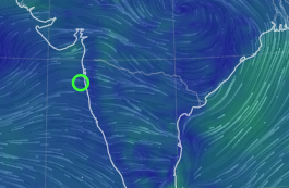
A cyclonic circulation in mid levels (~700 hPa) near Kerala coast expected to bring moderate rain/thundershowers along Kerala and Karnataka coasts and Ghats. 

700 hPa winds

Wind instability and the effect of this cyclonic circulation is causing heavy thunderstorms near Bangalore region and interior Tamil Nadu. This can persist for another 2 days. 


The earlier estimated low pressure area BB-12 may form in central Bay of Bengal by 7th/8th September and track west-northwest, towards north Andhra Pradesh coast. The monsoon trough which is close to Himalayan foothills, will move south towards the Bay low. This can increase rainfall for central India as well as set-up an offshore trough along west coast enhancing rains along konkan and Goa by the end of the week. 


Mumbai :

FAQ: Is the rainy season ending ?...No hurry...

We can get Rain/thundershowers in some areas, along with warm and humid weather. Rainfall likely to increase Thursday 8th, onwards 

Pune: Rain/thundershowers likely through the week, warm and humid, but turning pleasant after rain. Moderate to heavy thundershowers likely in some parts of the city and district. 

Interior konkan (Thane/Palghar districts) and Ghats have more chance of heavier thundershowers for next 2 days. 


Madhya Maharashtra belt of Nashik, Dhule, Jalgaon, Ahmednagar, Pune, Satara, Sangli, Kolhapur, Solapur districts can get moderate thundershowers. Heavy rain in some localized areas is likely. 

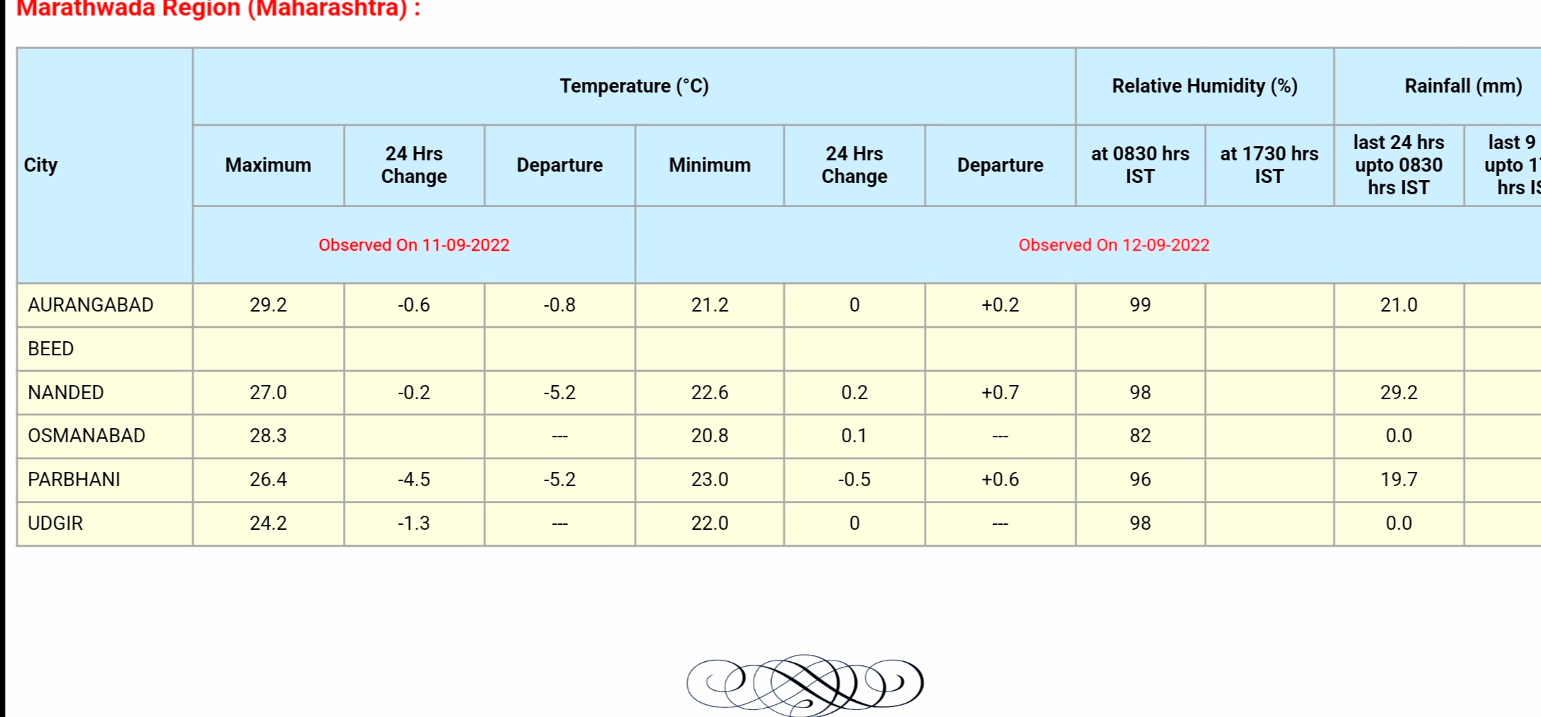
Marathwada region of Aurangabad, Jalna, Beed, Parbhani, Latur, Nanded to get light to moderate rain/thundershowers during this period. Some localized heavy showers possible.   

Vidarbha region to also get light rain in some parts, more chance of heavier rain towards end of the week once BB-12 moves inland. 


Heavier rain along konkan coast may possibly occur by the coming weekend, as westerlies strengthen, giving peak monsoon feel once again. 

Gujarat region may see increase in rainfall from/after Friday. 

Forecasts can change to some extent and not all places will receive well spread rainfall (given the thunderstorm nature of the rain). 

More updates as BB-12 develops. 

Monsoon withdrawal from west Rajasthan not expected anytime soon, not before mid September at least. 

Saturday, September 03, 2022

Saturday 3rd Post:

For the next week ..5th - 9th,  to see  increase in rainfall in Odisha, M.P, interior Mah , we observe the upcoming BB -12, likely to form in Central Bay around 7th.

The UAC  off Kerala is also to be


monitored...the BB -12 will strengthen the West Coast off shore trough by 8th, resulting in good rains in Kerala,  Coastal Karnataka. Goa and Konkan ( including Mumbai), next week.

This is an initial observation, more on Monday  5th with the developing situation. 

The Monsoon Axis slides South...So, a few days wait to announce the SWM withdrawal. 


Forecasted East rough  Let's look into the 3rd week of March ( 17th - 21st). Mumbai : Hot weather likely for Mumbai region this week, ty...