Sunday, August 28, 2022

Ganesh Chaturthi and Ganpati festival weather outlook: 30th August till 2nd September 

Weakening of Monsoon westerlies, and a NW deflection seen, will give rise to thunderstorms across interior parts of Maharashtra, Karnataka, Telangana, Tamil Nadu and Kerala. 


Surface winds ☝

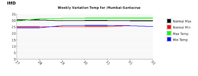
Mumbai and Konkan: Hot and humid weather as westerlies weaken. More chance of some thundery development and patchy showers in interior konkan, eastern MMR and Thane districts, less chance for the city. 

Ghats and hill stations ( Lonavala/Mshwar) can receive thundershowers during afternoon/evening. 

Pune: Afternoon/evening thundershowers likely after warm and humid morning. Localized heavy rain possible. 

------------------------------

३० ऑगस्ट ते २ सप्टेंबर गणेशोत्सवानिमित्त हवामान अंदाज:

मुंबई व कोकण: नैऋत्य व पश्र्चिमेकडून येणाऱ्या मान्सूनच्या वार्‍यांचा वेग कमी होत असल्याने, गरम व दमट हवामान राहील. कोकणाच्या अंतर्गत भागात, व मुंबईच्या पूर्वेकडील भागात (ठाणे जिल्हा) गडगडाटासह पावसाची‌ शक्यता आहे. किनारपट्टी जवळपास (मुंबई शहर व उपनगरात) देखील काही भागात गडगडाटासह पाऊस पडू शकेल. 

पुणे: गरम व दमट दिवसानंतर, दुपारी/संध्याकाळी गडगडाटासह पाऊस पडण्याची शक्यता आहे. काही भागात जोरदार वादळी पाऊस पडू शकेल. 

मध्य महाराष्ट्रातील नाशिक, पुणे, सातारा, अहमदनगर, कोल्हापूर, सोलापूर, जळगांव, सांगली या सर्व जिल्ह्यात दुपारी/संध्याकाळी गडगडाटासह पावसाची शक्यता आहे.

--------------------------

Marathwada regions of Aurangabad, Jalna, Beed, Nanded can get light to moderate rain/thundershowers from 30th August. 

Farmers advised to not work in open fields/farms during rain as it could be accompanied by lightning. 

मराठवाडा: ३० ऑगस्ट ते २ सप्टेंबर दरम्यान औरंगाबाद, जालना, बीड, नांदेड जिल्ह्यातील काही भागात गडगडाटासह हलका ते मध्यम पाऊस पडू शकतो.

पाऊस विजांच्या कडकडाटात पडण्याची शक्यता असल्याने, शेतकर्यांनी पाऊस पडत असताना शेतात कामे करु नये.

Madhya Maharashtra region has the highest chance of seeing thundershowers with some heavy rain in parts. 

Districts such as Nashik, Pune, Satara, Ahmednagar, Kolhapur, Solapur, Jalgaon and Sangli can witness afternoon/evening thundery development from Tuesday 30th August till Friday 2nd September. 


Rainfall likely to be unevenly distributed, given the thundery and convective (heat and instability triggered) nature of the rain. 


Bangalore, Mysore, Belgaum, Dharwad and most parts of interior Karnataka likely to receive good thundershowers over next 3-4 days. 

Gujarat: Mainly dry weather across the state, warm and humid. 

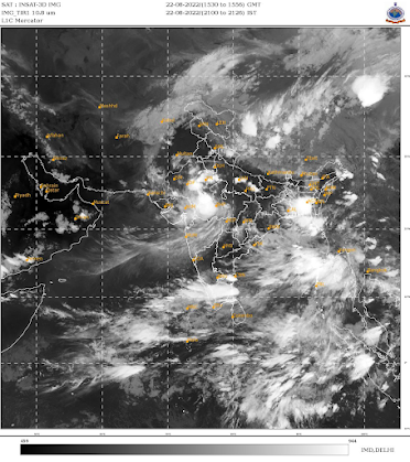
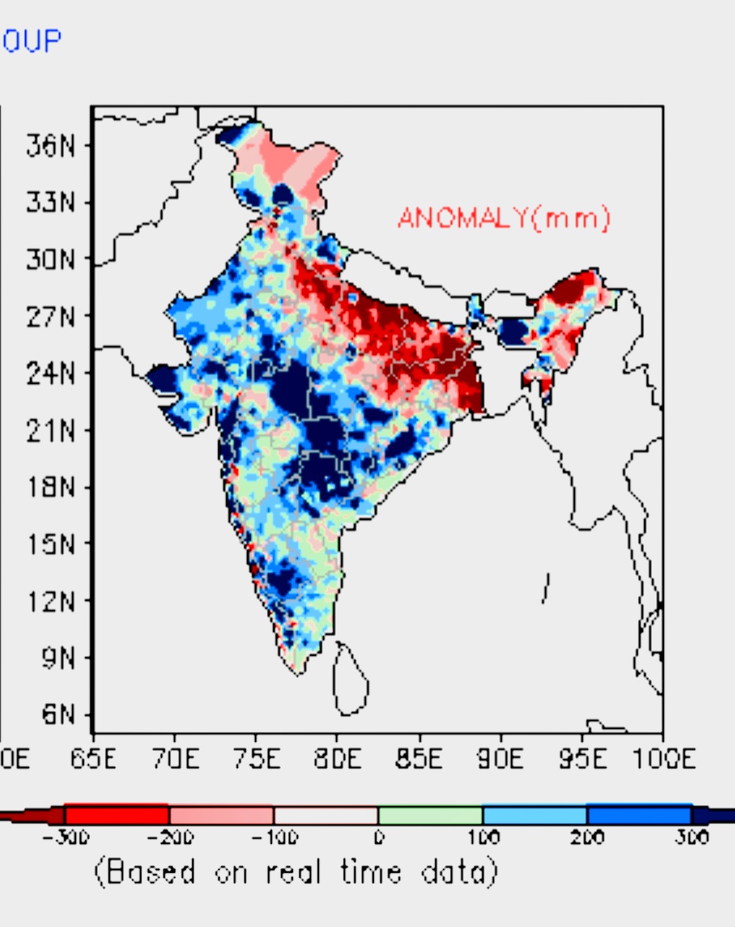
East India to continue getting patchy thundershowers (some localized heavy), across east Madhya Pradesh, eastern Uttar Pradesh, Bihar, Jharkhand, Chhattisgarh, Odisha and West Bengal. 

Friday, August 26, 2022

 26th August 

FAQ on Kerala Weather for next 3 days 

No major Alert.But few heavy showers ( exceeding 50 mms) possible in Districts of Kottayam, Idduki, Ernakulam and Wayanad. 

IMD map

Thursday, August 25, 2022

 25th August..

Current  Trough at 850 level..👇 slightly South in the West Sector..UAC over Jharkhand 


The Jet Streams at Easterlies are normally placed..so SWM not in premature hurry to withdraw 👇


200 level👆


Wednesday, August 24, 2022


The vagaries of the monsoon:The unpredictability of the monsoon alongwith phenomena like monsoon troughs and depressions lead to uneven distribution of rainfall.

While the monsoon in India is currently at 9 % above normal.But,  the distribution is uneven across the country. and could lower this year's foodgrain production.

Rains have been geographically uneven, with concentration seen in central (+25%)and southern India (+24%), trailing in the northwest and a steep 19% below-normal in the east and the northeast.

But no cause for Alarm.  If proper systems track on the required route (U.P., Jharkhand), things can still improve. 

(We are hopeful of BB 11)


Monday, August 22, 2022

Weather Outlook from August 23rd to 25th

Parade of lows/depressions keeping the Monsoon active

BB-10 lies as a depression over Madhya Pradesh, causing very heavy rainfall. 

BB-10 likely to move west, increasing rainfall over Gujarat region and southern, eastern and southwestern parts of Rajasthan, including Thar desert. 

Gujarat: 23rd-24th August - Moderate to heavy rainfall likely in Ahmedabad, Gandhinagar, Mahesana regions, moderate showers over Kutch and light to moderate in parts of Saurashtra. 

Bharuch region can receive light rain.

Udaipur and Mount Abu regions of Rajasthan likely to receive heavy rains on 23rd August, decreasing from 24th. 

[Mumbai, Konkan and Goa: Occasional passing showers to continue, some maybe moderate to heavy. No major change in current weather. So, Mumbai Colaba remains in 4% deficit though SantaCruz is in surplus. 

Rain likely to reduce after 25th August. 

But no worries..Mumbai Lakes @ 96% Storage have 1 year's availability. 

Pune: Pleasant weather with drizzles and light rain showers for next 2-3 days, reduction in rain and rise in day temperatures after 25th August. 

All Pune Dams are at 100% capacity...comfortable position. ]

Mainly dry weather likely for Marathwada region, which would be beneficial for the crops. 

Uttarakhand and Himachal Pradesh could see moderate rain/thundershowers in the low-mid Himalayan ranges. Upper reaches could get light snow. 

Avoid travel due to chances of landslides/mudslides. 


We await another low, BB-11, which could possibly form over north Bay and near West Bengal by 24th, but won't be as strong as BB-10. Rainfall could increase over West Bengal, Jharkhand and parts of north Chhattisgarh and east Uttar Pradesh. 

Most of Uttar Pradesh still faces big rainfall deficit,

with only marginal improvement likely in next 3-4 days. 

Weaker westerlies would result in increased chances of thundershowers over Bangalore region and parts of Tamil Nadu including Chennai and Pondicherry.


 22nd August...BB 10...Westward...

M.P....Bhopal 190 mms, Sagar 175 mms, Guna 174 mms, Jabalpur  160 mms.

In cms 👇


Kota (Rajasthan) recorded 224mm rain in the last 24hrs, this is the highest 24hrs rain recorded there in August in history breaking the record of 31 August 1978. Source: IMD

Meanwhile not a single day this August Delhi (Safdarjung) recorded double-digit rain. Huge rain deficiency

Input by Vag. Vineetkumar. 

Saturday, August 20, 2022

20th Evening 


 Massive Rainfall in H.P ...rain in cms as on 20th  Morning 


Friday, August 19, 2022

 BB 10 crosses  coast as DD on Friday evening 


Huge effect of BB 9 Depression in Sindh Region..

2022 - Annual Rainfall till date of Upper/Central Sindh:

▪️ JACOBABAD ➖ 546 mm (All Time Highest)

▪️ ROHRI ➖ 501 mm (All Time Highest)

▪️ SUKKUR ➖ 484.5 mm (All Time Highest)

▪️ MOENJODARO ➖ 535.8 mm (All Time Highest)

▪️ LARKANA ➖ 511.5 mm (2nd Highest)

▪️ SAKRAND ➖ 555 mm (2nd Highest)

▪️ DADU ➖ 455 mm (3rd Highest)

▪️ KHAIRPUR ➖ 479.5 mm (2nd Highest)

sent by Zohair (Karachi)

19th Morning Depression has formed in the Bay of Bengal, this is the third depression of this month in the Bay. With 3 depressions so far, this is the highest number of depressions in August in the Bay of Bengal after 2006. 
Info from Vag Vineet


Thursday, August 18, 2022

August 18th Night Update
BB 10 faces favourable conditions for very development into Depression. SST at 29/30c and positive upper divergence in the SW.

Heavy rain likely in Gangetic West Bengal, Jharkhand, North Odisha, East Madhya Pradesh. parts of east Uttar Pradesh over next 1-2 days.
 
Mumbai, konkan and Goa: Rain can increase after Sunday 21st as BB-10 moves west and keeps offshore trough active along the west coast . 
Pleasant weather for Ghats with some heavy showers and cool winds.
(Compiled byVag Shreyas Dhavale )

August 18th posted....Low Pressure  BB 10..moving West...to become Depression 


Tuesday, August 16, 2022

Posted 16th Night

Maharashtra except Vidarbh (Konkan, Madhya Maharashtra and Marathwada) to get decrease in rainfall from 17th to 20th.

For Madhya Maharashtra and Marathwada, this could be good for the standing crops. Water situation is reasonably comfortable.

For Wednesday 17th to Saturday 20th:

Mumbai: Reduced rainfall with periods of sunshine. A few Passing showers. 

Mumbai water situation is comfortable as today, with 11 months Stock.

Pune: Warm days as we get few light showers. 

बुधवार 17 ते शनिवार 20 पर्यंत:

मुंबई : सूर्यप्रकाशासह थोडा पाऊस पडेल. काही पासिंग शॉवर.

मुंबईतील पाण्याची परिस्थिती आज आरामदायक आहे. 11 महिने साठवण.

पुणे: उष्ण
दिवस आणि हलक्या सरी शक्य आहेत.

BB 9 moves West into Western  Gujarat and Kutch into Sindh. 

Heavy rains on 17th in Kutch and Western Saurashtra. 

Await BB 10 in 4 days....

Karachi: 

City received between 15 to 45 mms rain on 16th.

 Can get showers in Karachi next 2 days. Exceeding 60 mms cumulative. 

-‐--------------------------------------

विदर्भ वगळता महाराष्ट्रात (कोकण, मध्य महाराष्ट्र आणि मराठवाडा) 17 ते 20 तारखेपर्यंत पावसाचे प्रमाण कमी होईल.

मध्य महाराष्ट्र आणि मराठवाड्यासाठी, हे उभे पिकांसाठी चांगले असू शकते. पाण्याची परिस्थिती पुरेशी आरामदायक आहे.


Monday, August 15, 2022


Mumbai Water Storage


BB-9 Effective Rainfall in Regions as on 15th August Morning :

Monday Evening Image


Odisha 

The chief amount of rainfall recorded in cms are: Th Rampur (Kalahandi) 37, Kotpad (Koraput) 29, 

K Nuagaon (Kandhamal) 23, Kalampur (Kalahandi) 22, Dabugan (Nawarangpur) 21, Baliguda (Kandhamal) 21, Batagaon (Sambalpur) 21, Madanpur Rampur (Kalahandi) 20, 

Papadahandi (Nawarangpur) 19, Mandira Dam (Sundargarh) 19, Rajgangpur (Sundargarh) 18, Lanjigarh (Kalahandi) 18, Jaipatna (Kalahandi) 18, Phiringia (Kandhamal) 18, Borigumma (Koraput) 18, 

Ambabhona (Bargarh) 17, Ambadola (Rayagada) 17, Kosagumda (Nawarangpur) 17, Bhawanipatna (Kalahandi) 17, Gudvela (Bolangir) 17, Narla (Kalahandi) 17, Nawarangpur (Nawarangpur) 17, Bamra (Sambalpur) 17, Nawarangpur Pto (Nawarangpur) 17, Chakapad (Kandhamal) 16, Jharsuguda (Jharsuguda) 16, 

Kashipur (Rayagada) 15, Nandahandi (Nawarangpur) 15, Boudhgarh (Boudhgarh) 15, Sohela (Bargarh) 15, Tikabali (Kandhamal) 15, Tentulikhunti (Nawarangpur) 15, Karlamunda (Kalahandi) 15, Junagarh 

Chattisgarh:In mms

 Narayanpur 185.2 , Pakhanjur 176.6    Pusaur 173.3, Chaurasiya 173.8  Mohala 131.4, Baderajpur 121.9 ,Dondi 126.9  

Balod 83.9 Dharamajaigarh 43.5 Maakdi 185.1 Dondilohara 86.0 Kharsiya 96.6 Gunderdehi 64.9 Lailunga 70.1 DANTEWADA Dantewada 80.2 Kuwakonda 65.4 Gurur 80.. Ambagarh 123.8 SURAJPUR Surajpur 26.4 Antagarh 149.8 Dongargaon 122.1 Bhaiyathan 44.2 Dongargarh 123.8

Sunday, August 14, 2022

14th August ..Night:   

Depression BB - 9 moves inland, crossing  into G.West Bengal/Odisha and expected to track thru Odissa/Chattisgarh/East M.P.   Monsoon trough in Central India active next 2 days.


Monday 15th/Tuesday16th , Heavy effective rains ( Raipur, Bhopal, Nagpur around  75/85 mms),in the above regions and Vidharbh. 

Delhi : 15th August and 17th will see some showers in Northern Delhi NCR..and warm day at 32/33c.  

15th/16th/17th Forecast:

Bharuch (Gujarat): Medium heavy showers on 15th/16th/17th , adding upto 50 mms cumulatively. Decrease in rainfall after 3 days.

Surat/Valsad: Good rainfall next 3 days with some heavy showers..adding upto 50-70 mms in next 3 days.


15th/16th/17th Forecast:

Mumbai: After a 5 day period of less rains ( 10-12 mms/day), Frequency of rain increasing on Monday15th and Tuesday 16th. Intermittent showers during the next 2 days ( 30-40 mms/day). Slight decrease on Wednesday 17th.

Pune: Steady enjoyable weather. Cloudy, cool , days at 27c and light rains. 

मुंबई: 5 दिवसांच्या हलक्या पावसानंतर (10-12 मिमी/दिवस), सोमवार 15 आणि मंगळवार 16 रोजी पाऊस वाढत आहे. पुढील 2 दिवसांत मधूनमधून सरी (30-40 मिमी/दिवस). बुधवार 17 रोजी किंचित घट.

पुणे : चांगले हवामान. ढगाळ, थंड, दिवस 27c वर आणि हलका पाऊस

Aurangabad & Marathwada: Medium heavy showers on 15th August, 15-20 mms. Emough to  soak the fields. 16th/17th decrease in rainfall and only cloudy weather.

Jalgaon: Expect some medium heavy showers on 15th August, around 20-30 mms. Decrease thereafter with cloudy skies. Around 31c.

औरंगाबाद आणि मराठवाडा: 15 ऑगस्ट रोजी मध्यम मुसळधार पाऊस, 15-20 मि.मी. शेत भिजवणे. 16/17 रोजी पावसात घट आणि फक्त ढगाळ हवामान. 

जळगाव: 15 ऑगस्ट रोजी सुमारे 20-30 मिमी काही मध्यम मुसळधार पावसाची अपेक्षा करा. त्यानंतर ढगाळ आकाशासह पावसाचे प्रमाण कमी होईल. सुमारे 31c.

Karachi : Expect some medium showers on Monday/Tuesday due to UAC.( See Winds image above).


Friday, August 12, 2022

AS-3 westward movement may stall, probably move northwards and it will weaken by tomorrow.

So far 2 depressions have formed in the Arabian Sea 

For the first time in history (since 1891) both july and August saw a depression formation in Arabian sea...stats by vag.Vineet 

Posted at 6.30 pm IST


Thursday, August 11, 2022

Weekend Weather 12/13/14 ,August 

Mumbai: Occasional passing showers with some sunshine. A passing heavy shower will be brief with gusty winds...No Alerts.

Pune: Typical Pune season Weather, cool and pleasant. At around 27c ,it will add to the cool atmosphere with light showers.

12/13/14 ,ऑगस्ट हवामान

मुंबई : मुंबई: अधूनमधून पावसाच्या सरी (श्रावण सरी) आणि सूर्यप्रकाश. पाऊस पडत असताना वार्‍याचा वेग जास्त असेल.

पुणे : पुण्याचे सामान्य हवामान, थंड. सुमारे 27c तापमानात, हलक्या सरींनी थंड वातावरणात भर पडेल.

Lonavala: Perfect enjoyable outing Weather. Showers and fog.

Madhya Maharashtra and Marathwada: Light rains with ⛅️ clouds. Break needed to prevent over watering.

Things change next week with more rains as BB 9 makes it's advance. 

मध्य महाराष्ट्र आणि मराठवाडा: ढगाळ वातावरण, हलका पाऊस‌. पिकांसाठी पावसाची विश्रांती आवश्यक, मात्र पुढच्या आठवड्यात काही भागात पाऊस पून्हा वाढू शकेल.

Further addition:

Another low BB-9 to form by Saturday over North Bay. Rain increasing over Odisha, Chhattisgarh, Jharkhand and east MP over the weekend

Delhi: After a warm weekend, thundershowers possible on Sunday. 

Bharuch: pleasant weather with few showers. 

By Co Author  Shreyas

 BB 8 effect in Gujarat 


Tuesday, August 09, 2022

 9th  August...

The "Alert" Region for Konkan, after an effective try on Monday,  shifted North with the trough...hence all rain concentration on Tuesday is in Gujarat, M.P, Rajasthan and Chattisgarh..

.


Rainfall will concentrate in the region of the trough next 2 days.
Moderate rains in Gujarat.

Mumbai: Monday saw fairly good rains commencing, as seen in the map of Mumbai Rains. The trough having shifted North, the "Alert" for Mumbai can be downgraded.
Now, Reducing rains with Passing passing showers with a few heavy falls. Around 25-30 mms/day.

मुंबई : मुंबईच्या पावसाच्या नकाशात दिसल्याप्रमाणे सोमवारपासून बऱ्यापैकी पावसाला सुरुवात झाली. कुंड उत्तरेकडे सरकल्यामुळे मुंबईसाठीचा "अलर्ट" कमी केला जाऊ शकतो. आता: कमी पाऊस आणि काही सरी. सुमारे 25-30 मिमी/दिवस.

Posted on 9th August 2022 Afternoon

And the Orange alert is Active!


Some rainfall figures from Mumbai Metropolitan Region and around ending at 8:30am on 9th August 2022 in the map below!

Data Credits: MCGM, IMD & IITM


Sunday, August 07, 2022

Posted 7th August Sunday:

Outlook for 8th/9th /10th:

Mumbai:Orange alert for Mumbai for next 3 days 8th, 9th & 10th August. 

Meaning heavy rains with Thunder expected on 8th Monday and 9th Tuesday. Local areas getting waterlogged. Expected to exceed 175 mms rainfall in two days ....Can expect Gusty winds also.

Pune: Orange Alert in Pune regions for heavy rains on Monday and on Tuesday to some extent...Exceeding 100 mms in 2 days. Very cool days om 8th/9th at around 24c. 

Mahabaleshwar: Very heavy rainfall with foggy conditions.

Lonavala: Frequent heavy showers with fog...Heavy rains expected in the 3 days. Travel safety necessary

Aurangabad: Not much relief from the wet outfields in Aurangabad. Steady frequent showers expected on 8th /9th/10th..around 15-20 mms/day. reducing on 10th

Jalgaon Region: Showers with thunder persisting in the mentioned 3 days. With wet conditions and rainfall around 25 mms/day.

Goa: Fairly frequent showers persisting in Goa for the 3 days in mention...Rainfall exceeding 100 mms.in 2 days initially.

Gujarat Region and Saurashtra can expect moderate Showers on 8th/9th/10th..with most palces in the region exceeding 40 mms/day.

Bharuch: Frequent rains on the 3 days mentioned with pleasant temperatures. Around 25mm/day.

Delhi: With not much rain conditions, temperatures expected to rise with days getting hot to around 36/37c.

The BB-8 has become Well Marked in the Bay off Odisha Coast. The System will deepen more, hence the above forecast.

.

Saturday, August 06, 2022

 BLUE JET LIGHTNING SIGHTED OVER TEXAS: Seeing one blue jet is rare. Photographer Matthew Griffiths just caught several of them over the Big Bend National Park in Texas. "This is by far the best," he says:


Above: A blue jet emerges from a thunderhead in Big Bend National Park, photographed by Matthew Griffiths in Marfa, Texas: more.

Friday, August 05, 2022

Heavy rains in Aurangabad today ( Friday)..46 mms in 12 hrs

Aurangabad District, Mah. Crops in good condition,  need a break from rains and some bright weather...was informed when we gave our snippet forecast for Aurangabad 

Pics from Aurangabad Farms.👇


Posted 5th August..Afternooon

BB-8 & BB-9 weather systems are  expected to form in Bay of Bengal shortly. The 1st one forms around 7thAug and the 2nd low pressure develops on 11th/ 12thAug.  

Both the systems  will take the track stretching across the central parts of India and travelling till far west to Gujarat and Rajasthan.

Good rains expected next week in Goa, Konkan,Chattisgarh, M.P, and Gujarat.


Thursday, August 04, 2022

 New Delhi

After a break, rain and thundershowers will return to Delhi NCR. 

A feeble cyclonic circulation or a UAC may form over and around Delhi on 5thAug.  rain showers, in the Delhi between 5th and 7th August. Intensity of showers will be more on 5th and 6th August.  Again,  warm and humid conditions with partly cloudy sky from 08th 

Around 35-40 mms expected in  the period.

A W.D as a trough in the westerly winds, prevails over North Pakistan and adjoining region. This will keep the trough close to the Himalyan foothills  for the next 3 days. 


 On World Weather News.Page


July heat records shattered across the U.S.


Wednesday, August 03, 2022

 Special Forecast for Madhya Maharashtra


Parts of Pune, Nashik, Dhule, Ahmednagar, Satara, Sangli, Solapur, Kolhapur, Jalgaon districts can get convective rain/Thundershowers in some parts for next 1-2 days.

Tuesday, August 02, 2022

 Check " World  Weather News" page on blog 

Special Mumbai Outlook:...Posted on 2nd August Evening.

The mid Monsoon dry spell in Mumbai likely to end later this week. With strengthening of westerly winds from the Arabian Sea, rain can increase from Friday 5th August in Mumbai, with more frequent passing showers expected during the day. 

The hot days may see an improvement in temperatures by a drop of about 2° in the day. But sultry conditions ..to continue.

Last week's Temperatures..👇


Weekend of 6-7 August may see more frequent moderate to heavy showers 🌧  parts of Mumbai Metropolitan Region.

The lakes and Water position is comfortable at around 88%Storage..

 For the Month of August, rainfall for Mumbai likely to be around normal....About 575 mms.

Goa: Starting with heavy rains on 4th Thursday &Friday, rainfall 🌧 increase for the weekend. 

 2nd August 

Kerala got increasing rains as predicted (snippet 👉...) ..but coastal Karnataka event was surprising...Compilation by Vagarian Shreyas

Kochi AP 211mm

Mandya 143mm

Kochi 138mm

Valparai 128mm, Thrissur 125mm

Eranakulam district 

Neriyamangalam 171mm

Odakkali 156, Muvattupuzha 140

Kochi 136, Kalamassery 121

Choondi 116, Palluruthy 110

Extreme rain event in coastal Karnataka

Muttalli (GP) 533.50

Mundalli (GP) 521.50

SUSGADI (BHATKAL) 517.50

Mavinkurve (GP) 491

Koppa (GP) 483.50


Shirali 288mm

Widespread 500mm in Uttara Kannada dist

This was not in the prediction line..The reason seen in this upper wind directions(700 levels)


 And Sea Levels winds


Monday, August 01, 2022

Forecasted East rough  Let's look into the 3rd week of March ( 17th - 21st). Mumbai : Hot weather likely for Mumbai region this week, ty...