Vagaries© of the weather.blog written by rajesh kapadia.concentrating on meteorology of the Indian sub continent and extreme world weather since 55 years For Any Information taken from here, due credit must be given to Vagaries.
Saturday, July 31, 2021
Friday, July 30, 2021
Brazil's Historic Snowfall..July 2021...See World weather News page
Posted 30th Morning:
Yesterday's Rain around Pune Ghats: Mahabaleshwar 80 mms, Matheran 70 mms, Khandala 41 mms
BB-7 in full strength over West Bengal..moving towards South Bihar
Thursday, July 29, 2021
Posted 29th Afternoon:
Outlook for the weekend next 3 days.
Mumbai: Last few days Mumbai has been getting some occasional passing showers/ sunny periods in parts of city.
On Friday 30th, Mumbai can expect a little more rain and increased frequency. (Say around 25-30 mms)
But this will be on Friday, and Saturday /Sunday may be back to occasional showers. (Upto 10-15 mms/Day).
No Alert.
Pune: Pune has been getting scattered showers in parts of the city. Friday 30th will see a slight frequency increase, restricted to one day. Pleasant weather with temperatures ranging between 28-21c. Windy conditions.. Making it feel 20c at night.
Ghats region around ( Lonavala/Mahabaleshwar) will get frequent passing showers. Few heavy. Foggy weather. Around 40- 70 mms per day.
No Alerts
Wednesday, July 28, 2021
Tuesday, July 27, 2021
Monday, July 26, 2021
Outlook for 27th/28th/29th:(This week till Thursday/Friday)
Mumbai: Partly cloudy with occasional rain showers. Warm in the day with periods of sunny weather. Not expecting very heavy rains, but around 20-35 mms per day.
No Alerts.
Mumbai Lakes:
Pune: Light to moderate rains in parts of city. Slight increase in frequency on Friday. Pleasant days around 28/29, but Friday will show a drop to 26c.
Low Alert for Lonavala, Mahabaleshwar Ghat sections. Expect around 30-60 mms/day.
Pune Reservoirs on 26th:77% Storage.
Aurangabad District: Partly cloudy and Light to moderate rain scattered over the region. Not expecting very heavy showers. West winds could be strong.
Temperature around 30c in the day.
औरंगाबाद जिल्हा: अंशतःढगाळ आणि हलका ते मध्यम पाऊस या प्रदेशात पसरलेला आहे. खूप जोरदार पावसाची अपेक्षा नाही. पश्चिमेकडून येणाऱ्या वार्याचा वेग जास्त असू शकतो.
दिवसात 30°C च्या आसपास तापमान राहिल.
Posted 26th Evening:
Extreme Rainfall from BB-6 as on 26th Morning (24hrs): (In cms)
Rajasthan: Marwar 21, Bhungra 17, Danpur & Arthuna 16, Garhi 15, Banswara, Arnod & Dug 14, Pratapgarh 12.
M.P.: Jaora, Kathiwada & Mahidpur 26, Zirapur 22, Pachod 21, Jharda 19, Alirajpur & Garoth 16, Nateran, Barod , Piploda & Bajna 15.
Gujarat: Lodhika 20, Chotta Udaipur 19, Quant 18, Becharaji 16, Tilakwada & Kalawad 15, Kaprada 14.
From 27th, Rain intensity decreasing in Rajasthan, West M.P. & Gujarat.
--------------------------------------------------------------------------------------------------------------------
Mahabaleshwar in Maharashtra had a very wet 7 days this week of July 2021:
20th 110 mms
21st 164 mms,
22nd 480 mms
23rd 594 mms
24th 321 mms
25th 187 mms
26th 154 mms....
Totally 2010 mms (80 inches) in 7 days !!
(Extreme Rain of Jor in Maharastra given below) ⬇⬇
Phenomenal Rains in Jor (Maharashtra)
Jor , Maharashtra is a small village some 10-15 kms from Mahableshwar.
It got phenomenal rains in 5 days, worth mentioning here.
19th July 137mms,
20th July 184 mms
21st July 756 mms,
22nd July 646 mms
23rd July 433 mms
2156 in 5 days !! 86 Inches !!
Of course cannot compare, But the season's total in Cherrapunji till date is 3540 mms.
These lovely videos are taken in Jor by Eliza, "Mysticstays". (Courtesy Vag. Abhishek Apte)
Sunday, July 25, 2021
Weather Knowledge -31
Heat Wave Hits Tokyo Olympics...See World Weather News page
Image of Sunday Afternoon.. True to 23rd forecast
Saturday, July 24, 2021
Friday, July 23, 2021
Mahableshwar records it's highest ever one day rain ever... 595 mm on 23rd July.
Beating previous highest of 491 mms recorded on 11Aug 2008
How Pune, in leeward side got heavy rainfall today.. In spite of active off shore trough... See this upper air (500 level) wind flow.. Moist winds inflow at upper level, bringing thunder and favourable conditions for thunder (CAPE)
Pune district rainfall from 8:30am-8:30pm(12hrs) on Friday 23rd as follows:
1.Girivan:111
2.WadgaonSheri:99
3.Pashan IITM(Bag Pvt Reading):83
4.Pune IMD:78
5.Bibwewadi(Vag Pvt Reading):68
6.Talegaon:59
7.NDA:55
8.Lonikalbhor:39
9.Vetale(Khed):37
10.Dudulgaon,#Walhe(Purandar):31
11.Rajgurunagar:21
Data compiled by:Vagarian Abhishek Apte
Posted 23rd Afternoon:
Mumbai Forecast ➡➡➡
Unusually Very Heavy Rainfall in Maharshtra Ghats..Tulshi Dam (Radhanagri) records a record 895 mms in 24 hrs !
Also check the huge amounts (Red) in Map
Forecast from Friday 23rd July till Sunday 25th July:
Bay low BB-6 located near Odisha/West Bengal border. Likely to move in a WNW direction.
Today 23rd July will see moderate-heavy rain across Odisha and Chhattisgarh.
Entire Madhya Pradesh to witness moderate-heavy rain over next 3 days. Intensity can be on the heavier side for west MP.
Gujarat regions of Bharuch, Vadodara, Ahmedabad along with southeast Rajasthan may see increase in rainfall on the weekend.
Maharashtra :Entire west coast will witness rainy weather due to active offshore trough from south Gujarat to Kerala. Moderate to heavy rains expected today along the entire west coastal regions throughout. Rain intensity gradually reducing over Kerala and coastal Karnataka from tomorrow
Madhya Maharashtra region likely to get light to moderate showers, pleasant weather with cool winds. Intensity may reduce on Sunday.
North Madhya Maharashtra region of Jalgaon, Dhule, Nandurbar likely to get some moderate to heavy rain today
Light to moderate rain today and tomorrow in Vidarbha and Marathwada regions (Aurangabad, Jalna).
Rainfall was much above expectations over Kolhapur region (Kolhapur city 147 mm in last 24 hours). However, such magnitude of rain is not expected now.
Western Ghats region can again expect heavy rain today, although may not be as heavy as last 2 days. Intensity to reduce from tomorrow, however heavy passing showers may still continue over Maharashtra Ghats till Sunday.
Contribution from Vag. Shreyas
Aurangabd district will get moderate rainfall till 26th. good for the standing crops.
पैठण / Jayakwadi Dam - Paithan, Aurangabad. At 35.41% of its full compared to 41.00% at the same time last year.
औरंगाबाद जिल्ह्यात 26 तारखेपर्यंत मध्यम पाऊस पडेल. स्थायी पिकांसाठी चांगले.

पैठण / जायकवाडी धरण - पैठण, औरंगाबाद. मागील वर्षी याच वेळी 41.00% च्या तुलनेत त्याच्या 35.41% पूर्ण आहे.
Standing crops doing well in Aurangabad District
Thursday, July 22, 2021
Posted 22nd Morning
Source rtsfros
For Mumbai S'cruz...2021 now breaks the record for the fastest 2000 mm mark . Achieved on 22nd July 2021 in 52 days ! Total today 2001 mms !
The record for the fastest 2000 mms at Santa Cruz was in 1965, when it touched 2000 mms on 30th July, in 60 days. Followed by 2005 when the total was surpassed on 31st July, in 61 days.
July End Totals..Scruz 1965 ;2038 mms, 2005 :2019 mms..
Colaba, just for the records, has crossed 2000 mms by July 3 times. In 1886, 1907 and 1991. But, we are still way behind for this station to cross 2000 mms by July end.
(As per Vagaries Records)
Crazy Rains in Maharashtra Ghats... Vagaries spot on forecast under estimated
Satara and Pune district Ghats rain ending 8:30am on 22/07/2021 (in mm):-
1.Jor:756
2.Valvan:495
3.Mahabaleshwar:480...24 hrs record is 491 mms in 2008.. 11th Aug.
4.Davdi:458
5.Shirvali(Bhor):432
6.Navaja:421
7.Jambhali:380
8.Nivale:357
9.Koyna nagar:341
10.Pratapgad:332
11.Kole(Pawana):332
12.Bhimashankar:318
13.Kumbheri:305
14.Warasgaon:299
15.Savale:292
16.Moleshwar(Kanher):288
17.Khandala:276
18.Khireshwar(near Malshej, Junnar tal):273
19.Nira Deoghar Dam:261
20.Temghar Dam:241
21.Kaas:240
22.Tarali:240
23.Thoseghar:239
24.Dhom Balkawadi Dam:225
25.Ghisar:221
Wednesday, July 21, 2021
Posted 21st morning:
Outlook for 21st & 22nd
Active west coast offshore trough will result in heavy rain over konkan and Goa regions. A low pressure area BB-6 (currently as a UAC over north Bay of Bengal) likely to descend to surface level near Odisha/West Bengal coast by 22nd. Likely to track NW.
This will further keep the rains active along the west coast and Ghats region due to strengthening pull effect westerlies from the Arabian Sea.
Due to these conditions, rain also likely to increase to moderate /heavy in Vidarbha and Telangana regions (from tonight and persisting till tomorrow) along with parts of Odisha and West Bengal.
Pune,, Kolhapur, Nashik, Satara: Light to moderate showers, cool breezy and pleasant weather.
Parts of Marathwada close to Telangana may see some light to moderate rain.
Coastal Karnataka, Karnataka ghats & Kerala likely to get increased rain.
Forecast coordinated with Vag. Shreyas.
Tuesday, July 20, 2021
Thane district and Navi Mumbai rainfall figures ending 8:30am on 20/07/2021(in mm):-
1.Kalyan:368
2.Badlapur(Vag Pvt Reading):302
3.Bhiwandi:300
4.Ulhasnagar:288
5.Ambivali:267
6.Ambarnath:253
7.Mumbra:236
8.Diva:192
9.Ghansoli:173
10.KoparKhairane:167
11.Sanpada:166
12.Thane:161
13.Airoli:157
14.Kopri:138
15.Vashi:121
16.Belapur:119
17.Nerul:106
18.Shahapur:103
Monday, July 19, 2021
Monday 19th
#DelhiRains till 8:30AM💯
#Sonipat 145.5mm
#Gurgaon 145.0mm
#Narela 104.0mm
#Delhi AP 99.3mm
#Najafgarh 95.0mm
#Pitampura 70.5mm
#Safdarjung 69.6mm
#Faridabad 68.0mm
#LodhiRoad 62.0mm
#Ridge 58.0mm
#Ayanagar 51.6mm
#Akshardham 43.0mm
Compiled by Navdeep (Rohtak)
S Gujarat yesterday received widespread extremely heavy rains here is the list (min cut off 100 mm)
Sent by Vagarian Shitij ( Surat)
1. Umergam 237 mm
2. Vapi 232 mm
3. Kamrej 209 mm
4. Bardoli 202 mm
5. Palsana 197 mm
6. Mahuva 162 mm
7. Valsad 162 mm
8. Dolvan 160 mm
9. Jalalpore 159 mm
10. Surat city 146 mm
11. Navsari 138 mm
12. Vyara 136 mm
13. Dharampur 131 mm
14. Gandevi 124 mm
15. Khergam 123 mm
16. Tilakwada 119 mm
17. Chikli 115 mm
18. Kaprada 107 mm
19. Songadh 102 mm
More rains data of today from Mumbai Region
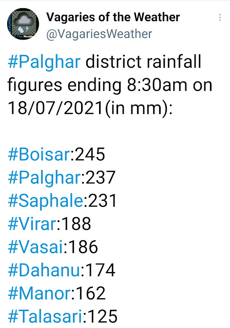
Thane district and Navi Mumbai lashed with heavy rains. 24hrs rainfall figures from 8:30am-8:30am on 19/07/2021are as follows (in mm):
1.Ulhasnagar:400
2.Ghansoli:261
3.Sanpada:249
4.Mumbra:237
5.Airoli:231
6.Shahapur:200
7.Diva:188
8.Koparkhairane:185
9.Kalyan:180
10.Nerul:174
11.Vashi:171, 12.Dombivli:167
13.Thane:166, 14.Bhiwandi:155
15.Kalwa:153, 16.Ambivli:129
Compiled by: Vagarian Abhishek Apte
Sunday, July 18, 2021
Posted Sunday 18th Afternoon:
Unexpected Cloudburst in North Konkan and specially Mumbai on Saturday Night into Sunday.
Off shore trough activated due to vertical wind shear (surface winds are SW and 700 at N. CAPE is favourable.
Because of this, there was strong Thunderstorm formations along the coast.
North Konkan and South Gujarat coast "jump" the forecast and leap 1/2 days ahead ! This "jump" Good for the Lakes*.
The outlook remains as given earlier, (though advanced by Nature to show its "Vagaries'' to Vagarians) 😉
Good rains ahead for Mumbai and Lakes.
Overall Storage at 19.83 % ( 2020 this date 26.71% and 2019 was 50.78%.)
Saturday, July 17, 2021
Maharashtra Special:
Major parts of State in Excess or Normal category.
Extreme North Maharashtra (A few Districts) seeing some deficiency.
*Note: Although most of Maharashtra looks normal or excess, it does not reflect the water stock in the reservoirs. Most of the catchment areas (lakes/dams, river sources) being in the vicinity of western Ghats, due to less rain in the Ghat region, the water storage is low for western Maharashtra. Also, Vidarbha region average storage is 35% as of now.*
Outlook for next 5/6 days for all regions of Maharashtra ...till 22nd July:
Konkan: Good rainfall, with few heavy falls in all districts, will continue till 20th.... after 20th heavier rainfall and increase in intensity seen, with very heavy falls (after 20th) in Konkan.
The off shore trough will persist and remain active..extending rainfall into South Gujarat as well.
Mumbai: The current spell of the wavering rainfall (On suddenly heavy thunder showers/and sudden sunshine) will continue till 20th. Though some of the showers will be heavy. 35-60 mms/day average.
Increase in frequency and intensity after 19th/20th for the next 2/3 days at least. 40-90 mms/day possible, with 100+mm also likely in some areas of MMR.
This time, active offshore trough along west coast will lead to strengthening of westerly winds. So catchment areas in interior konkan as well as Western Ghats belt likely to receive heavy rain.
Madhya Maharashtra & Marathwada: No major let up in the current spells of rain. But increase seen in Southern Parts of Madhya Maharashtra (including Pune) and Marathwada after 20th July (increase for 2 days).
Vidharbha: Not much rainfall on weekend (17th/18th). But increasing after Monday 19th to moderately good intensity. Increase for 2 days.
Overall, increase from 20th..and the Excess & Normal will be maintained. Few deficient districts may remain in Northern Madhya Maharashtra.
Posted 17th July Afternoon:...Gujarat Special.
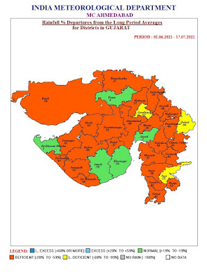
Rain Deficiency is high in Gujarat till date:
For the Next 5/6 days..Till 22nd July...Middle of Next weekSaurashtra :Not much improvement in meaningful rainfall to wipe out the deficit. There can be some moderate rainfall in Coastal Saurahtra (Helping the Porbundar Deficit).
Kutch: Very little rainfall seen in small patches of Kutch region. (Nalliya and Kandla Regions ).
South Gujarat Region: Surat /Valsad and the Coast will get moderate showers till 22nd on a daily basis = around 15-30 mms (Surat) and 25-45 mms (Valsad). Few heavy falls expected.
The off shore trough will persist and remain active..extending rainfall into South Gujarat.
Bharuch light to moderate showers daily around 10-15 mms/day and increase on 19th/20th/21st.
North Gujarat Region; Patchy rains in some pockets with no major rain amounts. Around 5-15 mms/day.
Overall, for Gujarat, good satisfactory rain in Coastal Gujarat Region, but deficiency may not be much reduced in rest this week.
Middle of week after 21st some increase seen.
CHIEF AMOUNTS OF RAINFALL IN CM.
GUJARAT REGION 07-17-2021: Madhbun (dist Dadara & Nagar Haveli) 2, Khergam (dist Navsari) 2, Kaprada (dist Valsad) 2, Khanvel (dist Dadara & Nagar Haveli) 2, Radhanpur (dist Patan) 2, Kheralu (dist Mehsana) 2, Silvassa (dist Dadara & Nagar Haveli) 1, Valia (dist Bharuch) 1, Nanipalson (dist Valsad) 1, Jetpur Pavi (dist Chhota Udepur) 1, Sagbara (dist Narmada) 1, Bayad (dist Aravalli) 1
SAURASHTRA & KUTCH 07-17-2021: Kalyanpur (dist Devbhoomi Dwarka) 5, Porbandar (dist Porbandar) 4, Naliya (dist Kutch) 3, Abdasa (dist Kutch) 3, Rajula (dist Amreli) 2, Junagadh (dist Junagadh) 2, Dwarka (dist Devbhoomi Dwarka) 2, Visavadar (dist Junagadh) 2, Jetpur (dist Rajkot) 1, Bhesan (dist Junagadh) 1, Babra (dist Amreli) 1, Manavadar (dist Junagadh) 1, Kutiana (dist Porbandar) 1, Ranavav (dist Porbandar) 1, Jasdan (dist Rajkot) 1, Dhoraji (dist Rajkot) 1, Vadia (dist Amreli) 1
Friday, July 16, 2021
Posted 16th
Good overnight rains in North/Central Mumbai...
Rainfall activities of frequently heavy showers continue in Mumbai as discussed in the previous post.
Elongated UAC off Mumbai coast causing heavy rain for city and suburbs. But as westerlies not strong till ~4 km altitude, so cloud bands restricted to coastal areas
Thursday, July 15, 2021
Today Vagaries celebrates 15 years of sharing Weather knowledge...that is celebrating its Crystal Anniversary...symbolising clarity and transparency...truly applicable to Vagaries!
Wednesday, July 14, 2021
Posted 14th Wednesday Night
For Mumbai next 2/3 days ( Thursday/Friday/Saturday):
Mumbai is getting frequent showers currently. Colaba received 39 mms & Scruz 9 mms ( All locations got between 9 & 40 mms) in the day on Wednesday.
Same, frequently heavy showers to continue for next 2/3 days. Very windy during showers and pleasant.
Pune: occasionally raining on Thursday. Rain strength getting lighter on Friday & Saturday. Cool days.
Aurangabad District : like happening now, showers will continue for another 1 day. Slightly less after Friday. But not absolutely dry. Cool weather.
औरंगाबाद जिल्हा: जसे आजच्या सारखे, सरी आणखी 1 दिवस सुरू राहतील. शुक्रवार नंतर थोडेसे कमी पण पूर्णपणे कोरडे नाही. थंड हवामान
Tuesday, July 13, 2021
Author's View:
Monsoon moves into Delhi.. 13th July.
Lot of debates attacking the IMD for not getting the North and NW India forecast correct.. This year.
All praise to IMD for correct forecast track of Cyclones, Depressions and severe weather. Then why the flak now ?
IMD is our National Agency.. and in charge of the total Region !
Today, can anyone predict anything, in any field? Doctors will give us a remedy, medicine. But if we ask the doctor, tell me how much fever will I have tomorrow at 12 o clock.. Can he tell us Exactly?
Nothing can be projected/predicted in finance, medical field or even an uncontrollable thing like a pandemic.
Monsoon is not in our control. Yes, there are computers, satellites and radars. But that observes/calculates, not manage.
Come on..
We are Meteorologists, not Magicians.
"Monsoon 2021 expected to move into Delhi by 11th July. Thunder Showers expected from 9th .
Monday, July 12, 2021
Posted Monday Night 11pm IST
UAC which formed off Mumbai coast yesterday, moved in a northwest direction and has descended into a low (AS 2) off the Saurashtra coast. Saurashtra & Kutch region may get Thundershowers for another 2 days. Monsoon moving in.
The ( Upper Air) trough line now runs through Gujarat/Maharashtra into the Bay.
With AS 2 moving in a northwest direction, westerly winds from the Arabian Sea have strengthened over Mumbai and north konkan region along with the formation of offshore trough.
Heavy rain and thunder expected for Mumbai MMR on Tuesday & Wednesday along with entire konkan-Goa coast.
On Monday, Mumbai Colaba recorded 49 mms and Scruz 43 mms in the day.
Pune can get light to moderate showers on Tuesday & Wednesday. Another cool day on Tuesday.
Karachi and Sindh Coast will be getting showers on Tuesday 13th. Monsoon moving in.
Assisted by Vag. Shreyas
Posted 26th Night Mumbai Santacruz seasonal rainfall crossed the 2000 mms mark on 26th...reaching 2003 mms. For your information: Sant...
-
Pune recorded 87 mm ending 8.30am today. With this achieved 1000 mm mark! Seasonal Rainfall stands on 1018 mms now. Last night Widespread...
-
Pradeep has put up the Hill Sates rain amounts from F-1 on his Page.. See Update on F-2 and latest as on Wednesday Night on Current weat...


