Vagaries© of the weather.blog written by rajesh kapadia.concentrating on meteorology of the Indian sub continent and extreme world weather since 55 years For Any Information taken from here, due credit must be given to Vagaries.
Sunday, October 31, 2021
Friday, October 29, 2021
Posted 29th Night:
Low Pressure system heralding the NEM along the T.N. coast and A.P. coast will move inland. NEM expected to remain active in T.N, from 30th for next 4 days.
Strong Easterly wind flow at the upper level ( 1500 metres above sea Level) will bring in much moisture into interior Karnataka and southern Maharashtra from the 1st of November.
Increasing cloudiness and possibility of light/moderate rain/Thundershowers in parts of South Madhya Maharashtra & Southern Marathwada region from 31st October to 3rd November.
No rain expected in Aurangabad.
South Konkan, Goa and Western Ghats will be getting getting some rain 1st -3rd November.
South Konkan Rice fields , undergoing removal now, need to be protected.
Mumbai: after some "lesser humidity " experience, Mumbai may witness increasing humidity from Sunday. some clouds shading the sky on weekend and Monday. Temperature range, warm, between 33c - 24c. Real feel 35c.
Pune: Partly cloudy from Sunday ...and rise in night temperatures from Sunday. Light to moderate rain expected (Thunder) from 1st -3rd November.
Goa: Expect light to moderate rains from 31st October - 3rd November.
31 ऑक्टोबर ते 3 नोव्हेंबर या कालावधीत दक्षिण मध्य महाराष्ट्र आणि दक्षिण मराठवाडा विभागाच्या काही भागात ढगाळ वातावरण आणि हलका/मध्यम पाऊस/ मेघगर्जनेसह पावसाची शक्यता.
औरंगाबादमध्ये पावसाचा अंदाज नाही.
दक्षिण कोकण, गोवा आणि पश्चिम घाटात १ ते ३ नोव्हेंबरपर्यंत थोडा पाऊस पडेल.
दक्षिण कोकण भातशेती, आता काढली जात आहेत, संरक्षित करणे आवश्यक आहे.
-----------------------------------------------------------------------------------------------------------------------------=========================================================================
Courtesy Shri Hosalikar
Monday, October 25, 2021
25th October... SWM Withdraws.. & NEM sets in.
(Estimated earlier in Vagaries on 14th)
See (below) complete withdrawal dates from country in last 46 years. Mark the date trend in last 10 years. (IMD)

Tamilnadu, Puducherry & Karaikal: Madurai-11,
Pudukkottai-10, Tiruppur, Toothukudi-8 each, Kodaikanal-4 each;
Interior Karnataka: Kodagu-8, Shivamoga, Mysuru, Dharwad, Mandya-7, Hassan-3;
Kerala: Palakkad-6
Low Pressure now likely to develop in South Bay more and move towards T. N. Coast by 27th.
Effective rainfall will move inland into Karnataka and Southern Madhya Mah. ( Kolhapur, Sangli, Satara) around 1st week November.
Chennai:
Heavy rainfall is expected between 29th and 30th October. Will extend into early November.
Localised flooding, thunderstorm and gale winds is likely, with the monsoon making a good onset.
Sunday, October 24, 2021
Posted sunday 24th October
No rain expected in Marathwada till month end.
Except for little rain in South Konkan on 24th,
No rain elsewhere in Maharashtra State till October end.
Cooler night temperatures.
रविवार 24 ऑक्टोबर रोजी पोस्ट केले

मराठवाड्यात महिनाअखेरीपर्यंत पावसाची अपेक्षा नाही.

24 रोजी दक्षिण कोकणात थोडा पाऊस वगळता,

ऑक्टोबर अखेरपर्यंत महाराष्ट्रात इतरत्र पाऊस नाही.
रात्रीचे थंड तापमान.
Saturday, October 23, 2021
Thursday, October 21, 2021
Posted 21st October
Delhi may see cloudy skies with some light rainfall around October 24.
Vagaries has mentioned Partial South West Monsoon withdrawal on 14th October (In Post). Complete withdrawal now by 24th...and Commencement of NEM from 24th/25th October.
Tuesday, October 19, 2021
19th October...
Heavy Rains likely again in Kerala and South Karnataka (read Bangalore) from 21st - 23rd October...Then SWM may withdraw..
The Approaching easterly Wave will bring in NEM around 25th Oct to T.N. and Coastal A.P.
As NW winds resume over NW India, cooler nights in the plains expected from 21st onwards (12-15c).
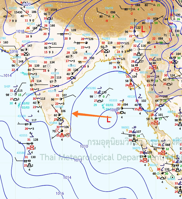
BB-15, System moved as per by arrow shown yesterday...
Rainfall Massive amounts for Uttarakhand... In mms
Significant Rainfall amount recorded (from 0830 hours IST of yesterday to 0830 hours IST of today)(in cm):Monday, October 18, 2021
Posted Monday 18th Night
Heavy interaction rains in many States. W
Uttarakhand heavy rain as warned.. Nainital's Iconic Mall flooded as lake overflows. AWS records 361 mms till 11 pm Monday.
Char Dham Pilgrims advised to postpone.
Significant Rainfall amount recorded (from 0830 hours IST of yesterday to 0830 hours IST of Monday 18th): in Cms
West Madhya Pradesh:- Sheopur-31, Datia-17, Shivpuri-15, Bhind-14; Agar-Malwa,
Rajgarh,Sehore-11 Each; Guna, Gwalior-10 Each; Indore, Ujjain, Shajapur-8 Each; Vidisha, Harda-
7 Each; Barwani-6;
Odisha:- Balasore-21, Mayurbhanj-13, Cuttack-11, Keonjhargarh-7;
Uttarakhand:-Champawat-16, Nainital-10, Pithoragarh-9, Udham Singh Nagar-8, Almora-7;
East Rajasthan:- Baran-16, Karauli-13, Bhilwara-7;
Kerala & Mahe:- Thrissur-13, Ernakulam-11, Kozhikode-7;
Gangetic West Bengal:-East Midnapore-12; South 24 Parganas, West Midnapore-11 Each.
Tamilnadu:- Coimbatore-11;
East Madhya Pradesh:- Tikamgarh-10;
Haryana:- Palwal-9; Delhi:- Safdarjung-9, Aya Nagar-7;
Yes, the interaction resulted in the rainy and WD weather, bringing much below normal day temperatures to NW India.
Huge Drop in Day Temperature in NWI today Monday 18th.
Recorded Max & departure from Normal:
Delhi:
Ridge 23.0°c (-9° Below Normal)
Ayanagar 23.6°c (-9° BN)
Lodhi Road 23.8°c (-8° BN)
Safdarjung 23.9°c (-9° BN)
Palam 24.4°c (-8° BN)
Ridge 23.0°c (-9° BN)
Jafarapur 24.3°c (-9° BN)
West Uttar Pradesh:
Muzaffarnagar 21.8°c (-8° Below Normal)
Meerut 22.0°c (-11° BN)
Aligarh 22.6°c (-10° BN)
Bulandshahr 22.7°c (-)
Moradabad 23.0°c (-8° BN)
Najibabad 23.0°c (-)
Baghpat 24.3°c (-)
Agra 24.5°c (-10° BN)
Bareilly 25.9°c (-6° BN)
Jhansi 27.6°c (-6° BN
Haryana:
Narnaul 22.5°c (-11° Below Normal)
Mahendargarh 23.4°c (-)
Panchkula 23.6°c (-)
Yamunanagar 23.8°c (-)
Chandigarh 24.0°c (-8° BN)
Ambala 24.2°c (-7° BN)
Sonipat 24.3°c (-)
Rohtak 24.6°c (-9° BN)
Kurukshetra 24.9°c#(-)
Gurgaon 25.2°c (-)
Hisar 26.9°c (-6° BN)
Rajasthan:
Bair 22.9°c (-)
Alwar 24.6°c (-9° Below Normal)
Dhaulpur 24.9°c (-)
Karauli 25.1°c (-)
Sikar 26.7°c (-7° BN)
Churu 27.0°c(-8° BN)
Jaipur 27.0°c (-6° BN)
Bundi 27.7°c (-)
Data source: IMD
©LWI (Navdeep)
Sunday, October 17, 2021
Mumbai...This day.. That Day
Heat Wave and Heat Record for Mumbai Santa Cruz:
Friday 16th October 2015 turned out to the Hottest October day ever for Mumbai S'Cruz...Recording 38.6c (5.2c above normal).On Thursday, S'Cruz saw a high of 37.2c.
The previous hottest was on 23rd October 1972 when 37.9c was recorded.
Vagaries.
Friday, October 15, 2021
Posted 15th October afternoon
Low pressure are BB-15 forms in the Bay of Bengal, may become well marked. Likely to move in a west-northwest direction, cross north AP and adjoining south Odisha coasts bringing heavy rain in these regions. South Chhattisgarh, Telangana and Vidarbha to get moderate rain with heavy in some places over next 2 days.
Vidarbha region may witness rain from 16-18 October, parts of Marathwada and north Madhya Maharashtra (Jalgaon, Dhule) may see light to moderate rain during 16-18 October. Less chance for Pune, although some increased cloudiness with warmer night temperatures.
A western disturbance in the form of a trough in the westerly jet stream at 200 hPa is likely to develop over the North West subcontinent.
This is likely to result in rain across north India. Sunday 17th and Monday 18th October will see rain/Thundershowers across UP, NCR region, parts of Haryana and Punjab.
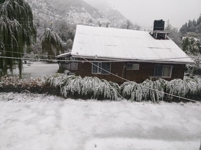
Himachal Pradesh may witness moderate rain and higher reaches snow. Uttarakhand along with parts of Nepal likely to witness heavy to very heavy rain/snow, with threat of landslides triggered by very heavy precipitation. *Avoid Travel to Uttarakhand* from 17-19 October.
The UAC over Arabian Sea has descended to form a low pressure area AS 2 near the Lakshadweep region. This will bring strong moisture laden westerlies and moderate-heavy rain for Kerala, southern Karnataka and Lakshadweep region over next 2 days.
Compiled by Vag. Shreyas.
Pune district cools down!
Some minimum temperatures from Pune district on 15/10/2021(in °c):-
1.Malin:17.6
2.Pabal(Shirur):18.1
3.Loni Kalbhor:18.3
4.NDA & #Pune IMD:18.8
5.Talegaon:18.9c
6.Lakadi(Indapur):19.6
7.Dudulgaon & #Daund:19.7
8.Junnar:19.9
9.Walhe(Purandar):20
10.Bibwewadi(Vagarian Pvt Reading):21
Data Credits:IMD
Compiled by: Vagarian Abhishek Apte
Thursday, October 14, 2021
14th October 2021
Mumbai:
Southwest Monsoon 2021 finally to withdraw from Mumbai & Pune.
Mumbai: Monsoon had made a strong onset on 09 th June, with 3 occasions of 3 digit rainfall in 24 hr and is likely to depart by Thursday 14th.
Mumbai has been receiving few retreating showers since the beginning of month and these are likely to cease. However, 14th onwards, rains will recede giving way to marginal rise in day temperature with partly cloudy sky.
Mumbai: SWM Rainfall 2021
S'Cruz : 3164 mms...6th time after in last 21 years...Third consecutive year more than 3000 mms. ( Annual 2021 till end September 3420 mms.)...
Colaba: 2332 mms. ( Annual 2021 till end September 2590 mms)
Last year, 2020 Mumbai had the wettest monsoon (3856 mms) and the most delayed withdrawal on record, 26th October.
In fact, even 2019 saw good rainfall of over 3500 mms
Tuesday, October 12, 2021
Outlook for Gujarat & NEM 2021 Below:
Posted Tuesday 12th Night:
(Heavy Rain Pre Informed in Snippet )
Karnatak
Bengaluru Kempegowda International Airport recorded highest rainfall of 178.3 mm on today, the 12th Oct 2021 surpassing the previous all time record of 86.4 mm which was recorded on 27th May 2017. 0830
As on 12th Morning, Southwest monsoon was vigorous over South Interior Karnataka and active over Coastal Karnataka.
Heavy rainfall amounts (in cm)
Bengaluru KIAL 18;
Bargur, Sira (both Tumakuru dt) 12 each :
Madhugiri, Bukkapatna (both Tumakuru dt) 9 each;
Nippani (Belgavi dt), Annigeri (Dharwad dt), Kottigehara (Chikkamagaluru dt), Hoskote (Bengaluru Rural dt), Channagiri (Davangere dt), Pavagada (Tumakuru dt) 7 each.
On Tuesday 12th , heavy rainfall till 6.30 pm...Honavar 180 mms, Udupi & Mangalore 77 mms.
Kerala:
Mannarkkad (Palakkad district) 24,
Kozhikode 22.
Anakayam ARG (Malappuram district) 19,
Quilandi & Vadakara (both in Kozhikode district) 18 each,
Kannur, Pattambi (Palakkad district) & Peringalkuthu AWS (Thrissur district) 17 each,
Mahe (Puducherry UT) 15,
Punalur (Kollam district) & Thalassery (Kannur district) 14 each,
Vadakkancherry (Thrissur district), Parambikulam (Palakkad district) & Keerampara ARG (Ernakulam district) 13 each,
Thodupuzha ARG (Idukki district) & Mattannur ARG (Kannur district) 12 each,
Thodupuzha (Idukki district), Thrithala (Palakkad district), Angadipuram & Nilambur (both in Malappuram district), Vellarikkundu AWS (Kasaragod district), Vynthala ARG (Thrissur district) & Cheruthazham ARG (Kannur district) 11 each,
Perinthalamanna (Malappuram district) & Thenmala ARG (Kollam district) 10 each,
14 મીએ ગુજરાત માટે ચોમાસુ પાછું ખેંચશે.
ચોમાસાના દક્ષિણ ગુજરાત અને સૌરાષ્ટ્ર માટે છેલ્લા 2 દિવસ. ગઇકાલે ચર્ચા મુજબ 14 મીએ પાછી ખેંચી લેશે.With the possibility of low BB-15 developing in Bay of Bengal and remaining at North AP/Odisha latitude, lower winds will continue to be mostly westerlies/South Westerly over Southern Bay for another week.
Monday, October 11, 2021
Posted 11th October Afternoon:
The South West Monsoon will loose its steam and strength over Maharashtra, Gujarat, M.P. by 13th October.
The "Monsoon wind pattern" and Monsoon current will be diminishing from 13th. (In Gujarat, Maharashtra, Goa, M.P. Telengana and N.I.Karnatak) where it will withdraw further .
Gujarat Monsoon withdrawal from 14th October completely.
Hot weather will prevail over Kutch and western Rajasthan from 13th..as also rise in temperature and hot weather in North Konkan.(Including Mumbai).
But, for Interior Maharashtra, there is a possibility of some recurring Post Monsoon rains in Vidharbh , Madhya Maharashtra and Marathwada around 18th/19th. This will /may occur if the announced system from the Bay ( BB-15) heads towards the State. Keeping the options open., but very necessary for the farmers to know about this post monsoon showers.
All dams in Marathwada 100% full (Jayakwadi 98%).
Mumbai & Pune: Last couple of days of thunder showers possibility on Monday/Tuesday or at the most Wednesday. Then Mumbai & Pune can bid good bye to the Monsoon.
Hot & sunny weather from Thursday 14th.
Mumbai Water Storage at 99%. .Pune Khadakvasla 69%..All others 100%.
Pune: But, System BB-15 can bring rain to Pune after the monsoon is over . Keeping the options open for some post monsoon showers for Pune on 18th/19th.
परंतु, अंतर्गत महाराष्ट्रासाठी, 18/19 च्या सुमारास विदर्भ, मध्य महाराष्ट्र आणि मराठवाड्यात मान्सून नंतर काही वारंवार पावसाची शक्यता आहे. खाडीतून (बीबी -15) घोषित प्रणाली राज्याच्या दिशेने गेली तर हे होईल /होऊ शकते. पर्याय खुले ठेवणे., परंतु शेतकऱ्यांना या मान्सूननंतरच्या सरींबद्दल माहिती असणे अत्यंत आवश्यक आहे.
मराठवाड्यातील सर्व धरणे 100% भरली (जायकवाडी 98%).
14 મી ઓક્ટોબરથી ગુજરાત ચોમાસુ સંપૂર્ણપણે પાછું ખેંચશે.Sunday, October 10, 2021
Pune district reports heavy thundershowers!
Good rains accompanied with lightning and thunder lashes Pune district. Some figures ending 8:30am on 10th October,2021(in mm):
1.Lakadi(Indapur):93
2.Alandi:85
3.Lohegaon, WadgaonSheri & Velhe:77
4.Dudulgaon:76
5.Chinchwad & Bhatghar:74
6.Daund:72
7.Koregaon Bhima:70
8.Yavat:61
9.Pune IMD & Rajgurunagar:55
10.Mundhwa:46
11.Bibwewadi (Vag Pvt Reading):41
12.Waki:39
13.Talegaon Dhamdhere:38
14.Pirangut:34
15.Temghar:33
16.Magarpatta & Kothrud:28
17.Pashan(Vag Pvt Reading):26
18.Mulshi:16
19.Walhe(Purandar):15
20.Loni Kalbhor:14
Data compiled by: Vagarian Abhishek Apte
Saturday, October 09, 2021
Friday, October 08, 2021
" Jawad" .. Or a little lesser intensity system next week..? From the announced BB 15...lets monitor
Posted Friday 8th October:
Mumbai/Pune 8th/9th/10th: : Evening Thunder Showers will occur on this weekend. Some parts of city may experience heavy showers and Lightning.
Saturday & Sunday will possibly heavy showers in many parts of City.
South West Monsoon Withdrawal Probable date:
BB-15, Low, may form in Bay around 10th/11th..Track Westwards initially.
UAC formation seen in Arabian Sea off west Coast..May bring heavy thunder showers to Mumbai & Goa this weekend.
Maharashtra Monsoon staying till 15th at least.
महाराष्ट्र मान्सून किमान 15 तारखेपर्यंत राहील.
By 10th Oct North Gujarat should be out of Monsoon Range.
Further Withdrawal from other Gujarat areas a bit uncertain due to possible BB-15 formation in Bay.
10 ઓક્ટોબર સુધીમાં ઉત્તર ગુજરાતનું ચોમાસું સમાપ્ત થઈ જશે.ખાડીમાં સંભવિત બીબી -15 ની રચનાને કારણે અન્ય ગુજરાતના વિસ્તારોમાંથી થોડું અનિશ્ચિત.
Wednesday, October 06, 2021
Tuesday, October 05, 2021
5th October Tuesday:
Withdrawal Process of South West Monsoon commences from extreme west Rajasthan..5th October...see below⬇
Pune district thunderstorm rainfall ending 8:30am on 5/10/2021:
1.Wadgaon Sheri:106
2.Loni Kalbhor:68
3.Magarpatta:53
4.Khengarewadi:50
5.Pabal:47
6.Talegaon Dhamdhere:44
7.Yerwada & Jejuri:39
8.Pune IMD:30
9.Saswad & Dudlgaon:37
10.Bibwewadi(Vagarian Pvt Reading):35
11.Lavale:32
12.Walhe(Purandar):30
13.Sansar(Indapur):24
14.Khutbav Daund:19
15.Lakadi(Indapur):17
16.Chinchwad & IITM(Pashan,Vag Pvt Reading):7
Data compiled by:Vagarian Abhishek Apte.
Withdrawal Process of South West Monsoon commences from extreme west Rajasthan..5th October...
Sunday, October 03, 2021
Friday, October 01, 2021
Posted 1st October Afternoon;
Monsoon This Year:
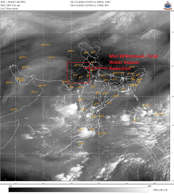
The Withdrawal indications of the Monsoon, Indications in the Upper Air anti cyclone , will start from Sunday 3rd October , from the Extreme West Rajasthan Region.
The actual withdrawal from Extreme West Rajasthan will be on around 5th October, a few days after the Water Vapour image shows it clearly.
Meanwhile,
Cyclone Shaheen forms in the Arabian Sea. May intensify to severe cyclone as it heads west towards Oman. Moving away from the Indian Region.
Western India Outlook for next 5 days:
As westerlies weaken and wind regime changes to easterlies, retreating monsoon Thunderstorms expected in parts of south MP, Gujarat and most of Maharashtra from tomorrow onwards. Madhya Maharashtra belt (Pune, Nashik, Jalgaon, Satara, Kolhapur) and adjoining western Ghats may receive moderate Thundershowers with some places getting localized heavy rain.
Interior Konkan has more chances than coastal Konkan, although almost entire Konkan belt may receive Thundershowers over next 5 days.
Mumbai:
Monsoon to remain in Mumbai, not withdrawing till at least another 10 days.
Mumbai MMR: Chance of Afternoon/Evening Thundershowers from Sunday/Monday 3rd/4th October.
Eastern outer townships may see some thunder activity from tomorrow.
Pune: Pune and neighborhood region likely to get late afternoon Thundershowers over next 4-5 days starting Saturday 2nd onwards. Some areas in Pune district may witness localized heavy thundershower.
Some patchy showers possible in a few areas in Pune district today.
Aurangabad: Next 3/4 days, Heavy Local Thundershowers in many areas expected in Aurangabad district.औरंगाबाद: पुढील 3/4 दिवस, औरंगाबाद जिल्ह्यात अनेक भागात जोरदार मेघगर्जनेची शक्यता आहे.
दुपारी/संध्याGoa: Monsoon showers/thundershowers to continue for next 10/12 days.
18th July Rainfall in cms

-
Much Awaited Monsoon Analysis to Date from ..None Other than Our GSB..on "Stats and Analysis" Page..Just Recieved On Saturday ...
-
Short Narration: Monday 1st/Tuesday 2nd : The heaviest rains are in Madhya Maharashtra, Marathwada, North Interior Karnataka and No...


