Thursday, May 31, 2012

Mumbai Lake Position Put up on Mumbai Page..


This IMD Image, super imposed with "A" and "B" by Vagaries, shows 2 distinct developments !I project this satellite image with winds movement to make things easier to explain. 
On the left (A)  is the developing low, as indicated by the wind directions around it. Getting ready in the next 24 hrs.
On the right (B) is the Monsoon cloud. The SW winds near the coast between the clouds and the mainland  is fairly convincing indicating the SWM to move into Kerala in the next 48 hrs.
More Later..


B1 now seen as a low 1t 996 mb, merged with the trough. Moved N/NE as expected and at 20.4N and 92.6E today (Friday). Rains expected in coastal regions to be heavy.


It's Reached 50c !


Larkana and Mohenjo Daro touched 50c today (Thursday, 31st May). Vagaries had been predicting and anticipating this since the last 2 days. 
Sukkur soared to 49c, and Dadu and Sargodha were 48c. Sukkur saw a low of 31c.
Yesterday vagaries had estimated a rise in the region for Thursday.
In India, Churu was hottest at 48.7c,  Allahbad was 47.8c. Amritsar was just short of its all time record by 0.2c. It was 47.6c on Thursday. Brahmapuri was also at 47.6c, Agra at 47.1c, Gwalior 47.0c, Chandrapur saw 47.0c. 


Delhi Palam baked at 47.0c, and S'Jung was sizzling at 45.4c
Kota bottomed a low of 33.8c and Nagpur 33.7c on Thursday morning.


Orissa was spared the extreme heat for the second day today. At least it was not as hot as it was before last Tuesday. Highest was 45.5c at Bolangir followed by 45c at Sundargarh. 


B-1 has moved N and was centered at 18.6N and 91E. It has not intensified much, and still remains as a UAC. Rainfall regions are very much restricted to the Eastern coast of Bangladesh and adjoining India.as yet. 
Should move N/Ne and track into Bangladesh, maybe just settling down as a low.


The low in the Arabian Sea should form by the 2nd of June. The low formation clouds are seen near the 57E 10N region. 
In the interim period before the low takes shape, I expect the SWM to advance into Kerala around the 3rd of June, as thick clouding has also concentrated south of the Lakshadweep Islands. 
Subsequent events will take its course as described yesterday.


For those interested, the Vagaries' Daily Weather Readings  from Breach Candy, Warden Road, South Mumbai have been recently put up on a special Page on this Blog.

Wednesday, May 30, 2012

Relentless Heat in India and Pakistan.


High day temperatures of Wednesday, 30th May:


In Pakistan, Sibi touched 49.0c, Jacobabad touch 48.5c, While Multan sees 48.0c. Sukkur soared to 47c. 
Islamabad saw an unusual high of 43c.


Wednesday,30th, in India, it was 47c at not only the usual  places in Vid. like Brahmapuri reached 47.6c Chandrapur saw 47c and Wardha at 46.9c , Allahbad at 46..8c, Nagpur at 46.6c, Agra at 46.5c and c, but the 47c has crept into Punjab with Amritsar touching 47.0c and Hissar at 46.4c today.


The Rajasthan Desert is in the 45/46c range with Ganganagar reaching 47.4c and Churu 47.2c. Bikaner and Kota at 45.8c and Jaisalmer seeing 45.4c,along with Delhi ( S'Jung) also at 45.0c on Wednesday.
Nagpur's minimum bottomed at only 33.6c today.


Absence of a WD and strong dry Westerlies have pushed up the temperature levels in the region. Before another WD moves in, we can expect the 
Rajasthan region to touch 48c and places in Punjab/Haryana soaring to 46/47c in the next 2 days. Delhi will remain in the 44/45c range till Saturday.


In Pakistan, Sindh region could touch 50c by Thursday/Friday, and Sukkur possibly reaching 48c.
From Monday, 4th, we can expect some relief, as SW winds start pushing thru the Sindh/Kutch coastline into the NW plains of the sub-continent. Moisture laden winds will sweep into the NW regions and bring much needed relief to the region, from Saturday.
Karachi could see some clouding and drizzle by the weekend.


Consequent to the formation of 92B, the Eastern States of Chattisgarh and Orissa got the much needed relief from the heat. Compared with last 8 days, Wednesday's highest was much lower at Titlagarh (44.5c) and Jharsuguda (44.3c). The hottest in the state was Malkangiri at 45c. Now these are lower than what the state has been seeing the last full week, 46/47c at several places.


Bay:
92B, now B1, will move N/NE, and will be the depression that was forecasted by Vagaries to hit Bangladesh (see June Forecast on Current Page). B1 is currently at 17.7N and 91E. Expecting heavy rainfall in Coastal Bengal, and pulling up the SWM into the NE states. 
Nepal will get some soothing rains as the system B1 moves inland/


Arabian Sea:
A low AS-1, will form in the Arabian Sea around the 2nd of June around the 10N and 60E region. System, AS-1, is expected to move Northwards and deepen to some extent initially for a couple of days. By the 5th, it will weaken and fade out in the Sea out before hitting land. 


Naturally, even a nominal system near the coast will "suck in" the Monsoon moisture, and weaken the SWM over Kerala. As the arrival of SWM coincides with the System, the monsoon will have an initial "resistance" to advance into Kerala, but move in it will. As it moves into Kerala by the 2nd/3rd of June, SWM could then suddenly weaken temporarily in Kerala, as the Arabian Sea low takes away all the moisture, and diverts the winds away. 


If the low, even for 3 days after forming, moves North, it can always pull up a weak SWM along the Karnataka/Goa coast by the 4th of June, as per Vagaries' earlier forecast, and maybe into Mumbai by the 9th of June, a few days earlier than expected.


The SWM can, however, may be restricted to the coast, and interior Mah. and Karnataka could be almost dry till the winds get re-organised. 
TN will remain devoid of the monsoon current till next week.


A deepening seasonal low in Sindh/Rajasthan at 994 mb in early June will draw moisture and clouds with strong SW winds into Saurashtra/Kutch and Coastal Sindh (East) regions, from Monday,4th June.


Later, some light rainfall and windy conditions could be expected along Saurashtra coast and Sindh (Pakistan) coast on 7th/8th.


Check Current Weather Page Regularly.

Tuesday, May 29, 2012

92B, a low forming in the Bay at 16N and 90E, South of Bangladesh.
Status of low formation in Arabian Sea same as given Below, no additional narration at this stage. Shall update in the evening if required.
Check Current Weather Page for June rainfall estimate (Revised) and SWM progress Map updated.

Low in Arabian Sea ?


A couple of International Forecasting Models estimate a low pressure to form in the Arabian Sea, around 10N and 60E by the 1st of June. There are few other models which do not agree and show NO low formation in the region around that time frame.


With 2 diverse opinions by several International Models, it becomes confusing for the average reader to actually judge or estimate the fact, especially at a critical time when the SWM is advancing along the West Coast of India.


Vagaries' View: 


Citing the "patch" of warmer SST in the Central regions of the Arabian Sea (around 55-60E), it is possible that a low pressure system can form in the region by the 1st/2nd June. A no. will be given when it forms.


But, as it travels North, it can encounter a slightly colder sea, thus limiting its growth. The low, initially could be at 1000 mb, can deepen to 996 mb by the 4th of June, before it starts weakening again from the 5th.


Effect: 
Naturally, even a nominal system near the coast will "suck in" the Monsoon moisture, and weaken the SWM over Kerala. 
As the arrival of SWM coincides with the System, the monsoon will have an initial "resistance" to advance into Kerala, but move in it will
As it moves into Kerala by the 2nd/3rd of June, it could then suddenly weaken temporarily in Kerala, as the Arabian Sea low take away all the moisture, and diverts the winds away. 


If the low, even for 3 days after forming, moves North, it can always pull up a weak SWM along the Karnataka/Goa coast by the 4th of June, as per Vagaries' earlier forecast, and maybe into Mumbai by the 8th of June, earlier than expected.


The SWM can, however, may be restricted to the coast, and interior Mah. and Karnataka could be almost dry


A deepening seasonal low in Sindh/Rajasthan at 994 mb in early June will draw moisture and clouds with strong winds into Saurashtra/Kutch and Coastal Sindh (East) regions.


Mumbai Forecast:


30th May: 33-28c. Partly cloudy with humidity rising. 


31st May/1st June: 34-29c.  Overcast morning with light drizzle in some parts of the city. Clouds getting sparse in the afternoon.


2nd June; 35-29c.  Cloudy morning and hot afternoon. Thunder clouds developing by afternoon/evening n the Eastern sky.


3rd June: 34-28c.  Cloudy and humid. Thunder clouds in the afternoon/evening with some rain in parts of the city.

Sunday, May 27, 2012

Hot Sunday !


Dadu in Pakistan @ 49c on Sunday, 27th May. One or Two places in the Region Expected to Touch 50c on Monday or Tuesday.
Karachi to Heat upto 39c and Sukkur may touch 45c by next 2 days.

India's Hottest on Sunday: Machilipatnam, Brahmapuri and Allahbad @ 47c.

Saturday, May 26, 2012


Monsoon Watch - 7


SWM has further moved into Southern Sri Lanka. Maldives and Northern Andaman Sea.
Galle in Sri Lanka recieved 63mms of rain and Ratnapura got 30 mms on Saturday, 26th, while Colombo measured 15 mms.


Cross Equatorial Flow has picked up considerably in the Bay and Arabian Sea. Winds over 30-35 knts are seen gushing Northwards off the Somali Coast, and 40 knts winds are seen in the Bay.
Winds off the Sri Lanka coast have picked up considerably.


Today's SST map is reproduced here to show the Sea temperature not falling sufficiently yet along the Somali coast. It is presently around 24c. Now, this difference with the Central Arabian Sea plays a key role in cloud formations off the Western Coastline of India in the Central Arabian Seas. The SST along the Somali coast will rapidly fall to around 18/20c in the next 10 days.


But the current fall is sufficient to help form Monsoon clouds around the Maldives. Cloud formation near Sri Lanka is gathering, and in next 24 hrs, wind speed along the Sri Lanka coast is estimated at 35 mph (in gusts). 
A slight fall is seen in the Bay water's SST.


The ITCZ is slowly moving up, but is still around the Equator regions, and in the 5N region in the Bay sector.


SWM should set in over Sri Lanka within next 24 hrs, that is by the 28th May. 


The Seasonal Low seems to have strengthened. We see today's pressure at 998 mb. Getting gradually ready enough to create a gradiant to pull up SW winds into the mainland. The day temperatures on the Sub-Continent Northern plains are on the higher side since Wednesday, with the average the day's highs are around 42/43c. Across in Pakistan' Sindh region, the core area for the formation of the low, the highest was 46c on Saturday. M-5 effect was expected bring about a slight fall in the day readings(reported in Vagaries yesterday).


M-5 is seen moving away from India. WDs should slow down now, as the jet streams at 200 hpa are re-grouping fast into position. 


The Jet Stream Westerlies are almost upto the 15N line, and the "High" formation is taking shape East of Bangladesh. Expected movement of this "High" should be inland towards MP for perfect position.


The Bay sector SWM has been stagnant, and not picking up as expected from a "setting in" Monsoon. Its lack of systems could be attributed to M-4/5. Strong westerly currents prevent the formation of lows to move into the bay and towards the Indian mainland. They divert the forming currents.
As SW winds should pick up speed in the next 2 days, SWM "in situ", could advance further into the Bay. Better before another WD reaches the region to spoil the  "party".


Conclusion: SWM advancing into Sri Lanka by 28th (late by 3 days). 
Advance into Kerala around Vagaries' expected date, 3rd/4th June. But, further advance would need monitoring. 
Possibly into Coastal Karnataka and Southern TN regions by the 7th of June. 
South Konkan and Goa around 8th June, and Mumbai by 13th/14th June.


Keep Checking Monsoon Advance Map on "Current Weather Page"


A local heat vortex developing may bring about a thunders shower in and around Chennai on Sunday,27th.


NW Sub-Continent day temperatures will further fall by around 2c next 2 days. However, the hot days in AP and coastal TN will see lower day temperatures from Monday, to the extent of 2.3c


See Mumbai Forecast on Mumbai Page.


Gwalior @ 34.5c.......Minimum Temperature Saturday Morning !


Friday, May 25, 2012


Today's Highs (Friday,25th):


India: Brahmapuri, Machilipatnam and Chandrapur: 47.1c. Wardha: 47c. Nagpur: 46.9c.
Lows at night: Nalgonda: 33.6c, Nagpur and Nellore : 33c. Brahmapuri and Kavali : 32c. Chennai: 31.7c.


Pakistan: Dadu: 49c, Larkana: 47c.
Lows at night: Sukkur: 31c, Jacobabad: 30c.


Current Temperature @ 11.00 pm IST on Friday is 34.4c.


Mumbai Forecast for Next Week on Mumbai Page


MW-7 will be published on Sunday Morning.

Thursday, May 24, 2012


Heat Wave Intensifies in Pakistan:


The maximum Day temperature in Pakistan rose on Thursday to 48.5c at Dadu. followed closely by Larkana at 48c and Padidan measuring 47.5c. Sibbi was at a high of 46c. Sukkur saw a high of 45.5c 
The nights are very moderate with Sibbi at 22c at Mirpur Khas dipping to 19.5c. 


In India, Adilabad and Rentachintala(AP) soared to 47c, with a low at 33c at Adilabad ! On Thursday, Chandrapur reached 46.8c and Brahmapuri 46.5c. Nagpur touched 46.2c in the day and was 31.8c at night (Thursday morning).


Heat wave expected to persist till Sunday in Coastal AP and Chennai. Chennai may reach 43c and pesisit till Monday between 41c and 43c. Minimums will be around 30c.
But  a slight let up is expected in Pakistan and NW India ( a couple of degrees drop) from Friday thru Monday. 


Pradeep reports from Chennai that it is 33c at 10 pm on Thursday night.....The day was 42c, and the real feel was 47c, on Wednesday and dropped only to 30.6c on Thursday morning..rare and unusual nights for Chennai !


Editorial Response to sset's comments:
Getting off track and going by un official reports on meteorogical is a common method of attracting media attention. These reports of 50 and over are unofficial figures, cannot be substantiated and not recognised as proper methods of recordings.
The Highest ever in Kothagudem is 48.6c on 9th May 1973.
Ramagundam's record high is 47.3c on 24th May 1984.
In fact, in recent years, the highest has been around 47/48c, and not touched 50c. There are many a reports, all unofficial about temperatures reaching 50c and so on. Its not so common or for that matter, things would become absolutely unbearable with disastrous consequences if places were to touch 50c at the drop of a hat. 
And the 58.01c report....  .01c...what does that mean ? The world's highest day temperature ever recorded anywhere on this planet is 57.8c in Libya. Record is not broken or touched yet. and the highest record for India is 51.1c at Purulia (as per wikipedia) and 50.6c as per official IMD records.
sset, one should not be mis lead by such reports and exaggerated figures...no meteorologist is going to swallow such claims.


And sset, though Ap and Interior Karnataka have received normal rains, maybe slightly below normal in pockets, it does not sustantiate or qualify for "drought" conditions. As per meteorological norms, and actually too, the rains are not that poor. 
Drought may prevail and spread due to various artificial reasons like poor watre management, poor planning, improper utilisation of rain water, or simply poor administration. 


I will only report and study the actual rainfall and deviation. I cannot comment whether there will be drought or shortage of water. It can be controlled and managed..that's not within the preview of Vagaries.

Wednesday, May 23, 2012


SWM Advance Map  Link  also put up on the Right Side of Home Page for Ready reference. Please check Frequently for updates of Monsoon Advance.

S W Monsoon Advance Map available on the Current Weather Page. This will be Updated as and when the Monsoon Advances.

SWM has advanced into the Central Bay Islands on the 23rd of May, with Car Nicobar getting a downpour of 146 mms today.


Finally the Heating Starts from Pakistan, Expecting it to move East into Rajasthan :


And it is Hot in Pakistan ! On Wednesday, 23rd, Dadu scorched at 47.5c,(Highest in Asia today), Moen Jo Daro and Larkana at 47c and Nawabshah, Turbat and Sukkur at 46c and Sibbi and Jacobabbad at 45c. 


In India, on Wednesday, 23rd, the hottest day was 47c in Ramagundam. Chandrapur and Brahmapuri (Mah) were 46.2c and 45.9c resp.


What always interests me are the nights...the lows. And specially if they are above the 30c mark. Last year I put up the above 30c highs regularly, and they were frequent.
Anyway, on Wednesday morning, it was 31.4c as the low in Gondia (Mah), 31.3c in Rapur, 30.9c as the minimum in Brahmapuri and 30.5c in Akola.
Surprisingly, I am searching for the above 30c lows in Pakistan.


Meanwhile, Muscat suddenly shot up to 45c on Wednesday, from 40c on Tuesday ! The low was 30c. 
SWM To Move North into Central and North Bay Islands and Maldives by 24th May. 
See Onset Map Put up Earlier for Reference.
Attached Satellite Image is from IMD and is over sketched by Vagaries.


Saturday, May 19, 2012


Mumbai Weather Outlook Put up on Mumbai Page .


Monsoon Watch-6  -Advance, Quantum and Initial Strength.


This Watch will evaluate the progress of the SWM advance, and its estimated initial strength.


Feeble Monsoon has entered the Southern Bay Islands.


Port Blair (South Island) has received a heavy thunderstorm on Saturday evening, with 69 mms till 5.30pm Saturday, and 552 mms from March this year.


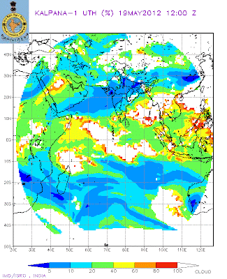
In the Bay sector, the attached UTH map shows the advance of a SWM current in the Southern regins. SW winds are geared up, but lack speed, as they are still below 20 knts. An embedded UAC is now seen in the Southern Islands area. An "in situ" low from this is expected by the 22nd (mentioned in previous blog), as the SST is now conducive at 31/32c. And which would  trigger the SWM into the remaining Bay Islands.


Western Sector: Looking at the synoptic situation today, 19th, it seems the SWM winds in the Arabian Sea, and not gaining the momentum required, still below 20 knts. 
A UAC has formed in the Arabian Sea at 8N and 65E. This may slightly disrupt the "flow of events" arrangements in completing the SWM jig-saw puzzle. May not really hamper, as I expect this system to fizzle out westwards in the face of the domonant "High" in the Sea. 


In this sector, vast improvement are seen in the Somali Current winds blowing. 
The Somali jet is Northerly now. Should attain speeds of 30 knts by now. The SST off the Somali coast is falling. Remember, the SST off the Somali coast has to drop to at least 18-20c, now at 25/26c, and create a difference from the rest of the Arabian Sea SST to form huge monsoon clouds in the central Arabian Sea. (Matter explained in previous MW).


SW winds over the primary destination, Maldives, are still below 20 knts, not enough to usher in the SWM. 
The normal, the date is 20th, but it seems the Maldives and Sri Lanka would get the SWM, albeit a weak force, by the 23rd and the 27th resp. And, I would not be too sure of its initial momentum and intensity, as the MJO wave in this region seems to be fading, and going into a weak phase from the 26th of May to the 10th of June.


ITCZ runs along the equator. Indicator: +ve
The wind map shows the ITCZ along the equator stretching from Africa upto the Bay of Bengal. This parameter, the line, should move into the 5N region around the South Arabian Sea to carry the embedded Monsoon current along with it. Normally, I do not have doubts that this will hold up the advance, as in the Bay, the ITCZ is almost at 5N.


Now, with the first meaningful heat wave getting underway in the Northern regions of the sub-continent, we can expect the seasonal low to develop in the Sindh/Rajasthan region and attain a core pressure below 1000 mb at a rapid pace. By next week, say around the 23rd, we can hope to see 998 mb in the Thar Desert region. 


Conclusion:


SWM has feebly moved into the Southern Bay Region. 


SWM will start covering the complete Bay Islands from the 23rd, and subsequently, riding on a system, reach the NE states by the 1st of June. 


SWM could be expected over the Maldives by the 23rd of May.(Normal date 20th). Over Sri Lanka around the 27th of May.


I would estimate the SWM to advance into Kerala around the dates initially estimated by Vagaries : June 3rd/4th could be the date for Kerala, but remain weakish till the 3rd week of June in coastal Karnataka and Kerala.


Initially, riding on a strongish MJO wave, the SWM could precipitate good rains in Kerala. The further current into Kerala would be "reluctant" to move ahead in a weak MJO, as International forecasters predict the MJO phase in our seas to become weak after the 10th of June. This weak phase could last till 20th of June say the forecasts. 


Nevertheless, the SWM could progessively advance into coastal Karnataka 48 hrs from 5th June. SWM could advance into interior Karnataka, Goa and S.Konkan by the 9th, and Mumbai by the 11th/13th. of June. 


After the 15th of June, I would include entire Mah and South Gujarat as covered by the SWM. I would put the SWM in a weakish phase till the 20th.  
Vagaries has put up an advance map for easy reading.


Intensity and strength of SWM in these regions will actually gain strength after the 20th of June. 
Moving into South Gujarat by 17th June and Saurashtra by 20th June.


After 24th June, a sort of "pick up" could be expected, in precipitation in the SWM regions, and further advance in the Northern plains.
Further advance will be tracked on around 1st of June.


The Monsoon forecast for the Month of June put up by Vagaries MW-4 on May 2nd ..thus holds good. Mumbai can expect about 600-650 mms in June this year.


These are my personal views and for commercial decisions consult local weather bureau.


Tuesday, May 15, 2012


Exclusive Mumbai Weather Outlook will be published on Sunday, 20th May @ 10.30pm IST: On Mumbai Page.
                                 

A low likely to form in South Arabian Sea around the 19th of May. It will be probably in the 60E and 10N area. Due to the dominant High Pressure in the Northern Arabian Sea, the system will not gain much, and will track Westwards. 


A low (B-2), gaining to depression strength, could form in the Bay. Initially, on the 23rd, it may hover around the Andaman Islands, and then intensify and move first Northwards. Later, it seems at this stage it would probably cross the Bangladesh/Myanmar coast as a depression, or a deep depression. Difficult at this stage to estimate the exact track and date.


Temperature Anomaly Last Week:


Weather Developments likely this week from Tuesday, 15th of May 


M-3 precipitates rain over Northern Pakistan on Wednesdy/Thursday. Islamabad will get light rains on these days keeping the temperatures in the 35c-20c range.


Moves into Northern India on Thursday thru Saturday. Rainfall will be light in Punjab and Haryana and moderate in Kashmir and HP and Utteranchal. 
M-3 will not move into Nepal but track NNE.


Expecting a drop in day temperatures by around 2c in Kutch and South Rajastan regions, and Balochistan and Coastal Sindh (Pakistan) on Thursday. Karachi to be around 34/35c ehile sukkur remains at 43c.


Tuesday/Wednesday and Thursday will see Moderate rains in Kerala and Coastal Karnataka. Decrease in rains in these states from Friday.
Heavy rains in NE states.


MW-6 will be published on 19th May.

Friday, May 11, 2012

Significant Developments:
1. 200 hpa jet streams finally seem to be "relenting" favourably.


2. Vertical trough, line of wind discontinuity becomes perpendicular across central India.


3. Modertae rains in Kerala and Interior TN and Karnataka as estimated in Vagaries precipitating in these regions Friday evening. showing trough alignment.


First 30c Minimums of 2012 Reported from Sub-Continent on 11th May ! 
The Places were all from Pakistan, Jacobabad, Sukkur and Bhawalnagar.
In India, Jodhpur saw a low of 30c on 11th morning...published late on Vagaries as IMD has yet to put up the max and min readings of 11th May (not put up till 10 pm IST on Friday. Info. taken from alternate source.)


Late, to some extent, this year. Mentioned in MW-5 (Vagaries).


Wednesday, May 09, 2012


Vagaries' sub-continent Forecast for Thursday,10th thru Saturday,12th on Current weather Page. 


Mumbai/Pune forecast and Mumbai Lakes Position on Mumbai Page:


Scotland:-No sking in March, But full force in June :..For related articles, See International Page and Mark's Blog.
See Inter Active Page updated with a sensational Pic from HP


Monsoon Watch 5-Arrival Dates.


As always explained, the MW parameters are to represent the progress of the developments in the Monsoon build up. On "as-is-where-is-today" basis, Vagaries calculates and forecasts the arrival date of the Monsoon. Again, these parameters are not referred in this MW for the quantum of rainfall. 


Bay factor
In the Bay sector, the cross-equatorial wind is building up across the East Indian Ocean. Strong South-West winds have suddenly developed in the South Andaman Sea, and SW winds are now required to clock 30 knts South and SW of Sri Lanka. Gauging from the the wind speed, we can expect the Monsoon to strike the South Andamans Seas by 15th of May, and the Middle Andamans by the 18th. (Almost on schedule). 


As stated, the first South-West Monsoon rains normally hit the South Andaman Sea on 12th.May. And proceed to the Middle Andamans by the 15th. By the 20th. it normally covers the Islands totally.


This year we should see a feeble Monsoon current in the South Seas by the 15th.
Onward Monsoon progress Northwards towards the NE States will have to be monitored.


The latest winds in the Bay continues to show strong winds rushing Northwards along the East coast of India, and re-curving into a Westerly flow of winds at the South Myanmar coast.


A lone pre-Monsoon low (B-1) had appeared in the region (end April) this year. SST in the Bay is now very conducive to host a low soon, in the South Andaman Seas.(See SST Map). 
Indicator : +ve


The cross equatorial Wind flow: This flow off the East African Coast, in the Western Indian Ocean, this was a bit "disrupted" previously, but has now re-formed itself fast, and is strong off the East African Coast South of the Equator. The Somali Current, is getting defined, and blowing strong! 
We will wait for the Somali coastal SST to drop further (should ideally be 18-20c). In the map, observe the difference in SST along Somali Coast and Central Arabian Sea.
The previously weak factor, the equatorial cross flow South of the Arabian Sea, is steady. 


The Mascarene highs are established at 1030 mb, are are now "pushing" the South-Easterlies from below the Equator.  


However, I feel, a good booster required for the Arabian Sea branch of the Monsoon, is still wanting, and is at least a week away. 
Indicator: Improved since MW4


Seasonal Low: With the heat factor still lacking absolute "full strength", in the Northern regions, the Seasonal Low core in the Thar Desert is now somewhat "unsteady", with a core pressure at 1002 mb, and requires to spread more westwards, rather than east. This (pulling Eastwards) is happening due to M1. 


The heat waves are still missing, with the minimums still showing vast regions in the below normal range. By this time each year, vagaries normally charts the "above 30c" minimums. But this year as yet, forget 30s, we are still barely reaching 25s in the night, with the odd one out in the NW plummeting to below 20c.
And the days ? 45c is just about getting its foothold!


To refresh, reproducing a clipping from Vagaries of 10th May 2011: "Readings of 10th May:
Hottest in Asia: Larkana (Pakistan) 48c, Nawabshah and Jacobabad  47c.
Hottest in India: 45.2c at Khajuraho, Agra  44.7c,  44.5c at Brahmapuri. 
Lows above 30c in India: Khajuraho 31c, Gwalior  30.7c, Gondia  30.4c, Kota  30.3c, Satna  30.2c. No lows above 30c noticed in Pakistan".


I only hope the below par heating and seasonal low formation in the North do not play spoilsport.


A North-South trough indicates the line of wind dis-continuity is unfavourably tilted towards the east in the Peninsula region. Normally, a perpendicular N-S trough is an ideal pre monsoon formation, and is a fore-runner for the seasonal low to stretch its presence over central India.(See Thai Met Dept Map). 


As mentioned in my MW prevoiusly, the creation of a good gradiant between Kerala pressure and Rajasthan/Sindh pressure is an absolute requirment. And that is a must for creating a pull Northwards for the Monsoon. Overall position in this parameter is improved slightly since MW 4. 
Indicator: Neutral


The ITCZ now runs along the Equator from the African coast to Sumatra Island. Normal, for it to touch the equator around the 10th. (For more read previous MW).
Indicator: +ve


The 200 hpa jet stream: 


Normally, they should be Easterlies right upto 20N by May end. This would facilitate the Northward movement of the Monsoon Current. 
Today, the Easterly jet stream is developed upto 5N.
These 200 hpa jets winds need to come upto 8N by 15th.of May at least, and then move upto 10N before 20th.May, to be in time for the Andaman Sea Monsoon arrival. But forecasting maps are slow to show this, and indicate a slow movement Northwards. 
The jet streams are far too Northwards, and are dipping South in a loop today.
Indicator: Slow, hence -ve.


Arrival Time Conclusion: 
Considering all the other parameters, with the aid of a low, (pulse from the Pacific), SWM could advance into the South and Central Bay Islands around the 15th of May. Should cover the Andaman Islands by the 20th of May. Further advance will depend on the strength of the low.


Arabian Sea branch will see the SWM advance into the Maldives region by the 22nd of May. 
Sri Lanka should get the Monsoon on its shores by the 26th. 
However, a brief halt there might result in the SWM advancing into Kerala around 3rd/4th June.


(This Monsoon chase is my personal view, and my personal analysis and deciphering is done as per my assumptions. Should not be used for commercial purposes). 


Next MW-6 will be published on 20th May evening.


Current Weather conditions and city wise forecast for the next 3 days will be published today (Wednesday) evening by 11.30 pm on Current Weather Page.
Also Mumbai Special with Lakes Position.

Sunday, May 06, 2012

Satellite Image of 8th May (Night) almost coincides with the forecast map put up earlier.


A Western disturbance, M-1, now covering Northern regions of India and Pakistan is expected to linger on till Friday. Northern Pakistan, and Northern Indian regions will continue to get pockets of Thundershowers spread out widely from North Pakistan thru Northern Indian states of Punjab,Haryana, Delhi, West U.P. and Northern M.P. Nepal too would recieve showers Tuesday thru Thursday.


Interestingly, an induced low, basically an off shoot of M-1, will form on Monday and bring rainfall in many regions of Rajasthan, MP, Interior Maharashtra from Tuesday thru Friday. Thunder Squalls with gusty winds likely in Vid, Chattisgarh, and adjoining MP.
This is a result of the Easterly 200 hpa jet streams stooping down far to the South.


Pune and Mahableshwar gets thundershowers of light intensity on Wed or Thursday. 


Also, a trough, a line of dis-continuity, will run from this low down to Karnataka/Kerala. Result: Thundershowers in interior Mah, Karnataka and kerala and adjoining TN. Rains may spill over in adjoining AP too.


What regions remains dry? Parts of W.Bengal, Gujarat and Konkan! And lower Sindh in Pakistan. 
Karachi will see some easing of temperatures , from the sizzling 42c it has been experiancing. While Sukkur will see the rise in day temperatures. Maybe some cloudy weather for Monday thru Wednesday. 
Some regions of upper Sindh may get thundersqualls too.


Mohenjodaro (Pakistan) highest at  44c, but... minimum there dips to 17c !

Wednesday, May 02, 2012

Forecast for this Weekend, 4th/5th/6th May Up on Current Weather Page.


Do not ctriticise or point fingers at IMD, or any other forecasting agencies...UK Met Office's continued bloomers proves an embarrassment for climate alarmists...See Global Warming Hysteria Page.


Analysis and Discussions on Mw-4 Put up on Inter Active Page of Vagaries:
Monsoon Watch-4. (Part -2).


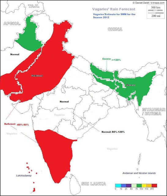
Very Briefly, explaining the Factors considered for Seasonal Forecast:


If we take into account, that the ENSO will be Neutral, but "leaning" towards a weakish El-Nino phase by, say, end August, then:


a) There will be a drop in the systems originating from the Bay. If at all there will be weak depressions just about reaching Central India and fizzling out. 
Hence could result in rainfall deficit for the NW regions, including lower Sindh in Pakistan. Central India and adjoining areas will be well covered.


b) In such a scenario, even the 200 hps jet streams would bend slightly Southwards, and the "low" at that level will be dislodged. could bring in the odd WD even in July. Could bring some heavy rainfall to Upper Pakistan regions. Hence, rainfall could be normal/excess in rest Northern Pakistan and Kashmir. Though technically they will be Monsoon rains.


c) Due to systems reluctant to track southwards, we may see lesser rains in the Southern Peninsula regions. Even the support to the west coast (South of Mumbai)may be lesser than normal. Hence, rain shadow regions in TN and interior Karnataka may be slightly deficient. Lesser gradient along the West coast will show lower rainfall in Kerala, specially in June.


d) Break monsoon situations, and winds bringing in moisture from the Bay (diverted to the NW directions) will result in excessive rainfall this season in Nepal, more so the Eastern regions. NE states of India will get continuous feeding from the Bay. (Cherrapunji seems the likely candidate for the poll).


This is a very early estimates based absolutely on the situation as it shows and stands today.  
Things, if and when they change (drastically) will be posted and Vagaries readers will be kept well informed, of any variation in the forecast.  


June Only Forecast:


Rainfall expected in Major Cities for June 2012:


Mumbai: 550-600 mms
Chennai: 50-60 mms
New Delhi: 50-55 mms
Banglore: 90-110 mms
Pune: 120-130 mms.
Surat: 250-280 mms


These are my personal views, and should be depended upon commercially or otherwise.


Check Inter Active Page for more Monsoon Information

Tuesday, May 01, 2012


Monsoon Watch - 4 (Part 1).


Forecasting Methods adopted for the Indian Monsoons:


Gowariker(1989) developed parametric and multiple power regression (MPR) models with 15 predictors for LRF of AISMR, which were later modified in 1991 to include 16 predictor parameters. The parametric model is qualitative and indicates the likelihood of the monsoon rainfall to be excess or deficient.


Thapliyal (1990) evaluated the relative performance of multiple regression, and Navone and Ceccatto (1994) have used 'feed-forward' neural network technique for the prediction of Indian monsoon rainfall with two predictors (500 hPa ridge location and Darwin SLP tendency from January to April). 


The results of a recent work by Krishna Kumar (1997) indicate that a single component accounts for about half of the total variance in the predictors


Most of the studies on LRF of Indian monsoon rainfall were based on empirical or statistical techniques till 2010. 
IITM, Pune has recently implemented the state-of-the-art coupled climate model, the Coupled Forecasting System (CFS) developed by the National Centers for Environmental Prediction (NCEP), USA. These statistical techniques range from simple correlation analysis to advanced procedures.


I still have faith, and believe in the "Gowariker Method" with 16 parameters. The results of this old but proven method has been successful. For Vagaries' forecast and analysis made in the "Arrival and quantum Monsoon Watch" series, I combine a few of them alongwith Dynamical models for a personal analysis and estimate. 


15 initial parameters from the months March, April and May are used to analysis and forecast the simulation of Indian monsoon rainfall during June to October. These initial conditions were carefully selected by experts to span the evolution of both the atmosphere and ocean.


Calculating the amount of rainfall, region wise, is of utmost importance, as SWM contributesto almost 80% of the annual total rainfall over India.
The performance of Vagaries' Monsoon Watch Quantum analysis is evaluated for the amount of summer monsoon rainfall over Indian monsoon region during June to SWM withdrawal.


The 500 hpa parameter is of importance in April. The mean latitudinal location of the 500 hPa ridge along 75°E in April over India, first identified by Banerjee (1978), is considered to be one of the most important predictors. The mid-tropospheric anticyclone over southern India migrates from 11.5°N in January to its northernmost position of 28.5°N during July. From October, the ridge starts shifting back southward. 
A more Northward location indicates better performance of the monsoon and vice versa. It also showed that the negative correlation of the March ridge was more dominant with the monsoon rainfall of the peninsular India, while the positive correlation of the April ridge was more dominant with the monsoon rainfall of Northern India.


ENSO factor in arriving at the rainfall amount is also of importance. The interface is the sea surface: that is where the transfers of water (evaporation/precipitation) and momentum occur. An accurate coupling of the fast atmosphere to the slow ocean is essential to simulate the ENSO, which in turn can simulate the interannual variability of Indian monsoon. Unfortunately, getting an accurate, or near to accurate forecast of the ENSO for the next 2 months is difficult, with no guarantee of accuracy or performance surety.


We see neutral conditions now. But, there is a possibility of a mild El-Nino event occuring as early as June/July. Now, this would result in "severe" break Monsoon condition in July. That is the last thing we want. But I would not endorse the event as yet. I would give it a 50-50 chance.


Limited pulses from the Eastern Pacific area, that is S.China sea, would mean lesser depressions and systems originating from the Bay. 
'In Situ" systems and systems from the Far east would contribute to the rainfall to the East Coast thru Central India and into Gujarat and even into Sindh (Pakistan).
El-Nino, even a mild one, would sort of restrict these pulses, and in fact encourage WDs into coming down South, more South than normal. 
But, for this, we would have to hope and pray for the Neutral ENSO conditions (presently on) to prevail and hang on till September. Again, a 50-50 chance for Neutral conditions.


Regarding the IOD parameter, recent forecasts from a few  coupled models  suggest  the possibility of development of a weak negative Indian Ocean Dipole event after July 2012.


1. Seasonal Low: Indicator: -ve


The heat is about to pick up in the Rajasthan/Sindh regions from the 3rd/4th of May, so good chance for the seasonal low to form and establish itself, at least by the 10th.Today the pressure at MSL is 1000 mb, with the core at 1000 mb. 
The sub Continent hot spots have just about touched the 44c mark (it is already Late. Refer MW-1) and should head for the 50c mark by around 16th May.


2. ITCZ: Indicator: Normal
As it is by the 10th, that we should have the ITCZ nearing the Equator. Only then would the Bay branch of the SWM could commence in the Southern Bay by the 15th of May.


3. Jet Streams: Indicator:-ve


These are streaming away in a Westerly direction above the 25N line. They are just about getting Easterly around 5N. Needs a rapid change now.


4. Cross Equatorial Winds: Indicator: Normal in Bay Branch. -ve in Arabian Sea Branch


Well established in the Bay region. SW winds, with sufficient speed hitting the S.Myanmar coasts, covering the Bay Islands with 20-30 knts, and could hearald the arrival of the SWM on time there.


Arabian Sea winds are now picking up, and rubbing the Somali coast at sufficient speed in getting the "Somali Current" established. The SST off the Somali Coast is 22c, While the required SST in First week June is 17/18c. (Required to form masses of Monsoon clouds in the warm central Arabian Sea).


The Initial Forecast for the SWM 2012, Region wise and Month wise, could go in for a revision if ENSO and Upper Winds change drastically. Possible could  put up another Revised Forecast by May End if needed.

Second Part of MW-4 with Map of Monsoon Rain Estimated Forecast region wise will be put up on 2nd May at 1 pm IST.

All my personal views and estimates. Not binding on anyone and do not use for commercial purposes.


See Current Weather Page for Today's Weather.

Forecasted East rough  Let's look into the 3rd week of March ( 17th - 21st). Mumbai : Hot weather likely for Mumbai region this week, ty...