Tuesday, May 31, 2011


With good west winds and 200 hpa easterlies, Vagaries advances SWM upto Khozhikode in Kerala on 31st May,Tuesday morning..

Overnight rain amounted to 131 mms in Kochi, and thunderstorm continuing as into dawn on Tuesday.Reports of hail too. Rains slowed down by 8 a.m.

Drizzle continues in Thiruvanthapuram into Tuesday morning.

Kozhikode had loght rains, but prevailing winds are NW.

Monday, May 30, 2011


Mumbai Weather put up on Mumbai Page

SWM advances into the Arabian Sea Islands and Northern Bay:


The Lakshdweep Islands received good rains on Monday, with Minicoy getting 40 mms and Amini Divi measuring 31 mms, accompanied by Westerly winds, in the 24 hrs ended 5.30 pm Monday.
The 200 hpa jet stream has arranged itself along the 12N line today, and huge cloud mass is seen in the Sea off the Kerala coast.
Surface winds have diverted to the South/SW direction in all areas in Southern Kerala.

Vagaries advances the SWM into the Arabian Sea Islands and adjoining sea.

As the winds along the North Kerala coast are still NW (as on Monday evening latest), they are expected to become SW and create perfect conditions for SWM to rush into entire Kerala within 12 /24 hrs.


The Eastern coast trough has shifted to the extreme North-East of the Bay, and an embedded UAC in the Northern Bay region has become persistant. With SW winds gaining speeds to 30 knts in the Bay region, including the NE region of North Andamans, and Andaman stations getting between 20-35 mms of rain, vagaries advances the SWM into the Northern bay and Andaman Islands.

These are the personal assumptions of the author done as per IMD norms.


Sunday, May 29, 2011


SWM remains weak in Sri Lanka:

SWM entered Southern Sri Lanka as a weak current (Vagaries' report) on the 26th, and still remains weak. There was little rainfall in the Southern regions today (Sunday), with Kurunegala measuring 14 mms and Ratnapura getting 11 mms.
The attached sat. image from wundermap (Sunday evening 6.30 pm) shows the SWM still restricted to the Southern half. Anticipitated by Vagaries to cover the Island by the 29th, but seeing the conditions, the advance is not possible today.


Another sat image shows the Kerala region as on Sunday evening, 6.30 pm IST. I feel, (with ref. to IMD statement), the SWM is still 24/36 hrs away. The region
had 2 days of pre-monsoon rain, as mentioned in our blog.

With regards to the Bay sector, the trough off the eastern coast is also weakening, and stationary, again, not allowing the SWM to advance further to cover the Bay Islands.

Vagaries' northern limit map of SWM remains unchanged.


For Your Information:
-Thunderstorms reported on Sunday evening from interior Goa and Dandeli regions.
-Hailstorm with thunder in Dehradun on Sunday evening, continuing till last report at 6 p.m. Rainfall measured 22 mms.
-Belgaum also is also witnessing a thunderstorm this evening. Rainfall 27 mms.

IMD advances SWM. Northern limit: AminiDivi, Kozhikode, Kodaikanal, southern half of Sri Lanka and southern half of Bay Islands.
 
.

Saturday, May 28, 2011


Monsoon Watch-9

Seasonal Low: By not deepening further, as is expected by now in the pre-monsoon days, the seasonal low seems to be staggering. The central pressure is today at 1000 mb. The gradient is weakening, and is required to get steeper in the next 2/3 days.Result of lower day temperatures in the northern plains last 3 days.The culprit ? M3.
I would not worry much on this count, as days will suddenly heat up from Sunday. (Though M4 is expected by 31st May).

A trough running down the eastern coast of India will be a fore runner in pulling up the SWM in the next 24 hrs to cover the Bay Islands, and, with the SW winds picking up there too, a larger
area of the Bay will be covered.

With the trough re-forming in the eastern regions, I expect the SWM to pull up in the NE
states around 2nd/3rd of June.


The cross equatorial winds are getting stronger off the Sri Lanka coast. Vagaries had advanced the SWM in the western and southern areas of the island on the 26th. See Sat Image .Now, with the SW winds crossing 30 knts today, the SWM can be expected to cover the
island by the 29th.


The Somali winds are strong enough now, and resultantly, the SST along the Somali
coast has dropped to 20-22c.

As explained earlier (in previous MWs), this, along with a high water temperature in the central Arabian Sea is needed to create huge Monsoon clouds in the central region. This is exactly the position today (28th). We see cloud masses in the central region, with the possibility of a system forming there by the 31st.

As seen in the sat image above, a distinctly seperate cloud mass off the Kerala coast is the developing SWM cloud. With the monsoon having arrived in parts of Sri Lanka, pre monsoon showers have
started in Kerala.

Conclusion:

SWM will cover the Sri Lanka entirely by 29th, and set up its advance into Kerala. Should hit Lakshadweep and Kerala by 2nd/3rd of June. As of now, its further advance northwards will be maintained as per Vagaries' forecast.

Bay Islands will be covered totally by 29th, albeit as a weak current. SWM likely to advance into NE regions around 3rd June.

A system will form in the Arabian Sea by the 31st of May. This should deepen a bit, maybe up to a depression strength, move north/north-west, and fizzle out before making landfall. Hence, may effect the SWM.

Mumbai: Sticking to the original forecast, Mumbai should get the first pre monsoon rains from the 2nd/3rd of June.

29th, Sunday/30th, Monday/31st, Tuesday:Partly cloudy.


1June,Wednesday: Partly cloudy with thunderheads in the eastern sky by evening. Light drizzle in some pockets.


2nd June,Thursday:Partly cloudy to cloudy. Thunder clouds in evening. Showers
in most areas of the city with lightning. Rainfall upto 8-10 mms.

Monsoon Watch-9 coming up by 11 pm tonite. Latest on the development of the SWM


Friday, May 27, 2011

On Friday, 27th May:

Highest in Pakistan:46c Nawabshah. Highest in India: Chandrapur (Mah) :44.8c. Largest departure from normal in India (day temp): Bareilly (U.P.) temp; 30.4c Dep:-10c.

Sub Continent Heat "smashed" by M4 !

Seasonal Low hanging around 998 mb !

Gradiant not enough now ! Good News is M4 is showing its back..and heating will resume from Sunday ...should not upset SWM progress...dont think so.

Meanwhile, SWM rainfall still weak in regions covered (see Vagaries Monsoon advance map), but SW winds have stiffened up to 30 knts off the coasts. In Sri lanka, rain showers in Colombo, Ratnapura and Ratmalana and Galle on this morning. Between 7 -10 mms recorded. Port Blair received 7 mms till 5.30 am on Saturday.

Male (Maldives ) measured 17 mms till today morning.


Outlook For Arabian Sea system, Mumbai and Mahrashtra:

Fortunately, developments and progress seems to be on schedule, and going as per our predictions. (Keep the Monsoon onset Dates map of Vagaries kept handy).

Yesterday, 25th May,SWM has advanced into the Maldives and west Sri Lanka, and up to middle Andamans.

Now, the pre monsoon thundershowers in interior Mah.and North interior Karnataka have started as vagaries had estimated, around 25th May. Frequency of pre monsoon thundershowers for interior Mah. will increase till the SWM onset.

Mumbai, will be partly cloudy/cloudy next 6 days. Will see pre monsoon rains/thundershowers commencing from 3rd June.

For the next few days, the SWM seems to be heading on time for the estimated dates of onset. SWM can advance into Kerala as per our set time table, by the 3rd/4th of June.

So far so good. But,I do not want to stretch my luck too much.

In case we have a system developing in the Arabian Sea, things will start moving and changing according to the "will" of the system.

Two Possibilities:

-If it forms, it will be around 31st of May. But, SWM will be on Kerala as per schedule. If the system intensifies, and remains in the mid-Arabian Sea region, monsoon, after hitting Kerala, will get diverted towards it (West).

-If the system forms, and concentrates in the western region of the sea, I do not think it will affect the Northward advance of the monsoon into Karnataka.

My views:

SWM will be ok, on schedule till striking Kerala.

A system can form in the mid sea Arabian Sea, along the 60E, around 31st May.

System, will not get to a very strong level, maybe just a depression. May move along the mid sea regions, towards the NW, away from the sub-continent, but pull up the SWM northwards along the west coast of India.

Absolutely my personal reasoning and estimates.But actualities can change.

Vagaries will keep informing of the exact developments as and when.


Putting up latest views on SWM progress and Mumbai/Mah. outlook for next week tonite by 10.30 pm


Thursday, May 26, 2011


Monsoon Advances into Maldives Region and Sri Lankan Western and Southern Areas, and Central Andamans.

The Southern and Central Andamans are receiving sporadic rains for the last 3 days. Port Blair has measured 71 mms, 57 mms rainfall for the last 2 days, i.e. 25th/26th May. Port Blair got 114 mms in the 24 hrs ended 5.30 pm on Thursday.

As on 26th May, Vagaries advances the SWM as a weak current into the regions of Maldives, Sri Lanka and up to Central Andamans.

Heavy rains lashed Colombo on Thursday morning.

Vagaries is following and adopting the norms set by IMD for Monsoon Advance. All monsoon advances announced by Vagaries is as per the norms followed by IMD, but are strictly the veiws of the blogger, and for further commercial uses IMD may be referred to.

Giving below the IMD norms for SWM advance for readers' fast and ready reference.

MONSOON ONSET NORMS OVER KERALA:

The guidelines are followed for declaring the onset of monsoon over Kerala.

1. RAINFALL

CRITERIA:- If after 10th May, 60% of the available 14 stations enlisted, viz. Minicoy, Amini, Thiruvananthapuram, Punalur, Kollam, Allapuzha, Kottayam, Kochi, Thrissur, Kozhikode, Thalassery, Kannur, Kasargode and Mangalore report rainfall of 2.5 mm or more for two consecutive days, the onset over Kerala be declared on the 2nd day, provided the following criteria are also in concurrence.

2. WIND FIELD

CRITERIA:- Depth of westerlies should be maintained upto 600 hPa, in the box equator to Lat. 10ºN and Long. 55 ºE to 80ºE. The zonal wind speed over the area bounded by Lat. 5-10ºN, Long. 70-80ºE should be of the order of 15 ? 20 Kts. at 925 hPa. The source of data can be RSMC wind analysis/satellite derived winds.

3. OUTGOING LONGWAVE RADIATION (OLR)

CRITERIA:- INSAT derived OLR value should be below 200 wm-2 in the box confined by Lat. 5-10ºN and Long. 70- 75ºE.

Northern Limit of Monsoon (NLM)

Southwest monsoon normally sets in over Kerala around 1st June. It advances northwards, usually in surges, and covers the entire country around 15th July. The NLM is the northern most limit of monsoon upto which it has advanced on any given day.


Storm in Pune; crazy winds lightning n rain lashing out City at present. Reports Vijay at 7 pm Thursday.


Wednesday, May 25, 2011


SWM advancing into Sri Lanka and Maldives:

Maldives capital Male has had a windy day, with SW winds upto 40kmph today. Frequent showers during the day guaged up 32 mms of rain on Wednesday.

Thunderstorms and heavy rains have been lashing western Sri Lanka since Tuesday night. 
Colombo had day long rains on Wednesday, and measured 66 mms till 5.30 pm. A thunderstorm lashed the city at 5.30 pm and 8.45 pm today.
SW winds have been sweeping the capital. Ratnapura measured 96 mms of rain till Wednesday evening. Ratmalana had 56 mms and Galle had 28 mms. All reported cities are from the west and south west of the island..
Vagaries has announced the possibility of a system forming in the Arabian Sea - in the first week of June.
Answering queries if it would become a cyclone, or whether the "cyclone" would have any bearings on the SWM is not possible at this stage. Over enthusiasm could be mis-leading.
A system is yet to form, and is 7 days away from getting formed. Possible strength and track is quite impossible to estimate at this stage. Any model predicting its movement will surely change it rather frequently, as things develop either way. (May not form at all).

Regular readers know, that Vagaries generally avoids changing given estimates too frequently, and makes a detour in forecast only if the weather situation forces it.
Vagaries would like to make an announcement only when its quite sure of it. It is for this reason that Vagaries could be late on some occasions.
But still sometimes, things do change within 24 hrs, and the whole scenario can rapidly take another turn.

Regards, Rajesh.

Tuesday, May 24, 2011


Highest in Asia on Tuesday:

Bhawalpur and Dal bandin (Pakistan) :45c.

Highest in India: Brahmapuri: 43.5c.

Kota at 31.6c and Bikaner at 30.9c were above 30c as the minimum in India.In Pakistan, Multan and Sibbi were at 30c as the low.

Most "unlike summer" weather for Kathmandu: With Max temperature at 28.5c and the low at 17c, its very pleasant and comfortable for this time of the year. M4 expected to bring in more rains from 26th.

Forecast for Mumbai:

Wednesday/Thursday/Friday: 35c - 28c. Real feel @ 37c.

Partly cloudy, with humidity levels at 75%. Sweaty and uncomfortable.

Replies to comments !
I have received all comments, but due to technical difficulties, blog server is not loading on blog.Not even my replies. Here are my views on every comment.

@Ron. I have put up the status of the SWM over Andaman Islands in MW-8. As per my readings, it is approaching. I have also indicated how late it is in all regions. SWM position approaching Maldives is not mentioned on any other site. Solely on Vagaries !
Typhoon Songda is moving NE. Normally can send a pulse in BoB by 8days. If M4 is active, pulse will be affected in Bay.

@Ashokbhai. Thank you-corrected.

@ anonymous. Which SST site in particular are you referring to ?

@svt. Lets see and observe. No international model has predicted any system in the Arabian Sea as yet. If true, Vagaries will be the first !

@rajkmr. Thanks for quoting from Vagaries in your comments on the KEA blog on the 22nd of May.

Some time back, I was honoured to be appointed as a "co-author" of the prestigious "Indian Weatherman" web site. A popular weather site, visited from the world over, Indian Weatherman provides a unique opportunity for weathermen from all over to interact.

Snippets and articles by Vagaries are put up on this site also.


Monsoon Watch - 8

Cross Equatorial Flow has picked up considerably in the Arabian Sea. Winds over 30-35 knts are seen gushing Northwards off the Somali Coast.

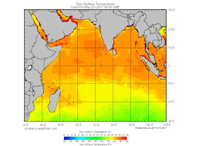
Today's SST map is reproduced here to show the Sea temperature falling along the Somali coast. It is presently around 26c. Now, this difference with the Central Arabian Sea plays a key role in cloud formations in the Central Arabian Seas. The SST along the Somali coast will rapidly fall to around 18/20c in the next 15 days.

But the current fall is sufficient to help form Monsoon clouds off the Maldives. Cloud formation near Maldives is gathering, and in next 24 hrs, wind speed along the Maldives coast is estimated at 40 mph as per the country's Met Dept.

The ITCZ has moved up a bit and is now around the 3N region south of India, and in the 5N region in the Bay sector.

SWM should set in over the Maldives within next 36 hrs, that is by the 25th/26th May. Further advance into the Sri Lanka coast is possible around 26th/27th.

The Seasonal Low seems to have got punctured. With the M3 creating an undesirable situation, we see today's pressure at 1000 mb. Not enough to create a gradient to pull up SW winds into the mainland. The day temperatures on the SubContinent Northern plains have dropped since Saturday, and restricted the day's highs to around 40c. Across in Pakistan' Sindh region, the core for the formation of the low, the highest was 47c on Monday.

M3 HAS become the "kill joy" we had NOT hoped for !

M4 is seen on the horizon, and will be into Pak/India Northern regions from 26th May. Rainfall increasing into Nepal from 27th May.


The Bay sector has been unusually weak. Its lack of systems could be attributed to M3. Strong westerly currents prevent the formation of lows to move into the bay and towards the Indian mainland. They divert the forming currents.

As SW winds should pick up speed in the next 2 days, SWM "in situ", could advance into the bay Islands as a weak current on the 26th of May.

Better before the M4 reaches the region to spoil another "party".

Conclusion: SWM advancing into Maldives by 25th (late by 5 days) and Sri Lanka by the 26th of May (late by 2 days). Similarly, SWM moving into Bay Islands by the 26th of May.(Late by 5 days).

Advance into Kerala around expected date , 3rd/4th June. But, further advance needs monitoring. Formation of a system in the Arabian Sea possible in the first week of June.

Monday, May 23, 2011

Mahableshwar receives pre monsoon showers. Shiraz informs of 12.8 mms of rain on Monday. Vagries predicted pre monsoon showers would start from 25th in Mahableshwar.

Light rain in Mumbai. Santa Cruz and Bandra areas sprinkled on Monday around 8.15 am.


Sunday, May 22, 2011


Sunday, 22nd May, 2011:

Pakistan maintains its 50c trend. Turbat topped the Asian chart on Sunday with 50c. Other hotspots were a little better, with Sibbi recording 47c, Nawabshah at 46c.

As estimated yesterday, Karachi is back to 35c.

In India, it seems the highest on Sunday was 42.3c at Machlipatnam and Gannavaram, A.P. Thats as per the available information as yet.

Anyway, most of the North Indian cities were between 35-38c, and a few stations in Rajasthan saw around 38-40c.

Its a definite M3 cooling down effect. Mild rainfall in Kullu-Manali and snowfall in high altitude peaks around the district have sent the mercury plummeting.

The weather tower installed at Dhundi near Manali indicated that the hill resort recorded minimum temperature of 12.2c on Saturday. The maximum day temperature was recorded at only 14.3c, around 10c below the normal. Kalpa was the lowest in H.P. at 4.8c. Mandi received 64 mms of rain in 24 hrs.
Rohtang pass, Deo Tibba, Hanuman Tibba, Makarved, Shikarved, Hamta Pass and adjoining peaks continued receiving more snow.

WEATHER TALK

By Mark Vogan

Global Lightning!........'On average, a plane will get struck by lightning at least once a year'.....'Global map of lightning frequency'...'Catatumbo lightning' and much more.

An informative write up on Lightning put up by Vagaries' Partner. Its a detailed long talk, but worth reading all the way. I found it very interesting and illustrative..highly recommended for weather enthusiasts and.. fulminologist...whats that ? Read the article -:)...on Mark's Blog.


Mild showers today morning around 5.30 am in South Mumbai  Mahalaxmi area and Tardeo. Measured rain 1 mm.


Saturday, May 21, 2011


Highest in India: Sheopur (M.P.): 44.8c, Jaisalmer: 44c, Bikaner: 43c.
IMD map shows a drastic change and fall in the day temperatures on Saturday. Compare with Friday, and the fall in North, NW and Central India is comparable.


Highest in Pakistan: Turbat and Lasbella: 50c.
Surprisingly, and unexpectedly, Coastal cities of Pakistan too jumped the line today. Gwadar was 48c, while Karachi soared to 44c. (Pak Met site reports of 46c in Karachi today). Incidently, the highest ever for Karachi in May is 48c.

This is a sudden jump, from the tolerable 36/37c that Karachi has been through for the last 15 days. Day temperature was 38c on Friday, and 36c on Thursday.
I noticed a slight curving of the winds around Karachi, and seems the wind shifted to NE direction. This caused the humidity to fall sharply to a low of 16%, for a coastal city ! And a sharp rise in the day temperature, resulting from winds coming from the hot interiors.

For Karachi, I do not expect another day crossing 40c. Maybe 40c on Sunday, and should come back to 38c by Monday, and then, with some moisture creeping up from the SE, some rain is on the cards on Tuesday/Wednesday. Not much though, maybe 2/3 mms per day.

Vagaries makes it to the press in Gujarat..click here

M3 active ! Massive thunder/Hailstorms in Delhi, Punjab, Haryana and H.P. bring down temperatures in the region. As a result, the temperatures in Delhi is currently (at 8 pm) at 28c, after a afternoon drop to 22c during the storm . Most of Northern plains currently around 26-28c. We had estimated a drop in days after Friday in previous blogs.Vagaries' Fear hold true.

Karachi shoots up to 46c ! Details of Saturdays temps later tonite.

via gmail.
.
W.D. to be active today (Saturday) in S.Kashmir, H.P, Punjab, Haryana, Utteranchal and Delhi. Violent hailstorms expected.

Friday, May 20, 2011

First 50c of the year !

Turbat and Jacobabad in Pakistan touched 50c today, 20th May 2011.

Sibi at 49c and Nawabshah at 48c were in line.

The hottest night in the sub-continent was at Sibbi, which saw a low of 35c on Friday morning.

In India, temperatures were highest at 46.5c (Pilani) today. Ganganagar scorched at 46c, while Kota was 45c.

Hottest night on Friday in India was at Ganganagar: 33.2c, while Kota could bottom only 31.6c.


Monsoon Watch-7 , Part -2 , -Advance, Quantum and Initial Strength.

This Watch will evaluate the progress of the SWM advance, and its estimated initial strength.


Looking at the synoptic situation today, 20th, it seems the SWM winds in the Arabian Sea and Bay sectors are hesitant, and not gaining the momentum required. SW winds over the primary destination, Maldives, are still below 20 knts, not enough to usher in the SWM. Normally, the date is 20th, but it seems the Maldives and Sri Lanka would get the SWM, albeit a weak force, by the 23rd and the 26th resp. And, I would not be too sure of its initial momentum and intensity, as the MJO wave in this region seems to be fading , and going into a weak phase from the 25th to the 4th of June.

The further current into Kerala would be "reluctant" to move ahead in a weak MJO. The MJO wave, for the Arabian Sea region is forecasted to gain inertia from the 4th of June. So, thru this wave, I would estimate the SWM to advance into Kerala around the dates initially estimated by Vagaries : June 3rd/June 4th could be the date for Kerala.

Initially, riding on a strongish MJO wave, the SWM could precipitate good rains in Kerala, and advance into coastal Karnataka 48 hrs from 4th June. Again on this wave, SWM could advance into interior Karnataka, Goa and S.Konkan by the 8th, and Mumbai by the 9th/10th.

Advance further will not be a hindrance, by the 15th, I would include entire Mah and South Gujarat as covered by the SWM.

Vagaries has put up a map for easy reading.

Intensity and strength of SWM in these regions will be good till the 23rd. After 24th June, a "slow down" could be expected, in precipitation in the SWM regions, and further advance.

The Monsoon forecast for June put up by Vagaries on May 7th, as MW-5 Part-2.... holds good.

Mumbai can expect about 650 mms in June this year.

In the Bay sector, SWM will start covering the Bay Islands from the 23rd, and subsequently reach the NE states by the 1st of June.

These are my personal views and for commercial decisions consult local weather bureau.


Thursday, May 19, 2011

Monsoon Watch - 7 (Part 2) - Quantum and initial Strength. Will be up on Friday, 20th, at 12.30 pm.

Highest in Asia on Thursday, 19th May:

Sibi (Pakistan) 49c, Nawabshah( Pakistan) 48c, Pilani( Raj.India) 47.4c, Ganganagar(India) 47.3c, Basrah (Iraq) 47c.

Latest Night Temperatures above 30c:

India: Satna 31.1c, Bikaner 31.0c, Jharsuguda 31.0c, Jabalpur 30.5c, Raipur 30.3c.

Many places in Nepal had good rains on Thursday. Amongst the heavy falls, Biratnagar measured 43.5 mms, whilst Kathmandu guaged 21.4 mms today. The temperature range on Thursday stood between 27.5c and 15.9c.Close to Vagaries' estimates -:)


Flash Snippet:
Thunderstorm in New Delhi, Rohtak, Meerut and Gurgaon now. All surrounding areas of Delhi cooling down .


.

Wednesday, May 18, 2011


The Heat's On: Readings of Wednesday, 18th May, 2011.

Dadu (Pakistan): 49c, Larkana: 48c and Sibi, Jacobabad and Turbat: 47c.

Ganganagar: 46.6c, Khajuraho: 46.4c, and several 45s.

The Lows, above 30c:

India:Satna: 32.3c, Allahbad and Jabalpur:31.4c, New Delhi (Palam) 31.1c.

Pakistan: Bhawalnagar: 31c, Sukkar and Bhawalpur: 30c.

Weekend Forecast for Mumbai:

Thu 19th/Fri 20th: 34c - 28c, the "real feel" temperature at 36c.

Sunny to Partly cloudy and hot.

Strong SW winds along the west coast from Sunday will bring in moisture from Karnataka coast northwards into Konkan

Saturday: 33c - 28c. Day time Real feel temperature at 37c.

Partial sunshine, with cb clouds covering just about 50% of the sky. A rise in humidity will be felt, and as the LI shows -3.

Sunday: 31c - 29c. Real feel temperature at 37c.

Stuffy and very humid. Cloudy, with 5 OKTA (60%) clouding. Brisque south-west breeze. A drizzle spell or two of light rain, and thundershower in vicinity by evening. Rain could be measured upto 3 mms.


Monday: 33c - 29c. Real feel day temperature will be 37c.

Partly sunny, getting more clouded in the afternoon. Light rains in some areas. Getting clear by late evening . Rain amount 3 mm. Thundershower in the vicinity.


Weekend Forecast for Pune:

Sat/Sun: 37c - 24c. Day time real feel will be 37c. Partly cloudy, with some CB clouds developing by evening. No precipitation. Average humidity at 55%, with west breeze.


See Inter action Page..interesting News sent by ananth.


Continuing from our last blog of the 15th (prior to the MW-7), we see the heating taking place, along the predicted lines (Compare map of Tuesday's day temperatures with the Vagaries Map put up on Sunday).
In Rajasthan, Ganganagar was 46.9c, Bikaner managed 45.7c, All places, from Punjab to the Vidharbha region are in the 42-45c range.

New Delhi touched 44.6c, while in Central India, Akola, Gwalior and Guna
and were 45c,Gujarat and eastern regions of India are let off lightly, as yet.(See IMD Map).


Pakistan's Sindh and Punjab region too has heated up, with the days now in the 44-47c range.
Rawalpindi soared to 43c, while Islamabad has scaled 42c today, while Karachi is maintained at 36c.

Highest in Asia on Tuesday,17th: Bhawalnagar and Larkana (Pakistan) at 47c.

Highest in India: Churu was 48.6c, Ganganagar at 46.9c and Khajuraho at 46.8c, were amongst the highest.

Nights above 30c: Pakistan: Jacobabad and Bhawalnagar at 30c.

India:Kota at night was 32.2c, Jabalpur at 31.8c, Jaipur was 31.3c, Satna 31.2c and Bikaner at 30c.

But, while the heating has commenced as anticipated, M3 is arriving.
Vagaries had estimated the system to reach Pak/India by 18th. ( thru error, it was mentioned 18th as Thursday in Sunday's blog).
Northern region precipitation from M3 will commence from 19th, and M3 will be effective in H.P./Utterakhand, Kashmir, West U.P. and Delhi region from Friday, 20th.

Pockets in Sindh will have duststorms/thunderstorms next 2 days.

I qoute and repeat from Sunday's Vagaries: "I hope these factors do not become a "kill joy" to the anticipated fast developments discussed, and halt the +ve movements of the Monsoon parameters"

Extremely heavy rainfall is possible in eastern parts of Bangladesh and adjoining Indian NE states on Thursday/Friday. Meghalaya should receive heavy rains.

Mumbai Forecast for the weekend will be up on Wednesday nite, by 10 pm.

Monday, May 16, 2011


Monsoon Watch - 7.

Seasonal Low: Indicator: Better

A core is seen in the central regions of Sindh at 1002 mb. A bit better than the last assesment, as the eastward pulling has stopped with M2 running away. The pressure at the southern the tip of India, is at 1010 mb. The gradient is being gradually created. A full fledged difference of at least 14-16 mb is required to "pull" the SWM into the North.

With the anticipated heat wave from tomorrow, 17th, (see Vagaries map put up yesterday),this parameter may get going next week.

Cross Equatorial Winds:indicator:+ve

SW winds have shown remarkable improvements in both the sectors.In the Arabian Sea sector, vast improvement are seen in the Somali Current winds blowing. Having attained good speeds of 30 knts now, the Somali jet is Northerly now, and we now should see the SST off the Somali coast falling. Remember, the SST off the Somali coast has to drop to at least 15-17c, now at 27c, and create a difference from the rest of the Arabian Sea SST to form huge monsoon clouds in the central Arabian Sea. (Matter explained in MW-1).

The South -West winds in the Southern Arabian Sea seem to have tapered a bit. From my last report, when they were speeding at an ideal 30 knts, they seem to be below that now.The wind chart shows the maximum gusts in the Northern fringe of the clock wise rotation (around the high) in the Arabian Sea, and near the Somali coast.

They better pick up and come back to 30 knts at least, to enable the SWM enter Maldives around the normal date.

In the Bay sector, SW winds are geared up, but lack speed, as they are still below 20 knts. An embedded low is now fixed in a weak trough running across from East India thru SW Myanmar in a SE axis into Thailand. An eastward movement of a "in situ" low from this trough is awaited to trigger in the SWM into the Bay Islands. Conducive SST in the Bay is need now. Currently, the waters are at 29c.

ITCZ runs along the equator. Indicator: +veThe wind map shows the ITCZ along the equator stretching from Africa upto the Bay of Bengal.This parameter, the line, should move into the 5N region around the South Arabian Sea to carry the embedded Monsoon current along with it. Normally, I do not have doubts that this will hold up the advance, as in the Bay, the ITCZ is at 5N.

Conclusion: Now, with the first meaningful heat wave getting underway in the northern regions of the sub-continent, we can expect the seasonallow to develop and attin a core pressure below 1000 mb at a rapid pace. By the end of the week, say around the 22nd, we can hope to see 998 mb in the Thar Desert region.

And with a systamatic rise in wind speed in the S.Arabian Sea, SWM clouds could form only by the end of this week near the Maldives.

SWM could be expected over the Maldives by the 23rd of May.(Normal date 20th).

Kerala would be around 3rd June, and Mumbai could see the SWM season kicking off by the 10th of June.

These later dates are subject to change, depending on the fresh developments amongst the various parameters.

There are 2 deterrents !There is a W.D.(M3) coming on the 18th, and some heavy moisture incursion along the west coast is expected around the 22nd (due to strong west-southwesterlies).

I hope these factors do not become a "kill joy" to the anticipated fast developments discussed, and halt the +ve movements of the parameters.

Bay is still a bit un-organised. The trough mentioned across the Bay should give rise to a temporary low near the Bay Islands. Thereby, I would say the SWM may enter the Southern and Central Islands around the 21st, but, i feel, as a feeble current (in the absence of a stronger system).

Monsoon Watch will be put up late tonite 


Mumbai Update:

The way things were moving till yesterday, it was anticipitated that by Monday, the "high" pressure swirl in the Arabian Sea would strengthen, and the NW winds would, moving clockwise and coming from sindh/Gujarat, sweep over Mumbai.That was the Vararies forecast put up for Monday.

NW winds were to be hot, and projected to be at 37c today, while it is 31c (at 2.30 pm now).

Today, in the Arabian Sea,barring the N.Konkan area, the situation is much in tune. We see the winds getting weak after crossing Gujarat.(925 winds map above).

The reason is this (below). Seen in the map, the 700 hpa winds around Mumbai are the "culprits". The mini vortex there has off set the 925 winds from blowing below the Gujarat coast in strength. And the vortex formed at 700 hpa caused the clouding.


Even the daily low cumulus over Mumbai are missing today.

There will be no meaningful rains in Mumbai... this spell should clear within 12 hrs..rain is expected next sunday, but it has nothing to do with this clouding..

No connection with SWM. No indication of any type on the Monsoon arrival.

MW being put up tonite.


Yesterday,s vortex along the S.Konkan coast moves a bit North, gets deeper. Unexpectedly. Creates cloudiness in Mumbai,strato cumulus types. Could form cb thunderheads in the east of Mumbai by evening. Do not expect rain in the city, save a few drops in some patches if at all.

Should fizzle out in 12 hrs due to non atmospheric support, "bumped" by a high to the NW.


Sunday, May 15, 2011


Sunday's (15th May) Readings:

Highest in Asia:Nawabshah (Pakistan): 46c,

Highest in India: Ganganagar:45.9c.

Nights above 30c: Chandrapur (Maharashtra): 30.6c, Kota; 30.0c. and Bhawalpur (Pakistan) :30c.

Rising along expected lines, but more heating needed for the SWM to arrive at Kerala at least by 3 June (as per Vagaries' estimate).

More heating is expected in the Sub-Continent plains Mon thru Thursday. (16th-20th). See Vagaries temperature Map put up forecast for Monday 16th. thru Thursday 20th.

click here for larger map


During the week, New Delhi could top 47c, places in west U.P. could reach 47c and Rajasthan could scale to 48c (Dholpur ? Ganganagar ??).

Similarly, Vidharbha hot spots may reach 47c (Chandrapur or Brahmapuri).

In Pakistan, Sindh will shoot up to 50c mid week, and Islamabd will rise to 41c. Karachi will hover around 37/38c during the week, with strong surface winds.

By Thursday, 18th, we see M3 arriving , and "cooling off" the situation to some extent (Friday onwards). As of now, i feel the extent of M3 will be precipitation in regions North of Punjab in Pakistan. In India it will be precipitation in west U.P, northern M.P, Punjab and all areas to the North.

There is more precipitation in the central regions and west coast after Friday. Forecasts for Friday and later will be discussed on Tuesday.

For Nepal, we see thundershowers holding on to some regions in central and eastern parts this week. An increase in intensity is expected from Tuesday thru Friday. Kathmandu should see upto 20 mms per day on Tuesday/Wed/Thu, with the temperatures remaing in a very pleasant range, 28c - 17c.

This month's rain total has already crossed the month's average of 116 mms. It has totalled 120 mms till Sunday, 15th May.

Neeraj has informed us of the bountiful pre monsoon showers in Nepal this year (see inter-action page).

MW - 7 will be up on Monday night.

Cyclones which have hit Mumbai head on…see Mumbai Page (Query from PWP)


Rains expected in Goa, North coastal Karnataka and South Konkan today (Sunday), for a day. Vortex shifts west.
--
via gmail.

Saturday, May 14, 2011

From Our Partner’s Blog…

WEATHER TALK, By Mark Vogan

Could last May's record 53.7C (128.3F) recorded at Mohenjo-daro, Pakistan be reached again as fierce heat builds over same region?....read the article here.

Friday, May 13, 2011

Mumbai Weather Outlook: Put up on Mumbai Page…..

Neeraj sends from Nepal….see inter action Page.

Thursday, May 12, 2011

The Hottest in Asia on Thursday was:

Turbat (Pakistan) at 48c, Nawabshah (Pakistan) at 47c, Khajuraho(India) at 45.6c.

The above 30c minimums on Thursday:Pakistan, 32c at Sibbi,

India, 31.6c at Kota, 30c at Jabalpur, New Delhi, Gwalior and Khajuraho.

The minimum temperature in Ahmadnagar today was 17.8c. (5c below normal) and Nasik was at 20c, 2c below.

Amravati, in the hot Vidharbh region was also low at 24c, while the normal night temperature there should be at 28c !

Mumbai Colaba ranged between 34.5c and 26.5c on Thursday. And S'Cruz was 33.0c and 25c on Thursday.

Forecast for Mumbai:

Friday/Saturday:

34c - 27c. Partly Cloudy, with cumulus cloud puffs.


Sunday:

35c - 27c. Windy with NW winds and partly cloudy.


Monday:

37c -28c. Very windy, at 30 knts, from NW. Dry winds will bring humidity down to 55-60%, so less stuffy. Sparsely cloudy.

On Friday (morning)…

Vagaries putting up a short note on Mumbai Weather Outlook..on Mumbai Page…

Tuesday, May 10, 2011


Readings of 10th May:

Hottest in Asia: Larkana (Pakistan) 48c, Nawabshah and Jacobabad 47c.

Hottest in India: 45.2c at Khajuraho, Agra 44.7c, 44.5c at Brahmapuri.

Lows above 30c in India: Khajuraho 31c, Gwalior 30.7c, Gondia 30.4c, Kota 30.3c, Satna 30.2c. No lows above 30c noticed in Pakistan.

Next 4 days (Wed thru Saturday). We may see fairly heavy precipitation in the NE states, sikkim and Eastern Nepal. Thundershowers in Kerala and south Karnataka.
Some change expected in peninsula from Sunday.

Strong Westerly dust raising surface winds in Rajasthan and Gujarat are likely to prevail next 3 days, and Lower Sindh region of Pakistan. This would raise the day temperatures a bit more (refer to region in Vagaries' map of yesterday).

Sindh region of Pakistan could see the year's first 50c before the end of this week.
Strong dry westerlies at around 40 kmph in Karachi will keep the day temperature within 36c. Nights however will be around 27c.
After some rain on Wednesday, Islamabad will start warming up from Thursday onwards, and can reach 37c by Saturday.

Monsoon Watch - 6.

Seasonal Low:Indicator: -ve

An interesting release has been put by by IMD on the one to one co-relation between a "coolish" April 2011 and estmate of SWM arrival and quantum. It says, in years when W.Ds have dominated, it is not necassary that it has an effect on the SWM in any way. No one-to one relationship could be observed between surface heating of northwest India during the pre-monsoon period and the monsoon rainfall, it concluded.

But, I feel, one parameter is sure to have a direct bearing. The formation of the seasonal low. It surely is dependent on the quantu of heat in the Northern plains of the sub-continent.
Frequent W.Ds during April this year, and 2 in May, have kept the day temperatures in near normal levels, and the minimum temperatures much below normal (as much as 7c) in interior Mah and Karnataka, has resulted in a delay in the formation of this low.


Today, as on 10th May, we see an area of 998 mb in Central Pakistan region. But, due to W.D. effect, the 998 mb has been elongated into the sub Himalayan areas, in U.P. This was referred to in the Vagaries on Sunday.
What we now, see is a core area developing in the Thar desert region of Pakistan, at around 998 mb. This is what we were waiting for and refering to in the previous MWs.

Sub Continent: The jig-saw puzzle of the monsoon can fit in properly in the bay and Arabian sea, but I only hope the below par heating and seasonal low formation in the north do not play spoilsport. The heating even today(Tuesday) is mediocre, with the highest in Pakistan today( 10th) at 48c, Larkana, and with only a stray 45c at Khajuraho and Agra in India.

The heat low just about touched 998 mb in a small area on the 10th. A difference of at least 16mb in the pressure is required between the MSL at Trivandrum and the pressure in the heat low to create a gradiant to pull the monsoon winds and clouds inland.

Cross Equatorial Winds: Indicator: Getting Neutral.


Strong SW winds have gained strength in the Bay. Perfect re-curving at the equator has developed, and the SW current is prominent in the Bay. But, I have postponed the SWM arriaval from the earlier estimate of 12th May (South Islands) to 16th May. NW winds are pushing away any chances of any low forming in the next 5 days.

SST in the Bay, and the Typhoon Aere may host a low in the Bay around the 16th. This could pull up the SWM in the region for the time being. I say temporarily now, as the current MJO wave might weaken considerably after 15th May, and hence do not see much future for the system in the Bay.
On the Western front too, the said MJO wave seems to be weakening after the 15th.of May. As per normal time frame, it would remain weak, in this (Arabian Sea) sector till the 4th of June.

Water SST: Indicator-ve
If we compare the SST anomaly map with that of the same time last year( shown below), we see the Arabian Sea is much cooler this year, if the same normal temperature is taken into consideration. Last year the warming trend at this time was more, and this year the same region is cooler.


However, the Somali winds as seen in the streamline map, are picking up, and a distinct cooling off the Somali coast is still to occur. I feel, the SST of the Arabian Sea vis-a-vis the Somali current and other conditions are yet to gear up for monsoon clouds to start forming in the central region, around Maldives and off the Sri Lanka coast.

The ITCZ now runs along the Equator from the African coast to Sumatra Island. Normal, for it to touch the equator around the 10th. (For more read previous MW).

Conclusion: With the aid of a low, (pulse from the Pacific), SWM could advance into the South and Central Bay Islands around the 16th of May. Further advance will depend on the strength of the low.

Arabian Sea branch will see the SWM advance into the Maldives region by the 22nd of May.However, a brief halt there might result in the SWM advancing into Kerala around 4th June.


Forecasted East rough  Let's look into the 3rd week of March ( 17th - 21st). Mumbai : Hot weather likely for Mumbai region this week, ty...