Maharashtra City Max, Min and Rainfall . Max of 1st Jan and rain during day of 1st Jan
POONA 24.4(-4.6) 14.5( 4.0)
LOHGAON 24.4(-5.6) 15.2( 3.2)
JALGAON 21.2(-8.0) 10.2(-1.4) 008.0
KOLHAPUR 23.8(-6.1) 17.8( 3.3) 000.2
MAHABLESHWAR 17.7(-8.1) 11.7(-1.3)
MALEGAON 21.0(-8.4) 16.4( 6.0)
NASIK 23.4(-5.1) 11.8( 2.1) 000.6
SANGLI 24.7(-6.3) 17.7( 4.6) 008.0
SATARA 23.0(-5.5) 15.2( 2.6)
SOLAPUR 30.3( 0.0) 18.6( 3.3)
BOMBAY 26.0(-4.5) 19.6( 0.1)
Scz 27.3(-3.8) 15.8(-1.3) ALIBAG 26.1(-3.0) 17.5( 0.2)
AKOLA 20.7(-7.9) 17.7( 4.5) 010.0
AMRAOTI 29.2( 0.5) 16.4( 2.3) 005.0
BULDHANA 18.5(-7.8) 16.3( 2.4)
Chikhaldhara in Vidarbha measured 78 mms till 8.30 am Thursday.
Parts of Baroda got drizzles last night. Bharuch is experaincing showers at 6.30 pm IST on Thursday.
Bhopal saw a high of 14.2c on New year's Day...
Gwalior saw a high of only 13c and Bhopal 15.5c on the last day of 2014
Mumbai Weather Summary...2014 (From Rohit Aroskar)...See Mumbai Page and Rohit's Page
Posted Thursday 1st Morning...Vagaries' Forecasted....
New Year Eve Rainfall in Marathwada and Western Vidharbh...
31st Rainfall in Maharashtra...
As anticipated, the Marathwada region and Western Vidharbh got the rains and hail in some areas.
In West Vidharbh, Akola recorded a heavy 39.9 mms of rain, Buldana 23 mms and Yeotmal 15 mms on 31st. In Marathwada, Nanded saw 17 mms and Parabhani and Aurangabad 4 mms.

In Aurangabad, the rain started after the celebrations were over, around 1.30 am on 1st January, saving the New Year.
Nasik and Nagpur got traces of rain. Celebrations from being a damper.
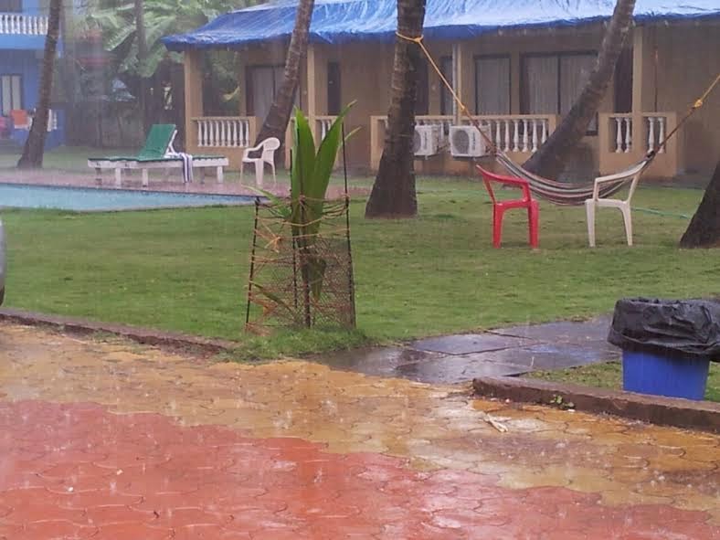
Some regions of Goa too got showers. Vagarian RK Chaudhary informs of rain on 31st and sent this pic.
More later as we get more figures...
---------------------------------------------------------------------------------------------------------
Tuesday Night drizzles in Aurangabad...Mumbai gets partly cloudy. Predicted rains ( as given below in Monday post) on schedule in Marathwada and Madhya Maharashtra. Extending to West Vidharbh. Mumbai will get cloudy.
Mahableshwar Wednesday Morning Pic sent by Shiraz

BB-15 has tracked NE to 14N 86E...and likely to track NE and weaken due to resistance.Rains along Odisha coast and West Bengal coast.Decreasing from 1st.
Chennai rains decrease. Getting average 55-60 mms in 2 days as expected.
**** In the New Year, Vagaries is planning a well attended meeting. It is (almost) compulsory to attend this meeting. .
The Meeting is on 10th January, 5 pm, and the venue is in South Mumbai.
Please confirm on blog (comments) as early as possible, as I would like to see maximum attendance. All Vagarians from any place in India or abroad are welcome...
All must confirm .(as yes) by 4th January latest..****
--------------------------------------------------------------------------------------------------------------------------

Rainfall of Chennai during Monday 29th Daytime:
Posted Sunday 28th Night:
BB-15 !The sysytem now as a Low at 7.7N and 84E, is around 1006 mb. Seeing the behaviour of the upper level winds, I expect this system to deepen stage wise to depression and track towards the TN coast. BB-15 is then expected, after tracking along the coast, to weaken after Monday and fizzle out around 15N in the Bay.
29th December ; Heavy to Moderate Rainfall is expected : Along the North TN Coast. ( Chennai: Around 40-45 mms 29th Morning- 31st Morning).
Light rains in Central TN.
30th : Heavy to Moderate Rains in Coastal AP. Moderate Rains in Coastal Odisha, TN and Kerala. Drizzles in Bangalore.
New Year EVE: 31st December: Heavy Rains in Coastal AP/Odisha. Vizag: Around 40 mms 30th morning-1st Morning). Coastal West Bengal gets heavy showers in many parts. Kolkata will gat a wet New Year Eve with showers in the evening.
Moderate Rains in Interior Odisha and Parts of South Chattisgarh (Raipur: Upto 5 mms)).
Light showers in Aurangabad , Ahmednagar, Jalna and Western Vidarbha (Akola). (Rains in Central India due to an inland trough ). Drizzles in Bangalore.
Very Cilly Night with around freezing temperatures in Punjab/Haryana, parts of NCR and Rajasthan.
Mumbai will be pleasant and windy in the evening. Low at Santa Cruz around 16c and 19/20c at Colaba. Partly cloudy next few days after the 1st.
Goa will be partly cloudy with light showers in the night or 1st morning.
Pakistan Northern plains and Sindh to face very cold temperatures from 31st for 2/3 days. Around freezing in Sindh plains and Punjab.
New Year: 1st January 2015: Heavy Rainfall in Coastal West Bengal and adjoining Odisha. Kolkata gets showers in the day. Around 10-15 mms on 31st and 1st
Moderate to light showers and hails in Marathwada (Aurangabad : Around 20 mms in 2 days. Very cold day)), West Vidarbha (Akola), North Maharashtra (Hails) (Pune/ Nasik), Interior Karnataka (Belgaum) ( Bangalore: Showers on 1st around 15 mms in some parts), Hyderabad, Parts of South Gujarat Coast (Surat: Upto 3 mms), Baroda).
Cold Wave in all of Northern regions continue and intensify from 2nd January. Gujarat and Kutch get cold from 1st January.
As we had forecasted, the 200 hpa jet streams have taken the plunge, and dipped Southwards. Though earlier than forecasted by 1/2 days.
Cold Conditions in NW India and Pak Punjab: The forecasted freezing conditions prevailed over this region from 28th Morning itself.
Some Low temperatures as on 28th Morning. List (prepared by Rohit Aroskar):
 Panchmarhi dropped to -0.5c
In Pakistan, Islamabad dipped to 0c, Lahore to 2.7c.
POONA 24.4(-4.6) 14.5( 4.0)
LOHGAON 24.4(-5.6) 15.2( 3.2)
JALGAON 21.2(-8.0) 10.2(-1.4) 008.0
KOLHAPUR 23.8(-6.1) 17.8( 3.3) 000.2
MAHABLESHWAR 17.7(-8.1) 11.7(-1.3)
MALEGAON 21.0(-8.4) 16.4( 6.0)
NASIK 23.4(-5.1) 11.8( 2.1) 000.6
SANGLI 24.7(-6.3) 17.7( 4.6) 008.0
SATARA 23.0(-5.5) 15.2( 2.6)
SOLAPUR 30.3( 0.0) 18.6( 3.3)
BOMBAY 26.0(-4.5) 19.6( 0.1)
Scz 27.3(-3.8) 15.8(-1.3) ALIBAG 26.1(-3.0) 17.5( 0.2)
AKOLA 20.7(-7.9) 17.7( 4.5) 010.0
AMRAOTI 29.2( 0.5) 16.4( 2.3) 005.0
BULDHANA 18.5(-7.8) 16.3( 2.4)
Chikhaldhara in Vidarbha measured 78 mms till 8.30 am Thursday.
Parts of Baroda got drizzles last night. Bharuch is experaincing showers at 6.30 pm IST on Thursday.
Bhopal saw a high of 14.2c on New year's Day...
Gwalior saw a high of only 13c and Bhopal 15.5c on the last day of 2014
Mumbai Weather Summary...2014 (From Rohit Aroskar)...See Mumbai Page and Rohit's Page
Posted Thursday 1st Morning...Vagaries' Forecasted....
New Year Eve Rainfall in Marathwada and Western Vidharbh...
31st Rainfall in Maharashtra...
As anticipated, the Marathwada region and Western Vidharbh got the rains and hail in some areas.
In West Vidharbh, Akola recorded a heavy 39.9 mms of rain, Buldana 23 mms and Yeotmal 15 mms on 31st. In Marathwada, Nanded saw 17 mms and Parabhani and Aurangabad 4 mms.
In Aurangabad, the rain started after the celebrations were over, around 1.30 am on 1st January, saving the New Year.
Nasik and Nagpur got traces of rain. Celebrations from being a damper.
Some regions of Goa too got showers. Vagarian RK Chaudhary informs of rain on 31st and sent this pic.
More later as we get more figures...
---------------------------------------------------------------------------------------------------------
Tuesday Night drizzles in Aurangabad...Mumbai gets partly cloudy. Predicted rains ( as given below in Monday post) on schedule in Marathwada and Madhya Maharashtra. Extending to West Vidharbh. Mumbai will get cloudy.
Mahableshwar Wednesday Morning Pic sent by Shiraz
BB-15 has tracked NE to 14N 86E...and likely to track NE and weaken due to resistance.Rains along Odisha coast and West Bengal coast.Decreasing from 1st.
Chennai rains decrease. Getting average 55-60 mms in 2 days as expected.
**** In the New Year, Vagaries is planning a well attended meeting. It is (almost) compulsory to attend this meeting. .
The Meeting is on 10th January, 5 pm, and the venue is in South Mumbai.
Please confirm on blog (comments) as early as possible, as I would like to see maximum attendance. All Vagarians from any place in India or abroad are welcome...
All must confirm .(as yes) by 4th January latest..****
--------------------------------------------------------------------------------------------------------------------------
Rainfall of Chennai during Monday 29th Daytime:
=======================
in mm
in mm
Minjur - 96 Puzhal Agro - 91 Ennore - 85 Puzhal - 65 Madhavaram - 64 Tharamani - 64
Nungambakkam - 54 Anna Univ - 42 Mylapore - 40 Sathyabama Univ - 37 Poonamalle - 36 Avadi - 35 Kolapakkam - 33 Meenambakkam - 29 (From Pradeep)
Nungambakkam - 54 Anna Univ - 42 Mylapore - 40 Sathyabama Univ - 37 Poonamalle - 36 Avadi - 35 Kolapakkam - 33 Meenambakkam - 29 (From Pradeep)
Posted Sunday 28th Night:
BB-15 !The sysytem now as a Low at 7.7N and 84E, is around 1006 mb. Seeing the behaviour of the upper level winds, I expect this system to deepen stage wise to depression and track towards the TN coast. BB-15 is then expected, after tracking along the coast, to weaken after Monday and fizzle out around 15N in the Bay.
29th December ; Heavy to Moderate Rainfall is expected : Along the North TN Coast. ( Chennai: Around 40-45 mms 29th Morning- 31st Morning).
Light rains in Central TN.
30th : Heavy to Moderate Rains in Coastal AP. Moderate Rains in Coastal Odisha, TN and Kerala. Drizzles in Bangalore.
New Year EVE: 31st December: Heavy Rains in Coastal AP/Odisha. Vizag: Around 40 mms 30th morning-1st Morning). Coastal West Bengal gets heavy showers in many parts. Kolkata will gat a wet New Year Eve with showers in the evening.
Moderate Rains in Interior Odisha and Parts of South Chattisgarh (Raipur: Upto 5 mms)).
Light showers in Aurangabad , Ahmednagar, Jalna and Western Vidarbha (Akola). (Rains in Central India due to an inland trough ). Drizzles in Bangalore.
Very Cilly Night with around freezing temperatures in Punjab/Haryana, parts of NCR and Rajasthan.
Mumbai will be pleasant and windy in the evening. Low at Santa Cruz around 16c and 19/20c at Colaba. Partly cloudy next few days after the 1st.
Goa will be partly cloudy with light showers in the night or 1st morning.
Pakistan Northern plains and Sindh to face very cold temperatures from 31st for 2/3 days. Around freezing in Sindh plains and Punjab.
New Year: 1st January 2015: Heavy Rainfall in Coastal West Bengal and adjoining Odisha. Kolkata gets showers in the day. Around 10-15 mms on 31st and 1st
Moderate to light showers and hails in Marathwada (Aurangabad : Around 20 mms in 2 days. Very cold day)), West Vidarbha (Akola), North Maharashtra (Hails) (Pune/ Nasik), Interior Karnataka (Belgaum) ( Bangalore: Showers on 1st around 15 mms in some parts), Hyderabad, Parts of South Gujarat Coast (Surat: Upto 3 mms), Baroda).
Cold Wave in all of Northern regions continue and intensify from 2nd January. Gujarat and Kutch get cold from 1st January.
As we had forecasted, the 200 hpa jet streams have taken the plunge, and dipped Southwards. Though earlier than forecasted by 1/2 days.
Cold Conditions in NW India and Pak Punjab: The forecasted freezing conditions prevailed over this region from 28th Morning itself.
Some Low temperatures as on 28th Morning. List (prepared by Rohit Aroskar):
Panchmarhi dropped to -0.5cIn Pakistan, Islamabad dipped to 0c, Lahore to 2.7c.


