Sunday, March 31, 2019

Importance of Monsoon Forecast for India:

Indian economy is basically agriculture based, and agri business and economy depend a lot on the South West Monsoon. Agriculture contributes a major part to the GDP.
Hence, getting information and forecast of the Monsoon to the farmers and concerned departments well in advance is of prime importance. The agri industries need to plan cropping patterns and farmers need to plan purchase and storage of seeds and fertilisers.


Now, IMD issues its first SWM forecast around mid April. The April forecast indicates the likely amount of rain throughout India , on the whole, and does not detail its distribution region wise. 
A forecast of regional distribution is necessary for water management and reservoir capacity storage. 
The second forecast and rain estimate is issued in June. By that time, sowing is already complete, and an adverse situation could be disastrous. Saving water stressed seedlings becomes a priority with urgent irrigation. One Fourth of the SWM is over by then.


Vagaries' Views:

The SWM forecast should be issued earliest by beginning April. It could be made by analysing the weather parameters developing as on that date in early April, and subsequently monitor the developments as they happen and issue comments on how the monsoon is likely to progress.  The  Monsoon Watch series in Vagaries begins with this concept..and charting the progress periodically, the Monsoon Watch Series indicates the +ves and the -ves in the ensuing progress. 
Initially Vagaries (MW Series) forecasts only the arrival date. And that is of prime importance. A belated advance could be fore warned, and help the farmer in delaying the sowing and saving his crops. Or later in the season, a prolonged withdrawal could be bad for the crops too, and should be forecasted and informed early. 


The quantum is taken up later on.
Though a proper estimate of quantum of rain and regional distribution must be estimated. If, for example, we have 120% of the normal precipitation, that is 20% excess, in say the western state of Gujarat, and say, 80% normal, or 20% deficient in another state, IMD would declare a "normal" monsoon. That is because it takes the figures from the country as a whole. This, I feel depicts a wrong picture.

The most dangerous, or risky, is the " break Monsoon" in the middle of the season. This has to be estimated and informed as correctly as possible, as it holds the key to proper crop and water planning.
In such cases the agriculture ministry must be prepared to support proper irrigation and supply in July or August.
For such fore warnings, the IMD issues a forecasted estimate by the time the Monsoon is half over.

Now, recently,The Japanese Agency for Marine Earth Science and Tech. has forecast below normal rains for Jun/July /Aug 2019, and another International Research Institute IRI at Columbia, have forecasted a near normal SWM for 2019. 

Whether true or false, our Met Department should take note of this seriously, and be prepared with the necessary steps to be taken. We just cannot wait till the IMD issues its "vague" forecasts. 


IMD maintains that it (SWM) cannot be forecasted so early, and that the Indian Monsoon system is too complicated. But let us understand, these foreign agencies also have a track record.


We cannot take risks with such an important event (SWM). An event that makes or breaks Indian Agriculture and Economy.

Friday, March 29, 2019

Tuesday, March 26, 2019

Posted Tuesday 26th March:

Bureau of Meteorology (Australia) & NOAA ENSO Alert System Status: 25th March 2019

The El Niño–Southern Oscillation (ENSO) is currently neutral. The Bureau's ENSO Outlook has moved to El Niño ALERT.
Tropical Pacific sea surface temperatures have touched on El Niño thresholds for the past three weeks,

This means the chance of El Niño developing in 2019 has increased to approximately 70%, around triple the normal likelihood.

Equatorial sea surface temperatures (SSTs) are above average across most of the Pacific Ocean.
The pattern of anomalous convection and winds are consistent with El Niño.
Weak El Nino conditions are likely to continue through the Northern Hemisphere spring 2019 (~80% chance) and summer (~60% chance).

The latest weekly SST departures are:
Niño 4     0.9ºC
Niño 3.4  1.1ºC
Niño 3     0.9ºC
Niño 1+2 0.2ºC

During the last four weeks, equatorial SSTs were above average in the central and east-central Pacific Ocean. SSTs were below average around Indonesia.

In the last two months, positive subsurface temperature anomalies have persisted across most of the equatorial Pacific Ocean.
Negative subsurface temperature anomalies have weakened east of 100ºW.

The ONI is based on SST departures from average in the Niño 3.4 region, and is a principal measure for monitoring, assessing, and predicting ENSO. Defined as the three-month running-mean SST departures in the Niño 3.4 region.

El Niño: characterized by a positive ONI greater than or equal to +0.5ºC. La Niña: 

characterized by a negative ONI less than or equal to -0.5ºC. 
By historical standards, to be classified as a full-fledged El Niño or La Niña episode, these thresholds must be exceeded for a period of at least 5 consecutive overlapping 3-month seasons. CPC considers El Niño or La Niña conditions to occur when the monthly Niño3.4 OISST departures meet or exceed +/- 0.5ºC along with consistent atmospheric features. These anomalies must also be forecasted to persist for 3 consecutive months.

The most recent ONI value (December 2018 – February 2019) is +0.8ºC. 


The 30-day Southern Oscillation Index (SOI) has been steady over the past two weeks, remaining within El Niño territory. The SOI value for the 30 days to 17 March was −13.3. However, the 90-day SOI is still well within neutral territory at −5.1.

Sustained negative values of the SOI below −7 typically indicate El Niño while sustained positive values above +7 typically indicate La Niña. Values between +7 and −7 generally indicate neutral conditions.

Monday, March 25, 2019

Posted Monday 25th March:

Severe Heat in Mumbai ! Mumbai Scruz touched 40.3c, above normal by 7c, qualifying as a "Heat Wave"
Low Humidity was observed in Scruz, with Hygrometer showing between 13%-15% as the driest period...Unusual for this coastal metropolis.
Pune was 40.2c and Mahableshwar 34c.(Check last year , same day temps ! here...)


Data compiled by Vagarian Abhijit and Map by Vagarian Tejas. Special Thanks to them


The severe temps expected to remain around 38/39c at Scruz on Tuesday, and then some relief as the day temperatures fall to around 34c from Wednesday...Convective clouding expected on Wednesday/Thursday.
Some convective thunder showers expected in South Madhya Maharashtra on Tuesday and Wednesday (Kolhapur/Solapur/Sangli/Satara/Miraj), and in N.I. Karnataka.

Thursday, March 21, 2019

Posted Thursday 21st March....

A gradual rise in day temperatures from Saturday will be seen in K
North Konkan (Including Mumbai) and Southern coastal Gujarat.  
Temperatures will rise in Vidharbh, Marathwada and Telengana.

Mumbai: Mumbai can bid adieu to the pleasant "mild Mumbai" weather from Saturday.23rd. At Mumbai Scruz, a gradual rise will see the mercury rising (from the present 31c) to 34c by Saturday, 36c on Sunday 24th and 38c on Monday 25th and Tuesday. During the peak heat on Monday/Tuesday, Colaba can touch 36c.
Very windy on Sunday and Monday evening. Nights will also rise to warmer temperatures in Scruz to around 22c.
A change of winds to NE, and expecting a delay in the cooler sea breeze  will shoot the mercury upto these levels.
Outer townships like Panvel, Navi Mumbai, Badlapur and Kalyan will experience heat wave on Monday/Tuesday with the day reaching 40c or above.

Pune: Warming up from Saturday, with the Sunday mercury rising to 38c and Tuesday possibly chances reaching 39/40c.

For those wanting to escape this heat...Hill Stations Like Lonavala (34/35c) and Mahableshwar (33/34c) will be hot this weekend. 
Surat: A gradual rise will see Surat touching 40c by Monday. Vadodra or Bharuch can also beat Surat in reaching the first 40c (Monday)  in Gujarat.

Heat likely to subside after Wedneesday 27th.

Tuesday, March 19, 2019

Posted Tuesday Evening 19th March:

See Mumbai Page for Latest Mumbai/Pune Weather Update


Equinox And Super moon This Week

 | (Alabama Weather Blog)

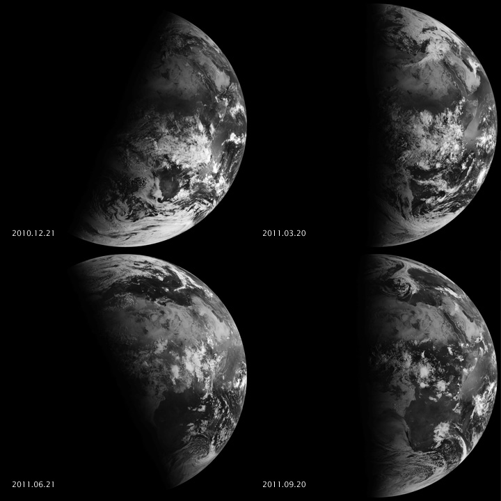
The Sun is directly over the equator during the equinoxes (right)
The March equinox arrives on Wednesday marking the beginning of astronomical spring in the northern hemisphere. Since this is measured by Earth’s trip around the Sun, it occurs at the same instant in all time zones. This is when the Sun is directly over the equator. That sub solar point continues moving northward until it is directly above the tropic of Cancer at the June solstice.
Completely unrelated to the coming equinox, the Moon reaches perigee or the closest point in its orbit to Earth on Tuesday March 19 when it is just 359,381 km away. It will be fully unlimited on Thursday the 21st having only receded by a little more than a thousand miles. That’s good enough for government work and a super moon.
This doesn’t happen every month because the moon’s orbital period, aka anomalistic month, is 27.55 days while the time it takes to go from full moon to full moon, aka synodic month, is 29.53 days.
Just go out and enjoy the big beautiful Moon, especially near moon rise or set when it will look its biggest.

Saturday, March 16, 2019

Maharashtra temperatures on 16th March... Nights are still comfortable as in March

Data provided by Shri Hosalikar (RMC Mumbai) 

Thursday, March 14, 2019

Global Impacts of ENSO Reach into the Stratosphere

(from Earth and Space News)

El Niño events have significant global impacts on weather and climate, but these reach up into the stratosphere, beyond the troposphere where most of Earth’s weather takes place.
By , and 
El Niño–Southern Oscillation (ENSO), the atmosphere–ocean coupled phenomenon associated with multi-year variations in the sea surface temperatures in the tropical Pacific, can lead to extreme changes in weather around the globe through so-called teleconnections.
ENSO teleconnections extend into the stratosphere, the layer of the atmosphere above the troposphere where most of Earth’s weather takes place. Variability in the stratosphere can also influence surface weather, both in the tropics and in the polar and midlatitude regions.
A recent paper in Reviews of Geophysics describes the observational and modeling work over recent decades that has increased our knowledge about how ENSO alters the conditions in the stratosphere from the tropics to both poles. Here, the authors of the paper give an overview of our understanding and outline the research challenges that remain.
How do El Niño events affect the stratosphere?
During the warm phase of El Niño, increased atmospheric convection in the tropical Central Pacific drives large-scale atmospheric waves that influence weather far from from the tropics. These waves can amplify vertically into the stratosphere, which strengthens the equator-to-pole circulation in the stratosphere (the Brewer-Dobson circulation), enhancing the upward motion in the tropics and downward motion at the poles in the stratosphere. This circulation change is associated with a cooling of the tropical lower stratosphere, and a warming of the polar regions in both hemispheres. The anomalous wave propagation also weakens the stratospheric polar vortex, leading to a higher probability of so-called sudden stratospheric warming events, which can induce cold air outbreaks over Europe.
The changes in tropical heating and convection also influence the tropical stratosphere. In the lower tropical stratosphere, a cooling is observed along with a decrease in ozone during El Niño, with strong zonal asymmetries, especially in the lowermost stratosphere. The wind anomalies associated with the tropical stratospheric Quasi-Biennial Oscillation (QBO) tend to propagate downward faster during El Niño than during La Niña.
El Nino impacts in the troposphere and stratosphere
Global impacts in the troposphere and stratosphere during El Niño events. Credit: Domeisen et al. [2018], Figure 4
How are stratospheric processes differently affected during La Niña events as compared to El Niño?
During La Niña events, the opposite stratospheric response is observed in most regions, but the response is not symmetric between El Niño and La Niña for all observed impacts and regions. For example, the observed frequency of Arctic sudden stratospheric warmings is similar for El Niño and La Niña winters rather than being opposite.
Even in regions where the opposite response is observed, La Niña and El Niño events of a similar strength (as measured by the magnitude of the sea surface temperature anomalies in the tropical Pacific) do not necessarily produce teleconnections of equal magnitude for both the troposphere and the stratosphere.
It is not clear whether some of these observed differences in La Niña and El Niño teleconnections arise from the asymmetric forcing in the tropical Pacific, or if they reflect internal atmospheric variability affecting the teleconnections.

Monday, March 11, 2019

Posted Tuesday 12th: Effect of M-2 

from the Tribune
Biting cold wave conditions further aggravated in Himachal as tribal areas and other higher hills received fresh snowfall while severe storm lashed mid and lower hills accompanied by rains and sleet.
Icy winds accompanied by sharp showers lashed state capital Shimla forcing people to stay indoors while adjoining tourist resort of Kufri received light snowfall.
Higher reaches in Lahaul & Spiti, Kinnaur, Chamba and Kullu received fresh snowfall while lower hills of Mandi, Bilaspur, Hamirpur, Kangra and Solan had widespread rains causing sharp fall in temperature.
Kalpa and Manali received 5 cm and 3 cm of snow while Rohtang Pass and Kothi had 30 cms of snow. Chamba was the wettest in the state with 19 mm of rains followed by Tissa 16 mm, Sundernagar 10 mm, Manali 9 mm, Dalhousie 8mm, Bhuntar 7mm Shimla and Sarahan 5 mm.
The maximum temperatures dropped from 25.2 degree to 18.3 degree C at Una. Keylong recorded the minimum temperature at minus 5 degree while Kalpa, Kufri and Manali recorded a low of minus 0.6 degree, 2.5 degree and 3.6 degree, respectively.
Posted 11th March Monday

Western Disturbance M-2 (See last post below for details)


Friday, March 08, 2019

Posted Friday Evening 8th March:

March Heat Wave in Tamil Nadu and Southern A.P.

Maximum Temperatures: Highest Maximum Temperature: Madurai, Salem, Karur Paramathi and Tirupathi airport: 41.0C

Departure from Normal: 
 
Maximum Day Temperatures likely to gradually increase by 2/3c in Central and Western India this weekend (Saturday/Sunday).
Western Disturbance M-2 will be over Northern Mountains and NW India on 11 th  March (Monday). Rains likely in Kashmir, H.P, and lighter rains in Punjab, Haryana and Delhi on Monday.

Mumbai: Weekend will be warm around 33c in the day and 21c at night. But Eastern Outer Townships like Badlapur, Karjat, Thane and Panvel likely to heat up to 37/38c this weekend.
Pune: Likely to be warm/hot this weekend around 35/36c. Nights around 16/18c.


Forecasted East rough  Let's look into the 3rd week of March ( 17th - 21st). Mumbai : Hot weather likely for Mumbai region this week, ty...