Vagaries© of the weather.blog written by rajesh kapadia & co-authors concentrating on meteorology of the Indian sub continent and extreme world weather since 55 years For Any Information taken from here, due credit must be given to Vagaries.
Thursday, June 30, 2022
June. Cherra 5343 mms
Total from Jan..10213 mms
Mawsynram June 5429 mms
Total from Jan 10684 mms
2022...Mumbai Rainfall..
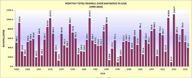
Santa Cruz 292 mms .(-245)
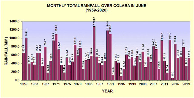
Colaba 361 mms (-181)
Compare with last 10 years June rainfall
2012 299 mms, 2013 1030 mms
2014 87 mms, 2015 1106 mms
2016 697 mms, 2017 523 mms
2018 792 mms, 2019 515 mms
2020 395 mms, 2021 961 mms.
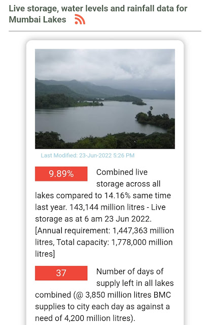
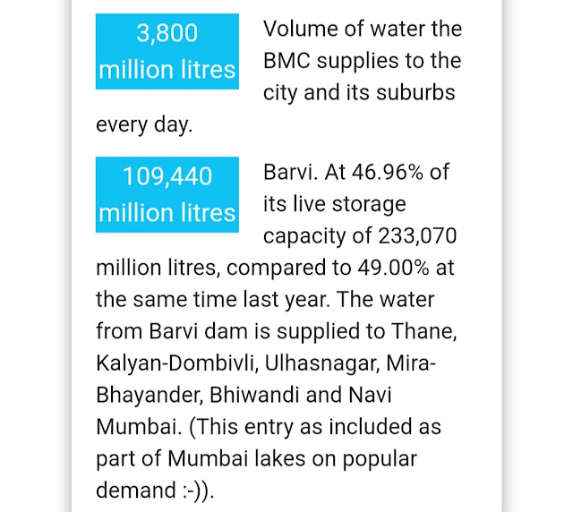
Lakes today are very Low at 10% Storage only (17% Last year this Date)
Mumbai: Outlook:
Next 3/4 days, from 30th-4th July, Mumbai can see a improvement in rain intensity, maybe to the extent better than the last month's rainfall frequency.. Frequent showers with heavy falls expected in the next 3/4 days till Monday 4th.July. Lake levels will go up from10%.
With negative IOD, we see small scope of major improvement in Mumbai rains , in the first 10 days of July. There could be some meaningful change after the 10th of July.
Marathwada (Aurangabad) and Madhya Maharshtra (Pune/Nasik)will not see much increase in rainfall next 4/5 days. The intensity of rains will not show major increase, but scattered showers will continue.
मराठवाडा (Aurangabad)आणि मध्य महाराष्ट्रात (Pune/Nasik) पुढील ४/५ दिवस पावसात फारशी वाढ होणार नाही. पावसाच्या तीव्रतेत मोठी वाढ होणार नाही, परंतु विखुरलेल्या सरी सुरूच राहतीलWednesday, June 29, 2022
Rain and Thundershowers across the Himalayan foothills and Gangetic plains today early morning!
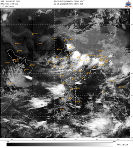
Today 29th June, 6 am satellite imagery and radar indicated good rain and thundershower activity along Himalayan foothills of Punjab, Himachal Pradesh, Uttarakhand and across the plains of Uttar Pradesh and Bihar.
Monsoon trough is establishing over north India and arrival of monsoon is expected in Uttar Pradesh and parts of Himalayas today.
Saturday, June 25, 2022
Monsoon outlook till Tuesday 28th June:
Mumbai: The usual heavy Mumbai rains still elusive. Light to moderate showers expected in Mumbai and neighbourhood till Tuesday, intensity may vary across different parts, shouldn't cause travel delays. Widespread heavy rain still eludes the catchment areas and western Ghats around Mumbai.
Pune: Chance of only drizzles/ light rain for next 3 days.
North Madhya Maharashtra (Dhule/Jalgaon) and western Vidarbha (Akola/Amravati) could see some moderate rain/thunderstorms with localized heavy rain.
Marathwada: No major change in pattern. Light to moderate rain/Thundershowers in parts of Aurangabad/Jalna/Nanded districts, with localized heavy in few areas.
मराठवाडा: हवामानात सध्याच्या परिस्थितीपेक्षा विशेष बदल अपेक्षित नाही आहे. हलका ते मध्यम पाऊस औरंगाबाद/जालना/नांदेड येथे पडू शकतो. काही भागात गडगडाटासह थोडा जोरदार पाऊस पडण्याची शक्यता आहे.
Konkan: Occasional moderate showers across Raigad, Ratnagiri and Sindhudurg districts. Some regions can get heavy rain till tomorrow 26th June. Intensity may increase after 28th June.
Goa: Occasional moderate showers likely. No continuous heavy rain expected. Intensity could start increasing from Tuesday 28th June.
Gujarat:
No widespread heavy rain is likely. Patchy thunderstorms expected in Saurashtra region as well as Surat-Valsad belt.
Vadodara and Ahmedabad region have some chance of getting thunderstorms on 27-28 June.
Monsoon advancing into Madhya Pradesh, eastern and central parts of Uttar Pradesh and up to Uttarakhand by 28-29th June, mostly as a moderate intensity current.
Further advance into east Rajasthan and Delhi NCR likely by 30th June.
Friday, June 24, 2022
Tuesday, June 21, 2022
Strange cloud over Caspian Sea..See Weather Knowledge - 44
21st June... Finally UAE reached 50°+
Highest temperature for today
Bada dafas in abu dhabi
50.7°C
Owtaid in abu dhabi
50.1°C
Al Jazeera in abu dhabi
49.6°C
Hamim in abu dhabi
49.4°C
Umm azimul in abu dhabi
49.1°C
Abu Dhabi IA
45°C
Dubai IA
41°C
Sharjah IA
40°C
Technical Note:
Possible weather developments for this week: 21st -25th
The currently on Westerly surge along north konkan and south Gujarat coast to weaken from 22nd June.
An elongated UAC in the east-west shear zone will develop, causing thundershowers along Maharashtra Ghats (Igatpuri to Mahabaleshwar stretch), Madhya Maharashtra, Marathwada and Vidarbha regions mainly during 22-23 June. These thundershowers could be heavy in some parts.
The UAC could possibly organize and strengthen further, persisting along/off North konkan coast.
There exists possibility of some localized heavy rains in Ratnagiri/Raigad districts during 23-25 June.
South konkan/Goa could continue getting rain as westerlies likely remain strong till around 700 hPa level in these regions.
The Eastern arm of Monsoon is turning towards Gangetic plains after causing extremely heavy rains in parts of northeast India. But it is not very active, and would cause some rain/thundershowers in parts of West Bengal, Odisha, Jharkhand, Bihar East MP, Chhattisgarh in next 3-4 days. We still await the formation of a monsoon low/depression in the Bay/east coast.
Monsoon arrival not expected in Delhi NCR region till at least 25th June.
Sunday, June 19, 2022
Mumbai will get some heavy showers on 20th & 21st...with frequency of Showers increasing.; Approximate Rainfall variable in parts of City 60-100 mms/Day.
22nd slight decrease in rains ....
Pune : Monsoon by 20th as a weak current...Real Increase in thunder rains from Wednesday 22nd..Around 20-30 mms on Wednesday.
Madhya Maharashtra/ Marathwada will see the increase in thunder rains as mentioned earlier from 22nd/23rd. Lightning alert would be appropriate to take precautions in open areas.
मध्य महाराष्ट्र आणि मराठवाडा: २२-२३ जून पासून पावसाचे प्रमाण वाढण्याची शक्यता आहे. विजा आणि गडगडाटासह पाऊस पडू शकतो, त्यामुळे पाऊस पडत असताना मोकळ्या जागेत थांबू नये.
June 19th
South West Monsoon Advances into Mumbai today...with frequent Showers.
Today's Video courtesy Arun Brahma
Mumbai to get More heavy rain on Monday 20th and Tuesday21st. Rainy days...Flooding in some places.
Friday, June 17, 2022
Thursday, June 16, 2022
16th June
*Mumbai: Finally Monsoon can arrive by Sunday 19th. and Increase in rainfall expected in Mumbai from Sunday. .
Pune: Getting Monsoon Showers 21st onwards.
Aurangabad: Farmers may note that some increase in rainfall from Sunday. Good rainfall for sowing as from 23rd, rainfall will be more.
*मुंबई : *शेवटी मान्सून रविवार १९ तारखेपर्यंत दाखल होईल. आणि मुंबईत पावसाचा जोर वाढण्याची शक्यता आहे.
*पुणे : २१ तारखेपासून मान्सूनची हजेरी.
*औरंगाबाद : रविवारपासून पावसात काही प्रमाणात वाढ होणार असल्याचे शेतकऱ्यांच्या लक्षात येईल. पेरणीसाठी चांगला पाऊस कारण 23 तारखेपासून पाऊस जास्त होईल.
Wednesday, June 15, 2022
15th June Morning 24 hrs Rainfall Amounts of The Super Stars
Mawsynram :710.6 mm
Sohra(Cherrapunjee) recorded 811.6 mm rainfall in past 24 Hours(0830 IST of yesterday to 0830 IST of today).
This is 7th Highest 24 hour rainfall for Cherrapunjee. Highest ever record is 1563.0 mm on 16 June 1995.( Info by PJ)
Tuesday, June 14, 2022
This week 13th-17th: Monsoon to remain Subdued (Except NE States)
This week 13th-17th:
Mumbai to see sultry weather, a pre Monsoon shower or two of rain/thunderstorms to give temporary relief.
Monsoon approach subdued & 🐌slow. Monsoon not advanced into Mumbai as per Vagaries.
Pune and Madhya Maharashtra : Warm and humid, patchy showers post noon, not uniformly spread, no significant relief. Day getting warmer.
Marathwada and Vidarbha: Rain and thunderstorms in some parts for next 2 days, localized heavy showers possible.
Warm, cloudy and humid weather continues over most of Maharashtra:
Monsoon till South Konkan advanced ....Maharshtra Proper monsoon rain yet to set in.
As per Vagaries, the Northern Limit is Vengurla, , Belgaum, Bangalore, Chennai and into Northeast India.
-------------------------------------------------------------------
Good Pre Monsoon showers lashed Gujarat on 13th. This gave some relief from the heat.
CHIEF AMOUNTS OF RAINFALL IN CM.-
GUJARAT REGION 06-14-2022: Dhansura (dist Aravalli) 7, Mansa_arg (dist Gandhinagar) 7, Mansa (dist Gandhinagar) 7, Dantiwada (dist Banaskantha) 6, Vijaynagar (dist Sabarkantha) 5, Modasa (dist Aravalli) 5, Siddhpur (dist Patan) 5, Vadgam (dist Banaskantha) 5, Nadiad (dist Kheda) 4, Radhanpur (dist Patan) 4, Becharaji (dist Mehsana) 3, Shankheshvar (dist Patan) 3,
SAURASHTRA & KUTCH 06-14-2022: Dasada (dist Surendranagar) 7, Chotila (dist Surendranagar) 6, Chuda (dist Surendranagar) 5, Bagasra (dist Amreli) 4, Anjar (dist Kutch) 3, Jamjodhpur (dist Jamnagar) 3, Rajkot (dist Rajkot) 3, Wadhvan (dist Surendranagar) 3
A subdued week ahead though.
Sunday, June 12, 2022
12th June 2022
Surat opens its rainfall account with heavy thundershowers overnight! Here are some figures ending 8:30am on 12th June, 2022 below:
1. East zone A: 46 mm
2. East zone B: 44 mm
3. South east zone: 43 mm
4. Surat IMD: 30 mm
5. South zone: 28 mm
6. Central zone (Surat city): 27 mm
7. South west zone: 27 mm
8. North zone: 15 mm
9. West zone: 8 mm
Compiled by: Vagarian Shitij Jain
Saturday, June 11, 2022
11th June:
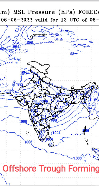
West coast offshore trough seen developing as explained in earlier blog (of June 7th. Resultant from Jet streams).
With westerlies strengthening till 600-700 hPa level along Karnataka Coast, , SWM further advanced up the west coast till South Konkan. (Actual 11th June...Estimated 12th June)
Goa: Intermittent Monsoon Showers.
However, the surge is stronger over coastal areas, so more rain will be confined to the coastal belt.
SWM line passing across Vengurla, , Belgaum, Bangalore, Chennai and into northeast India.
Seeing the Upper Winds and Jet Streams, Further progress expected into Konkan by 13th..
Northeastern states to witness further increase in rainfall starting next week.
Mumbai/Pune: Occasional Pre Monsoon Thunder Showers.
Co-author vag. Shreyas
11th June 2022
Good pre monsoon rains in and around Mumbai Metropolitan Region! Some readings ending 8:30am on 11/06/2022 in mm:
1.Andheri:66
2.Colaba IMD:62
3.Vile Parle:51
4.Bhayandar:46
5.Airport:45
6.Manpada:44
7.Malvani & Byculla:43
8.Dadar W(Vag Pvt Reading)& Kurla:42
9.Santacruz IMD:41
10.CSMT:40
11.Ramandir:39
12.Kopri:38
12.Bandra:36
13.MiraRd:33
14.Goregaon:32
15.Dahisar & Thane:31
16.BorivaliWest:30
17.Kandivali:29
18.Deonar:27
19.Chembur:26
20.Vashi:23
21.MalabarHill, Sion & Mulund:22
22.KoparKhairane:17
23.Ghansoli:16
24.Mumbra:12
25.Airoli:10
Data Credits: MCGM, IMD & IITM
Compiled by: Vagarian Abhishek Apte
Friday, June 10, 2022
10th June:
South West Monsoon Weak in Kerala...expected to remain so in Kerala till 20th June at least..
Overall India Deficiency -41%, But still Monsoon not yet covered major regionsSouth west Monsoon will advance into Coastal Karnataka , South Konkan and Goa on 12th June.
Monsoon advance in North Konkan and Mumbai by 15th June.
Mumbai /Pune will get occasional thunder showers till monsoon arrives.
No major Monsoon advance or major rainfall in Interior Maharashtra ( Madhya Mah (Pune /Nasik) /Marathwada ) and Interior Karnataka till 15th at least.
दक्षिण-पश्चिम मान्सून 12जून रोजी किनारपट्टी कर्नाटक, दक्षिण कोकण आणि गोव्यात दाखल होईल.
Thursday, June 09, 2022
9th June 2022
Premonsoon thundershowers in and around Pune and Ratnagiri region ending 8:30 am on 9th June 2022 (in mm). Core Pune city missed the spell though!
Pune Region:
1.Narayangaon:60
2.Vadgaon Rasai:57
3.Daund:54
4.Indapur:51
5.Rahu:48
6.Nimgaon Sawa:46
7.Yavat:40
8.Baramati:25
9.Talegaon Dhamdhere:10
Ratnagiri Region:
1.Kumbhavade:66
2.Devrukh:61
3.Ratnagiri:29
4.Lanja:26
5.Dabhol:24
6.Pawas:20
7.Khedshi:19
8.Soundal:18
9.Oni:13
10.Jaitapur:12
11.Rajapur:10
Data Credits: IMD & Agri Dept
Data compiled by: Vagarian Abhishek Apte
Wednesday, June 08, 2022
8th June 2022
Early morning isolated rain showers in and around Mumbai Metropolitan Region today. Some readings below(in mm):
1.Pawane MIDC:7
2.Sanpada:5.2
3.Khairna Village:3.4
4.Kopar Khairane & Vashi:1.6
Image and Data Credits: IITM
Compiled By: Vagarian Abhishek Apte
Tuesday, June 07, 2022
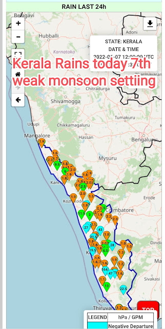
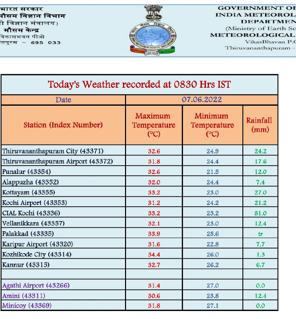
7th June... 2022
Monsoon over Kerala as a weak current. Advanced upto Kochi... As Kochi Radar showing Westerly depth
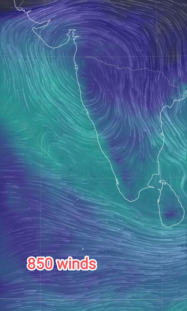
Weak Because the upper winds are stubbornly NW (not SW)
.
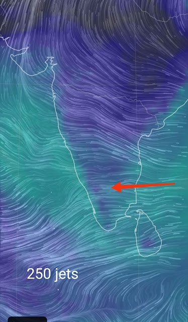
Monsoon, the seasonal change can be said to establish today as the dominating 200 jets are in place.
Today's 850 ⬇
Maharashtra Entry in South Konkan & South Madhya Maharashtra & Pune by 13th...
Proper onset of Monsoon in Mumbai by 15th.
Pre Monsoon Thunder Showers in Aurangabad & Parts of Marathwada on 9th/10th.
Monsoon in Marathwada also around 15th/16th.
मान्सून महाराष्ट्र दक्षिण कोकण आणि दक्षिण मध्य महाराष्ट्र आणि पुण्यात १३ तारखेपर्यंत दाखल होईल...

मुंबईत मान्सूनपूर्व पाऊस झालेला नाही. 8/9 तारखेपासून, शहरात थोडा पाऊस पडू शकतो, किमान दोन ते तीन दिवस हलका ते मध्यम असेल, म्हणजे 8 ते 10 जून दरम्यान.

15 तारखेपर्यंत मुंबईत मान्सूनची योग्य सुरुवात.

9/10 रोजी औरंगाबाद आणि मराठवाड्याच्या काही भागात मान्सूनपूर्व गडगडाट.

मराठवाड्यातही मान्सून १५/१६ च्या आसपास.Friday, June 03, 2022
Posted 4th June Night
Vagaries' views on SWM situation 2022:
1. Monsoon currently as a establishing current over Kerala.
2. Due to prevailing SW winds not having depth, current remains weak. But shear zone forming likely at 700 at 15N, and Westerly Winds strengthen South of it. The Zone then can move North.
3. 200 jet streams however show good signs and indications of season change in next 4 days.
4. With 200 jet streams possibly becoming Easterly by 9th june, but lower winds still not SW, we have a complex situation.
5. Resultantly, an offshore trough can form (due to core off 200 ) off the West Coast.
6.
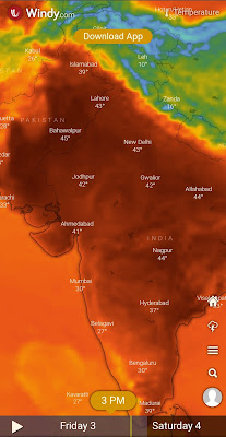
Pic courtesy Shri Hosalikar (IMD)With the heat wave picking up from 4th - 8th, seasonal low in Thar falls to 990...and at TVM remains at 1008, we will have a proper gradient to pull up Monsoon.
7. Monsoon can set over Kerala by 5th/6thJune. Progress expected along West Coast upto Goa by 9th, and into N. Konkan after the 12th (tentatively)...AS A WEAK CURRENT DUE TO REASONS MENTIONED ABOVE.
Mumbai: Pre Monsoon Showers to bring relief from 8th.Proper Monsoon not before 12th June.
Pune: Pre Monsoon showers from 7th june. Relief from heat as day temperatures can fall by 3/4°c
Marathwada & Vidharbh have not much too see except some localised shower pop ups. No sowing to be done till 15th at least.
Goa : Pre Monsoon rain showers from 6th and weak monsoon entering by 9th.
Gujarat: Hot around 40-42c in most regions. Cannot estimate Monsoon date yet. Not before 15th .
मराठवाडा आणि विदर्भ: ७ जून नंतर काही भागात मान्सून पूर्व पावसाची शक्यता आहे, मात्र पेरणी १५ जून पर्यंत तरी करू नये.
Contribution from Vag. Shreyas
Thursday, June 02, 2022
19th April Weather Statistics: Hottest Place in the World: Akola & Wardha ( Vidarbha): 45°. 10 Hottest of 🇮🇳 India: City Max & Mi...

-
Short Narration: Monday 1st/Tuesday 2nd : The heaviest rains are in Madhya Maharashtra, Marathwada, North Interior Karnataka and No...
-
Much Awaited Monsoon Analysis to Date from ..None Other than Our GSB..on "Stats and Analysis" Page..Just Recieved On Saturday ...





.png)


.png)
.png)

.png)




.png)
.png)


