Wednesday, November 30, 2011


With AS-4 weakening on Wednesday, its down to 1000 mb with 25 knts winds, the track and rain forecast put up by Vagaries (map) on 23rd November was stuck to almost "obediently".
Periodically, the map, with the original, has been updated with the changes. Below is the latest position as on Wednesday evening.

Click here for larger view.
Latest on AS-4 as on 12noon IST Wednesday:

As per the latest NRl/JTWC report, AS-4 has weakened in the last 6 hrs. Going fairly well in accordance with Vagaries' estimate, this system is now expected to fizzle out over the A.Sea in the next 36 hrs. The centre is currently at 17N and 64E, roughly 900 kms W/SW of Mumbai.Cloud bands to the NW of the centre persist, with winds at 25 knts in that region.

As it weakens, Sur and the regions around it in Oman can expect medium rains and cloudy weather North up to Muscat is possible.

As mentioned, cloudy weather for Karachi today, stuffy and hot. 

More later.


Tuesday, November 29, 2011

AS-4 has moved N/NW in the last 6 hrs, and at 10 pm Tuesday, is located at 16.2N and 66.3E. That would mean 750 kms W/NW of Goa and 900 kms South of Karachi.

The distinguishing part is the centre, though having 35 knts winds, is relatively free of major clouding. A spiral band, 360 kms to the NW of the centre, is moving towards coastal Sindh. System is still at 998 mb with cyclonic winds of 35 knts and gusting to 45 knts.

AS-4 is set to start weakening from Wednesday. The clouds spiral rushing into coastal Sindh will produce extremely stuffy weather in Karachi tonite (Tuesday). Possiblity of light rain will make it uncomfortable. For Karachi, I do not expect the rain to persist much beyond mid day on Wednesday, though cloudy weather will linger on for another 2 days.

Another system is forming in the Southern Bay at 89E. Still in the initial stage, will discuss the developments on Wednesday.

Mumbai
was the limit on Tuesday. Hot, humid and partly cloudy ! Produced the most unbearable weather conditions.

With the high hittting 36.8c, +4c above the normal, Mumbai was the hottest in Asia on Tuesday. Thankfully it is not the hottest in the Northern Hemisphere, where Tambacounda (Senegal) was at 39c.

For India, the 2nd hottest was a far 35.2c at Surat.

Hot and humid partly cloudy weather expected into Wednesday and Thursday for Mumbai, with the day hitting 35c. Night will be an unbearable 26c. Expect a few degrees drop in temperature on Friday

April normal nights are 26c for Mumbai, and the nights rise to 27c after the first week of May. The normal day for April is 33c, and 34/35c for May.

Mumbai was in the 37c - 26c range on Tuesday ! 90% humidity at Colaba on Tuesday morning and 76% in the evening ! S'Cruz was at an avg humidity of 65%.


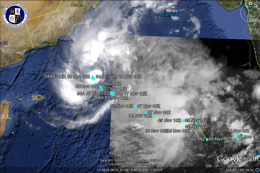
Situation as at 10 am IST Tuesday, AS-4, almost at cyclone status with winds at 35 knts. Located at 15.8N and 66.8E, mid way in the Arabian Sea between Oman and India. Moved NW.

Please notice the Sat. image showing a developing eye near the mentioned centre. Image of 10.00 am IST Tuesday. See here

Chances of Rain for Mumbai from AS-4…See Mumbai Page

Monday, November 28, 2011


AS-4 as on Monday Night:
AS-4 at 10.30 pm Monday. Located at 15N and 68E, it has moved NW. Current location is 600 kms West of Goa.Winds at 35 knts and the strength is a bit reduced at present. But that is due to the night time "cooling", and as mentioned, system will attain peak strength tomorrow afternoon, and IMD will name it "Thane" at that time.

Map updated with current location of AS-4. Forecast kept constant, no change, to compare. Click here for larger view

There are reports of some rain and thundershowers from South Konkan. Though exact amounts are not available, there is confirmed news of rain in Goa, Vengurla, Sawantwadi, Malvan, Devgad and Harnai.Rain amounts are between 5-25 mms.Vagaries had put up Monday rains 10-25 mms for the Konkan belt. Decrease from tomorrow.


AS-4 as on 2.30pm Monday: 14.4N and 68.7E...moved Due West since 11.30 am Monday.
Latest Image of AS-4 as on 2 pm Monday:

AS-4 on Monday Mid day:
AS-4, IMD has declared it as a deep depression now, is currently located at 14.3N and 69E, thus moving NW again, and steadily. It is due west of Mangalore on Monday morning.

This system has strengthened, and a deep convection is seen in the cloud mass N/NW of the centre. The thick mass is spread from 13.00N to 19.00N and 64.00E to 71.00E. In fact, the convection effect has towered the cloud tops to more than 18-20 kms in height, with the lowest minimum cloud top tempertaure touching -85c !

Well, it is expected to strengthen more, till Tuesday, when it would have reached its peak.After that, it will weaken considerably, and may not cross coast as a system at all.
Reason: The SST is 29c at the centre now, and is decreasing northwards.The ocean heat content is 80-90 KJ/cm2 as on the system's location now, but becomes less than 40 KJ/cm2 towards the North Arabian Sea.The anti cyclone on the East coast of India is pushing westwards.

Saurashtra/South Gujarat coast and North Konkan will be cloudy and have light rains on Monday.
Indications show the clouding moving towards the Sindh coast from Tuesday.

Sunday, November 27, 2011

click here for larger view
AS-4 at 12.7N and 71.0E, as on Sunday evening, has tracked NW (See Vagaries Map of AS-4 Track above). Winds are gusting at 40-45 knts, with core pressure at 996 mb. from 74.9E on Saturday night to 71E on Sunday night, hence AS-4 is moving away from the West coast.
Likely to continue tracking NW, and weakening will startt from Tuesday evening. Tomorrow it will peak at 994/996 mb with winds gusting at 50 knts.

Cloud motion vectors show spiral cloud bands will cover the west coast from Konkan to South Gujarat on Monday. Light rain possible in N.Konkan and South Gujarat. Rise in temperatures for this week for Mah. and Gujarat regions.
Clouds from the concentrated cloud mass of the system will be stretched NE towards the Kutch and (Eastern) Sindh regions by Tuesday/Wednesday.

Karachi will be cloudy (mostly medium to high clouds) on Tuesday. Light rain in some areas possible.

Mumbai will be cloudy on Monday, with light rain in some parts of the city. Tuesday will be partly cloudy with high clouds. I had mentioned that "winter" will go for a "toss" Sure enough ! Mumbai saw a low temperature of 26c on Sunday, after having 21c in the previous 2/3 nights.The High was at 36c.


Saturday, November 26, 2011

On Saturday, NEM very active in T.N. and Kerala. Heavy rains in Lakshdweep Islands.
Very heavy rainfall of 180 mms recorded in Varkala (Kerala), Pallipattu (Tiruvallur dt) and Coonoor 160 mms each, Papanasam (Tirunelvelli dt), Tiruvallur and Rameshwaram (Ramanathapuram dt) 150 mms each.
Kodaikanal receiving 128 mms had a high of 13c on Saturday, while Ooty was 15c during the day. Chennai (Mnbkm) received 84 mms ,while Ngmbkm managed 51 mms on Saturday.
Bangalore was a pleasant 23c during Saturday, with light rains in the daytime (5 mms).

(Latest and Mumbai forecast by 10 pm IST Sunday)

AS-4 at 10.7N and 72.3E, now 360 kms West of Cochin, as on Sunday Morning.Tracked NW, but slow in movement. Now, some European models are talking of the storm fizzling out at 20N !


click here for larger view


The latest on AS-4 as on Saturday, 26th night:

System has moved W/NW in the last 6 hrs from this blog report, and is now positioned at 8.7N and 74.9E. Actual position is 200 kms SW of Cochin.With core pressure at 996 mb the eastern segment of the system is showing winds at 35-40 knts (max). Strengthening is due to increase in vertical wind shear to 25 knts (positive).
There is active precipitation around the centre and to the West of the system centre. As predicted yesterday, Kerala and the Lakshdweep Islands had heavy rainfall on Saturday (today). Thiruvananthpuram and Agathi received 40 mms each. Minicoy had 34 mms.

Meanwhile in 24 hrs ended Saturday morning, Venkatgir (Nellore Dist) in South A.P. had a very heavy downpour of 230 mms, and Uthiramerur (Kanchipuram dt) received 200 mms. In T.N,hill station Kodai recieved 112 mms with the day's high at 14c on Friday.Rainfall in T.N will decrease from Sunday.

Due to favourable SST at 31c, and possible increase in wind shear, system will deepen a bit more till Monday, when surface winds would reach a max of up to 50 knts, and as mentioned, will start to weaken from Tuesday and fizzle out in a couple of days.
As system is tracking as per Vagaries' predicted path, there is no need to change or reproduce the same Vagaries map for future tracking ! -:)).

I expect some light rain on the coastal regions of South Gujarat and Konkan on Monday due to the spiralling of the clouds from the system, during its peak period (Monday). After that the clouding should decrease as AS-4 weakens (Shitij).

Mumbai forecast as put up yesterday.

For Coastal Sindh (Pakistan), other than clouding, and very light rain (traces, nothing meaningful) on Tuesday/Wednesday,I do not expect anything. Reason for clouding phenomena over Sindh has been described yesterday on this blog.

Next Update Sunday morning 10 am IST


Friday, November 25, 2011


Latest Position of AS-4 as on mid day IST of Saturday, 26th November:

Already numbered as 05A, the system is at 8.2N and 76E, about 200 kms due South of Cochin. Thus having moved N, system, now a depression, though I would put it at deep depression strength, with a core pressure at 996 mb and 35 knts winds. It is expected to storm into the Lakshdweep seas Saturday. Very heavy rains in the islands and Kerala this week end.
AS-4 is forming like a monsoon system, with deep convective mass to the North of the system and heavy precipitating heavy rains in its Northern peripherial areas.

No change in the Forecast path and rain estimate regions as per vagaries map below (maintained).Now almost all models tow the NW track line (shown initially by Vagaries), it is shown as going North by avoiding Oman , and heading for Pakistan coastline. Vagaries' estmate remains to the track shown in the map earlier (reproduced below).

However, Vagaries maintains at "fizzle out" or, at the most weaken, after Tuesday,29th. I feel AS-4 can wear out as a system, and its pressure will rise. But, the residual precipitation can remain in the region. If a W.D. is crossing the Northern regions around the same time, then, clouds from the remnants of AS-4 can spread NE into Pakistan.

Click here for larger view

Latest Position of AS-4 as on mid night IST of Friday:

7.4N and 76.5E, about 250 kms due South of Cochin. Thus having moved NW, system, now a well marked low, with a core pressure at 1001 mb and 30 knts winds. It is expected to storm into the Lakshdweep seas on Saturday. Very heavy rains in the islands and Kerala this week end.
AS-4 is forming like a monsoon system, with deep convective mass to the North of the system and heavy precipitating heavy rains in its Northern peripherial areas.

Forecast path as per vagaries map below (maintained). Next update and forecast review at 12 noon IST Saturday.


Location Position as on Friday Morning:
The UAC has descended to sea level, and is at 4N and 79E, has moved NW. Core pressure at 1004 mb and 15 knts winds.
I have seen that the Bay of Bengal has its Southern limit at 5N, hence this system has not formed in the Bay. As it will traverse majorly in the Arabian Sea, we shall number it AS-4, when it is matured.

The forecasted rain in T.N. has been widespread, with Cuddalore receiving 140 mms,Karaikal 100 mms and Nagapattinum 99 mms. Many other stations received between 40 -70 mms.
Chennai too got heavy rains,with Meenanbakam seeing 98 mms and Nungambakkam 65 mms. NE winds late last night peaked 46 kmph during a thunderstorm.Thunderstorms are active in the city on Friday morning.

Observing the current parameters, Movement expected along the track predicted by Vagaries in the Map above.

Mumbai:

Friday,25th: Partly cloudy with high clouds. Temperature range: 32c - 22c

Saturday,26th: Partly cloudy: 32c - 24c

Sunday,27th: Cloudy and windy: 31c - 25c

Monday,28th: Cloudy. Light rain in some parts of the city. 30c - 25c.

Observe, that the " wintry" trend in Mumbai, however mild, will take a back seat now for a few days !


Overcast Friday in Dubai..see Pics on Inter active Page

Wednesday, November 23, 2011

Location Position as on Thursday, 24th, Evening:
The UAC has descended to sea level, and is at 3N and 82E, South of Sri Lanka. Core pressure at 1004 mb and 15 knts winds. Readers, please check location on map, and suggest if we should number this as BB (from Bay) or AS (from Arabian Sea) ??
Anyway,do not under estimate its strength. Its maximum effect is in Sri Lanka. Chief amounts of rainfall in Sri Lanka today: Auradhapura 64 mms, Tricomalee 60 mms, Mannar 55 mms, Jaffna 43 mms.
Observing the current parameters, Movement and precipitation expected along the track predicted by the Vagaries Map put up yesterday.

x-----------------------------------x------------------------------x---------------------x-----x

Posted on Wednesday, 23rd, Evening:

Keeping Sunday's weekly forecast in mind, and following it up:

We see the Southern UAC has formed, numbered 98B, by NRL. But, instead of forming off the T.N. coast as expected, it has formed much lower. After moving due west in the last 12 hrs, the UAC is stationed at 3N and 82E, S/SW of Sri Lanka. Now, Vagaries had expected the system to form much to the North, and cross the T.N. coast as a sea level low by Thursday, but being South, it will cross Sri Lanka and move West into the Arabian Sea.

Should descend to sea level as a low in the next 2 days.

Though less than expected, T.N. will receive heavy rains from Thursday and rains spreading inland.Inland, districts in the East, SE and the Northern regions of the state will receive good precipitation Friday/Saturday.

Chennai will get precipitation amounting to 5-7 cms on Friday, increasing to 7-9 cms on Saturday, with squally winds from the NE.

Click on Map for larger View

By Friday, the low (should be around 1002 mb then) will just enter the Arabian Sea regions. And Saturday will see the low track N/NW and run parallel to the west coast.

See the Vagaries Forecast Map put up.Rainfall colours are as per the key.


Its my personal view that the system will deepen to 1000 mb and move NW to fizzle out as shown.

A fresh W.D. is moving across the North regions, and will precipitate in the hills. Cloudy weather for Punjab, Haryana and Delhi next 2 days.

Mumbai "sobered" down on Wednesday, 23rd. We had expected some relief after Tuesday. S'Cruz was 34c and Colaba's high was 33c.

Tonite (Wednesday night) we may see S'Cruz dropping to 18c.

Pune too kept the schedule, and was better today at 29c as the high and 11c as the minimum.


Tuesday, November 22, 2011


Cold Nights in Southern States of Karnataka and A.P.

Cold Wave in Interior Karnataka: Lack of clouds causing loss of the day's heat has resulted in a cold wave in interior Karnataka. The lowest night temperature in the state on Tuesday morning was 9c at Hassan, which was 7c below the normal for this time.
Amonst the other lows were: Chamarajanagar at 11c, Dharwad at 12c, Bijapur and Haveri at 13c and even on the coast, Karwar was 18c, 3 below.
Bangalore was a pleasant 16c and 15c at the airport.

Adjoining regions of A.P. are also experiancing low and below normal temperatures.
Adilabad was lowest at 11c in the state, and Hyderabad saw 14c on Tuesday morning. Cuddapah dropped to 16c, which may not seem low, but was 5c below normal for the place !

Sunday, November 20, 2011

A Must Share with Vagaries Readers...Unusual and intriguing Cloud Formation viz. "Cloud Streets"…see Space News Page

Mumbai November Heat..see Mumbai Page

Publishing Next week's expected Developing situation and Weather forecast for the South. Its a 7 day estimate, and will be monitiored as it happens.

As mentioned yesterday, a UAC is likely to form off the South T.N. coast/Sri Lanka around Tuesday, 22nd November. This is likely to descend to form a sea level low in the same region within next 2 days, say around the 24th (Thursday). The said Low is expected to deepen (by then it would be numbered) and cross the Southern coast of T.N.

Squally NE winds are expected along the T.N. coast and Chennai from Thursday.

Hence, the coastal regions of T.N. and Chennai can expect increasing rainfall from Wednesday/Thursday, with heavy falls by Friday. Chennai can expect upto 7 cms on Friday, 25th. Interior T.N. can get meaningfull rains after Thursday thru Sunday.

As the system crosses the coast, the precipitation is expected to spread into North T.N. and S.interior Karnataka around Friday.

Vagaries shall keep track of this, as it is still 5/6 days away.

Vagaries expects this system to cross into the Arabian Sea in the subsequent week , and emerge as a low off the Kerala coast around Tuesday 29th.
Very difficult to foresee the movement and track at this stage (10 days in advance), but current conditonal observations and expected track study indicates a North movement, but a very slim survival chance of more than a couple of days for the system.

North India:
Due to the moving away of the W.D, ground fog occuredin the Punjab, Haryana, Delhi and West U.P. regions on Sunday morning. Visibility was low and up to 50 mtrs. Clear skies and enough moisture will create the perfect conditions for ground fog in the same areas on Sunday night/Monday morning.

Delhi's day temperatures will be around 27c on Monday, with fog reducing visibility to 0.2 kms in the morning hours, while the night is expected to drop to 12c.
Chandigarh will be in the 25c - 12c range.

With no W.D. approaching, Pakistan should be dry. A fall in the night temperatures could be expected in the Sindh regions from Monday night.
Karachi heated up to 35c on Monday, in line with the adjoining coastal regions of India. East dominating winds were prevailing for most of the day, preventing the SW sea breeze from setting in. With the current minimum at 18c, it is expected that a marginal cooling trend will be seen from Monday night. Should expect a low of 17/18c by Tuesday/Wednesday.

Mumbai:

With the winds veering more to the East as expected on Sunday, Mumbai Colaba hit the predicted high of 36c, while S'Cruz was almost same at 35.8c.

Mumbai retains the 2nd place in Asia on Sunday, while Laem Chabang (Thailand ) was highest at 37c.

Expecting the trend continuing on Monday, with the high at 35/36c. Nights will get cooler from Monday/Tuesday. Monday and Tuesday minimum will be about 18/19c at S'Cruz and 22/23c at Colaba.

Cloudy conditions possibly returning on Friday (due to situation explained above).

Pune will be warm in the day on Monday and Tuesday. Day's high will be 31c and low a comfortable 10/11c. Cloudy weather and rise in night temperatures from Friday.

Saturday, November 19, 2011

See Inter-Active Page for pic of Delhi Today..

Mumbai Colaba scraps thru as the 2nd hottest place in Asia on Saturday (19th) with the day at a sizzling 36.0c. A hot weekend for Mumbai estimated for Mumbai (Vagaries' had put up 36/37c ) is taking shape (sorry Junaid), and as expected, the Mumbai temperatures for week end till Monday will be 36/37c.
A bit of relief was the 18c at night in S'Cruz and not so comfortable 23c as the minimum in Colaba.

The temperature at S'Cruz was 35.3c. It was hot, and were several 35s along the West coast on Friday.Ratnagiri was 35.9c and Surat 35.0c.

However the highest in Asia on Saturday,19th was Karwar (India) and Pattaya (Thailand) at 37c.
The NE winds along the west coast is turning towards the east now. (See earlier blog for this). Expect 36/37 along the North Konkan coast on Sunday/Monday.

BB-10, the low has fizzled out. A UAC is likely to form off the South T.N./Sri lanka coast around the 22nd. Meaningful rains likely in Sri Lanka and South T.N. from 22nd. Shall keep posting developments on Vagaries.

Friday, November 18, 2011

Hottest in Asia On Friday, 18th: Makkah (Arabia), Nawabshah (Pakistan) and Pattaya (Thailand) at 36c.

Mumbai comes a close 2nd at 35c. But not alone, a host of other cities in Asia were at 35c. They are Rajkot, Bhuj, Surat and Veraval (Gujarat), Kota, Akola, Mangalore and Ratnagiri in India, Bangkok, Yangon and Sindh Hyderabad.

And the Contrast…

UAF SMITH LAKE........................49 BELOW (UNOFFICIAL)

NORTH POLE KJNP.......................46 BELOW (NEW RECORD)
CHALKYITSIK RAWS......................47 BELOW (UNOFFICIAL)

BEAVER RAWS...........................46 BELOW (UNOFFICIAL)

TELIDA RAWS...........................45 BELOW (UNOFFICIAL)

ARCTIC VILLAGE........................44 BELOW

FORT YUKON............................44 BELOW

MANLEY HOT SPRINGS....................44 BELOW

NIKOLAI...............................44 BELOW

COLDFOOT..............................42 BELOW (UNOFFICIAL)

LIVENGOOD RAWS........................42 BELOW (UNOFFICIAL)

TANANA................................39 BELOW

NENANA................................38 BELOW

Taken from Mark’s Blog..more details there.


Thursday, November 17, 2011

Mumbai, at it again, by sharing the first place on Thursday !

For Asia today, Thursday, 17th, Nawabshah (Pakistan), Mumbai, S'Cruz and Colaba, Prachin Buri (Thailand) share honours for the hottest place at 36c.

Makkah (Arabia), Honavar and Ratnagiri (west coast, India) and Veraval (Coastal Gujarat) come a close second at 35c.


N-3, a fresh W.D, predicted 4 days ago by vagaries and put up in the monthly forecast, is expected to precipitate rain/snow over Northern Pakistan on Friday, and move eastwards into Kashmir and H.P. from Saturday.

It is hoped, that the effect of this W.D. will dislodge the anti cyclone over N/Central India, and change the winds from East (East winds are exepcted on Sunday) to NW. This pattern re-organisation should bring down the day temepratures in the Western India coastal regions from Tuesday (possibly a day earlier).

Due to weak momentum and insufficient surface energy, BB-10 has failed to develop, and is stationed as a low at 1010 mb, off the T.N. coast. It has spread its clouding on to the T.N. coast. After all it is a system, though weak, and is expected to precipitate rain along the T.N. coast and interiors of the state during the week end.
In fact, by Saturday, as the low dissipates on the shores, we can expect some heavy rains in some pockets along the coast. Chennai too can get some heavy showers by Sunday.

New Evidence for Liquid Water on Europa…See Space News Page for more on this exciting breakthrough.

From Mark’s Blog:

Spate of Tornadoes roar across Southern states, causes damage, Alaska shiversTornadoes were reported in Louisiana, Mississippi and Alabama..See temperatures Map of Alsaka on International Page.


Wednesday, November 16, 2011

An anti-cyclone over Central India, swirling winds clockwise, has resulted in hot, dry winds blowing NE onto the Saurashtra and S.Gujarat/N.Konkan regions in the last 4/5 days. 

Hottest in Asia on Wednesday, 16th November:
Alibag (Maharashtra,India) : 36.4c. 
Mumbai Colaba, second with a close 35.8c.

Late setting in of sea breeze over Mumai has shot the day temperatures to an "all Asia" record for the city a couple of days ago.

Could get hotter at the weekend for Mumbai, as the anti cyclone shifts, and the winds are likely to become "a warm easterly".  Temperature in Mumbai could touch 36/37c on Sunday/Monday. Nights will show a drop upto 21c.


Tuesday, November 15, 2011

Click on map image:

The Monday IMD anomoly maps show great above normal tendency in both Max. and Min. temperatures throughout India.

Hottest in Asia on Tuesday, 15th November: Veraval (Gujarat, India) : 37.1c. In Pakistan Mithi was highest at 35.5c.

Divergence of winds to NE and high pressure ridge firm on Central India causing higher day temperatures below the 25N line.

BB-10 stationary at 12.4N and 89E, still weakish with no firm cloud bands. Needs a 'energy push" to strenghten the system.

Mark' Blog:

While Greeks shiver, UK may be on track for Warmest November on record, hot on heels of record warm October! North Wales was 8C above normal while Athens was 10C below normal on Sunday

Monday, November 14, 2011

Mumbai:

Dry winds from the E till the late afternoon, delayed the NW sea breeze from setting in early. This pattern is persisting since last 3 days.

Hence warm inland winds till 3 pm shot up the day temperature in Mumbai. Unusual winds blowing from land to sea all along the Northern region of the West coast/Konkan coast kept the humidity low, and the temperature high.

Resultantly, Mumbai S'Cruz at 36.3c, managed to become the hottest city in Asia on Monday. The highest in Asia on 14th November ! The mercury shot up to 36.3c at S'Cruz, 35.2c at Colaba. The other hot places along the coast were Veraval (Gujarat) 36.0c, Surat was 35.6c on Monday.

Some clouding (alto cumulus/strato-cumulus) could be expected in Mumbai on Tuesday, as a result of the excessive above normal temperatures.Day will be at 34c, slightly lesser temperature, but a bit more humid.

BB-10 weakened a bit to 1010 mb with 15 knts wind. It has moved due west and has passed the Andaman islands and is at 12.4N AND 89E.

An effective W.D, N-3, is expected to reach Pakistan’s Northern regions by 17th/18th November.

Sunday, November 13, 2011

Sunday Night Headlines:

-Surat Hottest in Asia on Sunday! 36.6c.

-Mumbai S'Cruz very close 2nd at 36.4c.

-BB-10 at 1008mb moves N.

From Mark’s Blog:

2 feet of snow and 100 mph winds roar across Colorado and America West.

Underwater Volcanic Eruption off Canary Islands...Volcanic Eruption Could Give Birth to New Island….see video attached.


Saturday, November 12, 2011

1. BB-10 ! Vagaries' estimated 3rd and final (for November) system from the Bay is born.
Yesterday we discussed of a low brewing in the Andaman Sea. A "low level circulation" has formed around the Islands, and is given the status of 97B by NRL. It is just around 1008 mb today (Saturday) evening. BB-10 will build up slowly and travel westwards for now.

2. The low off the SW of Sri Lanka has dissipated. Nothing can be expected of it now. Rainfall will be subdued in the Southern Peninsula states next few days. Weak phase continues for the NEM.

3. Kathmandu had cloudy weather on Saturday with traces of rainfall. There will be light rainfall on Sunday also, with the day's high estimated at around 22c and a low of 13c.

4. With no W.D. in sight, dry and cold weather is expected in Northern and NW India. NW winds have started cooling the NW region, and expect nights to get cooler in Punjab, Haryana, Delhi and West U.P.
Expected lows in next 2 nights,
Chandigarh: 12/13c, Amritsar: 10/11c and Delhi 12/13c.

Dry weather expected in Pakistan. Cool NW winds will bring down the temperatures in the plains and Upper Sindh regions.

5. Mumbai position : Forecast v/s actual in bracket.

Saturday: 34c - 20c : (35-20)

Sunday: 32/33c - 19c N/W winds in the evening.

Monday: 32c - 19c.

6. Pune was at a low of 14c on Saturday (estimate 13c). Though the day was high at 33c, I expect another cool night and Sunday morning should see 12/13c.

Hottest in India on Saturday was Akola (Maharashtra) at 36.1c. Surat (Gujarat) was a fraction behind at 36.0c.

Hottest in Asia on Saturday was Makkah at 37c.


Friday, November 11, 2011

The low SW of Sri Lanka persists in the same position as given in previous blog. Though not approached the Island yet, should precipitate rain by this week end over Sri Lanka.

The much awaited and anticipitated low mentioned in Vagaries' November forecast ( for the 8th) may eventually form it seems. Conditions for the formation of a low are brewing around the Andaman Islands, and in fact Thai map shows a low of 1008 mb there as on Friday evening. For numbering it, Will wait and see the progress.
If it matures, then, as mentioned in monthly forecast, should track towards the T.N coast as a depression at least.

The passing of N-2 will eventually cause cooling in the states of Punjab, Haryana and Delhi from Saturday thru Tuesday.
The central plains, i.e. M.P. and Gujarat will see a fall of 2/3c in the night temperatures.

Moisture from N-2 can possibly bring some light rain in the weekend in central Nepal.

We had forecasted cooler nights for Pune from Friday (13c estimated on Monday, 7th Nov). and so be it ! Pune was 13.4c on Friday morning. Saturday and Sunday will see the day around 31c and a cooler night at 12/13c.

Mumbai, warmed up more than expected in the day these last few days. However, the minimum temperatures were almost along expected lines.

The forecast put up on Monday (7th) last, and the actual temperature in brackets shown here for performance study.

Mumbai S'Cruz Temperature Forecast v/s Actual:

Tuesday: 34 - 22 : (34-24)

Wednesday: 33 - 22 : (36-22)

Thursday: 33 - 21 : (37-21)

Friday/Saturday: 32 - 19/20 : (35-21) ( However, Colaba was 32c).

Forecast for this weekend for Mumbai Santa Cruz:Clear Sky.

Saturday: 34c - 20c

Sunday: 32/33c - 19c N/W winds in the evening.

Monday: 32c - 19c.


Thursday, November 10, 2011

Vagaries of The Weather © was started initially to share views and facts on the weather. It was created with passion and I was always keen to keep weather enthusiasts abreast with the latest, and share my experiences with them.

Used my limited knowledge by posting the latest on the SWM progress thru the "Monsoon Watch" series, and chased depressions and systems trying to figure out their erractic behaviour. Caught myself running up the wrong "track" at times.

By trying to place the jig-saw pieces in place, I try to work out the regional forecast..and many a times find myself sailing "upstream". As one ardent reader gave a comment sometime ago.."Rajesh, you are sticking your neck out again ".

Whether its the hottest day, or the coldest night, or the wettest place..any news weather wise... is attempted to be shared on Vagaries.

Initially my scope was limited to the Indian weather scene, but, recently, I have taken the liberty to extend and cover the neighbouring countries and some parts of the Middle East region. Always am keen to learn more about the weather in the sub-continent.

Hope readers in the neighbouring countries enjoy this blog and find it useful, and send feedback and their views.

Vagaries has a numbering method for W.Ds and other systems from the seas.This has made blog reading much easier and less complicated when 2 or 3 systems appera simultaniously. W.D. numbering was started 2 seasons ago, and are named month wise, that N-2 for the second W.D. in November.

Vagaries commenced covering European and U.S. weather events by partnering with Mark thru his blog.

With many regular readers of Vagaries interacting and with their inputs, our blog has become more responsive.

Ok, someone wants to remain anonymous, its their decision.

Its appreciated that by adding a little humour, readers do not want to demean the seriousness of Vagaries. I have maitained vagaries in all earnestness, and am thankful to have sincere readers who consider reading this blog as part of their daily routine.

An occasional bout of light reading and humour is always welcome. Laughter is the best medicine, as "you dont stop laughing because you grow old, you grow old because you stop laughing" !

Getting the blog more technical is not going to help many a reader. In fact, if one goes thru the previous comments, Vagaries had received requests to make it simpler to understand. As our regular reader Pavan says, readers come from a variety of fields, and want the blog simple and comprehensive.


As-3 Northward Bound ! Weakening, but still at 1000 mb.


Wednesday, November 09, 2011

AS-3 is almost stationary at 15.8N and 58.5E since the last 6 hrs, having moved very marinally a bit Northwards. As expected, it has weakened a bit to 1000 mb with winds at 30 knts. Vagaries expects further weakening as the system moves N/NW.

N-2 gets active in the North India:

Higher reaches of the Kashmir Valley, including those surrounding the Gulmarg resort (4.6 mms), received snowfall while parts of the region recorded light to moderate rains on Wednesday. Kashmir's Kupwara town recording the maximum 19.2 mm rainfall.
The Srinagar-Leh national highway, connecting the frontier Ladakh region with the rest of the state, was today closed for traffic following heavy snowfall at Zojilla Pass and Gumri.

The minimum temperature in Gulmarg on Wednesday was -2.3c, while Pahalgam received 1.6 mms with the minimum at 2.6c.
Srinagar had light rain today with the day's high at 12.5c and the low at 5.2c.
Srinagar received 1.1 mm rainfall and the tourist resort of Pahalgam received 1.6 mm rainfall.

As mentioned, N-2 effect was also felt in Pakistan, with some rain in Balochistan and Northern regions. Quetta got 6 mms, hill station Muree had 9 mms , Islamabad 6 mms overnight and traces of rain today in the day, with the temperature in the range of 24-13c.
Karachi was cloudy and hazy today, with the hight at 31c.Skies will start clearing by tomorrow evening(Thursday).The AS-3 clouding could bring light rainfall in the interiors of lower Sindh regions on Thursday.

N-2 was expected in Pakistan till Wednesday, and has moved away eastwards.

Nepal is enjoying fair and dry weather with winter temperatures taking a slow grip. Kathmandu was 27c today (Wednesday), with the night at a chilly 8.7c. Dadeldhura was in the 21-9c range today.
N-2 effect will be felt with light precipitation around Kathmandu during the weekend.

Seeing a relatively dry period for the next 4/5 days for T.N./Karnataka/Kerala regions. Unfortunately, the expected low (Vagaries November forecast) did not form. Do not see any meaningfull rains in the South next 4/5 days.

However, a low is forming just SW of Sri Lanka at 5N. May not deepen much, but will bring precipitation to Sri Lanka and extreme Southern India tip by the weekend.

Could this become the system estimated to emerge in the Arabian Sea?(Mentioned in Vagaries' November forecast for a system to form around 12th).

ALASKA WEST COAST TO BE HIT BY ONE OF THE MOST SEVERE BERING SEA STORMS ON RECORD... A 943mb storm roars into Alaska tearing off roofs, sends rushing water through coastal communities

It’s a record breaking weather event…for detailed report see Mark’s Blog.

Tuesday, November 08, 2011

Update 7.00am IST Thursday.
Tropical Cyclone 04A --AS-3---continues its Northward track. Earlier, Vagaries had mentioned it could curve Northwards after crossing the 13N latitude. Expected to track N/NW .
Position as on 5.30 am IST Wednesday shown below on JTWC track chart. Details of system mentioned in the chart..click here


x-----------------------------------x-----------------------------------x-------------------------x-----------------------x----------------------------x----------------------------------x----

Click here for larger image.

Storm Near Oman. Surge Maintained.

AS-3 moves N/NW and positioned at 14.4N and 58.4E on Tuesday night. Note, it has now taken a more Northerly track (see Sat. Image above) as estimated by Vagaries. Core pressure at 996 mb is constant and winds at 30 knts. A slight curvature of cloud formation is now also seen in the South of the system.


Southern Oman coast, and city of Salalah can expect squally weather with intermittent rains from tonite and on Wednesday. Muscat will be cloudy with light rains on Wednesday. I expect the system to move N/NW and weaken. Hence rainfall and stormy conditions will decrease in coastal Oman from Thursday.

Remnants clouding of AS-3 is now being pulled towards the east by the upper winds. Precipitation along this NE course in the Sea between the Oman and Pakistan coasts could be expected, and some rains along the Western region of Sindh coast from Thursday. As mentioned yesterday, Karachi was cloudy on Tuesday, and will continue to have cloudy weather on Wednesday, with light drizzle on Thursday.

click here for larger view
Sudden Surge in As-3

After a brief weakening yesterday, AS-3 has shown a sudden intensification overnight on Tuesday morning. At 6.00 am ISt on Tuesday, the system is at 996 mb (previously 1005 mb) and with winds sharply rising to 30-40 knts. Designated number 04A given by NRL and otehr models.

It has tracked NW and is at 13.7N and 59.4E currently.

Rains expected on South Oman coast and Salalah today as the storm nears.Heavy rains in southern coastline of Oman.Muscat will also get increasing showers from Tuesday thru Thursday.
System could weaken rapidly within 48 hrs as it moves N/NW.

Upper winds spread the clouding towards the Kutch and Sindh coast.

Monday, November 07, 2011


AS-3 on 7th November, at 13.2N and 60.4E. ( 8.00 pm IST Monday). Indicating a NW track heading towards Oman and gradually away from the Indian coasts.
However the system seems to have weakened as pressure now measured is 1005 mb, and winds are at 20 knts.
In a change of scene, due to "provocative" factors, the convection is now seen in the North of the system. As-3 will move NW and then curve Northwards for a short distance and weaken, before fizzling out off the North Oman coastline ( by Thursday at the most).

Winds at 200 mb could push upper clouds at that level towards the East over Sindh coast from Tuesday.Karachi would be cloudy on Tue/Wed.

Southern shores of Oman, and Salalah will start getting some rains from Wednesday. The rainfall may not be damaging, and will move up the coast on Wednesday/Thursday.

An effective W.D, N-1, is moving towards the sub-continent. Will be over the Northern regions of Pakistan by Monday night/Tuesday. Rainfall could be expected in the Northern plains of Pakistan and Balochistan areas on Tuesday and Wednesday. Snow in the Northern mountains is also not ruled out.
Islamabad will get light rain on Tuesday and Wednesday, with the temperature range between 26-11c.
Cloudy effect on upper Sindh areas.

N-1 would be moving into India from Tuesday night/Wednesday. Precipitation is expected in Kashmir and H.P, with snow on the hills. Punjab and Haryana will get cloudy weather with light rains. Chandigarh will be cloudy on Tuesday and light rain is possible on Wednesday. Day will be around 27c.
Delhi will be cloudy on Wednesday with temperatures around 29c in the day. Fall in night temperatures after Thursday all over plains of North and NW India.

Pictures of N-1 clouding and rainy effect in Dubai on Monday sent by a reader (Priya) put up on Interactive Page. Rain to continue in Dubai on Tuesday.

Mumbai: Partly Cloudy/Hazy skies for Tuesday/Wednesday.

S'Cruz Temperature Forecast:

Tuesday: 34 - 22

Wednesday: 33 - 22

Thursday: 33 - 21

Friday/Saturday: 32 - 19/20.

Pune will be in the 31 - 16c range till Thursday. Friday I expect the nights to drop to 13c and Saturday to 12/13c.


AS-3 on 7th November, at 11.7N and 63.3E. ( 6.00am IST Monday).

click here for larger view

Winds at 200 mb could push upper clouds at that level towards the North-East over Kutch and Sindh coast from Tuesday.

Sunday, November 06, 2011


IMD has declared the system AS-3 as a depression today. It is currently located at 10N and 65E, having been almost stationary (slight SW erratic track) last 6 hrs. Core pressure however steady at 1004 mb and same wind speed at 20-25 knts. Seems to be heading for Oman, as seems difficult it will cross the 12/13N latitude.
Northward movement towards Sindh possible if it crosses the 12/13N latitude

IMD also stated that -Quote" This system would not affect Indian coast." Well, our met. guys are forgetting the Lakshdweep Islands. There was heavy rain today as a result of the system with Amini Divi receiving 100 mms in 24 hrs on Sunday and Minicoy 56 mms in the same period.

Also as mentioned in Vagaries, Kerala and Karnataka coast received some rainfall on Sunday. In Kerala, Vadakara: 205 mms, Chittur: 92 mms, Mannarkad: 80 mms, Kupaddy: 60 mms, Alathur: 59 mms and Thiruvananthpuram got 17 mms, Kozhikode got 15 mms.

Naturally, lesser amounts in coastal Karnataka with Mangalore managing 11mms. S.I. Karnataka too has some rain with Agumbe getting 37 mms, and Bangalore getting 19 mms.

What now ? well AS-3 seems determined to take a West path. So, decreasing rainfall in Lakshdweep and coastal Karnataka ( the sun peeped out amidst clearing clouds in Mincoy by 5.30 pm ISt Sunday. Amini Divi though was overcast all day Sunday, with a thunderstorm at 2.30 pm on Sunday) .

Easterly currents will keep the precipitation on in Kerala (though reduced).

Oklahoma shakes by strongest earthquake ever recorded in state on Saturday night.

Bone-chilling cold brings harsh return of winter to European RussiaSee International Page. Details from Our Partner Mark’s Blog.


Sunday Blog:
After a NW movement as per last posting, AS-3 has moved due West in the last 6 hrs...from previous location of 10.8N / 67.5E to currently (12 noon IST Sunday) 10.7N / 65 E.....due West.

It seems this change of track from the expected NW track is due to the upper air 200 mb jet streams. These jet stream upper winds have markedly become due West below 15N (not very normal for Nov.) in the last 12 hrs. Even the 500 mb winds are supportive to the upper winds, and are flowing West below the 15N line. Surely influencing the movement of the system. AS-3 Pressure is at 1004 mb with 20-25 knts winds.
System could re-curve the track to NW if it is able to cross the 12/13N line. Otherwise, would maintain a Westerly track.

Resultantly seeing good cooling in the Central India region (M.P./Mah/Gujarat/N.I.Karnataka), and NW plains from early next week.
More on this in a later blog.


Saturday, November 05, 2011


Latest on AS-3:


The well marked low is currently ( 9.30 pm IST Saturday) at 10.8N and 67.5E, that is having moved NW in the last 6 hrs. Core pressure remains at 1006 mb, and winds are at 20-25 knts /hr. As mentioned, and seen in the sattellite image put up, the system shows convective clouds in the Western quadrant. Also seen is a weak developing spiral forming.

Expected track is N/NW, and precipitation can occur along the Kerala/Karnataka/Goa coastline. As the system tracks, we could see cloudy weather to some rain in S.Konkan from Monday.

In the North, weather will be dry. Day and night temperatures are expected to drop by a couple of degrees in North and NW India from Sunday. Delhi should see a minimum of 14/15c next 2 days, and Chandigarh and Amritsar will touch 11c with the day going below the 30c mark.


See International Page for latest U.S. West Coast Storm…


x-----------------------------------------x---------------------------------x------------x
AS-3 has tracked West in the last 12 hrs. Positioned currently (12.30 pm IST Saturday) at 9.7N and 68.7E, it has a core pressure of 1006 mb. Convective cloudings are seen in the West of the centre. Very mild and dis-organised spiral forming.
Track expected N/NW.


Forecasted East rough  Let's look into the 3rd week of March ( 17th - 21st). Mumbai : Hot weather likely for Mumbai region this week, ty...