
December almost over...But City still Warm.
Mumbai is facing a winter , a "warm winter'' untypical of a normal December for the city.
It has been a hot start to Mumbai's winter, with the temperatures above normal throughout the period, especially in December, averaging around 3c above normal.
Since 3rd December this year, Mumbai has seen day temperatures above 33c ( 2/3 c above normal) on all days )as of 29th December). The top being 35.7c ( +4c)on 24th.

Thus the daily day/night average for December works out to 27c..2c above normal.
But, as people's memory is short, let Vagaries remind all that, Mumbai had a much warmer December in in 1987 when Day was 39.8c on 4th December, the Monthly warmth was 4c above the normal. In 1990, the temperature averaged 6c above normal !
Normally for Mumbai, the winter starts with the cold winds blowing from the North, generating from a Western Disturbance system in the Northern plains and Himalayas. . But this year an "anti Cyclone" system in Central India blocked the cold winds, and brought Easterlies and South Easterly winds, which are dry and warm.
A Western Disturbance System can approach Northern India around 6th January 2024. Mumbai can then get some pleasant weather after 7th, and cooler temperatures around 16/17c. Outer townships of Mumbai can go down to 15c.
29th December
Cyclonic circulation seen over southern Arabian Sea...two regions of convection and vorticity.

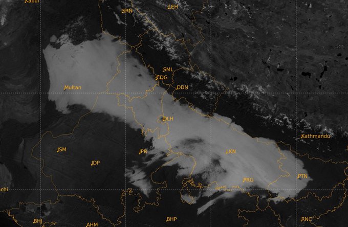
At 12 pm 29th December, widespread fog seen covering a larger stretch over IGP region from Pakistan to Bihar.
Foggy day for the entire region. The entire is dry with temperature inversion seen near the surface and a highly stable atmosphere in terms of -e profile. 700 mb circulation shown.
More on the Extreme Rainfall in Kayalpattinam...Some Explanations...
On Sunday (December 17), the Kayalpattinam locality within Tamil Nadu’s Thoothukudi district received a whopping 96 cm worth of rainfall in a single day, much higher than what the district receives in an entire year (up to 70 cm)! This intense soaking is down to several factors.
Typically, heavy rainfall of this magnitude is linked to well-defined systems like cyclones. However, in this instance, it was a mere upper-air cyclonic circulation over the Comorin area that triggered such substantial precipitation.
“There was more moisture inside the system which gave widespread rainfall, but usually upper air circulation doesn’t give this much rain. This (system) has given more rain than a cyclone,” S Balachandran, head of the Chennai-based Regional Meteorological Centre (RMC
This rainfall is both unusual and unprecedented especially when we are in the fag end of the northeast monsoon. Nothing like this has happened in more than 100 years,” said YEA Raj, the former deputy director general of the Indian Meteorological Department (IMD).
The torrential showers in Tamil Nadu's plains on Sunday and Monday constituted one of the highest-ever recorded rainfall episodes within a 24-hour period for the region. While such intense rainfall is more common in hilly regions, it is exceedingly rare in plain areas.
In spite of the unusual downpour, however, it is essential to acknowledge that additional factors may have contributed to this event. For instance, the slow movement of the rain-bearing system over the Comorin area—akin to Cyclone Michaung's stalling near Chennai on December 4—likely allowed repeated convergence at the same location.
Meanwhile, owing to the absence of an IMD observatory in Thoothukudi, the state government's observatory has provided this rainfall data to the National Data Centre in Pune. This data will undergo verification against previous years' records to gain further clarity on the significance of this single-day rainfall event and the records it may have broken.
Excerpt From "The Weather Channel,"
18th December...NEM fury
Kayalpattinam in Thoothukudi records 932 mm in 24 hrs. (This is more than their annual rainfall falling in a day).
This is the highest ever rainfall recorded in plains ever in Tamil Nadu in 24 hrs & the 2nd highest rainfall after the Kakkachi (manjolai) 965 mm recorded in 1992.

Information from Pradeep John.
18th December...Vigorous NEM
Kayalpattinam in south Tamil Nadu records extremely exceptional heavy rains of 950 mm in the past 24 hrs.

A slow moving cyclonic circulation in Comorin sea and the associated large scale moisture transport from the east and south favored such extreme rains in much of south TN.

Mumbai/Pune to move around the "Normal" temperatures 11th Dec to 15th Dec (Next Week).
Mumbai:
* With the rains finally leaving Mumbai, and the humidity decreasing, City may get relief from the sweaty coastal weather. Currently at 65%, humid conditions may improve to 55%
* Coming week, Mumbai will see the nights getting cooler., with a "slight Nip". The best witnessed this season was 19.7c on 30th November. May get to around the "Normal" yellow line (around 18/19c).

* Days, already hovering around normal, will set at 31/32c.
*Panvel/Navi Mumbai/Karjat may get lower to17/19c.
Pune:
* On 16th, Pune saw the lowest this season, 14.4c.
*Coming week may hover around 12/14c, moving around the normal yellow Line.

Sambhajinagar:
* Lowest has been 13.2c this season on 17th November. Now, with the cloudy conditions , the temperatures were around 16c.
* But with no rains and clear skies, the city may see nights at 12/14c again. May benefit standing "Channa" and Wheat.
------------------------------------------------------------------------------------------------------------------------------------------------------------------------------------------------------------------------------------------------------

6th December
Cyclone Michaung nears the end of it's life cycle in Telangana.
It will go into records for causing extremely very heavy rainfall in Tamil Nadu and Andhra Pradesh.
500 mm rainfall fell within 36 hours across several parts of Chennai and its suburbs.
Mini Tornadoes were formed in AP.
(Vag.Gokul)
In such emergencies, Nowcasts need to be accurate.

Based on JTWC data, with a wind speed of 60 knots, Cyclone Michaung is the strongest December cyclone in the north Indian Ocean (including both the Arabian Sea and the Bay of Bengal) after 2016.
Note: Cyclone month distribution is defined based on the first day the cyclone attained cyclonic storm strength (wind speed 35 knots).
For the period 1982-2023, the maximum wind speed of cyclones in the north Indian Ocean in December is increasing at the rate of 2.8 knots/decade.
Attached is the maximum wind speed of the cyclones in December in north Indian Ocean for the period 1982-2023. Data: JTWC


Very Heavy rains and water-logging reported across Chennai as western sector of Severe Cyclone Michaung batters north Tamil Nadu and south Andhra Pradesh coasts!
Chennai city 229.2 mm till 8:30 pm
Chennai Airport 180.2 mm till 8:30 pm
Rainfall will decrease significantly from tomorrow.

Cyclone Michaung currently maintaining an intensity of 35 knots as per IMD.
Currently, low wind shear and robust poleward outflow supported by high SSTs and moderate ocean heat content will favor the cyclone to steadily intensify till the evening/night of 4 December. It is likely to reach a peak intensity of 90-100kmph by the night of 4 December. As of now, rapid intensification chances are low.
This is the 4th cyclone of the post-monsoon season in the north Indian Ocean. This is the highest number of cyclones in the north Indian Ocean post-monsoon season after 2019.


3rd December......
Cyclone Michaung...!
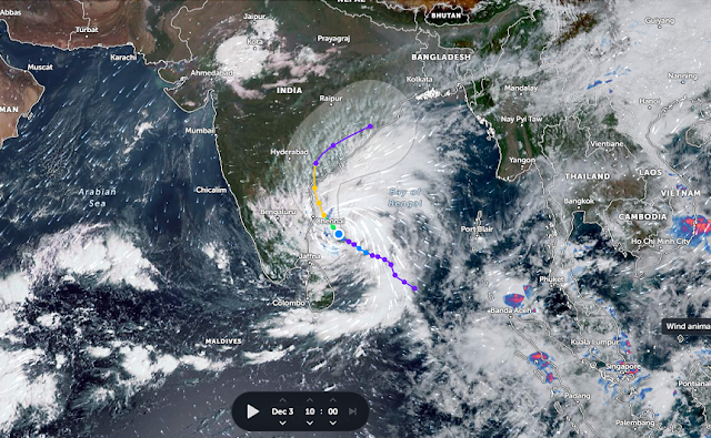
Latest Synopsis :DVANCED DVORAK TECHNIQUE
                    ADT-Version 9.1
         Tropical Cyclone Intensity Algorithm

             ----- Current Analysis -----
     Date :  03 DEC 2023    Time :   033000 UTC
      Lat :   11:42:18 N     Lon :   82:20:00 E


                CI# /Pressure/ Vmax
                2.6 /1005.5mb/ 37.0kt


             Final T#  Adj T#  Raw T#
                2.6     2.7     2.8

 Center Temp : -34.9C    Cloud Region Temp : -63.1C

 Scene Type : CURVED BAND with 0.67 ARC in LT GRAY
              Maximum CURVED BAND with 0.96 ARC in LT GRAY
at Lat: 12:18:00 N Lon: 82:31:47 E .png)
A cyclone will form in the Bay of Bengal by the night of 2 Dec/morning of 3 dec.
This will be the third cyclone of the post-monsoon season in the Bay of Bengal.
For the 1st time after 2018, all the three months (Oct, Nov and Dec) of the post-monsoon season will have a cyclone in the Bay of Bengal.
Multi-model ensemble indicates that due to close proximity with land, this system can maximum intensify up to 90-95kmph.
Due to weak steering the system is currently moving at a very low speed.
This system likley to hit central Andhra coast on 5 December with winds close to 90kmph.
SST in the south Bay of Bengal continue to remain 1-2C above normal.

Weekend ( 2nd - 4th) Outlook:
Mumbai: Days warm around 31°c and nights around 21°c.
Partly cloudy skies possible with smoggy conditions ( due to atmospheric inversion trap). AQI average exp around 150.
November Average 👇

--------------------------------------------------
Gujarat: Localized showers or a thunderstorm possible in parts of Saurashtra and around Ahmedabad, Bharuch, Vadodara, Surat regions during Saturday 2nd and Sunday 3rd December. Rainfall will be unevenly spread30th November

Easterly winds have resulted in a trough extending from Indonesia to Sri Lanka. The embedded Well Marked Low will get enriched moisture.
GEOMAGNETIC STORM WATCH

Solar storm to hit Earth on November 30, will disrupt mobile communication.
NASA and weather experts are issuing
a warning about an upcoming solar storm projected to strike Earth on November 30
This relatively minor storm is anticipated to disrupt radio and GPS.
NASA and weather experts are issuing
a warning about an upcoming solar storm projected to strike Earth on November 30
This relatively minor storm is anticipated to disrupt radio and GPS
Three and perhaps four CMEs are heading for Earth following a series of explosions on the sun this week.
Estimated time of arrival: Nov. 30th and Dec. 1st. The biggest of the CMEs, launched on Nov. 28th, could sweep up some of the earlier, lesser ones, forming a Cannibal CME.
28th November
Light rains 🌧 may continue in Pune and Sambhajinagar next 2/3 days.
Rainfall from yesterday's weather interactions
❖ Significant Rainfall Amount:
Mumbai Lakes (mm) Vaitarna 37, Tansa 47, Vihar 0, Tulsi 9, Upper Vaitarna 33, Batsa 56, Mid Vaitarna 31
➢ Madhya Maharashtra: (cms) Taloda (dist Nandurbar) 15, Jamner (dist Jalgaon) 9, Yaval (dist
Jalgaon) 8, Nandurbar (dist Nandurbar) 7, Shahada (dist Nandurbar) 7, Shirpur (dist Dhule)
7;
➢ Gujarat Region: (cms) Sagbara (dist Narmada) 14, Navasari_aws (dist Navsari) 13, Umerpada
(dist Surat)12, Mandvi (dist Surat) 12, Kukarmunda (dist Tapi) 11, Kamrej (dist Surat) 10,
Narmada_kvk Aws (dist Narmada) 10, Surat City (dist Surat) 9, Surat_kvk Aws (dist Surat)
9, Netrang (dist Bharuch) 9, Nadiad (dist Kheda) 8, Nizer (dist Tapi) 7, Palsana (dist Surat)
7, Ankleshwer (dist Bharuch) 7, Sankheda (dist Chhota Udepur) 7, Olpad (dist Surat) 7,
Modasa (dist Aravalli) 7;
➢ Saurashtra & Kutch: cms :
Chuda (dist Surendranagar) 11;
➢ West Madhya Pradesh: Rama (dist Jhabua) 11, Niwali (dist Barwani) 11, Sendhwa(med)
(dist Barwani) 11, Pansemal (dist Barwani) 10, Rajpur (dist Barwani) 10, Chachariyapati
(dist Barwani) 9, Ranapur (dist Jhabua) 9, Badwani (dist Barwani) 9, Khargone-aws (dist
Khargone) 8, Jhabua-aws (dist Jhabua) 8, Udaigarh (dist Alirajpur) 8, Warla (dist Barwani)
8, Maheshwar (dist Khargone) 8, Kukshi (dist Dhar) 7, Pati (dist Barwani) 7, Kathiwada (dist
Alirajpur) 7, Alirajpur (dist Alirajpur) 7, Bhagwanpura (dist Khargone) 7, Anjad (dist
Barwani) 7, Jhirnya (dist Khargone) 7, Bhikangaon (dist Khargone) 7, Bhabhra (dist
Alirajpur) 7, Sondwa (dist Alirajpur) 7, Gogawan (dist Khargone) 7;
➢ Marathwada:cms
Purna (dist Parbhani) 9, Manvat (dist Parbhani) 8, Parbhani - Imd Obsy (dist
Parbhani) 8, Jafrabad (dist Jalna) 7, Gangapur (dist Chh. Sambhajinagar) 7, Pathri (dist Parbhani) 7, Selu (dist Parbhani) 7;
5th June NLM: Monsoon Rainfall Today Not sufficient Depth for SW Winds and interfere of W.D. may delay further advance by few days. Outlo...


.png)


