Tuesday, April 30, 2013

 Monsoon Watch -3 2013 (Additional)...April 30th.

The arrival date is calculated seeing todays position. Further from today, we presume the normal rate of progress of the Monsoon (In cricket parlance:projected score at the current run rate).


This initial estimated dates are subject to some changes, and will be finalised around mid-May, when the puzzle pieces look well arranged.


As of today, there seems to be a slight delay in both, Arabian Sea and Bay Branches of the Monsoon. There continues to be a doubt on the timely arrival of the Monsoon in the Bay branch.
Bay branch needs to wait a few days for the embedded Lows to fizzle out, and to get going.


Arabian Sea Branch: Though there is some improvement in most of the parameters, there is still much to be achieved, and most parameters are still lagging behind time, and are -ve.
The Arabian Sea branch, may not be affected by the temporary "dis-organisation " in the equatorial winds at the equator. ( Provided they regroup fast).

(Dates in brackets are the normal dates of arrival).
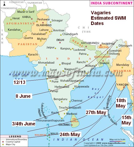
 On these calculations, Vagaries would  maintain the Monsoon to reach Maldives around the 24th of May 2013(20th May), Sri Lanka around 27th/28th of May (25th May).
Kerala by the 3/4th June (1st June).
Hence, maintaining and presuming the normal rate of progress, Goa should get Monsoon rains by around 8th June (5th June).
 

Mumbai by 12/13th June (9th June). Regular Pre Monsoon thundershowers could start from around 6/7th June 2013.

Bay Branch: SWM should hit South Andaman Sea around 15th.May (12th May), and rest Andaman Islands by 18th-20th May 2013.
Generally moves up (normally) the Bay at a sustained speed, and Kolkata should see Monsoon arrival by the 9th of June, along with the NE states.

We stop at this initial progress, and work out further region wise progress at a later date  (as is the usual practice in Vagaries' MWs).

These Dates are worked out and estimated as per my personal calculations and may not be used for commercial purposes.The dates are not binding on anyone and no responsibility is taken if used for any purposes.
Friday, April 26, 2013


Outlook for 29th April - 1st May...on Current Weather Page.

  Hot Weather Warning for Nagpur and Pune !...Mumbai Page..


Monsoon Watch - 3.. 2013 ...26th April 2013

Subsequent to writing the MW-2, a major and unexpected development disturbed our Monsoon Progress in the Sub-Continent. A sudden dipping of the 200 hpa jet streams, a sort of a "Rossby Wave" meandering, created an upper air trough from Pakistan through Kutch and Gujarat and dipped into Northern Maharashtra. The trough, versus the  normal position 8 days ago is shown here.(Map)


Its narrow isobars made an air "parcel" rise up, and the Lifted Index in the region showed a negative 6 figure.

The reason I call it as an upset is because the resultant thundershowers were widespread in NW Sub-Continent, Gujarat, North Maharashtra and, simultaneously, our friend,WD (A-5) moves in and interacts with this trough.
The shading indicates outgoing long wave radiation (OLR; W/m²). The contours show 200-hPa stream function at intervals of 5x10⁶ m²/s.( maps)


Again, snow and rains in the Northern hills.
As a result, and expectedly, the day temperatures fell, and the seasonal low was almost wiped out.

To add to the commotion, an "unfriendly" Low, and associated UAC formed over Oman, bringing good rains and cooler weather from Oman to coastal Balochistan. The very regions where the seasonal Low is supposed to spread its wings into later.


1. Sub-Continent Seasonal Low: Seasonal Low almost wiped out...core pressure at 1006 mb...
The sesonal low in the Thar region is now very weak and hardly can be acknowledged as a "growing" Monsoon Low.
The pressure around the Thar desert region is now 1006mb (994mb required by June beginning). There is no proper central core formed as yet. And ,as per the required scheduled development, a proper gradient  is behind schedule in the making.(Map)


Days temperatures have "performed miserably" in the MW-2/MW-3 inter period ! Below normal temperatures by as much as 18c have been recorded, and the highest on 25th April was 39c in the Sindh areas, and 41c in India. yes, there was an occasional isolated 44.5c, but, we have yet to see a 45c !

An exception this year is the Vidharbha region. Even without the normally exceptionally heavy rains, the temperatures are just about managing 42/43c (till 25th April), and in some cities just hovering around the low 40s. 
Normally Vidarbha is a hotbed ! 45-47c is a "kid's playground" for the region.

In 2011, the minimum temperatures in the region  were higher comparatively at this time. Minimum temperature touched 30c for the first time in 2011on 29th April at Kota (Rajasthan).
In 2010, 30c as minimum was recorded on 17th April.

And contrast this with the night temperatures today.

The max and min temperatures have to rise now. Trends of rising temperatures may be seen again  in Vidharbh, Gujarat and adjoining regions of Sindh across the border.

True, the entire sub-continent region has to suffer a heat wave, but the gains are much more. 

The line of dis-continuity, currently "mis -behaving" due to WDs and upper troughs, should shift back to its normal position, in the centre of the Southern Peninsula region.
 

Out breaks of pre- monsoon thundershowers are expected normally in the southern states and South Maharashtra.  Though the showers in the South are heavy. We need the thundershowers to commence and precipitate in Maharashtra and Interior Karnataka, indicating a proper flow of moisture into the peninsula region.
 

A LWD in the central peninsula region "looks after" the moisture content in the interior areas, and prepares the atmosphere with the humidity required fro a proper and good rainfall in the Lee ward regions.

Indicator: --ve.

2.  Bay Low:
 

Continuing from MW-2, "Bay of Bengal" low pressure parameter is a worrying factor. Normally, the Bay should host a pre-Monsoon low anytime after 15th.April. Like I mentioned in the previous MW, in 2011 we had a cyclone in the Bay by the third week, and in 2009 a cyclone crossed the Bay on 12th April.2012 hosted a low around 25th April (BB-1).

As on today, this region still maintains a luke warm response to the formation of a quick low. The pressure is anything but low, and the winds indicate a weak "high" trying to stabilise itself.

What is needed now is a pulse from the Far East, to start with, and break up the existing high pressure area.
But for this, we may have missed the first bus, as the MJO has entered a weak phase in the Bay region. 


Fortunately, the MJO turns "Neutral" to slightly positive in the Maldives and Maldives region  after 1st May. This will bring heavy rains in that region, giving a "false alarm" of the SW Monsoon, as, with the MJO, the rain patch will move East wards, and this will send  favourable indications for the Bay.
Only +ve sign of a quick formation is that the SST is conducive. Map shows around 32c near the Andaman Islands. Good temperature for quick low formation.

Indicator: -ve


3. Cross Equatorial Winds :

The Southern  high pressure region, the Power House of our Summer Monsoon, is constant down in the Southern Hemisphere, off the Madagascar Island, and in the mid South Indian ocean.
The Mascrene Highs have maintained their strength, and i would say gained to some extent... at 1025mb and 1022 mb.(Map)


The cross equatorial wind flow, has just about picked up in the Western sector Southern Hemisphere. Winds, have not yet achieved the required speeds, but just  hitting the East African coast. To get a defined Somali Current, we need a proper e-curving Northwards of the winds, on the Kenyan coast. (Map)


However, The region below the equator in the Bay sector is almost in the same situation as MW-2,  with SE winds tending to bend SW South of the Bay in the 95E-100E region.These winds are weakened by a Low at 10S and 87E, which has sucked off a portion of the SE winds towards the low itself.

Low will move away Southwards, thereby delaying and off setting the ICTZ again. 
Remember, the normal date for SWM to hit the South Andaman Sea is 15th. May.

Amidst this, no cyclones are likely to form off Australia this season.  If no further low pressure forms there till end of April, the ITCZ can start moving North. Currently it is at 7S. It needs to cross the Equator by 10 th May. 

As the ITCZ tracks north, associated MJO waves can "ride" along with. Meaning, after the shift, more MJO waves in the Northern Hemisphere (read Bay regions).

And with low pressure and ITCZ moving North, the High in the Southern Indian Ocean has a fair chance of getting stronger and anchoring well.Also, the SST anomaly  is favorably tilted in the Southern Indian Ocean...


Indicator: Neutral.

4. ENSO:
ENSO the same as reported in MW 2. Not much significant warming is seen in the region.
The 30-day Southern Oscillation Index (SOI) is +6.5..
 It should remain Neutral for the next 2/3 months.
If, by any chance, the ENSO swerves from normalcy, it would mean more/less than normal rains in June.
Indicator : Neutral

Conclusion: Indicators:  1) Seasonal Low --ve     2)Bay Low -ve     3) Cross Equatorial Winds Neutral    4) ENSO Neutral   


Normally I would put up the estimated Dates of Monsoon arrival in this MW, but, seeing the changing scenario, would like to wait for a few days.
Will put up an additional (brief) MW -4 on 30th April, with the Dates of expected arrival of Monsoon.
Then, we go into analysing the quantum of rainfall expected, in the subsequent MW-5 (which as usual will be in 2 parts), and will be ready for publication on 2nd May

Wednesday, April 24, 2013

 Monsoon Watch-3 will be Published on Friday 26th April ...by 9 pm IST

Posted on Thursday Evening:
Brief Forecast: warm winds from N/NW will be warm in N.Konkan  region next 2 days as High pressure takes grip in sea...very gusty hot winds in Gujarat next 2 days..Goa and adjoining extreme south Konkan and South Mah can get Thundershowers on Friday.


Posted on Wednesday Night...@ 11 pm IST.
Hottest in India: Solapur at 41.1c, Pakistan was Mithi at 39.5c.
Now, attention to Thursday's Schedule of our forecast..A-6 moving in and thundershowers for Northern Pakistan, Northern Indian Hills, Punjab, Haryana, Delhi NCR, Jaipur, Interior Karnataka (Belgaum) and Goa....Thunder heads for the Konkan Belt....and of course Kathmandu, which recieved its shower today, and more tomorrow !

Rains in Oman:


Maps above show the  Low over Oman,extending to 700 hpa heights,  and the subsequent trough at 850 hpa, remaining  practically stationary over the region till Wednesday Morning.
(As per vagaries' Forecast of Monday).

System gathered moisture from the Arabian Sea, and the prevailing High over the Sea sent Westerly winds (Clockwise direction) brushing along the Iran/Pakistan coast up to Karachi.
Rainfall, though decreasing, is expected to linger on till Friday, with thundershower in Muscat. System now is expected to fizzle out.

Day long light to medium rains , with thunder  flooded the Wadis of Oman. 

Highest 24 hrs rainfall till 5 pm IST on Wednesday was in Qaboos Port which measured 20 mms.
Muscat AP saw medium rains and thunder with early morning hails, and measured 11 mms till evening today. The day's high was 30c (6c below normal).
The mountainous region, Jamal Shams, saw a high of 12.5c and an overnight low of 4c, with 19 mms of rain till evening of Wednesday 24th.
Ibri saw a lot of flooding , with a spurt of heavy rains measuring 15 mms till evening and 10 mms yesterday.

All Wadis are prone to flooding even with a small amount of rain there, as the water "overflow" is high, and there is no way it can be channeled off.


Tuesday, April 23, 2013


Posted on Tuesday @ 11.20pm IST.

An Evening Report of Tuesday's Highs:
Highest 41.1c at Solapur and 40.5c at Akola. The light blue shade in the Map of Tuesday's highs shows the hottest region.... comparatively small for this time of the year with lower than normal  temperatures.


Hotteste in Pakistan was 39c at Dadu.

Thundershowers occurred on Tuesday in 1/2 places in W.Bengal (Chanbali and Kolkata 1 cm), AP and a few places in East Vidarbha (Nagpur 5 mms) and S.I.Karnataka,and in Kerala.

A-6 has formed an induced UAC over Rajasthan. Likely to move Eastwards, and cover precipitation over N.Rajasthan and adjoining Punjab, Haryana and parts of Delhi NCR.

A LWD from the UAC runs Southwards (in lower levels) across west MP, Vidarbha, Marathwada into Interior Karnataka.
accordingly, the precipitation forecast map was given yesterday.

In the meanwhile, Ibri in Oman received 23 mms, Jabal Shams 13 mms and Muscat Ap 2 mms till Tuesday morning.

Quetta in Pakistan measured 31 mms, and Khuzdar 19 mms.

x---------------------x----------------------------x----------------------------------------x--------------------------x
Posted on Monday 22nd:(Below)
Cooling to "Cold Wave Levels" in NE India;

Day temperatures were very low in UP and adjoining regions on Sunday 21st April. This map shows the region of below normal temperatures on Sunday...some prominent below normals.
Bareilly - 29.9 C (-9 C), Lucknow - 26.3 C ( -13 C), Varanasi - 25.0 C ( -15 C) Allahabad - 27.8 C ( -13 C),Gorakhpur - 21.5 C ( -18 C).


The unusually low day temperatures is shown here in the Maximum temperatures map for Sunday 21st April.

In the last 3 days, some regions of Gujarat have received as much as 80-90 mms of accumulated precipitation.
Reports of rain/Thundershowers were received from Saurashtra, Baroda, Surat and Bharuch.

Sindh region in Pakistan had good rainfall on Sunday 21st and Monday 22nd. Till Sunday morning, Hyderabad (Sindh) measured 21 mms, hotspot Jacobabad saw 12 mms, Rohri had 7 mms.Islamabad had 7 mms of rain till Monday morning. 
On Monday 22nd, Karachi experienced a thunderstorm. several regions of Sindha and adjoining Kutch in India had heavy showers, with Bhuj receiving heavy showers Monday evening.


Briefly next few Days:
1. An UAC over Oman, Southern Oman , will bring heavy showers in Southern Oman, and fairly good rains in Muscat on Tuesday , Wednesday and Thursday.

2. A perpendicular Line of Wind discontinuity  will bring showers in the regions shown in the Vagaries' Map below. Rain Chart valid for Tuesday 23rd through Thursday 25th
Can expect a drifting thunderstorm from the East into Goa and Belgaum on late Wednesday/ Thursday night.

3. WD A-6 moves into Northern Pakistan and Northern India from 23rd Apri for the next 3 days.. Rains will be covering Northern Pakistan, Pakistan Punjab. 
In India, Kashmir, Punjab, parts of Northern Haryana, HP and Utterakhand.
I would expect a thundersquall in Delhi NCR with rainfall in some parts on Thursday 25th. Surrounding Northern Rajasthan (Jaipur and Southern regions of Jaipur) and adjoining UP too may get Thunder squalls in some regions.

Nepal gets good rainfall on the 3 days from Tuesday thru Thursday.Kathmandu getting the evening thunderstorm which may be heavy.

4. After a good 4 day spell, rainfall decreases totally from Gujarat and MP from Tuesday.  


Mumbai: Partly cloudy skies, with towering cumulus "fluffy" clouds. Night temperatures expected to  rise. Temperature in the 33-24 range for Santa Cruz.
Outer townships see a rise in day temperatures with cumulus clouds. Some far thundery developments on Thursday in the E/SE direction.


New Delhi: Hazy skies, with temperatures gradually rising back to 40c by Wednesday..Thursday evening could see some thundery developments in some parts with rain in some parts.

Goa: Partly cloudy, and a thunderstorm possible on Wednesday/Thursday.

Surat: Back t sunny and hot days, rising back to 38c by Wednesday.


Sunday, April 21, 2013

Vagaries' Meeting at Thane on 19th April 2013.


From Left, Ronnie Bhaumik, Mohan, Rajesh, Puneet, Rohit, Abhijit, Salil and Gurvinder.....

Thursday, April 18, 2013

Mumbai Santa Cruz Analysis of 50 days of Summer (half the Total days)...from Rohit...See Stats and Analysis Page

Monsoon Watch - 2   (18th April 2013)

Further Analysis of the parameters as discussed in MW-1. 

1. Seasonal Low: As the average day/night temperatures in the Northern/Central Sub-Continent areas have  shown a distinct warming up, and  the -ve factor from the previous MW (last week) discussion shows some improvement (though still -ve). Heat waves are seen in the Central Regions and Eastern coast now.

 Last week's map of day and night temperature average of the anomaly explains this. Slightly bove normal in Northern/NW and Central Sub-Continent. 
But, the point to note is the "white" region stretching down from Western Rajastahn thru Western Maharashtra into Karnataka. This is attributed to the persistent below normal night temperatures. A prominent "white" is also seen in the East/Central region last week.

However, comparison with previous years shows the difference this years. In 2010, the first 45c touched on 10th. April, and on the same day Nagpur was 44c, Delhi 42.8c. Soon on 15 th April 2010,  Nawabshah (Pakistan) soared to 47c, Simla to 28.2c on 16th, Ganganagar, Akola and Hissar to to 46c. 
But, 2011 and 2012 were similar to this year. This year also, we are yet to reach 45c anywhere in the Sub-Continent, as was in 2011 and 2012. Into the 3rd. week of April now, and a prominent heat wave is missing.


As on 18th. April 2013, the lowest pressure, in the Thar Desert region is at 1002 mb. (though 2011 was 1006 mb, 2010/2012 was at 1002 mb this time) and this "low" region is restricted to a small area. As mentioned, it normally should reach a low nadir of 994 mb in June, and with 1008mb in the South Arabian Sea, a perfect gradient is created to attract the south -west winds towards the coast.

Rest of NW India too shows a marginally Higher reading of 1004/1006 mb
The quick formation of an optimum Seasonal Low was delayed due to persistent A-3 and A-4, and absence of heat wave in Central and Northern regions of the Sub-Continent.

Thunderstorm activity in Southern Tibet is also seen to be picking up.

Indicator: -ve

2. The ENSO is neutral in the Pacific Ocean, with a further warming of the SST in the past 2 weeks. NINO 3.4 is warmer by about 0.1c, but NINO 3 is cooler by 03c over the last 15 days. 
The SOI is at a high level at but remains within values indicative of neutral ENSO conditions. The latest 30-day SOI value is +5.1.


Indicator: Normal.

3. Last week, the Cross Equatorial winds, which originate from the Southern Indian Ocean as SE winds, and cross the equator to become South-West, were weak, and not developed due to the cyclones in the Southern Indian Ocean. With both the cyclones being a spent force now, we see the re-organisation of the Southern Hemisphere SE winds, as no hindrance is seen to occur now.

Let me explain, that the winds on crossing the equator break into 2 branches. 1) gushing into the Arabian Sea, and 2) moving into the Bay of Bengal. 

In the Western Sector, the Arabian Sea branch is still struggling to get organised. Here, sufficient wind speed off the Kenyan coast has yet to form the SE flow required. But should re-organise fast. SE winds are now getting organised and weakly striking the East African coast between the Equator and 5N, though still weak. 
The Northwards movement of the ITCZ will surely hasten and strengthen the winds.


Today, we find, in the Eastern Sector, the winds south of the equator better organised for the Bay branch, in the region south of the Andaman Sea. SW Currents are seen off the Sumatra coast. Thunder cloud (Cb) developments are seen near the region South of the Equator.
And that is exactly where the start should be for the SWM to arrive at the Andamans. Upper winds at 100-400 hpa are vigorously aiding the lower winds to attain the required strength.


Currently, the weakening "Imelda" depression has created a "damaging" trough and pushed it Southwards, literally breaking the Mascarene high pressure zones in the South Indian Ocean. Main High reading now 1029 mb, and 2 more Highs (in the forming) have been observed, one at 1018 mb and another at 1025 mb. between Madagascar and Australia. The "Power House" of the Monsoon winds is slightly behind schedule, for this time of the season.

Indicator: -ve

4. But the pre Monsoon Low in the Bay is still elusive. As discussed, we should normally see a low sometime after the 15th. of April. The high pressure region in the Bay, at sea level, no longer prevails. Never the less, the encouraging factor is the likely formation of an UAC in the Andaman Sea. 
Seeing favourable winds, and a slightly positive MJO still in the region, we see this as favoring a low formation. But, it has to be quick, as the positve MJO moves away Eastwards by the 25th. It is forecasted that a negative weak MJO phase may settle in the Bay region last week of April.

Another factor, which helps the winds gain strength, and bring more moisture into the Indian landmass, is the sea temperatures on both sides of the Peninsula. Optimum (warm) temperatures will hasten and create more clouds, and help in faster forming of the lows from the Bay. 
This parameter, "normal" and tilting towards  "favourable" as on date.


I have put up the SST of last year on date. Comparison with this year shows it is favourable in the South Indian Ocean, where cooler waters will create a High pressure quicker.
Indicator: Normal

5. To bring the existing SE winds above the equator, the ITCZ should move northwards. Around 1st. of May, this should cross the equator. The ITCZ should now come back to its Northward position, as the effectives "Lows" created by the Rossby Wave have fizzled out. The Western end is still dipping to around 5S, but the Eastern end has moved Northwards and is almost at 10S.


Indicator: Normal

So, overall, we can summerise as:
Parameter:1)  Normal,   2) Normal.  3)  -ve,   4) Normal,   5) Normal.

Most parameters are "Normal" as of today. 
In today's situation, Monsoon arrival in Kerala could be on normal dates in Kerala and the Bay Islands, and the NE states. 
We will put up the estimated date of arrival in the MW-3.

But, situations can change fast, and by the time we discuss the next MW, some factors can suddenly become +ve or -ve. So, MW discusses and follows the developments as they emerge, and discuss the parameters as is where is. 
No model can commit from today when the Monsoon can arrive. Quantum of rain forecasting in the month of  April,  for a period right through September is an impossible task. 

Next MW up on 26th. April with firm Dates of Monsoon Arrival.

These reports are my personal views, study and observations. Estimates and forecasts are also my own calculations and views, and may/may not tally with any other estimates. This may not be used for commercial purposes. The author is not responsible for any commercial loss from this article, or this series of articles.

Wednesday, April 17, 2013


Welcome to our 2nd Meet, bigger and Better this time :-)
Vagarians Meeting on Friday 19th. Venue: Cafe Coffee Day, Korum Mall, Panch Pakhadi, Thane (West)...Time: 5 pm...open to all Vagarians. 


Flash Forecast for Thursday and Friday:
Thursday 18th:
Very heavy rains likely in Western Bangladesh. Strong Winds and hailstorms likely. 
Adjoining Central W.Bengal can get strong thunderstorms. 
Kolkata vicinity could be lashed by heavy thunderstorm on Thursday. Strong winds likely.
Light rains likely in some parts of Central Saurashtra. Clouds developing around Surat. 

Friday 19th: Heavy Thunderstorms in Bangladesh and adjoining Meghalaya. Gangetic w.Bengal can get thunderstorms. 
Kolkata will see thunderstorms with squally winds.

Gujarat region will be cloudy. Eastern parts of state will receive showers, with heavier falls in the Ahmadabad-Vadodra region. Surat will be cloudy with showers in some parts. Bharuch too will get light rains. Light rains possible in Rajkot and adjoining Central Saurashtra.

Nasik district and Vidharbha in Maharashtra can get thundershowers in the evening.

Thundery developments will be seen in the Eastern skies of Mumbai. Outer townships will get partly cloudy in the evening with thunder clouds in the East over the Ghats. 

In Pakistan, fairly heavy rains are likely in the region North/NE of Karachi. Hyderabad will be cloudy with light showers. Rest South Eastern Sindh will be cloudy.

Wednesday, April 10, 2013


Monsoon Watch - 1... 2013

These reports are my personal views, study and observations. Estimates and forecasts are also my own calculations and views, and may/may not tally with any other estimates. This may not be used for commercial purposes. The author is not responsible for any commercial loss from this article, or this series of articles.

The Monsoon developments, as they unfold, will be analysed and discussed and explained in Vagaries. 

Do you know, the South West Monsoon is just about 35 days away from its normal date of arrival from the shores of India ? Yes ! its just 35 days from the Southern most point of India on the South Andaman Islands, Indira Point, where the normal arrival date is 15th May.
And its about time we start the follow up of its progress and monitor its developments. 

The Sub-Continent is eagerly awaiting for its share of 2013 monsoon rains !

This annual series is a follow up and chasing of the South-West Monsoon. Every article in this series explains the synoptic situation as it actually is, and based on the day's position, the date and quantum of rains as on THIS SITUATION.

It is very important to firstly estimate the date of arrival of the S W Monsoon, as year to year, variations in dates of onset of the monsoon can occur and there have been several occasions in the past when the monsoon arrived over certain parts of the country about a fortnight earlier or later than the normal dates. 
The SWM has the  weatherman tearing at his hair for the exact date or time, extent and progress. This is never 100 per cent sure though various weather models are used to calculate this event.

Initially, in the first  few articles, this series will be chasing and closely following up the actual developments of the monsoon parameters, and analyzing its progress regionally for calculating and estimating the arrival date. 
We are not yet contemplating the quantum of rains or the monsoon strength as yet. 

There are 2 parts to this article:
A)-This is the Ideal Conditions (Map) During SWM Onset in Early June. and 


Vagaries map

B) below indicates the actual situation of the parameters situation today (10th April).

A) Very very briefly, let  us first understand, that the "power house" of our SWM is actually based far away in the southern Hemisphere. The main "generating factory" is the Mascarene Highs, between SE of the Madagascar coast and Australia. The SWM is born down South, 4000 kms from the Indian Mainland !

The proper formation of these high regions,(1032/1034 mb at least) will boost and create proper SE winds to lash the East African Coast near the Equator, and then turn perpendicular towards SW in the Northern Hemisphere. 
And the formation of the "Tibetan High" is another factor. An anti-cyclone in the upper atmosphere over the Tibetan Plateau. During the formation stages, there will be thunderstorm activity in the SE parts of Tibet during the months of April and May.

To generate a powerful  SW wind, the cross equatorial flow must be strong and gusty. SW winds (ultimately upto 600 mb levels) then are capable of riding on the warmer Arabian Sea waters (Arabian Sea Branch of SWM) and bring cloud masses towards the West Coast of India. In the Bay, similar SW winds are generated (Bay branch of SWM), but from SE winds below the equator, just below Sri Lanka.

And to attract the SW winds, again, we need a good proper "seasonal low" to develop in the Sub-Continent. This seasonal low, normally should start forming around Barmer, Rajasthan, by mid April, and at its peak stretch upto Arabia. Seasonal low at its peak, in June, should normally be around 994 mb, and the ridge around Kerala should be 1008 mb. This enables a good gradiant to pull the SWM Northwards and inland.

B)-In this initial stage, we will observe the basic root and foundation, the initial 4 parameters only, and the initial seed of the monsoon. From these parameteres, later a few more develop.

1. Cross Equtorial Winds from Southern Hemisphere.
2. Seasonal Low over India/Pakistan.
3. ENSO Status.
4. Pre Monsoon Low in the Bay.

Position today:
1. Cross Equatorial Winds should normally  start forming, and taking shape from mid -April, especially in the South Indian ocean region. 
The Mascarene Highs are the main "Power House" of the South -West Monsoons. This generates the South -East winds, which after gaining strength, cross the equator and become south west. For a proper High to form in the South Indian Ocean, the cyclone season (Low pressures) should completely die down from that region.

As on date today, the Mascarene Highs is forming, though in initial stage, and 1 segment, of 1034 mb is seen. (Map Below)


But things are messy below the Equator.
Currently the MJO has stalled in the Eastern Indian Ocean region, with 3 embeddded lows.

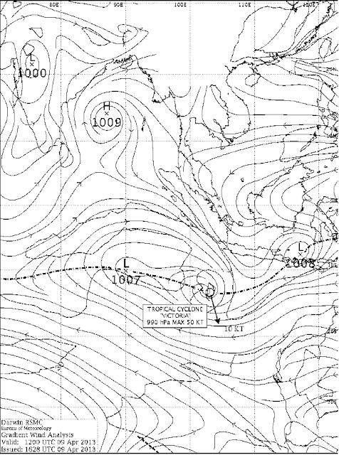
For the Bay branch, we have an interaction of a Rossby Wave and the MJO, which has formed a cyclone heading towards the NW Australian coast. 


Aust Bur of Met

This Cyclone "Victoria" is expected to move Southwards, and further pull down the trough towards the South. Tropical cyclone forming in the S.Indian Ocean off the Australian Coast, means a marginal delay in the Mascrene highs strengthening. ..ITCZ today is around 7S.

Initial forming off the East African Coast, has been disturbed by another Cyclone "Imelda" off the NE coast of Madagascar. The winds are pulled towards the cyclone, and re curve back from the coast in an anti clock wise direction around the circulation. 
Part of the SE winds today converge back Eastwards towards the system (in the trough) NE of the Madagascar Island, South of the equator. 
The winds are Northerly above equator right down till 5S.


Yo Surfer wind Charts

As the Monsoon strikes the Andaman Sea by mid May, developing wind currents are required to be observed initially near the Eastern side of the Southern Indian Ocean, and this is weakly forming as of today, but disturbed by TC "Victoria"
Indicator: -ve

2. Seasonal Low: Now, this year, the heating in the sub continent has just about started in the Eastern regions. The above normal heating in the NW is yet to start, as March was relatively normal I would say. The anomaly map for March shows a warm North, average Central regions and cooler South. This is not much of a plus point in the formation, or a quicker formation of one of the important pre monsoon weather requirment, the seasonal low. In fact, the minimum night temperatures are still below normal in central and NW India. 

The current one week into April is also pretty much the same.


The seasonal low, stretch over Arabia thru India, normally starts forming in the Barmer and adjoining regions in the second week of April. 

Today, the MSL is around 1008 mb in the Sindh/Rajasthan region. There is a isobar of 1008 mb covering almost the entire Indian region.In the "core seed" area, it 1006 mb. (The ultimate low in the core, in June when ready, should be 994mb.). 

This progress is fairly ok. The Line of Wind Discontinuity should stabilise around Central India perpendicular down into the Southern Peninsula by mid April. This enhances the speed of the Seasonal Low formation. Normally is required to start taking shape for the monsoon by the second week of April. 

Indicator: -ve

3. ENSO is now Neutral. Last SOI reading observed was +9.0.  

The Oceanic Nino Index (ONI) is based on SST departures from average in the Niño 3.4 region, and is a principal measure for monitoring, assessing, and predicting ENSO. The readings for the last 2 weeks is constant, no change. Thus Neutral conditions prevail. Neutral conditions expected till June at least, so this parameter will not disturb the advance and will not interfere with the date.
Indicator : Neutral

4. Another pre monsoon seasonal normal requirment is the creation of a low in the Bay by the second week of April. This is necassary to trigger off the flow and formation of lows from the bay.
Progress this year is bad, as the Bay shows no signs today. No forecast of any low as of now. (in 2009,a low formed by the 12th. of April, and later it intensified into cyclone "Bijli", 2010 had no low till 3rd week of april).
Today, we have a "high" sitting in the Bay. The required SW winds may not yet form at least for the next 3/4 days, as the active trough still around 10S is interacting with the MJO.

Indicator:  -ve

Summary for arrival Date: Parameter 1). -ve.  Parameter 2). -ve,  Parameter 3). Normal.   Parameter 4). -ve.
Tilted towards the negative, as of 10th April.

New Readers, please note, These initial Parameters are normally (every year) considered in MW Series to guage and estimate the arrival date of SWM, not strength. Time of arrival normally indicated in MW-3, and strength after 24th April. There are more parameters are to be considered, as and when they are developed and to be taken into consideration.

Next update on 18th. April.

While IMD still defers its forecast, they should have taken up this job in right earnest much earlier. 
Vagaries had mentioned this earlier here last year.. ....March 19th 2012

Sunday, April 07, 2013

Vagaries' annual Monsoon Watch Series will Commence on the Usual Date this Year. First Article under preparation and compilation now, and will be published by evening (IST) of 10th April.

Tuesday Highs in Sub-Continent:


Hottest in India on Tuesday 9th April, Allahabad at 43.2c...Now, does this not tally with the Red patch in vagaries Sunday Forecast over Southern UP....followed by Anantapur and Nagpur at 42.7c.
Ahmadabad and regions to the West had a light drizzle on Tuesday afternoon/evening. Rain region effected Eastwards than the predicted zone..
Mumbai colaba 30.6c, Vagaries 31.3c, Scruz 32.0c..and Mahableshwar still heading skywards...33.8c..Pune 38.9c and Lohagaon 40.5c.

Tuesday's highest temperature in Pakistan was at Lahore at 35.5c., and Nepal hottest was Birendranagar at 38.4c, followed by Dhangadi at 38.2c. Kathmandu was 31.8c and 13.0c as the minimum.
Aurangabad minimum at 25.6c, +4.6c above Normal...and again, Ratnagiri at 19.5c was 4.8c below normal.

Monday 8th April

Hottest regions on Monday in the Map marked below (yesterday's post)

India's hottest remains in Vidharbha region. Chandrapur at 43.2c...Region is recording many stations above 40c...Amraoti and Nagpur 42.8c, Wardha 42.9c, Akola 42.0c. In MP Khajuraho 40.8c and Raipur in Chattisgarh 41.0c....


Mahableshwar shoots up to 33.0c, while Mumbai Colaba is 31.4c, lowest maximum in state. Ratnagiri at 19.2c (minimum showed the largest deviation at -5.1c below normal.


Karachi had brief thundershowers on Monday, recording 23 mms ...and Hyderabad (Sindh) with a high at 30c recorded 7 mms in the day. Nokkundi gauged 30 mms.

....see pics on Inter Active Page 

Sunday Post:
All ok as per our last weekend forecast, permitting us to move into the next week now....

We see A-2 approaching Western and Southern Pakistan. The induced low over Oman will move NE, and cross the Sindh coast on Monday. The low will then merge with the WD trough, also alighned towards the NE direction.


Hence, on Monday 8th April, we see precipitation in Southern Sindh region, and due to the Low, we see a light "spill over" of rains into the Western most parts of Gujarat (Kutch). 
Karachi gets thundershowers with Westerly winds gusting. Sukkar can get a dust storm or thunderstorm on Monday night.
Thundershowers prevail in Southern kerala. In the NE, Shillong hills can get the thundershower.

Heat in Vidharbh and adjoining AP.
On Tuesday 9th, the precipitation moves NE into Central Sindh in North Pakistan and in India, Kashmir, Punjab, West Haryana and Northern Rajasthan. It seems that thundershowers will occur in all North Rajasthan and West Haryana and Punjab. High clouds obscure sky in Delhi NCR. 
Islamabad gets showers, alongwith cities in Central and upper Sindh, and Pakistan Punjab.
Hot and above 40c in Vidharbh region and adjoining AP.

Heat moves into Southern UP:
Wednesday,10th and A-2  moves NE and rains decrease in Pakistan. Moves into the Northern Hills of India. We see precipitation in Kashmir, HP and Punjab. 
Though cloudy weather for Haryana and Delhi NCR, i do not think any meaningful rains will occur.
In the NE , Meghalaya gets thundershowers and Kerala in the South. Thunder activity continues in West Vidharbh also.
Hot, and above 42c in Vidharbh, adjoining AP, Chattisgarh and Orissa. Above 40c region spreads to North MP and adjoining UP.
Southern UP regions may be in the heat wave grip, with temperatures over 40c.

Thursday 11th, and A-2 has moved away. NE thundershowers intensify. Some local thundershower active in Southern most MP and South Bihar. Not much rainfall seen in the Sub-Continent on Thursday.
The odd thunder activity is possible in Northern Mah districts of Jalgaon and Akola, and adjoining Southern most MP.


City Forecast for next 4 days, 8th, 9th, 10th and 11th April: Nights getting Warmer.


Mumbai: Sunny weather, with some clouds in the morning hours. Day and night range at Scruz will be 32/33 and 22c. Colaba warms up at night to 25c.
Outer townships will continue in the 36/37 range, with nights getting warmer by 2/3c from current range.


Pune : Very sunny and warm..staying steady around 38/39c, but nights warming up to 19/20c levels from the current 16/17c.


Delhi NCR: Chances of some light rain (traces) in some parts on Tuesday Night or Wednesday morning. Days will get hotter from Wednesday, maybe touching 38/39c.

Surat: Sunny and clear, with the days at 35/36c. Nights rising to 24c.


Kolkata: Getting warmer, and possibly touching 40/41c by Tuesday.


Nagpur: Very hot days, around 42/43c. Extra precautions against heatstroke advised. Evenings on Tuesday/Wednesday may get cloudy and making the night temperature rise to 25/26c.

Thursday, April 04, 2013

Massive Storm with "frightening" lightning currently on in Dubai...Posed @10.40 pm IST .Heavy Rains in Northern Oman and light rains in Muscat..Pics on Inter Active Page

Top 50 DISTRICTS RAINFALL MARCH 2013....compiled by GSB..on Stats and Analysis Page


Temperatures on Saturday: Hottest maximum and hottest minimum in India was Kurnool at 42.5c, with the minimum at 29c. Followed by Bhubaneshwar at 42.0c and Tiruchchirapalli at 41.8c. Almost all in the deep Red zone marked in Thursday's weekend forecast.
Hottest in Maharashtra was at Parbhani which saw 41.8c. Pune shooting up slowly to 37.8c

In Pakistan too, as forecasted, the Sindh region is heating up, with Nawabshah the hottest at 40.0c. In Nepal it was Dipayal at 36.4c. Kathmandu was a pleasant 29.5c and night at 9.4c.

Quote from IMD (Saturday evening special Bullettin): "THE TROUGH/WIND DISCONTINUITY IN THE LOWER LEVELS FROM ODISHA TO SOUTH TAMIL NADU ACROSS INTERIOR 
ANDHRA PRADESH PERSISTS(.)"
The forecasted low has formed in the LWD in around South interior AP. Low is at 1000 mb.


Posted on Friday @ 10.15pm IST: The weak trough in Central India is likely to shift East, running from East MP thru Vidarbha/Chattigarh and AP. A weak Low embedded in the trough may form in Southern AP by Saturday night.Low may survive only for 24 hrs in Central/Southern AP.


Closely behind is another WD, A-2. The trough from the system will bring rains on Saturday 6th April to Dubai. 
Saturday night and Sunday 7th day time will see precipitation and cloudy weather for Muscat.

Sunday night sees fairly heavy rains aalong the Gwadar coast of Southern Pakistan. 
Sunday night and Monday 8th, morning, heavy thundershowers with squally winds can be expected in Karachi. 
Sukkur can get a thundershower and Hyderabad will be cloudy with chance of a shower on Monday 8th April.

Weekend rains will be subdued in Southern peninsula and rest of India.

A-2 moves into Indian region from Tuesday 9th April.


Heat Wave likely in Vidharbha and adjoining AP regions. Temperatures in AP and Vidharbha likely to touch 43c by Sunday.

Weekend for cities:

Mumbai: Partly cloudy mornings. Temperatures around 32-21c (Scruz). Humidity increasing and creating more sweaty conditions. Humidity increasing, and sweaty conditions start.
Outer townships will have cloudy mornings with warm days around 37c.

Pune: Very sunny and hot weekend with temperature touching 39/40c.

Nagpur: Partly cloudy with afternoon convection. But hot day, possibly touching 42c by Sunday.

Delhi NCR: Sunny weekend, with rise in day temperatures. Expected to reach 37c by Sunday.

Kolkata: Partly cloudy with mercury touching 39/40c by Sunday.

Surat: Hot and sunny. Saturday will be around 36/37c. Sunday will see good westerly breeze.

Let's look into the 3rd week of March ( 17th - 21st). Mumbai : Hot weather likely for Mumbai region this week, typical dry hot days of M...