Saturday, April 30, 2022

Jacobabad (Pakistan) Hottest Place today in the world..touched 49c.

India Top 10 on 30th


Outlook for Next Week...Posted 30th April..Evening

Slight Relief Expected in North India from the current Heatwave...

Delhi: The Last 8 days....well above 41c and peaking at 44c...

3rd May - 8th May

With the expectation of dust Storms and some rain, Delhi can get relief from 3rd May...maybe till 8th May..😮...Days could be around 39c-41c.

 Compare the Expected map (Below this map) with the Current..the Orange (42-45c) area contracts
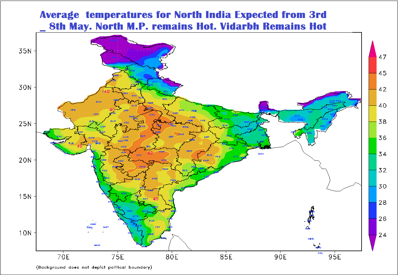

maps IMD

2nd May - 7th May

Vidharbh and Marathwada will remain in the 43-45c Range.

Mumbai: Next week , Cannot expect Mumbai to get less hot , taking the current range of days around 34/35c. At the most 33/34c, but humid it will remain. With a good sea breeze, nights might improve to 26c from the current 28c. But sweat and stuffiness remains in this coastal metro-city.

Pune: Next Week, A stray thundershower in some parts might cool down the area, but expect around 38/39c  next week.

Gujarat: Next Week.

Ahmedabad/Baroda/Rajkot reimaging hot around 41-43c...But Surat and coastal Gujarat will be moderate at 35-37c.

Bharuch will be around 40-41c.


Friday, April 29, 2022

 The Heat Position on 28th April ..2022


Compare and See with Last Year same period..⇊


Tuesday, April 26, 2022

  • Revised IMD Rainfall Normals..And how the new Normals would compare this year ( 2022).
  • The New IMD All-India rainfall southwest monsoon season normal  is based on Data from 1971-2020. For the SWM Season ( June-September) is 868.6 mms. It will replace the earlier normal of  880.6 mms based on the period 1961-2010.
  •  Thus there is a decrease of 12.0 mm season and 16.8 mm in annual rainfall 2010 to 1971-2020. 
  • IMD estimate of SWM this year 2022 is 99% ..or Normal which ranges from 96%-104% of current values.
  • So 2022 expected to reach 858 mms as per changed norms. This would mean 97% of the older Normal.
  • That fit just in the Normal range 96% - 104% 
  • Normal range is quite large : 833 mms- 902 mms  (New )
  • & 845 mms -  916 mms ( old )
  •  The New All-India annual compared to earlier normal of  based on Data from 1971-2020 is 1160.1 mms. It will replace the earlier normal of  1176.9mm based on the period 1961-2010.


Monday, April 25, 2022

Posted 25th Afternoon:

Summer heat to intensify over the country, close to peak summer heat expected!!  

Outlook for the remaining days of April 25th -29th::

With no major Western Disturbance expected in the remaining days of April, the weather is likely to turn extremely hot and dry over northwest India and adjoining Pakistan. Temperatures in the Thar desert towns would hover around 45C, with some places touching 47-48C. Hot and dry winds - 'Loo' like conditions possible in some areas. 


Northwest Indian regions of Punjab, Haryana as well as the Delhi NCR would see daytime temperatures around 42C, with some places touching 43-44C. 

Most of Maharashtra would see hot and dry weather, with Konkan coast being humid. Some patchy thundershowers likely over south Madhya Maharashtra and adjoining south Konkan. 

Summary of max temperature forecast in the subdivisions in Maharashtra:

Coastal Konkan (Including Mumbai): Max around 35-36c, slightly delayed setting in of sea breeze in North Konkan. Very Humid.

Nights around 25-26c.

Interior Konkan: Hot daytime with max around 40c, some parts may see 42-43c further away from the coast towards Ghats. 

Madhya Maharashtra (Pune/Nasik): Hot and dry, max around 38-41c range. Nights around 22 - 24c.

Marathwada: Very hot and dry, max around 42-44c. 

Vidarbha: Extremely hot and dry, max around 44-46c. Warm Nights around 26-28c.

Gujarat: Overall All regions Day to Heat up by 2-3c from this levels of 24th..                                                                                 ↲  


Friday, April 22, 2022

Thunderstorm/Hailstorm lashed parts of Maharashtra on 22/04/2022

Thunderstorm/Hailstorm lashed Satara district today(22/04/2022). Some readings from the district below in mm:


1.DhomDam:68

2.Mahabaleshwar:44

3.Koyanananagar:33

4.Moleshwar:31

5.Sandvali:29

5.Pratapgad:26

6.Kaas:25

7.Patharpunj:17

8.Urmodi:16

9.Thoseghar:14

10.Jor:13


Thunderstorm lashed Pune district today(22/04/2022). Some readings from the district below in mm:


1. Shirgaon:29

2. Saswad:17

3. Bhatghar:11

4. Vir:10

5. Hirdoshi:8

6. Morgaon:5


Data Credits: RTSFROS

Compiled by: Vagarian Abhishek Apte

Wednesday, April 20, 2022

Outlook for Maharashtra and Goa till Sunday 24th April 2022 - Summer heat continues, but with a possibility of thunderstorms! 


In the coming days :21st - 24th, the Madhya Maharashtra belt of 

Nashik, Pune, Satara, Kolhapur, Solapur and Sangli would see some rain/thundercloud development post noon (as Line of Wind Discontinuity (LWD) extends north from Karnataka.) Days will be hot around 37-39°C, and more hotter around Solapur (40-41°C). 

Western Ghats belt from Tamhini till Amboli and adjoining foothills in interior Konkan could also see rain/thundershowers in some parts towards evening, after hot and humid daytime weather.    

Vidarbha would be hotter with most places seeing  42/44°C max temperature. Hot weather with daytime temperature  40/42°C for Marathwada (Aurangabad).  Some  Rain/thunderstorms likely in parts of Latur, Beed, Nanded, mainly between Thursday 21st and Sunday 24th April. 

Outlook from 21st-24th April; 

Mumbai MMR: Hot and humid summer weather with max/min range around 34°C/25°C. 

Eastern outer townships more hotter. 

Pune: Hot daytime with max around 37-38°C, chance of rain/thundershowers post noon in some parts, although not uniformly spread. 

Goa: Hot and humid weather, with possibility of thundershowers by evening. Temperature range 34/26°C.

Mahabaleshwar: Partly cloudy with afternoon Rain /Thundershower likely on 21st/22nd. Cooler days around 29/30c and nights cool at 18c after the rains.

Some light rains likely in South Gujarat Coastal towns of Surat & Valsad on 21st/22nd. 

Bharuch will be cloudy. Hot around 40c, but light rain possible on 21st.

Tuesday, April 19, 2022

 18th April...Mumbai Lakes/Water Position as per Latest Update

  • 36.76%
    Combined live storage across all lakes compared to 33.56% same time last year. 532,105 million litres - Live storage as at 6 am 07 Apr 2022.
  • End August
    Number of days of supply left in all lakes combined (@ 3,850 million litres BMC supplies to city each day
  • Last year on 07th April 2021 was 485773 ML (33 %) of the total 1447363 ML.
  • Mumbai receives freshwater supplies from various lakes and dams such as Upper Vaitarna, Modak Sagar, Tansa, Middle Vaitarna, Bhatsa, Vihar and Tulsi.

    2021-2022


    The water level information source is from Hydraulic Engineer’s Department of BrihanMumbai Mahanagarpalika.


Saturday, April 16, 2022

 Water Situation & Outlook for Maharashtra: 16th April 2022

The Month of March has seen unusual and extreme heat in Maharashtra...specially longer periods of time, rather than high record temperatures. This has depleted and reduced the soil moisture required for proper commencement of farming in June.

The Map below shows the Satellite Image of Soil Moisture prevailing and change expected (Maharashtra).

COLA

The Pre Monsoon Rainfall was also less in the State:


IMD

But this typical and somewhat expected in April..

Now, let us see the actual water reservoir level .Credit Maharashtra Water Resources Dept


  • 23,550,320 million litres
    Maharashtra State. At 58.4% of its full capacity of 40,604,000 million litres, compared to 48% at the same time last year. The state has 141 major dams and 3267 dams and irrigation projects in all.

Overall better than Last year. With proper and systematic Water management, and with favourable weather conditions, the water position in state may not get into serious shortfall by the time the Monsoons arrive.

१६ एप्रिल २०२२...
महाराष्ट्रासाठी पाण्याची स्थिती आणि दृष्टीकोन: 

मार्च महिन्यात महाराष्ट्रात असामान्य आणि तीव्र उष्णता दिसून आली आहे... उच्च विक्रमी तापमानापेक्षा जास्त काळ. यामुळे जूनमध्ये शेती योग्य प्रकारे सुरू करण्यासाठी आवश्यक असलेली मातीची आर्द्रता कमी झाली आहे. 

 खालील नकाशा जमिनीतील ओलावा प्रचलित आणि अपेक्षित बदल (महाराष्ट्र) ची उपग्रह प्रतिमा दर्शवितो. 
COLA
पण एप्रिलमध्ये हे वैशिष्ट्यपूर्ण आणि काहीसे अपेक्षित आहे. 

 राज्यात मान्सूनपूर्व पावसाचे प्रमाणही कमी होते. (आयएमडी)

   
आता आपण वास्तविक पाणीसाठ्याची पातळी पाहू या .क्रेडिट महाराष्ट्र जलसंपदा विभाग 


23,550,320 दशलक्ष लिटर महाराष्ट्र राज्य. 40,604,000 दशलक्ष लिटर क्षमतेच्या पूर्ण क्षमतेच्या 58.4% वर,मागील वर्षी याच वेळी 48% च्या तुलनेत.

राज्यात 141 मोठी धरणे आणि एकूण 3267 धरणे व सिंचन प्रकल्प आहेत. 

गेल्या वर्षीच्या तुलनेत एकंदरीत चांगले. योग्य आणि पद्धतशीर पाणी व्यवस्थापन, आणि अनुकूल हवामानासह, मान्सून येईपर्यंत राज्यातील पाण्याची स्थिती गंभीर  होऊ शकत नाही.

See Weather Knowledge Page - 42

 Red Sprites Generated By Hurricane Mathew

Friday, April 15, 2022

 15th April:

Vagaries' Views: Our views are given taking into consideration the efforts put in by the scientists of various agencies and the IMD. With due respect to their probabilities, we consider that , as the agencies have termed it'" estimation"  of Monsoon.

Is it possible ever to make a genuine weather forecast 6 months ahead?
Obviously not, never accurately, but just a guessed estimate.
The South West Monsoon also cannot be quantum forecasted in April, for " actual performance " in August or September.

As mentioned in MW - 1, the April parameters occurring in April form and contribute towards the estimated performance of the Monsoon rains... For next 2/3 months.
How is it possible to forecast an event based on certain  parameters when the same parameters have not yet happened  ? Forecast can be made after studying and evaluation of the parameters. And that's possible only after the SST/Temperature/pressure/gradient/ Core Low Pressure build up/Upper Air Streams and other parameters actually happens.
Vagaries has mentioned this before, thus is unable ( impossible) to give the actual SWM strength or performance, specially regionwise.
Arrival dates can be and will be announced soon.. (  Seems early for Kerala).

Thursday, April 14, 2022

14th April...

Wow😲... Hottest place in the World today... In Niger.. 52.2°c !! 

Seems Dubious
And In India... Akola back on top 

An Unusual UAC creeps into the Arabian Sea.. And the Usual High forms in the North Arabian Sea.


Outlook for Weekend 15th - 18th April:

Mumbai: Weekend  will be Partly Hazy/Cloudy. days around 34/35c...Hot and humid...Sweaty conditions with average Humidity @ 65%..the real feel in the day will be 38c. Diurnal range is small, hence even nights at 26/27c will be uncomfortable.

Pune: Partly cloudy by afternoon with hot temperatures in the day around 38/40c...Humidity around 40% will make real feel in the afternoon peak around 38c. Due to big diurnal range, nights will be better at 22/24c.

High UV Index at 11..Take precaution from extreme Sun.

(In meteorology, diurnal temperature variation is the variation between a high air temperature and a low temperature that occurs during the same day.).

Mahablashwar: Hot for the station in the day at 31/32c...partly cloudy by evening. Nights reasonably better at 21/22c.

Aurangabad: expected to be hot at 41/43c. Humidity very low around25 %,so dry .UV Index high at 11..Take precautions in extreme sun.

औरंगाबाद: ४१/४३ अंश तापमानात उष्णतेचा अंदाज. 25% च्या आसपास आर्द्रता खूपच कमी, त्यामुळे कोरडे .UV निर्देशांक 11 वर उच्च..अत्यंत उन्हात काळजी घ्या.

Surat will be Hot and dry with day around 39c...while 
Bharuch will be around 40/41c. Bharuch UV Index expected to be 11, so due care needs to be taken in extreme Sun.

Delhi NCR:Hot and hazy. Around 40c.


Tuesday, April 12, 2022

For Best viewing see on big Monitor 

Monsoon Watch - 2...12th April 2022

*Forecast  indicate a  neutral El Niño–Southern Oscillation (ENSO)—neither La Niña nor El Niño—during May/June.( Indicator:+ )


*The Madden–Julian Oscillation (MJO) has been weak or indiscernible for the past fortnight. Climate models indicate the MJO is likely to remain weak, - (Indicator: Changing)


*The Indian Ocean Dipole (IOD) is currently neutral. The latest IOD index value for the week ending 10 April 2022 was −0.04 °C. Much of the tropical Indian Ocean near the equator has warmed over the past fortnight, with sea surface temperatures now 0.4 °C  to 0.8 °C warmer than average across the region. _ (Indicator: changing)


*The Oceanic Niño Index (ONI) is NOAA's primary index for tracking the ocean part of ENSO, the El Niño-Southern Oscillation climate pattern. The ONI is the rolling 3-month average temperature anomaly—difference from average—in the surface waters of the east-central tropical Pacific, near the International Dateline.  ( Indicator: + )


DESCRIPTION: Warm (red) and cold (blue) periods based on a threshold of +/- 0.5oC for the Oceanic Niño Index (ONI) [3 month running mean of ERSST.v5 SST anomalies in the Niño 3.4 region (5oN-5oS, 120o-170oW)].

*Mascarene High: Monsoon's best buddy
These come from a powerhouse located more than 4,000 kilometres from India. This powerhouse is known as the Mascarene High.  Not yet formed to the required levels due to persistent Lows

Vagaries' standard map of SWM functioning

The day and Night temperatures /Anomaly are shown  here...indications of hot weather with temperatures having reached 46.5c (Jacobabad) in the Sub Continent...Favourable. ( + )


Also early LWD forming and precipitating Thundershowers in Central/Western Southern Peninsula Regions..May damage prospects of timely formation of LWD in Peninsula to Create and form a proper Seasonal Low in the Deserts. ( indicator: - )


Depending if the April Parameters change/Form or remain same...the arrival date of the Monsoon will be determined in late April.

 Monsoon Watch -2 coming up at 10.30 pm IST today

 12th April..

Weak WDs in succession over this (12th -15th ) week likely to impact Himalayas... resulting in rain/thunderstorms in the low-mid ranges and rain/snow in the Greater Himalayas (higher altitudes).

 Much needed precipitation and cool down for the hilly states and UTs.

Isolated dust storm/thunderstorms possible in the foothills (Punjab, Haryana, Uttar Pradesh).

Delhi Maximum around 40/42c....Minimum around 23/25c.

Monday, April 11, 2022

 11th April... Evening.. UAC in Action


UAC Active to some extent..

Image of Rainfall Potential Region Monday 2.40 pm


Sunday, April 10, 2022

 10th April... 

IMD image

UAC moving West.. Into Arabian Sea... (Not very common in April) 

Good Rainfall next 3 days in South Kerala, South T. N. ( Kanyakumari) . 

More rains in Sri Lanka. 

Thunderstorms seen last week in South Madhya Maharashtra & N. I. Karnataka & Goa will decrease next 3 days. 


Friday, April 08, 2022

 8th April.. 

An UAC is around the South Bay last 2 days. 

On this basis, it was hoped that low pressure system would develop. Possibly growing further to become a significant pre-monsoon system.

However, the MJO is still likely to be away from our area of till next 10 days, and is unlikely to assist any system formation.

_--------------------------------------------------マ

Line of Wind Discontinuity running thru Western Maharashtra. 


Bringing Thunderstorms. 


Pre Monsoon Heat...Ten Hottest in India... 

(Courtesy ogimet)

And World


Thursday, April 07, 2022

 7th April.. Asia Heat... 

As the Heat spreads around, more places move above Akola, which slipped to 9tth place... 


And the top 10 in the World
Kandla in 9th Place

Forecast from Thursday 7th to Sunday 10th April 2022 - Summer heat will dominate most Regions of the country except Kerala and northeast!

Easy to read expected Temperature Map for the Period ⬇⬇

(NCMRWF.)

Hot weather for most of interior Maharashtra with above 40C temperatures at many places. 

Pune, Satara, Nashik will also be hot along with interior Konkan. 

Pune/Nashik max temperature will be around 39-40C. 

Some regions of Pune (City/Rural) may exceed 40c.

Places in Vidharbh ( Wardha/Yeotmal/Akola) and in Marathwada (Aurangabad) and North Madhya Maharshtra (Jalgaon) may reach 44c. even 45c in some places.

Mumbai more humid with max around 34C. Partly cloudy and Hazy.  

Gujarat Region (Ahmedabad/Vadodra) and Saurashtra may may be a little lower than Maharshtra , around 40-42c ( Not much relief though 😓😒)

Kutch likely to see > 42c. Surat around 39/40c.

Delhi NCR expected to heat up to 42-44c...extremely Hot.With minimum temperatures rising to cross 30c !

The Line of Wind Discontinuity (LWD) persisting from south Madhya Maharashtra till Kerala would result in some thundershowers across Kolhapur, Sangli, Sindhudurg districts of Maharashtra along with Goa. 

Parts of Karnataka like Belgaum, Dharwad can also witness some thunder activity during this period. 

Kerala and Northeastern states would continue to see daily activity of rain/thunderstorms, while central and northwest India would see very hot and dry weather.  

Wednesday, April 06, 2022

6thApril...

Hat trick for Akola.. Three days in a row @44°.

But 2nd place in India and now 8th in the world.. Nawabshah (Pak) top @ 46.5°.


Pune touched 40° today  ! 

Heat now spreading With Jalgaon at 44°, Khargone at 44°, Khandwa at 43.5°, Rajgarh recorded 43.2°, Wardha at 43°


Let's look into the 3rd week of March ( 17th - 21st). Mumbai : Hot weather likely for Mumbai region this week, typical dry hot days of M...