Thursday, April 28, 2016

Scorching heat wave in Thailand is longest in 65 years ...National Record broken !

April in Thailand is typically hot and sweaty, but this year's scorching weather has set a record for the longest heat wave in at least 65 years.

The average peak temperature each day this month has been above 40c, with the mercury spiking one day to 44.3c— just short of the all-time record.
On this very day, April 27, in 1960, Thailand posted its hottest day ever recorded at 44.4c in the northern province of Uttaradit.

Maximiliano Informs:
Thailand National Record has been broken...The highest ever temperature of 44.6c was recorded at Hong Son on 28th April 2016.
Palakkad on 26th recorded 41.9c...The Hottest temperature ever recorded in Kerala. Kannur breaks it all time record with 39.2c.
Countries across Southeast Asia are feeling the heat. Sri Lanka: Jaffna broke its all time high record by touching 37.0c on 28th April, beating 36.7c recorded in 1983. 

Wednesday, April 27, 2016


We look at the relationship between ENSO 3.4 and actual Monsoon from 1950 onwards...


The BROWN line represents the original 3 month moving average of monthly ENSO 3.4 data and the GREEN bars represent actual rainfall that is above or below normal...

LHS side is the actual ENSO 3.4 temp +/- normal
RHS side is the (1/100) of actual +/- normal rainfall (e.g if rainfall is 920mm in a particular year with normal at 890mm than a reading of 30mm above normal will show as 0.3 on the RHS axis).

(Puneet pointed out the discrepancy in the 1972 data which has been corrected. A column of previous year had transposed by error one year ahead... Thanks Puneet.)

As can be seen there is no one on one relationship between ENSO 3.4  and level of monsoon..but some level of correlation is possible/visible...there are some years when ENSO temps are at LA NINA levels but we had a bad monsoon and vice versa...


ENSO DATA from http://www.cpc.ncep.noaa.gov/products/analysis_monitoring/ensostuff/ensoyears.shtml (1950 to feb2016)

Monsoon data from IMD. (1950 to 2015)
 

Monday, April 25, 2016

Severe Heat continues in East, with Titlagarh at 46.0c being the hottest....The map shows the Eastern Region heat, and the Western Region with normal to below normal temperatures.

A Bifurcating Red Line is imposed on the Max Anomaly map (B).

From Tuesday, severe heat wave conditions abate from Karnataka, A.P. and Telengana. Day temperatures will drop 2/3c in these states from Tuesday. 

Severe heat wave prevails for a day on Tuesday in Odisha, and abates from Wednesday.
However, heat and hot conditions, with days above normal by 2/3c remain till Friday in Odisha, Gangetic West Bengal and East U.P.


The structural formation of the seasonal trough running through the peninsula was blocked due to a series of upper air WDs, and the formation of an "in shore " trough along the East Coast of India.. The "in shore" trough in the interiors of the East coast of India was the cause of the extreme heat running from West Bengal thru Odisha into A.P. and Telengana down to Karnataka.
The East coast trough becomes weak after Thursday 28th April, when the seasonal peninsula trough will be "allowed" and start to form.

Initially, it forms around Central Maharashtra (with Thunder showers in South Madhya Mah and Marathwada), and extends Southwards after a couple of days ( after Thursday).

Thence, after 1st/2nd May, the much needed and expected thunder showers in South ( Bangalore) and Central (N.I.Kar and South Mah) interior Peninsula, the heat relievers, will commence.


Bangalore: Local thunder showers brought the much needed relief to Bangalore on Monday. 20 mms was recorded in the afternoon/evening, and the city saw the temperature drop from a day's of 37.1c to 23.2c by 8.30 pm IST. Cloudy weather next 2 days, with a thunder shower or dust storm popping up in the vicinity. Days remain around 35c.

Kolkata: Hot conditions, with temperatures around 38-40c till Friday. A thunder shower expected in some parts and vicinity on Friday.

Below Post from Rohit:

Bizzare April 2016 till now  : 

  • Bangalore (Garden city ) records same average max temp for April month as Chennai Airport  !! 
  • Mumbai remains the mildest metro in April 
  • ( Mumbai past ten days .. 33 / 24 ,  Bengaluru .. 37.5 / 25 ) 
  • Hyderabad the hottest metro in April
  • Kolkata hotter than Delhi 
   Avg . max temp in c  (1 April - 25 April 2016)

Bangalore records its highest ever temperature...Hottest day ever for the Garden City, Silicon City of India !
After weeks of relentless heat, Bangalore touched 39.2c on 24th April 2016.The previous record was held on for 85 years, and was 38.9c recorded on 22nd May 1931.

Last 30 days Graph for Bangalore...."Red" all over !


2 more all time records broken in Karnataka...Mysore records 39.9c and breaks its od record of 39.4c last recorded in 1917 !
Mandya with 39.6c, also broke its highest ever record of 39.1c recorded in May 2003.

On 24th April Sunday, Titlagarh shoots up to 48.5c (Hottest ever April Temperature)...4th day running as the Hottest place in the world !
Tirupati was very hot at 45.7c.

All time record broken as highest ever in Tamil Nadu...Dharmapuri which was 42c on 24th beats its all time high of 41.4c in May 1991.
Madurai at 42.3c and Tondi at 38c beat their April records.

Rainfall News from Cherrapunji: Available data indicates that Hailstrom occurred over M.O. Cherrapunji from 1645 to 1652 hrs IST 9 23rd April) with diameter is 50 mm; With 421 mms rain in 24 hrs ended 8.30 24th April, the rainfall from 1st March -24th April = 2211 mms.

Wednesday, April 20, 2016

Monsoon Watch - 2...2016

Further Analysis of the parameters as discussed in MW-1. 


1. Seasonal Low: 

As the average day/night temperatures in the Sub-Continent areas show a distinct heating up, the -ve indicator from the previous MW-1 discussion shows some improvement. 
Heat waves are seen in the Northern, Central and Eastern regions now. Regions from Pakistan thru Rajasthan and Central India Southwards thru Maharashtra and Telengana have heated up to above normal temperatures.
The current temperature anomaly. Most of India in the 2-4c above normal range  and pockets shooting to 4-6c above normal. ...

The night temperatures have also crossed the 30c mark ! Wardha in Vidharbh was 31.8c as minimum and Chandrapur saw a low of 31.6c on 20th morning.


However, comparison with previous years shows the difference this year. In 2010, the first 45c touched on 10th. April, and on the same day Nagpur was 44c, Delhi 42.8c. Soon on 15 th April 2010,  Nawabshah (Pakistan) soared to 47c, Simla to 28.2c on 16th, Ganganagar, Akola and Hissar to to 46c. 


But, in 2011, 2012, 2013 and 2014, till date, temperatures were  yet to reach 45c anywhere in the Sub-Continent . 


2015...Into the 3rd. week of April , we had seen 48c in Pakistan on 19th April in Larkana,and 46.5c in Moen Jo Daro. In India had just topped 44.6c in Barmer on 19th April.


2016....touched 46c in Bankura on 16th April...and is constatntly hot in Eastern region with almost daily a place touching 46c.. Bhunbaneshwar and Titlagarh in India and Dadu in Pakistan have touched 46c. Several large regions in Vidharbh, Telengana and MP are in the 44/43c range.The 16th April day maximum map..see the numerous places in the mid 40s...


The seasonal Low, as a result of good heating, is shaping up fast.


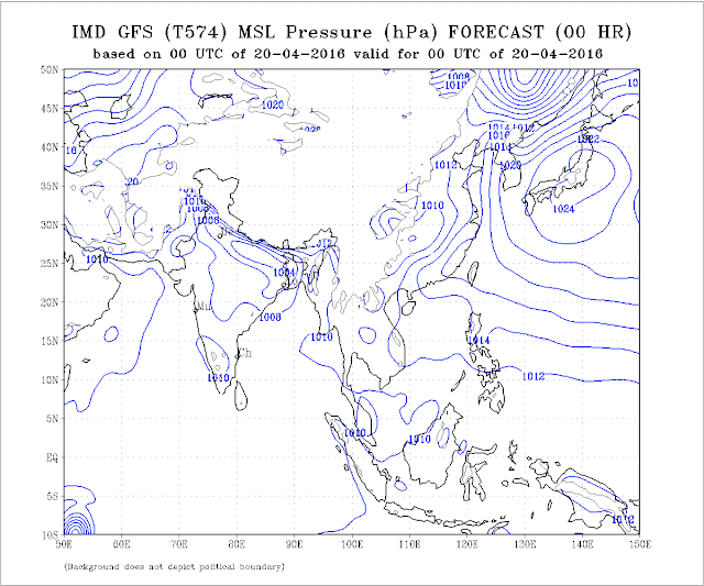
Last 2 days, the lowest pressure, in the Thar Desert region was at 1000/1002 mb. (though 2011/2014 was 1006 mb, 2010/2012 was at 1002 mb this time. 2015 it was at 1002 mb).

Overall, even the 1002 mb Low is within the NW region of the India/Pakistan region.
Currently on 20th, the core pressure has increased to 1004 mb.


 Lows over MP, Central India,  should become less conspicuous because of the strengthening of the seasonal low over NW india.


As mentioned, it normally should reach a low nadir of 994 mb in June in the Thar Desert, and with 1008mb in the South Arabian Sea, a perfect gradient is created to attract the south -west winds towards the coast.


Seasonal Low should speed up now with extreme heat in the region.

Thunderstorm activity in Southern Tibet is also seen to be picking up. 


The Line of Wind Discontinuity should normally stabilise around Central India perpendicular down into the Southern Peninsula by mid April. 


This enhances the speed of the Seasonal Low formation. Normally is required to start taking shape for the monsoon by the second week of April.


Currently,   LWD through Central Maharashtra down to Tamil Nadu is forming due to UAC is established over Marathwada.

In reality, this LWD remains till June, in variable phases, and finally merges with the Monsoon trough (axis)/ITCZ  when the ICTZ moves towards the Sub Continent.

Indicator: +ve


2. ENSO: During January-mid March 2015, near to-above average SSTs were observed in the eastern Pacific. At the sea surface, temperatures have cooled by over 1 °C since their peak, but remain warmer than average and still at El Niño levels. 


March values show the NINO3 region in the eastern Pacific cooled by 0.1 °C and the NINO3.4 region cooled by 0.4 °C over the past month.


     to 20/3/2016     to 27/3/2016       to 3/4/2016         to 10/4/2016

NINO3 +1.5 °C     +1.4 °C                        +1.5 °C               +1.3 °C
NINO3.4 +1.4 °C     +1.4 °C                        +1.2 °C               +1.2 °C
NINO4 +1.2 °C     +1.2 °C                       +1.0 °C               +0.8 °C
NINO 3.4 is the predominant Region to see ..For our region.

The SOI is at a lowering level at but remains within values indicative of neutral ENSO conditions. The latest 30-day SOI value is -7. This is the threshold of El Nino levels, below -7 is considered El Nino.


The most recent ONI value

(January– March 2016) is 2.0c.

El Niño: characterized by a positive ONI greater than or equal to +0.5ºC.
La Niña: characterized by a negative ONI less than or equal to -0.5ºC.
By historical standards, to be classified as a full-fledged El Niño or La Niña episode, these thresholds must be exceeded for a period of at least 5 consecutive overlapping
3-month seasons.

Weak El Niño conditions are present.

3. Cross Equatorial Winds:

Let me explain, that the winds on crossing the equator break into 2 branches. 1) gushing into the Arabian Sea, and 2) moving into the Bay of Bengal. 

Last week, the Monsoon winds, which originate from the Southern Indian Ocean as SE winds, and cross the equator to become South-West, were weak. 

In the Western sector, now, we see the dis-organisation of the Southern Hemisphere SE winds, with Cyclone Fantala and a Low South of Sri Lanka. The regular SE flow towards East Africa is disturbed.Tropical cyclone Fantala, which reached category 5 intensity, is the strongest cyclone on record to form this late in the tropical cyclone season in the southwest Indian Ocean.

In the Western Sector, the Arabian Sea branch is still struggling to get organised. Here, sufficient wind speed off the Kenyan coast has yet to form the SE flow required. But should re-organise fast. The Northwards movement of the ITCZ will surely hasten and strengthen the winds.

But, it is a temporary upset, and things will get back to the normal cross equatorial flows within a few days. 


In the eastern sector,  and the Westerly flow in the Bay sector is also gone haywire. 

And that is exactly where the start should be for the SWM to arrive at the Andamans. Upper winds at 100-400 hpa are vigorously aiding the lower winds to attain the required strength.
We prefer  the Bay Branch to be better organised, as the S W Monsoon is expected there in 22-25 days…

Mascarene high pressure zones in the South Indian Ocean. Main High reading now 1023mb, and 2 more Highs (in the forming) have been observed, one at 1023mb and another at 1017 mb. between Madagascar and Australia.

The "Power House" of the Monsoon winds is slightly behind schedule, for this time of the season. Last year in MW2 we had highs of 1031 mb already formed. A bit this year...(Cyclone effect).

Indicator: -ve


4. But the pre Monsoon Low in the Bay is still elusive. 

As discussed, we should normally see a low sometime after the 15th. of April. The high pressure region in the Bay, at sea level, no longer prevails.

I do not see much happening soon, as the region does not have the support of a strong MJO. An strong MJO would hasten the favourable formations and lows, with enhanced precipitation. We  see the MJO wave gradually approaching till 28th April. Might bring some rains in the Bay. But will a sort of "false alarm"...As the MJO, it Seems will remain weak another 10 days thence.
Another factor, which helps the winds gain strength, and bring more moisture into the Indian landmass, is the sea temperatures on both sides of the Peninsula. Optimum (warm) temperatures will hasten and create more clouds, and help in faster forming of the lows from the Bay. 


Indicator: -ve


5. To bring the existing SE winds above the equator, the ITCZ should move northwards. Around 1st. of May, this should cross the equator. The ITCZ should now come back to its Northward position, as the effective "Lows" created by the Rossby Wave are reducing. 

ITCZ around 5S currently.

Indicator: Normal


So, overall, we can summarise as:

Parameter:    1): +ve    2): El Nino (Weak).  3) -ve   4) -ve   5) Normal.

Two parameters are -ve as of today ( weak El Nino Taken as negative as yet). In today's situation, Monsoon arrival in Kerala could be a bit delayed in Kerala and the Bay Islands, and the NE states. 


We will put up the estimated date of arrival in the MW-3.


But, situations can change fast, and by the time we discuss the next MW, some factors can suddenly become +ve or -ve. So, MW discusses and follows the developments as they emerge, and discuss the parameters as is where is. 


No model can commit  today when the Monsoon can arrive. 

Quantum of rain forecasting in April for June right through September is an impossible task. Things get clearer by last week of April. Vagaries' (in MW) normally remains true to estimates around early May. 

Next MW up on 2nd May with Dates of Monsoon Arrival.


Tuesday, April 19, 2016

Precarious Water position in Interior Maharahtra:

Marathwada water storage is precarious, with only 3% Storage Level ( In all Dams and Resrvoirs) available today. 8 out of 11 dams are at 0 level !
Comparatively, the levels were at 11% in 2015 and 30% in 2014. 

Nasik Region is also in trouble, with the reservoirs at 16% full this year. In 2015 they were 34% filled on date and 39% in 2014.
In the Pune region, the Storage Dams and reservoirs are 21% filled this year. Last year on date, the levels were at 41% and 36% in 2014.
Konkan is the only region which shows better storage this year at 46% as compared to 45% last year.

Overall, considering all the dams and resrvoirs of Maharshtra, the levels are 19% full this year. In 2015 the reservoirs were 32% and 38% in 2014.

Around  Mumbai: The 7 Lakes and dams supplying water to Mumbai (Modaksagar, Vihar, Tansa, Tulshi, Bhatsa, Upper and Middle Vaitarna) have a combined storage 0f 706 Mcum, 48% of Storage, (as on 15th April).source wrd. 
Normally, as Bhatsa and Vaitarna  water is diverted to irrigation and Thane to some extent, we take reduction in the 706 Mcum measure available for Mumbai. 

Water Supply Postion of Thane: The Lakes from which supply is shared to Thane are Bhatsa, Vaitarna and Barvi. They are 41%, 49% and 30 % full respectively.

Navi Mumbai supply is from Barvi (30%), Morbe (24%), Hetawane (50%) and 
Panvel gets from Dehrang 13%.
Barvi water goes to other regions as well.

Saturday, April 16, 2016

Saturday 16th April 2016
TOP 10 hot centres of India....First 46 c max temp recorded today for India summer 2016 ..... Bankura breaks its all time record for April which was 45.2c recorded on 15th April 1973


1 Bankura (India) 46.0 °C
2 Sundargarh (India) 46.0 °C
3 Khajuraho (India) 45.6 °C
4 Nowgong (India) 45.5 °C
5 Banda (India) 45.4 °C
6 Jamshedpur (India) 45.1 °C
7 Bhawanipatna (India) 45.0 °C
8 Damoh (India) 45.0 °C
9 Ramgundam (India) 45.0 °C
10 Nizamabad (India) 44.9 °C


Sent by Patel Ankit 

Mahableshwar marginalised a bit lower on Saturday, topping 34c. 
I feel, the minimum in Mahableshwar could be near the highest recorded...it was 22.6c. I dont remember seeing this minimum in this station .

Friday, April 15, 2016

Mahableshwar  .. Warmer than Mumbai!! 
Mahableshwar, a Hill station in Maharashtra , at a height of 4500 feet ASL, is also caught in the grip of the National Heat wave. The station recorded  36.4c (5c above normal) on Friday.
Of course, the hottest April ever is not touched, which was a hot 37.6c on 21st April 1976. The highest ever record for Mahableshwar is 38.2c on 24th March 2003.
Pune soared to 40.8c and Aurangabad was hot at 41.2c on Friday.

The heat now creep into the heat prone region, Vidharbh. 
Wardha was 45c on Friday, Chandrapur 44.6c and Akola 44.4c. 
Nizamabad records a sizzling 44.9c !
Titlagarh (Odisha) recorded 45.7c !

Maharashtra Map...Many Places above 43c...(click and enlarge for better view) (Map from Rohit)


Kolkata DumDum has risen to 41.2c on Friday. 
Bangalore was at 37.5c. and Bangalore (HAL) was at 36.7c.

Max informs us of New Record for Chintamani town (Karnataka). The town recorded 38c on Thursday, beating its previous high of 37.6c recorded on 12th April 2010.

Heat has started in full strength in Pakistan also. On Thursday, Dadu was 46c and 45c at Pad idan, Jacobabad and Sh.Benazirabad.

On Friday, Pad idan and Sibbi recorded 43.5c and Jacobabad 43c. 

Wednesday, April 13, 2016

Saturday, April 09, 2016

Monsoon Watch - 1... 2016
These reports are my personal views, study and observations. Estimates and forecasts are also my own calculations and views, and may/may not tally with any other estimates. This may not be used for commercial purposes. The author is not responsible for any commercial loss from this article, or this series of articles.

The Monsoon developments, as they unfold, will be analysed and discussed and explained in Vagaries. 


The South West Monsoon is just about 35 days away from its normal date of arrival from the shores of India ! Yes ! its just 35 days from the First touch of shores...Southern most point of India on the South Andaman Islands, Indira Point, where the normal arrival date is 15th May.

And its about time we start the follow up of its progress and monitor its developments. 

The Sub-Continent is eagerly awaiting for its share of 2016 monsoon rains !


This annual series is a follow up and chasing of the South-West Monsoon. 


Every article in this series explains the synoptic situation as it actually is, and based on the day's position, the date and quantum of rains as on THIS SITUATION.


It is very important to firstly estimate the date of arrival of the S W Monsoon, as year to year, variations in dates of onset of the monsoon can occur and there have been several occasions in the past when the monsoon arrived over certain parts of the country about a fortnight earlier or later than the normal dates. The SWM has the  weatherman tearing at his hair for the exact date or time, extent and progress. This is never 100 per cent sure though various weather models are used to calculate this event.

Initially, in the firsr few articles, of this series will be chasing and closely following up the actual developments of the monsoon parameters, and analysing its progress regionally for calculating and estimating the arrival date. 
We are not yet contemplating the quantum of rains or the monsoon strength as yet. 

There are 2 parts to this article:

A)-This is the Ideal Conditions  During SWM Onset in Early June.

B)below indicates the actual situation of the parameters situation today (9th April).

A)

Very very briefly, let  us first understand, that the "power house" of our SWM is actually based far away in the southern Hemisphere. The main "generating factory" is the Mascarene Highs, between the Madagascar coast and Australia. The SWM is born down South, 4000 kms from the Indian Mainland !

The proper formation of these high regions,(1032/1034 mb at least) will boost and create proper SE winds to lash the East African Coast near the Equator, and then turn perpendicular towards SW in the Northern Hemisphere. 


And the formation of the "Tibetan High" is another factor. An anti-cyclone in the upper atmosphere over the Tibetan Plateau. During the formation stages, there will be thunderstorm activity in the SE parts of Tibet during the months of April and May.


To generate a powerful SW wind, the cross equatorial flow must be strong and gusty. SW winds (ultimately upto 600 mb levels) then are capable of riding on the warmer Arabian Sea waters (Arabian Sea Branch of SWM) and bring cloud masses towards the West Coast of India. In the Bay, similar SW winds are generated (Bay branch of SWM), but from SE winds below the equator, just below Sri Lanka.


And to attract the SW winds, again, we need a good proper "seasonal low" to develop in the Sub-Continent. This seasonal low, normally should start forming around Barmer, Rajasthan, by mid April, and at its peak stretch upto Arabia. Seasonal low at its peak, in June, should normally be around 994 mb, and the ridge around Kerala should be 1008/1010 mb. This enables a good gradient to pull the SWM Northwards and inland.


B)-In this initial stage, we will observe the basic root and foundation, the initial 4 parameters only, and the initial seed of the monsoon. From these parameters, later a few more develop.

1. Cross Equatorial Winds from Southern Hemisphere.
2. Seasonal Low over India/Pakistan.
3. ENSO Status.
4. Pre Monsoon Low in the Bay.

Position as on 9th April:

1. Cross Equatorial Winds:
The Mascarene Highs are the main "Power House" of the South -West Monsoons. This generates the South -East winds, which after gaining strength, cross the equator and become south west. For a proper High to form in the South Indian Ocean, the cyclone season (Low pressures) should completely die down from that region.

As on date today, the Mascarene Highs is yet to form in the required region. Just a small High at 1029 mb. South West off Australia. Four "weak" Lows are tracking in the region. We have to wait for these "lows" to dissipate.

No Tropical Storms around, so no delaying the proper arrangements for a series of Highs. ( Cyclone Zena not likely to disturb the "set up"). 


But things are un-organised  below the Equator.( Wind Chart Below)

Cross Equatorial Winds should start forming, and taking shape from mid -April, especially in the South Indian ocean region. 
Initial forming of SE winds off the East African Coast has started from below the equator. Weak SW flow below Sri Lanka (in the Southern Hemisphere) can be see, though a bit dis-organised.


ITCZ:This Seasonal trough passes from the South  Arabian Sea to Andaman sea after the withdrawal of SWM in Oct. Shifts further south in Dec. Moves North during SWM
Now near the equator.

Today, the winds  North of the Equator revolve round a High in the Arabian Sea (normal), and are Westerly South of the Arabian Sea. 

As the Monsoon strikes the Andaman Sea by mid May, developing wind currents ( Westerly) are required to be observed initially near the Eastern side of the Southern Indian Ocean, and this is weakly forming as of today, Southerly flows are striking Sumatra. Winds are from the East in the Southern Andaman Sea.
Indicator: Normal

2. Seasonal Low: Now, this year, the heating in the sub continent has started from March end , with  Heat Waves in Gujarat, Central India and parts of NW India.. The above normal heating in many parts continues in April.  

On an average, March has registered normal temperature (average day and night), and, with absolutely normal rainfall...29.8 mms received against the normal required of 29.8 mms.. These are a points in the formation, or a quicker formation of one of the important pre monsoon weather requirement, the seasonal low.
Add caption

In June,the seasonal low, which stretches to Arabia from India, normally starts forming in the Barmer and adjoining regions in the second week of April. 
Today, the MSL is around 1008 mb in the North Rajasthan/Sindh region. There is a isobar of 1008/1010 mb covering almost the entire Indian region. In the "core seed" area, it 1008 mb. (The ultimate low in the core, in June when ready, should be 994mb.). This progress is bit tardy. 
Add caption

The current Line of Wind Discontinuity should stabilise around Central India perpendicular down into the Southern Peninsula. This enhances the speed of the Seasonal Low formation. Normally is required to start taking shape for the monsoon by the second week of April. 
Indicator: +ve

3. ENSO is on way to a Neutral Stage. 

This year also, like last year, we also base our observations on the Multivariate ENSO Index (MEI).  An attempt is made to monitor ENSO by basing the Multivariate ENSO Index (MEI) on the six main observed variables over the tropical Pacific. 

These six variables are: sea-level pressure (P), zonal (U) and meridional (V) components of the surface wind, sea surface temperature (S), surface air temperature (A), and total cloudiness fraction of the sky (C). (Negative values of the MEI represent the cold ENSO phase, a.k.a.La Niña, while positive MEI values represent the warm ENSO phase (El Niño).The MEI is computed separately for each of twelve sliding bi-monthly seasons (Dec/Jan, Jan/Feb,..., Nov/Dec). 


The updated (February-March) MEI has dropped from 2.202 (in December-January) to 1.96, for a slightly decreased ranking, now moving towards neutral stage. 


SOI is falling, and is now at - 7.6 ...Now "coming out of the the EL Nino range"..It was -21 15 days ago.


The Oceanic Nino Index (ONI) is based on SST departures from average in the Niño 3.4 region, and is a principal measure for monitoring, assessing, and predicting ENSO. The last 3 overlapping seasons show towards establishment of a neutral event. 

ONI latest is 2.0... Just marginal, could get lower in the coming months...But at this stage, it cannot be surely mentioned, that an neutral stage could fully develop by June, the onset time of our South West Monsoon.( 0.5 - -0.5 is neutral. Above 0.5 is El Nino, and below -0.5 is La Nina).

Indicator: Heading towards Neutral.


4. Another pre monsoon seasonal normal requirement is the creation of a low in the Bay by the second week of April. This is necessary to trigger off the flow and formation of lows from the bay.

Progress this year is bad, as the Bay shows no signs today. No forecast of any low as of now. (in 2009,a low formed by the 12th. of April, and later it intensified into cyclone "Bijli", 2010 had no low till 3rd week of april).
Today, we have East winds. The required SW winds may not yet form at least for the next 3/4 days, as a High is likely to form later this week off Odisha Coast.

Indicator: -ve


Summary for arrival Date: Parameter 1). Normal.  Parameter 2). +ve,  Parameter 3). Neutral Parameter 4). -ve.

Summary: Tilted towards the normal, as of 10th April. Parameters analysed as of now show normal progress for Monsoon Advance on time.


New Readers, please note, These initial Parameters are normally (every year) considered in MW Series to gauge and estimate the arrival date of SWM, not strength. Time of arrival normally indicated in MW-3, and strength after 27th April. There are more parameters are to be considered, as and when they are developed and to be taken into consideration.


MW-2 on 20th. April.


While IMD still defers its forecast, IMD should have taken up this job in right earnest much earlier. Vagaries had mentioned this earlier here.. 


INDIA .. TEMP on 9 APRIL 2016

Before the monsoon  .. India is warming up ..


Monsoon Watch -1 will be published late on Saturday (today) night...a day ahead of announced date !! Be sure to analyse the progress with us ..

Thursday, April 07, 2016

Vagaries' Annual "Monsoon Watch" Series will be starting as Usual...Monsoon Watch -1 will be published around the normal date..10th April.


Monday, April 04, 2016

Vagaries' Annual "Monsoon Watch" Series will be starting as Usual...Monsoon Watch -1 will be published around the normal date..10th April

Heat Wave in North West/North and Central India...Max Temperatures 3rd April 2016

Day Temperatures will drop by 2/3c in North West and North India Including Delhi NCR from 5th April. 
Vidharbh and adjoining Southern MP will remain hot.


ELECTRIFIED - 30TH MARCH 2016 , Kolkata Lightning Storm

Saturday, April 02, 2016

MUMBAI SCZ .. A comparative analysis

Mumbai: Sunday and Monday will be partly cloudy. Windy from NW in the evenings...Day around 32/33c and nights around 24c.

Pune: Likely to remain around 40c next 2 days. Dropping temperatures at night will push the minimum to 19c.

Mumbai SCZ was warmer last year , compared to 3 years back 


APR 2015 - MAR 2016 : (Chart 1)
Avg. max : 32.9 c  , Avg. min : 22.7 c  .. Rains : 186 cms

AUG 2012 - JUL 2013 : (Chart 2)
Avg. max : 32.1 c  , Avg. min : 21.6.. Rains : 311 cms 

--------------------------------------------------------------------------------------------------------------------------------------
Click on the charts below for monthly comparison : 

Max / min temp in c ..  Rains in cms 

Chart 1 .. 

  ---------------------------------------------------------------------------------------------------------------------------------
 Chart 2 .. 


Forecasted East rough  Let's look into the 3rd week of March ( 17th - 21st). Mumbai : Hot weather likely for Mumbai region this week, ty...