Saturday, December 31, 2011

Pre New Year and New Years Day Forecast for Mumbai/Pune/Nagpur and Delhi on Mumbai Page:

New Year Eve and New Year Forecast:
Click here for Larger Image

Friday, December 30, 2011


Position @1.30 pm IST Friday. System pressures weakens to 993 mb and surface winds at 70 kmph. System moving west, slightly South. Heavy rains expected at Salem with gusty winds till tonite.

x------------------------x---------------------------------x---------------------------x-------x

Cyclone "Thane " crosses land at 4.30 am on Friday at exacly 11.8 N and 79.7E, that is at Puducherry. While crossing, it sustained core pressure at 983 mb, which weakened rapidly on hitting land.
Currently at 8.30 am, centre of system 55 kms west of Cuddalore.

Expected west movement with weakening. Overcast in Bangalore with cool Friday and intermittent rains.


Thursday, December 29, 2011

Reviewed at 10.pm IST, "Thane" is about 100 kms East of Puducherry. Notching up slightly, Pressure at 986 mb, the surface winds are 125 kmph, both parameters strengthening in the last 2 hrs.

Tracking slightly Northwards, 12.3N now), at about 10 kms per hour (currently), it can be assumed to cross the coast South of Chennai by early Friday Morning.

Chennai is facing gusty winds (NE) since 8.30 pm, and gusts have topped 56 kmph.
Cuddalore is experiencing moderate to heavy rains, and is a cool 23c at 9 pm. Wind s are at 30-35 kmph, with gust possibly of 60 kmph.

x-------------x-----------------------x---------------------x----------------x---x

Currently at 8.00 pm IST, "Thane "is 110 kms East of Puducherry, and has commenced its weakening phase. It is now 989 mb and surface maximum winds have dropped to 110 kmph. This weakening was expected from tonite (See previous post).
Rainfall in Chennai ( as per Kea Station) till 8.30 pm 24 mms.

Next Update at 10.0 pm IST.
click here for larger view
“Thane” : precariously close to coastline South of Chennai near Puducherry.
Just about 175 kms away from the coastline, at 81E, the strength has marginally weakened to 984 mb, not much to physically affect the strength, as winds are maintained at 14o kmph.

Map shows the latest position at 12Z 29th Thursday.

Expect heaviest rains in Chennai from around 6 pm on Thursday evening, and increasing rainfall along the coast.
Winds will be gale force and destructive along the T.N. coast.

Centre expected to cross late tonite just South of Chennai.
Click here for better view
Report of "Thane" at 2.30 pm IST Thursday:

System has moved NW, and lies 250 kms e/s/east of Chennai.Superimposed latest position on yesterday's Map above.

Expect more rains in Chennai as the storm moves NW, forecasted earlier by Vagaries.
Currently at 2 pm (IST) Chennai is a pleasant 22c and overcast with light to medium rains. Winds have notched up to 30 kmph by afternoon.
Very heavy rains and winds expected in Puducherry as the SW segment of the cyclone approaches the region.


Report as on 10 am (IST) Thursday:
"Thane" moves West, draws closer to Chennai, being just 300 kms ESE of the city. (12N and 83E).
Strength maintained at 980 mb, and core surface winds roaring at 130 kmph.
Chennai receiving persistant drizzle since last night. Rain intensity to increase from mid day, with thunder. Wind speed likely to touch 40-50 kmph today.

But, the system likely to start weakening from tonite.

Next update at 12 noon.

Wednesday, December 28, 2011

Click here for better view

"Thane" report as on 9.00 pm IST, Wednesday:

"Thane" deepening astoundingly, and is a very severe cyclonic storm (IMD terminology) with a core pressure of 980 mb and surface winds roaring at 120 kmph, gusting to 140 kmph !Cat. 1 as per international standards.

Now, tonite, in the next 12 hrs, there will be further intensification, with the pressure dropping further and winds raging to 140 kmph by tomorrow.
I would put up a special alert for the entire coast from Puducherry upto
Coastal A.P.

click here for larger view for Wind Field around storm


Very intense convection resultant clouds are observed west of the storm right upto the centre. Cloud tops are very high and temperatures are at -86c.
The pressure started droping from mid day today, Wednesday, and bottomed to 980 mb by 8.30 pm IST.

Chennai alert for high winds and gales from tonite.Cloudiness starts increasing rapidly, and coastal waves will be lashing at 22 feet.

x--------------------------x------------------------x--------------------x---------x

"Thane" deepens to 990 mb with gusty winds at 110 kmph.Currently (5 pm) at 500 kms west of Chennai.
Gusty winds at 30-40 kmph from a Northerly direction to hit Chennai from tonite. Heavy clouding and wind speed gradually on the increase from tonite..


Detailed traching and map will be up tonite...with latest at 19.30 pm


Report of 12.30 pm (IST) Wednesday.
As the ridge deepens, "Thane" moves due west. Moved marginally west in last 6 hrs, and is 550 kms due west of Chennai. Convection increases in the SW quadrant. Clouds at phenomenal height, with top at -85c ! Pressure at 992, but winds raging at 100 kmph. Seas getting rough.

Could strike by Friday, slightly North of Chennai, possibly at current strength.


Report of Wednesday Morning: Status Quo ! Same strength, same speed and moved just 1 degree due west.More around Noon.


Click here for better viewing

Not much change in the last 6 hrs ending mid night (IST) 27th . No change in track forecast . Hence reproduced on earlier map. Position "B" is the current location , as on mid night.

Tuesday, December 27, 2011

Latest on Tuesday afternoon shows the cyclone "Thane" taking a slight NW curve.We notice a ridge line having formed to the North, and Vagaries expects the ridge to deepen, enabling the cyclone to take a more Westwards curve.

At 12.4N AND 86.5E, the centre lies 700 kms ESE of Chennai.Surface wind speed is 40 knts, 75 kmh, and core pressure at 992 mb.Almost constant.Lately, convection has increased, and cloud top temperature (lowest) is -77c.

Mumbai S'Cruz registered a low of 11.4c on Tuesday morning.Nasik was 5.4c and Pune saw 7.6c.
Lowest in the plains of India was -1.6c at Amritsar.

Next update tonite @ 10 pm.
Tuesday Morning Update on "Thane"

BB-12 now sshows a distinct feature,a spiral, indicating strong core winds, already recording upto 50 knts, or 90 kmph, and core pressure at 992 mb.See an extreme close up of the centre above.

Named "Thane", it is set to intensify into a cat. 1 or maybe 2 storm soon. It can be said so, as it is almost stationary, and constantly picking up moisture and energy from the 27c warm waters. In fact, its convective cloud top temperatures have now scaled , or bottomed, -90c !
But, a defiant NE "cold" flow, will resist its intensification to some extent. It may even stop at a certain stage deepening after 24 hrs.

The much anticipated ridge axis along the 12N line has formed, forcing "Thane" to slowly track NW now, and,it seems to be heading towards Chennai. The city has to be alerted for a severe cyclonic storm !Rough seas will be created, with 14-16 feet waves lashing the North T.N. coastline.This is a fore warning, as today, most of the high winds are to the N and S of the cyclone, not to the West.See image.
Next update 6 hrs hence at 3 pm IST

Monday, December 26, 2011

Mumbai and Pune Weather Forecast updated ..see Mumbai Page.

sset: I explained in vagaries that the ridge will form next 12 hrs and steer the system westwards. I think it will hit coast south of or very near Chennai.

Viravanalluran and Pradeep: The system will hold strength,till it strikes the coast. after that will dissipate fast as it moves westwards.
That is what I forecast and estimate as on the current scenario.

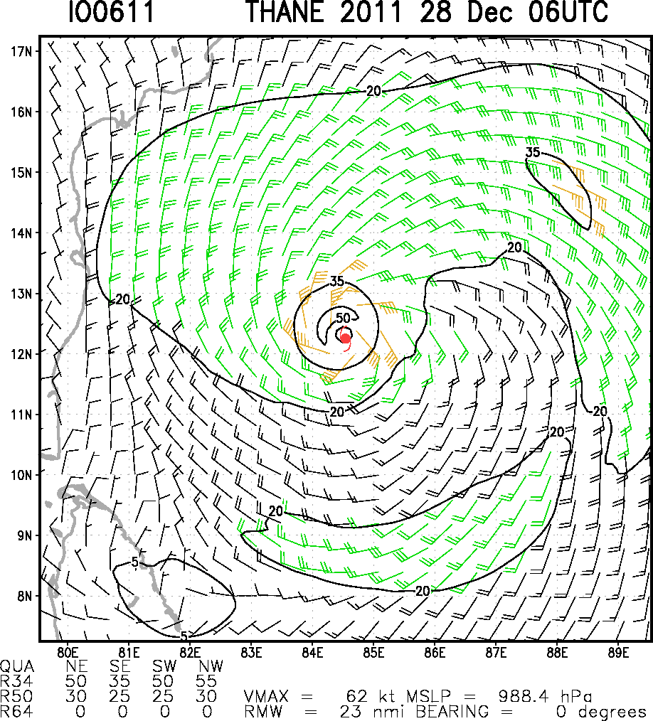
click here for better view of actual track
BB-12 Report:

System pressure plummets to 994 mb in the last 6 hrs ! So, it reaches the deep depression status ! Winds, currently at 40 knts are expected to strengthen soon, and cover the outer periphery too.Expected to become a cyclone on further deepening within 6-12 hrs.
Now,at 7.30 pm, located at 11.7N and 87E, it seems the system continues to move North. Superb convection and build up has resulted in the highest cloud top temperatures reaching a phenomenal -78c !

We can expect a ridge axis to quickly develop above the 12N line, which will make the system turn westwards.Vagaries expects the cyclone to cross the T.N. coast south of Chennai by 28th late night.


Click here for larger viewvery severe weather with heavy rains could be expected in Chennai from 27th. Bangalore may follow the next day with heavy rains.

Sunday, December 25, 2011


BB-12 Report as ot 10.30 pm IST Sunday:


Since our last report, the system has tracked due North/NE, and, if it may be said, has achieved and reached the Sunday position estimated by Vagaries in the map published on the 23rd, shown as position "A" in the original forecast map reproduced again above. Only variation is the estimated pressure by vagaries was 1000 mb and actual is at 1003 mb.

Now,at 10N and 88E,it is expected to track to position "B" almost as per our schedule.Pressure is 1003 mb and winds at 25 knts, BB-12 should deepen by tomorrow to 1000 mb and become a depression.

Vagaries had put up a temperature forecast map on the 20th of December, for a 22nd - 26th temperature forecast. Certain temperatures forecasted like Kathmandu,Srinagar, Mumbai and Chandigarh are almost as per estimate, while a few vary by a degree here and there.
Shall put up a forecast map for the 27th-1st Jan period tomorrow night. Should give a rough idea of the New Year Eve forecasted weather.


Cold but snowless Christmas for the North. Leh at -26c and Gulmarg at -10c were among the lows in the state.
Lowest in the plains on Christmas morning (as reported) was -1.4c at Churu (Rajasthan). Amritsar was -0.6c and Hissar at 0c on Christmas morning.
Nalliya in Gujarat was the lowest in the state at 3.2c.
In Mah, Ahmadnagar was 6c and Nasik at 7c.

Across the border, Islamabad and Sibbi plummet to -2c and Karachi is steady at 8c.


 A Merry Christmas and Season's Greetings to all the Vagaries' Readers and Followers ! 

Cold Christmas Morning in NW India !
Leh at -16c, Srinagar at -5c, Churu repeats at -1c on Sunday morning, whilst Delhi dips to a low of 2.9c on Christmas morning ! More later as details pour in .

BB-12 moved ENE, and was stationed at 7.3N and 87E this morning. NE movement may be temporary, and could be due to the unexpected arriaval of a W.D. in the Northern regions. Strength almost constant at 1002 mb and winds at 25 knts. Track could possibly turn to our predicted course, only the W.D. has caused a delay of 24 hrs in the time schedule framed earlier.
Next update at 3 pm IST.


Saturday, December 24, 2011

Vagaries has numbered the low in sequence as BB-12. On Saturday morning, At a core pressure of 1002 mb, the system has moved NW and is 350 kms East of Colombo. As per vagaries forecast map, BB-12 will strengthen and move NW as shown, as it is embedded in the ITCZ.
Major clouding is in the North of the system due to the NEM moisture flow.
A W.D. has moved into Kashmir and adjoining North Pakistan regions today.


Friday, December 23, 2011


A low formed in the Bay labelled 92B has moved NW, and is east Sri Lanka at 6.6N and 85E.
At 1004 mb pressure as on Friday night, it is having winds at core of 15-20 knts.

The Northern segment of the system is enriched with good clouding due to the moistured laden NE monsoon winds hitting the system.With SST at 27c, it may just about hold on.

Tracking path expected is NW, and deepening to level 1000 mb initially by Sunday, and then to depression level of 998 mb by Monday,system can cross the T.N.coast by Monday. Very heavy rains expected as a result in Eastern parts of the Island and Southern T.N.from Saturday night.

Progressive increase in preciipitation on Sunday on entire T.N. coastline and Southern interior T.N.Rainfall in excess of 100 mms possible in some places along T.N. coast on Sunday/Monday.
Upto 40-50 mms of rain possible in Chennai on Monday and Tuesday.
Gusty winds of 35 kmph likely along South T.N. Coast.

A strong upper air (500 hpa level) Sw wind has brought alto-cumulus clouding across the stretch from South Konkan thru Vidarbha and into M.P.on Friday. This should be temporary and vanish by Sunday, but bring about a rise in night temperatures in Vidarbha.

A mild W.D. is moving into the Northern regions of the sub-continent.

Thursday, December 22, 2011

Parts of Sindh in Pakistan are reeling under a severe cold wave. 
As per the Pakistan Met site, Nokkundi in the Sindh recorded a minimum of -5.3c ! The confusion is that some other international sites show Nokkundi minimum as 0c on the same morning (Thursday).Yet to verify the correct temperature.
And Sibbi was -1c on Thursday morning. 
Karachi dipped to 7c. We had expected the port city to drop to 9c (between 22nd and 26th, as per map put up yesterday). Expected to maintain trend of 8/9c till 25th. 


Kathmandu was forecasted to drop to 2c, and the reading today morning was 1.5c.


In India. Bhatinda was the lowest in the plains at 1.2c. In the hills, Leh was at a seasonal low of -16c on Thursday.
Cold conditions are expected to spread Eastwards into India, The NW regions initially, from Friday. And the NW winds (as per our yesterday's map) will gain from Friday.


Mumbai too, is expeceted to follow the trend. Our estimate of 16c in the 22-26 period is very much on target.
Pune is heading towards 9c.
Nagpur was very low at 9c on Thursday. Likely to maintain the 8/9 level for the next 3/4 days.


Check Space News Update...

Tuesday, December 20, 2011

Our expected W.D, numbered D-2, brought moderate snowfall to Kashmir. Resorts of Gulmarg, Sonmarg and Pahalgam received around 1-2 cms of snow. Though not heavy, it was welcome.
Srinagar had freezing rain, but no snow was reported.
Also, as expected, the cold wave abets to some extent, and the lowest temperatures showed a marked rise.


As the system moves away, after the 22nd, we can expect NW winds to set in along the NW /Central and West Coast of India.


Click here for Larger Map


For the next 3/4 days (22-26th), the regions shown in the Vagaries map above would be in for cold windy days and a drop in the night temperatures. 


The plains of Pakistan, right down to the Coast, will be windy (NW), and nights are expected to drop till the 26th.
Karachi, which is currently at 13c, can fall back to 10c from the 23rd/24th.


We shall monitor the system approaching the Southern T.N. coast. 

Monday, December 19, 2011

Cold is holding its grip over the Northern region of the sub-continent.
The lowest in the Indian region was Adampur (Punjab) which saw a low of -0.4c on Monday, with Hissar in Haryana at 0c on Monday. Amritsar with 1c was another place with extremely low night temperature.
The days were cold in U.P. and adjoining regions on Monday. Varanasi at 14c in the day being 11c below normal, Allahabad having a high of 15c, which was 10c below normal. All places in the region were around 7-10c below normal in the day.

The persisting cold wave is attributed to the high pressure area (upper air) sitting over the area. With the NW winds starting after the W.D. passes, say by the 21st, we can expect the days in the North to become normal, and cold winds would sweep the NW and central regions.

Meanwhile the W.D, mentioned in Sunday's blog, is moving into the Kashmir region. Would expect Srinagar to receive its first snow on Tuesday.
Snowfall, heavy on the higher portions, is expected on the Jammu-Srinagar highway on Tuesday. Travelers are expected to be prepared for closures in parts.

Delhi will be partly cloudy next 2 days, with the night temperature going up marginally to 7c; with the days will be around 20c.

Mumbai: Tuesday and Wednesday: Partly cloudy with high cirrus clouds. Max in the day will be around 32c, and night temperature should be 18/19c.

Pune: Tuesday and Wednesday: Partly cloudy with thick cirrus clouds (high). Day will be around 31c and night will be 12c.

Surat will be clear, with the day /Night range between 31c and 19c. Expecting cooling after the 24th.

An Easterly wave (mentioned in Sunday's Blog) will bring some rains to the South T.N coast on Tuesday and Wednesday. As mentioned earlier, a pulse from the typhoon Washi hold on to a chance of a system coming towards the East coast around the 25th.

Sunday, December 18, 2011

A moderate cold wave has been sweeping the Northern regions of the sub-continent since 14th of December.
In the plains of India, we have seen a low of 1c at Churu on the 17th, and frequent lows of 2c at Amritsar, Karnaul, Agra and Hissar. Delhi has seen a low of 4.7c yesterday, and frequented 5c a couple of times.

In Kashmir, Leh plunged to -13c as its lowest this season, and Srinagar was at -4.3c as the minimum. In H.P, Keylong saw -6c on a couple of occasions. In the higher reaches, it was Shyok at -24c as the leader in the country.
 The cold penetrated thru Punjab, Chandigarh (at 5c) and into M.P. with Umeria and Gwalior seeing 4c, and Rajasthan. The nights  in Gujarat and Madhya Mah. (Western interior Mah) were below normal by 2c (See map above), but not severe. Nalliya in Kutch recorded 5c a few nights back, and Rajkot hovered around 10/11c. Nasik reached 9.6c, while Pune saw 10/11c on a few nights.
Due to dry conditions, and absence of rains, the entire southern peninsula was around 2c below normal.

The cold, even normal minimums, evades the coastal belt of Mah. and Gujarat. Mumbai S'Cruz has not gone below 16c, that too on one occasion and Colaba has reached only 21c on a single night. The reason is obvious. See on the * below.

Across the Western border in Pakistan too, it has been cold in the plains, with the capital Islamabad hitting below freezing, at -1c continuously on several nights.Lahore, Gujranwala and Faisalabad are at 3c.
In the Sindh region, Nokkundi has been bottoming 1c on a couple of occasions, and the interiors of the region are cold at around 2-4c, with Sibbi constantly at 2c.
The coastal city of Karachi plummeted to 10c, and has maintained this currently.

Kathmandu has been seeing colder nights, with lows touching 2.6c on a few occasions the capital is constantly steady at 3c since the last one week. As Neeraj points out, this year fog seems to be rare. It is just absent #. (His report put up interactive page for those interested).

#For the entire region, I would attribute this cold wave not to a W.D. but to a weather condition which i have explained in this blog earlier.
It is due to a stationary high pressure zone over the region. A constant high pressure area causes the skies to clear and a cold front encroaches the area. In reality, it is an aftermath of a W.D. Currently there is no precipitation.
* Hence, actually, there is no cold wind sweeping the regions from the North, like it happens after a W.D.When the cols wave is due to a direct W.D. effect, we have cold NW winds sweeping down and covering the entire region and the West coast.*

Now, we have a weakish W.D. coming by the 20th. Weak, because it is an upper air system. Being such, it should bring precipitation to the upper hilly regions of the sub continent, and some good snowfall in Kashmir from the 20th. But rains will be scanty in the plains of Punjab and Haryana.
That translates to an abetment of the current cold wave.

Mumbai, on the other hand will now see more civilized day temperatures. The days at S’Cruz have been constantly between 34-35c, almost since the beginning of this month. And obviously that is above the normal of what this city should expect.

From the 19th/20th onwards, I expect the day temperatures not to exceed the 31/32c mark. A gradual fall of around 3c, and that too in the day. Most welcome I am sure !

The nights in Mumbai would be around the current level till the 25th. Should hover around the 17c/18c mark at S”Cruz and around 21c at Colaba. From the 25th to the 31st, I expect the nights to drop. Not too much, but to around the 15c level, with an odd night at 14c, at S’Cruz, and to the 19c level, with an odd night at 18c for Colaba.

On the other hand, I think Pune should expect the nights to come back to the 13c/14c level, and drop again to 10c after the 25th of December.

For the South, an easterly wave is expected to bring in a spell of rain of the NEM. Around the 20th of December. Rains will concentrated in the extreme south of the peninsula. Would be heavier in Sri Lanka and southern T.N.
Another spell. Could be the ultimate, is pushing in to reach the T.N. shores by the 25th.

Saturday, December 17, 2011

Tuesday, December 13, 2011

Please Check Snippets (right of page) regularly from Today..Brief one Liners will be Put up when detailed Publishing not Required.


Cold Wave intensifies in Northern Pakistan plains, as Islamabad touches freezing point, 0c, on Tuesday morning. Whilst Sibbi, in Sindh, maintained its low at 2c, Karachi rose marginally to 15c. The lowest was at Nokkundi, 1.9c.

In India, the lowest in the plains was 3.7c at Hissar.
As estimated yesterday, the night temperatures will rise from Wednesday.

Cold Wave moves from North/Central India to Nepal. Kathmandu saw a low of 2.7c on Tuesday. Jumla in the higher reaches saw -5.7c.
For Nepal, the cold, like in India, will last for a couple of days.

Partly cloudy (High to medium level) weather likely on Wednesday and Thursday in Saurashtra, resulting in rise in temperatures from current level.

Mumbai and Pune will be partly cloudy, mostly high clouds, next two days. The nights will be around 19c in Mumbai and 15c for Pune on Wed/Thursday. But, days will be warm, around 33c and 31c in Mumbai and Pune.

Monday, December 12, 2011

A cold wave is sweeping thru Kutch, with Naliya recording 4.6c on Monday mornning.Kandla reached 9c and Rajkot was 10c all on Monday morning.

Across the border, a cold wave is prevailing in the Central and Northern regions of Pakistan, an aftermath of the recent W.D.
On Monday morning,Islamabad dropped to 2c, and in Sindh, Sibbi too was at a low of 2c. The lowets in the Sindh was 0.5c at Las Bella.
With Karachi and Hyderabad at 13c, I expect the nights to rise after Wednesday morning.

North India and Pakistan will see a rise of 2/3c from current temperatures from Wednesday.


A depression, 26 W is now in the western Pacific,east of Vietnam. At 1000 mb, and winds at 30 knts, system is set to move due west, and pass South of Vietnam by the 15th. fo December.
Should normally send a pulse into the Bay of Bengal.

A low pressure can form in the Bay by the 17th/18th, could develop into a depression and approach the T.N. coast around the 20th.This could bring about a final bout of good and meaningfull rainfall in T.N. May well be the final round before the NEM withdraws.
Hence, expecting rainfall in T.N. from the 20th/21st.Sri Lanka will get heavy rains during the period 18th Dec-23rd Dec.

Indications today show this rain persisting in T.N. and moving inland into the interiors of the state and S.I.Karnataka around 22/23 of December. This is a 10 day estimate, and could vary.

A low in the Western Arabian Sea will form by Tuesday, and initially remain stationary. Will move due west later after a couple of days.Only effect will be rainfall in the Lakshdweep Islands.

Mumbai and Pune Forecast:Not expecting a further fall in night temperatures for the next 3 nights.

Tuesday/Wednesday: Hazy and high clouds. Day will be around 32c and night will be 17c.

Thursday: clear with day temperature at 31c and night at 18c.

Pune will be clear, with day temperature at 31c and night at 12c on Tuesday/Wednesday.


U.K. Weather set to Worsen…More on Mark’Blog.

Strong winds, heavy rains to spread across UK tonight, Windy Wednesday for north but late week storm still looking strong and damaging

50-60MPH WINDS POSSIBLE ANYWHERE THROUGH TONIGHT AS FRONT SWEEPS THROUGH


*HEAVY RAIN MAY LEAD TO LOCALISED FLOODING A SERIOUS SURFACE SRAY ON ROADS

BIG FREEZE SET TO STRIKE AGAIN TEMPERATURES WILL PLUMMET TO MINUS 10C

Saturday, December 10, 2011

Please Check Snippets (right of page) regularly from Now..Brief one Liners will be Put up when detailed Publishing not Required.

astronomical scale picture sequences,….see space news page


Ending Phase:


Moon reappears after Total Eclipse

Courtesy Ashokbhai


Courtesy Ashokbhai.

Akshay Deoras
Severe Earth & Space Weather Forecaster,Astrophysics article writer.

Web-
www.akshaydeoras.blogspot.com

Vagaries will be putting up Live Pictures of the Eclipsed Moon at 7 pm, 8 pm, and 9 pm.(IST).

The pictures will be published "on the spot" live and will be sent to us by Akshay's AKG Centre from Nagpur.

Be sure to see this spectacular event live on Vagaries !

Friday, December 09, 2011

click here for larger view
Timings and Details of the Total Lunar Eclipse on Saturday, 10th December:

For India:
In the NE states,West Bengal,Sikkim,Bihar,Jharkhand and some parts of Chattisgarh, the moon rises before the P1 stage. So they can experience the entire phenomena starting with the shading of the moon. Places other than these, will see an eclipsed moon rising.

Moon enters the Umbra - 0615PM IST
Total Eclipse Begins - 0736PM IST

MAXIMUM - 0802PM IST
Total Eclipse Ends- 0827PM IST
Partial Eclipse ends - 0948PM IST
Penumbral Eclipse ends- 11PM IST

Moon Rise in Mumbai on Saturday is at 17h 57m IST.

The general timings for regions shown in the map above are -

P1 = 11:33:32 UT ….. (0503PM IST)….. Moon enters the penumbra

U1 = 12:45:42 UT …. (0615PM IST)….. Moon enters the umbra

U2 = 14:06:16 UT ….. (0736PM IST) … TOTAL ECLIPSE BEGINS

GREATEST ECLIPSE - 1432UT ( 0802PM IST)

U3 = 14:57:24 UT …. (0827PM IST)
U4 = 16:17:58 UT….. (0948PM IST) … MOON LEAVES UMBRA
P4 = 17:30:00 UT …. (11PM IST) … ECLIPSE ENDS
Details from Akshay's Blog.

More details about the concept and actual FAQs of a Lunar eclipse are explained and found on Akshay's Blog here.

Thursday, December 08, 2011


Severe Weather News from Mark’s Blog !!

Scotland Storm from Mark’s blog.

SCOTLAND ENDURED 170 MPH ATLANTIC STORM CAUSING WIDESPREAD DISRUPTION, DAMAGE

Police are warning against all travel in the central belt in an unprecedented move as winds of more than 160mph batter Scotland.

Strong gusts: An easyJet plane is blown around in the wind as it lands at Edinburgh airport this evening

Scotland storm blackout hitting thousands

The Met Office said winds at Cairngorm Summit had reached up to 165mph (264km/h).

RED WARNING!

HURRICANE-FORCE WINDS OF 75 TO 90 MPH TO BRING WIDESPREAD DISRUPTION ACROSS SCOTLAND ON THURSDAY

Not everyday do you see a red weather warning issued for the main population belt of Scotland!

'Red alert': Schools close as dangerous 100mph storms strike Scotland

Residents across parts of Scotland are being warned to take action as "dangerous" stormy weather with gusts of over 100mph hit the country.

An Atlantic storm is set to bring strong winds to the UK for Thursday and Friday, with gale force gusts affecting many areas.

x----------------------x-----------------------x--------------------x

The Botanical Gardens, Ooty on Wednesday, 7th Morning !

Severe frost has hit normal life, particularly during the early hours of morning in Ooty.
Among the places worst affected are the Government Botanical Garden, the Race Course and areas around the Ooty Lake.
With the mercury plummeting, the minimum temperature recorded at the observatory was 4c, while in the garden station it was 0c on Wednesday .

Tuesday, December 06, 2011

Total lunar Eclipse – December 10, 2011…see Space News Page

click here for larger view
Lowest in India on Tuesday, 6th December: Darbuk (Ladakh) : -16c. Leh was -8c, Gulmarg at -4c and Pahalgam at -1c.
Lowest in the plains of India :8c at Amritsar.

Hottest in Asia on Tuesday, 6th December: Dawei (Myanmar) and Ratnagiri (India) :35c. Along the west coast of India, Surat, Panjim and Mangalore were at 34c.

It seems the highest in Pakistan (Tuesday) was 34c at Mithi. 31c at Sibbi, Turbat and Karachi.

Kathmandu was still a bit warmer than normal at 20.5c, with the low at 8.6c.

Overall Departure map of India (on IMD site , seen here and here ) shows a major part of India in the "above normal" zone for the day and night temperatures.

Sunday, December 04, 2011

Forecasted Temperatures. Clear Weather with No Rain in the any of the cities below.

Forecast for Cities:

Mumbai S'Cruz:

Mon: Clear. 34c - 21c (Actual: 32 - 20)

Tue: Clear. 34c - 20c (33 - 20)

Wed: Clear. 33c - 19c.

Thu: Clear. 32c - 19c.


Pune:

Mon: Clear. 32c - 15c (Actual : 33 - 15)

Tue: Clear. 32c - 15c. (33 - 16)

Wed: Clear. 30c - 16c.

Thu: Clear. 30c - 16c


New Delhi:

Mon: Clear.shallow Fog. 25c - 13c (Actual: 30 - 11)

Tue: clear.Shallow Fog. 24c - 13c. (29 -15)

Wed: Clear. 25c -15c.

Thu: Clear. 26c - 16c.

An Easterly wave with embedded UAC is likely to bring rains along the T.N. coast by Wednesday. May be of moderate intensity.

No effective W.D. till Thursday, hence dry in the North.

Forecast post Thursday will be put up in a couple of days.

Topics From Mark’s Blog

Large portions of Scotland see or will see their first snowfall of season Sun/Mon

"I would be more concerned if the Arctic reservoir over Greenland and the Pole wasn't as strong as it is now.. It's turning increasingly bitter and all this must go somewhere, all we need is a flip in both NAO and NAO and that's got to happen sometime right"?

Friday, December 02, 2011

Mumbai/Pune weekend temperature forecast For Mumbai and Pune …see Mumbai Page

Worst Santa Ana windstorm to strike California in 10 years brings widespread damage and power loss. Be sure to check out details on Mark's Blog.

High Winds cause Massive Damage in Southern Cal..Los Angeles Times

Thursday, December 01, 2011

Its been a Warm November 2011 for the Sub-Continent:

Last week of November anomaly map shows extremely hot conditions in N.India and Central India, and most of Pakistan.

November Heat Wave In Himachal Pradesh:

The last few days of November, a winter month for this Himalayan State, has been Hot ! In fact, its a heat wave on ! With temperatures up to 10c (almost 18F) above normal in Simla, its literally Hot in the state.

Some Places in H.P. showing the max and min temperatures with departures as on 30th November.

Simla: 23 (+10) 6 (+1)

Dharamsala: 22 (+3) 6 (-2)

Keylong: 11 (+5) 4 (+4)

Manali: 18 3

Kalpa: 20 (+8) 7 (+8)

In fact, for the regions comprising H.P, almost throughout the month, its been hot,except for a few exceptional days during the tenure of W.D. This system had brought rains and snow initially in the month, in H.P.

Otherwise, the month has been absolutely dry, as seen from these November rainfall details for Himachal.

Place, November actual rain, Normal Total, % deficient.

HP State 7.7 45.1 -83%

SHIMLA 3.5 36.3 -90%

SOLAN 0.2 51.2 -99%

KINNAUR 1.4 34.4 -96%

BILASPUR 1.3 31.8 -96%

HAMIRPUR 3.3 40.9 -92%

Adverse NE and E winds replaced the normally required W winds. Moisture from the Arabian Sea brought in a lot of moisture into the regions, creating cloudiness and "trapped" heat.

Nepal too, has similar reasons for being hot. A similar state is prevelent in Nepal. Neeraj from Kathmandu writes -"What is the reason behind the temperature hovering in the 8C-22C range, in fact today it was 10c-22c here. Today is the last day of November, I guess the temperatures (esp the min temp) should be a little below this by now.Last year,it was 3.6C-23C on the same day and the year before that it was 6.3C- 22.6C".

Kathmandu too, has been warmer than usual for the month. I would work out the average for the month this year has been in the 23c - 10c range,while the normal is 23c - 7c.In fact Kathmandu too had received rains as a result of N2.

Mumbai/Pune November Weather and weekend Forecast… Chennai and B’Lore November Diagrams ..See Mumbai Page

Forecasted East rough  Let's look into the 3rd week of March ( 17th - 21st). Mumbai : Hot weather likely for Mumbai region this week, ty...