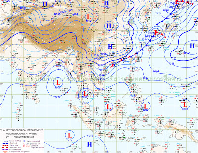
Friday, November 30, 2012

Vagaries' Contest Results for November put up on "Scorecard Page." Contestant wise Break up on "November Entries" Page.
December Page open till 15th Of December...The gap between the contestants is very narrow, and results are close...very good chances to catch up on December entries. 
Fresh entries also welcome, as they can still catch up with the current contestants..

Vagaries extreme blog again refreshed please see in between articles for new additions...
http://vagariesmum.blogspot.com/


Weekend Outlook:


The low in the Bay, 99B, lies at 9.4N and 89.3E..at 1004 mb. We have not yet numbered it. All models forecast a Westerly track. I see a westerly track of this low, and strengthening to a WML to 1000 mb by Sunday/Monday. It will approach the North TN and South AP coast by Monday. 
Chennai could see some precipitation on Monday, maybe by evening.

Cold wave is moving in in the rear of N-3. 
In Pakistan, Islamabad was 4c on Friday morning, Hyderabad saw 12c and Karachi 14c. Coldest in the plains were Nawabshah and Sibbi at 1c.
Karachi could fall to 12c and Hyderabad to 10c this weekend. Lowest  may touch  0c  in the plains of Balochistan/Sindh.

Expecting the cold to move into India from Friday night. Next 2 nights (from Friday) we could see lows of around 8c in New Delhi and 7c in NCR. Amritsar could drop to 4/5c and Chandigarh 8c.
Many places in Punjab and Rajasthan will be around 6/8c. However the coolest places in Punjab (Adampur) or Rajasthan could touch 3/4c by Sunday night (Monday morning).

Maharashtra and finally Gujarat will see a drop in night temperatures from Saturday morning temperatures. Gujarat nights will drop by 2/3c from current levels.Surat will finally drop to below 15c this weekend.
Next 2 nights, expecting Vidharbha towns to be around 11c, including Nagpur.

Mumbai will be at 20c (Colaba) and 16c (Scruz) on Saturday morning. Sunday morning will be 1c lower.
Pune and Nasik may touch 7/8c next 2 nights. Aurangabad will slide to 11c..

Moving East, cold could take Kolkata by Sunday morning, with the expected night temperature on Sunday could be 12c. On Friday morning, it was already 3c below normal at 14c in Kolkata. Days would be around 26c with North winds.

Kathmandu can see the minimum going down to below 3c, around 2/3c from Sunday night.

Thursday, November 29, 2012


Thursday N-3 snowfall in Kashmir:
Gulmarg, Tangmarg, Sonamarg, Machil, Tangdhar, Gurez, Pahalgam, Zanaskar experienced light to moderate snowfall on Thursday.
Gulmarg recorded 1 to 1.5 feet, Gurez 1 foot, Pahlagam 4 to 6 inches, Zojila got around 2 feet snow. The roads leading to Kargil, Machil, Tangdhar, Gurez, Zanaskar remained closed on Thursday.
Srinagar -Leh highway closed due to snowfall on Thursday.
Srinagar had the first mild snowfall of the season on Thursday..(estimated in vagaries' forecast)
While Drass recorded two inches of snow till this afternoon, Kargil which was the coldest place in the state with a low of minus 5.8 degrees celsius witnessed mild snowfall.

Delhi and NCR had mild to moderate thunderstorms on Thursday evening. Light drizzle had started from Thursday afternoon, leading to light and moderate rains with winds, cooling down the capital.


N-3 Precipitation on Wednesday :

Fresh snowfall occurred in upper reaches, while rains lashed plain areas of Kashmir Wednesday. Entire Valley is under the grip of a cold wave.
Reports said fresh snowfall occurred in upper reaches of Gulmarg, Pahalgam, Yousmarg and some other places. Rains lashed the plain areas since evening. 

In Punjab, Amritsar and Ludhiana had upto 0.4 mms of light rain and cloudy conditions.

In HP. Chamba recieved 11 mms of rain with the day's high at 8.5c. Manali had 4 mms of rain. In the upper reaches. Keylong had 3 mms of rain/snow.

In Pakistan, Upper parts of Hazara and Malakand divisions of Khyber Pakhtunkhwa, Kurram, Khyber  received snow. Snowfall in upper areas and continuous rains made weather cool in plains of Khyber Pakhtunkhwa, including Peshawar.
Peshawar and its surrounding areas received light shower and it was raining intermittently during the day. 
Bad weather hampered flight schedule and flights between Peshawar and Chitral which had been cancelled since Tuesday. 

Wednesday, November 28, 2012

Vagaries of the Weather -Extremes moves a bit more today with partial update of Maharashtra Page..
http://vagariesmum.blogspot.in/

Pics from Dubai Recieved from Jignesh today..on Inter Active Page..

City Forecast for next 2 days, 29th/30th November:

Mumbai: Thursday . Partly cloudy and Temperature range between 32c and 18c. 
Friday: Clear with fall of 2c in Temperatures.

Pune: Thursday: Partly cloudy. Warm day and night around 15c. Clearer by Friday with a fall of 2c in night temperature.

Delhi NCR: Thursday/Friday: Cloudy with light rain. Cool day around 22c.

Surat: Thursday: Partly cloudy. Light drizzle possible in vicinity. Thursday morning will be around 17c, but Friday gets clear and cooler.

Visit New  Extremes Blog at: http://vagariesmum.blogspot.in/


Extreme Weather and records of weather have always fascinated me. Over the years, I have gathered and "piled up" a lot of data. Yes, literally piled up, as they are in a scrap book, specially the older ones of the 1970s and late 60s. The 60s clippings from newspapers are torn and faded now. The only way of saving and collecting data then was by cutting newspaper clippings. In fact, in the early 90s, on my Mac, i had saved all the data on floppies. And the floppies are now blank, got erased within a few years...i think i am too ignorant in these things.
Now, I have decided to again compile, and share with Vagaries' fans all my data...all data will be collected and compiled and published, as and when time permts, in a new Blog: "Vagaries of the Weather- Exremes". 

This blog is available at   http://vagariesmum.blogspot.in/

Only the Mumbai Page has started, but will add new Pages as and when time permits..its a tedious job :)

Now, this new Blog is not going to be a collection of only my records, but would like all vagaries' fans to chip in and fill up a "wealth " of weather information to make this new blog full of very useful and rare information. Because i know, many of you have a lot of information and statistics to share.
Lets make this a handy and available guide to all budding and seasoned meteorologists. 

I want to finally make this Extremes blog a handy guide for all !!Extremes at a Glance! 


Wednesday's All India Minimum Temperatures Put up in Comments by Arpit>>

Monday, November 26, 2012

Progress Follow-Up: 11pm IST Tuesday:
1. A low has formed in the South Andaman, at 10N and 95E. Likely to strengthen a bit.
2. N-3 is moving East into Balochistan. May enter North Pakistan on Wednesday with gusty winds in Balochistan and Pak Punjab. The low over Arabia is now an UAC off the Oman coast. Cloudy weather for Karachi tomorrow.
x-------------------------x-------------------------------x--------------------------------x---------------------x

Posted on Monday Night:
A Low is likely to form in the Eastern Bay, East of the Andaman Islands, by the 28th of November. Initially, on 29th, it will strengthen a bit, and move Westwards, and cover the Bay Islands.
I see some hindrance in the further westward track. As of today, the SST around the Islands is 30-31c. The SST progressively decreases as we move west. And, the SST, as we reach the Southern India coast is 28c and around 27c in the NE Indian coastline. That, would deter the further westwards track of the system beyond 93E. 
In fact, there is a 40% chance, that the system could even move Northwards along the Myanamar coast.
Let me stress, that is the synoptic situation today, and my track estimate is based on this scenario.

N-3, has formed, and the trough at sea level runs sloping NE from 50E to 60E. A 1010 low is pushing into the Oman region from the West, the Arabian peninsula. 
Rains expected in Muscat and Dubai next 2 days due to this low. This Low will push NE into the coastal Iran region.
N-3 precipitation can be expected in Balochistan and Western coastline of Pakistan on Tuesday, 27th. Karachi will be cloudy.
Precipitation moves into Northern plains of Pakistan and moderate precipitation in the extreme North of Pakistan. Snow in the mountains and light rains and cold days in Islamabad on Wednesday.

N-3 moves into Northern India on 28th. Rain and snow in Kashmir, HP from Wednesday thru Friday. Thursday, Punjab, Haryana and Delhi get light rains and cloudy weather. Snow expected in Gulmarg, Sonmarg, Pahalgam and other hill resorts. Chances of first snow of season for Srinagar on Thursday.

Delhi NCR will be cloudy and cool on Thursday. Day will be at a high of 22/23c, with light rains. Nights will be around 12c.

Kolkata, dry. Temperatures at night will be pleasant at around 14/15c for the next 2 nights. With N winds, day will be cool too. Winds turn NW from Thursday.

Mumbai: Another warm day on Tuesday, with days at 32/33c. and night around 19c at Scruz and 22c at Colaba on Tuesday morning. With N winds from Wednesday, days will drop to 30/31c and nights by about 2c.

Hottest in India today, Monday, was Ahmadnagar, 34.6c....a surprise entry today. Followed by Panjim at 34.5c. Lowest in Plains, 6.8c in Churu and Maharashtra 12.3c at Nasik.


From 27th morning to 30th morning, 4 night temperatures remaining before the results of the November contest ! 


Saturday, November 24, 2012


A Branching “Tree” of Solar Plasma...See phenomenal Event on Space News Page..
See Comments for Latest Temperatures...

1.The projected  Easterly Wave,  is forming in the Central Bay, but is very close to the Monsoon trough, which runs from 5N off the Africa Coast, thru the Southern tip of Sri Lanka and into the Bay around 7N. With no embedded system, likelihood of Wave merging into the trough. 

2. N-3 on schedule, and should approach into Balochistan region of Pakistan on 26th and Northern Pakistan by 27th. 28th into Indian region.

3. Cloud moisture lingers on in N.I. Karntaka and Southern Maharashtra. Pune forecast on schedule as a result.

4. Around 27th November, Low likely to form in the Bay at location (approx) 12N and 95E. 

Total Eclipse of the Sun..Something for Astronomers..

Eclipse chasers always hope for clear skies, but observers of last week's total solar eclipse in Australia discovered that clouds can add a surprisingly beautiful twist to the brief minutes of totality.

Thursday, November 22, 2012

 Saturday Morning All India Minimums Updated in Comments..Thanks Arpit.

Posted Friday Night:
Strong Surface winds likely, sometimes gusty, likely in Northern Pakistan Punjab, Hills and plains of HP and Kashmir region from Friday night....

N-2, has moved NE, and on Thursday, is precipitating over the Extreme Western Hills of HP and Utterakhand.
In Kashmir, on Thursday, Srinagar was 14c in the day, Gulmarg and Leh saw the highest as 4c.
The system is expected to move away by tomorrow (Friday). It will not effect Nepal.

Forecast for Friday 23rd, Saturday 24th and Sunday 25th :

Pakistan: A drop in temperatures will follow N-2. Though the drop will not be severe, we can surely expect a drop of 2/3c in Northern Pakistan, that is Punjab (Pakistan) and about 2c in Sindh and Karachi.
In fact Karachi saw a fall of 2c today morning (Thursday) as the low was 14c. 
Interior Sindh and Balochitan may see the lowest at around 2c or 3c next two nights. Hyderabad will see the temperature drop by 2/3c to around 14c and Sukkur may drop to 10c and Islamabed may see 9c.

Nepal will remain dry. Kathmandu may see the temperature dropping from todays 4.8c, by another degree to about 4c, as Westerlies from N-2 prevail. Windy day may see the day around 21/22c.


Northern Region forecast for Friday 23rd/Saturday 24th/Sunday 25th: A fall of 2/3c in the next 3 nights for Rajasthan, Punjab, Haryana and Delhi. Lowest in Rajasthan may be around 4c.
Delhi NCR will have cool windy days, below 25c, and nights dropping to 8/9c for the weekend. 

Next WD, N-3 , will arrive in the Sub-Continent around 28th of November.
Dubai gets its primary showers again on the 26th.


Southern Region 3 days forecast: The Easterly wave, with an UAC embedded in it has now started pushing inland, taking the Tamil Nadu route. It will penetrate rather quickly into interior TN and precipitate modertate rainfall in the state. Effects of the UAC moving in, and dissipating, will also be felt in N.I. and S.I. Karnataka, including Bangalore, from Friday.
Hyderabad can recieve light showers on Friday. Rainfall "spill over" effect may be felt in Goa and adjoining extreme South Maharashtra on Saturday.
Chennai can expect 20/25 mms on Friday and Saturday.

Rainfall decreases in TN on Sunday. 
A re-freshed Easterly wave pulse moves into TN on Monday. Very difficult to judge now, but seems it could be a bit more Southerly.

Kolkata will be dry. With NW winds, the days will be pleasant at 28c, nights droping from the current 19c to 17c on the weekend. Monday/Tuesday we may see the nights go further low to 15c.

Mumbai: Friday/Saturday/Sunday. With NE winds in the day, day temperatures will remain around 32/33c. Weekend lows will however from from todays level by around 2/3c. 
Projected temperatures would be around 16c for Scruz and 20c for Colaba. 
Next week, a rise in the night temperatures is expected.

Pune: Temperatures have dropped (compared to previous 2 nights)by the estimated 2c, and is around 13c as on Thursday. 
Friday and Saturday morning will be around 11/12c. But, Sunday morning low, with a bit cloudy would rise to 15/16c. Sunday will be partly cloudy.

Next WD ? Next Low in Bay ?.....Weekend forecast will be up here tonite ( Thursday) by 11.30pm IST...


Tuesday, November 20, 2012

Upper Level Chart has the Low (BB-11) super Imposed to show exactly what is happening now...Easterly Wave dragging  and "consuming"  the Low ..as was estimated yesterday..
see ** marked below


N-2 precipitation enters Western Pakistan's Balochistan region from Wednesday, 21st. Precipitation can be expected from Wednesday thru Thursday in Balochistan, Northern Punjab and Extreme North Pakistan mountains. Punjab(Pakistan) will be cloudy.

Winter nights will commence in Sindh from Wednesday 21st and for next 2/3 nights, will see the temperatures drop by 2/3 c. 
The lowest in plains on Tuesday 20th was Sibbi at 2.5c, and Quetta AP was -1.5c. Islamabad was 25c today(Tuesday)in the day.
Karachi can expect around 15c and Hyderabad 12/13c next 2 nights. Initially, Islamabad will see rain on Wednesday, and a drop in night temperatures subsequently.

As N-2 moves into India, it encounters the ridge, and may weaken. Thus, what can be expected is rain and snow in Kashmir, HP on Wednesday 21st and Thursday 22nd. Snow could be expected in the Hills of Kashmir, and upper reaches of HP.

Delhi NCR will be see high clouds and cool NW winds from Thursday 22nd. Drop in temperatures by 2/3c from Thursday 22nd night. 
Similar weather estimate for Chandigarh. Nights getting cold after Thursday in Rajasthan, Punjab and delhi NCR.

In the South, the current Low in the Bay prevails in the vicinity and is "aimless' and without direction.Will become an UAC tomorrow.

**The Easterly wave trough will soon consume the moisture from the UAC. On strengthening, the easterly trough will move Westwards as is the normal with such easterly waves. 

Precipitation along TN coast and interior TN from Thursday. Heavier along coast.

Mumbai  Colaba and Scruz were 33c on Tuesday. Wednesday will however be around 31c, with N/NW winds. Night on Tuesday will be milder, with Wednesday morning seeing  18c in Scruz and 22c in Colaba.
A drop in nights expected from Friday (morning temps).

Pune will be getting East winds next 2 days. Hence a rise in the night temperature from the pleasant 8.6c..maybe to around 11c. Days will be around 29c.


Dubai Today on InterActive Page...
An Interesting and worth learning Phenomena in Meteorolgy..Cloud Streets...on International Page . A must see for Freshers in Meteorology. 


Monday, November 19, 2012

Todays picture from Dubai on Inter Active Page....notice the sky colour..


A high pressure ridge runs from Gujarat thru  Rajasthan/Sindh into Northern regions.
The fresh WD , N-2, approaching Northern Sub-Continent is to be affected by the current ridge across the region.  
The WD, currently as a trough along the 50E line, is seen precipitating in the Persian Gulf area. Moving into Dubai tomorrow.

Will approach the Pakistan Northern regions by Wednesday 21st. and into North India by Thursday, 22nd.  In all probability  the encounter with the ridge will make it track Ne into the Northern states of Pakistan and India.
It can bring cold days in the region due to cloudy conditions. Rain/snow in Kashmir/HP and Utterakhand hills on 23rd/24th. Middle ranges of Gulmarg/Pahalgam and Sonmarg can get snow.
Partly cloudy weather for Delhi NCR on Wednesday/Thursday. 

An Easterly wave aloft at 850 hpa, in the Southern Bay,  moving in westwards would be energised by the ensuing pulse in the Eastern Bay. 
Would form a trough along the 10N line by Tuesday. 

The remnants of BB-11, by then at 1008 mb,( or maybe as an UAC), can merge into the trough, thus sort of energising it (the trough). 
Rainfall from the merger will bring relief to TN coast from Wednesday/Thursday. CAPE is seen increasing off the TN coast by Thursday.
Chennai will get some showers on Wednesday night or Thursday.

Mumbai City will see a minimum of 21c and Scruz a minimum of 16/17c on Tuesday morning. However the day temperature in the city/suburbs will rise to 33c with East winds.

Kolkata dry with NE winds turning North by Wednesday. Drop in temperatures from Thursday morning. Misty on Friday morning.

Pakistan: Karachi which saw a high of 31c, still remains at around 19c in the night. 
Karachi, Hyderabad (Sindh) and Sukkur will see the nights cooling down as N-2 passes by Thursday. Expect 15/16c in Karachi and 12/13c in Hyderabad.
Monday 9 pm:

BB-11 fades away as a low at 1005 mb..fizzles out at 15.2N and 86E..same position for last 12 hrs....seems "realistic" does it not ?
updating blog tonite on this ....

Monday 12 Noon post :

BB-12 has not moved much and its elongated centre is at 15.1N and 86.1E..no movement in last 3 hrs. 
The central peninsula regions are enjoying a cold wave and a dip in night temperatures. But, this has almost "smothered" the system. Dry air wrapping round the system has caused the convection to die down and now the clouding around the system has lost all convectivity and is at an average temperature of +10c and outer spiral clouds at +16c. 

A WD can be seen in the far west, and moving Eastwards. Should arrive over Dubai by tomorrow. Northern Pakistan will see its effect from Tuesday evening and over India the next day.
Northern Pakistan regions will get rains and snow over the hills from Tuesday night...cold conditions in the day...


Monday Morning (10 am IST) sees BB-11 as a depression (T-1.0) and pressure at 1003 mb. Winds are just about 20-25 knts, and the clouding has thinned out and are non convective, at an average temperature (CTT ) of 10c. No precipitation around the system ...though a weak centre still holds on at 15.2N and 86.2E ...New Low emerged in the Eastern Bay at 1008 mb. Shall number it if required...maybe a final report around noon ?

see Abhijit's comments giving Monday morning lows in Maharashtra..check Arpit's list.

Sunday, November 18, 2012

Monday Morning (10 am IST) sees BB-11 as a depression (T-1.0) and pressure at 1003 mb. Winds are just about 20-25 knts, and the clouding has thinned out and are non convective, at an average temperature (CTT ) of 10c. No precipitation around the system ...though a weak centre still holds on at 15.2N and 86.2E ...New Low emerged in the Eastern Bay at 1008 mb. Shall number it if required...maybe a final report around noon ?

see Abhijit's comments giving Monday morning lows in Maharashtra...


Update as at 11.00 pm IST Sunday:

BB-11 is back to its deep depression status. at 1000 mb and located at 15.8N and 87.4E, it has moved just 20 kms west since the last report (on current page). But core wind speeds are at 65 kmph in the NE quadrant, where the maximum clouding is recorded. The SW quadrant is sheared away, and winds there are at 25 kmph.

The Southern mainland enjoying the cold wave, has resulted in the dis-intensification of the system. Dry cold air pushed into the system. The cloud top temeratures are almost down to 7c now. Not showing much convectivity.

Expected to weaken and move W/NW.

The pulse mentioned in the Gulf of Siam (vagaries' last report) has moved into the extreme eastern Andaman sea as an UAC. Will start telling its effect on BB-11.


For  update (5 and 8pm IST) on the BB-11 , see on Current Weather Page....also check cold wave in Mah and Karnataka report on Current Weather Page


Editorial Note: 

Colourful forecasts and very frequent changes in track forecasts have cast a shadow on the reliability and accuracy of model forecasts. True, all models go as per their computers, fed with the current parameters, but all including popular US model computers are in no position to accurately estimate the possible changes in the parameters they depend on. All judge from the possible computed estimates of wind shear, SST, pressure ridges, winds aloft and surrounding conditions.

Course of Events:

Initially, the events started much before this system was born. With this Vagaries' write up on the 10th of November: "The Arabian Sea UAC will not sustain beyond 24 hrs, hence the on going medium rains in Kerala and coastal Karnataka decrease after Tuesday.
But the Bay system will move NW, initially as a UAC for the next 48 hrs. It will descend as a Low, (BB-11)by the 14th of November, around the 8N and 85E region, East of Sri Lanka. The system, BB-11 will move NW towards the TN coast as a depression." 


On 12th November, BB-11 formed South-East off Sri Lanka. Generally, all models expected that this system will move North and will be overcome by another system expected in the Eastern Bay, BB-12,. Almost all models forecasted the growth of BB-12 into a DD and move NE into Bangladesh or further North-Eastwards.


Vagaries stated on 12th: "The tracking of BB-11 and BB-12 will depend on the tilt of the trough."


Taking its own course and time, BB-11 moved North instead, and after 4 days suddenly started gaining strength. As mentioned in Vagaries then, BB-12 has been a let down, allowing BB-11 to gain strength. 


BB-11 ,with no counter system, took the advantage to form into a Deep depression today. Meanwhile moving slightly NW. Vagaries had published that another weak system may still push BB-11 into Orissa.(With a maybe?)

As on Sunday, almost all models now, observing the changing parameter, expect this to become a cyclone, and move SW. If proved correct, it would be an absolute "un-realistic" course and direction. Very rarely (cannot remember when) have I seen a S/SW direction for such a long distance travel of a system in our seas.

But, a pulse is seen forming and very slowly trudging into the Bay from the Gulf of Siam. Vagaries feel, even an UAC from this will help maintain its W/NW track (from current position).


x------------------------------------x-------------------------------------x-------------------------------------x
An All-in-One: All models forecast at a Glance for the Deep Depression  here: and click on Models "Dynamical:

All models now predict a SW bend for the system...check in the link above....

Currently absolutely stuck at 16N and 88.5E...jerky movememt indeed...a spurt in 4 hrs yesterday, and now stuck for the last 6 hrs....


Saturday, November 17, 2012

Position as at 11.30pm IST Saturday: Again same stationary position at 16.1N and 88.5E and same strength...due to strong pull of the jet streams , the systems expected to move NW. Kolkata getting cloudy with moderate rains Sunday.


Position as at 8.30pm IST : Almost stationary at 16.1N and 88.5E and 1000 mb...


Situation changes rather Dramatically within 3 hours:

BB-11 strengthens into a depression and then into a deep depression within 3 hrs. At 1000 mb, it's centre  is about 725 kms east of Kakinada (AP).
Expect it to track N/NW and move into Orissa North of Bhubaneshwar. Very heavy rains for Orissa coast and adjoining W.Bengal coast. Kolkata can get showers from tomorrow.


Since the system is changing shape and track rather fast...next update at 10 pm.


Friday, November 16, 2012

Updated Saturday Morning


***** Refer "Whats to happen Now" below 

BB-11 has defied and challenged ALL International weather models (not comparing Vagaries with them) and taken its own course, first North and now West. 
Positioned at 13.6N AND 88.7E, West of Chennai.

It is necessary to understand the forecasts and estimates given by various models. No model goes on guess work. There are certain presumptions and assumptions, with reasoning behind each forecast. And, forecasts may be diametrically opposite to each other. 

a) NOGAP as on today (Friday) forecasts a W/NW movement towards TN/AP coast, and become a depression. (http://ow.ly/i/18830)
Vagaries also had subscribed to this view from the initial stage. The reason behind this forecast by all models: TD-25 was to send in a pulse, and form a low/depression (BB-12) in the Andaman region by the 16th and influence the initial movements of BB-11. The advent of BB-12  would have curved the trough in which BB-11 is nestled towards the West. And, the 200 hpa jet streams were seen flowing towards the NW in the Southern Bay. 
BB-11 would have moved into TN as a depression.Though some models like IMD GFS and FNMOC had mentioned this track, they changed it as they observed the change in the jet streams and pressure "play" in the Bay. 

b) Some models predicted, FNMOC, UKM, COLA a North/North-East track, presuming the ridge in the Bay will prevail. Ridge ? Yes, instead of a trough. This ridge in our seas was dependant on the High in the Phillipines region.TD-25 was nestled between these 2 Highs. 

What's actually happening now ? The extreme East Phillipines ridge has weakend, the TD-25 is fizzling out, the parent pulse itself is fading.
BB-11, is now moving West. But, the low is stagnent in strength, and seems to be getting elongated. Now, this elongation was expected, and BB-12 was to get more strengthened by merging in this "big" low. But where is BB-12 ? 

*****Ok, leave all this, what's to happen now? What can happen if BB-12 does not come ? Well, BB-11 will be on its own, and merge into the larger region of 1008 mb. Till survival, NW movemnet not ruled out for the next 18-24 hrs. That is, it will elongate to form a huge Low region of 1008 mb(weaken) in the Bay. Showers will push into Oriissa/West Bengal coast from 18th/19th.
Showers also possible in coastal and interior TN. 

A pre-mature Low in the Gulf of Munnar region may get a lease of life.

On Friday, N-1 moves into Pakistan and will be resisted by an anti-cyclone over Central India. Next 2 days, Northern regions of Pakistan, Northern Indian States of Kashmir and HP gets snow in higher and middle ranges of Utteranchal get rains.
Cloudy weather for Punjab and Northern Haryana with light rains in Northern plain regions.

Thursday, November 15, 2012

Latest as on 5.30 pm IST Thursday:

N-1...Stationary at 30N and 62E at 1010 mb...Movement expected: NE.
BB-11...W/NW movement and at 12N and 87.5E at 1006 mb. Movement expected : NW.

Readers, Please check all your individual entries and please inform if any corrections are needed...all alterations close 15th mid night for November. 
Entries for December open till 15th December...


On Thursday morning, Western Disturbance N-1 is now a low at 30N and 62E. As a medium strength system. Expected to move along the trough formed into extreme north Pakistan and into Kashmir, Northern most Punjab and HP....

BB-11: Several isobar charts show slightly varied positions of the low. But, summarising, i would position the system on Thursday 15th, at 1006 mb, at 11N and 90E. That means a Northerly movement from the last "Flash Snippet" put up on Vagaries.

Yes, was expecting a Westwards track for BB-11 last week. The initial reasoning was, as this low was thought to form  on 14th around 8N, and not 10N as occurred.  
It would have been a different scenario had it formed as forecasted.
BB-12,  would have "pushed" the larger Bay trough west, along with BB-11. 

Now, with BB-12 delayed a bit  vis-a-vis the movement of BB-11, i would think BB-11 would move North or NW. Today, 200 hpa jet streams are consistent at a Northerly direction, and the expected Bay trough has not gained strength. 
Still, if the next system moves in soon, we could  have a bit of a chance for  BB-12 to arrive and move BB-11 into the East Indian coast near AP/Orissa, maybe ?

Monday, November 12, 2012


Early November Smog over Delhi..the How and Why ....See Current Weather Page 


An UAC has formed off the Kerala coast, almost at sea level. Some charts even depict it as a low at sea level. Another UAC has formed at 5N and 90E. 
The 2 UACs joining "line" to form a trough aloft. 

The Arabian Sea UAC will not sustain beyond 24 hrs, hence the on going medium rains in Kerala and coastal Karnataka decrease after Tuesday.
But the Bay system will move NW, initially as a UAC for the next 48 hrs. It will descend as a Low, (BB-11)by the 14th of November, around the 8N and 85E region, East of sri Lanka. The system, BB-11 will move NW towards the TN coast as a depression. 

Rainfall increasing progressively along TN coast from 15th, and in Chennai from 15th/16th. Centre of the system will be off the TN coast on 16th...

As mentioned on 7th, another Low forms around the Andaman region, about 93E. 
The 2 system can form a strong trough. (Usually called a trough "in sympathy").
The tracking of BB-11 and BB-12 will depend on the tilt of the trough. 
Vagaries reads the situation as BB-11 moving into TN as a depression..

The coming WD, currently as a low South of the Caspian Sea region will move into the UAE (Dubai) region on Wednesday 14th. 
Dubai can expect precipitation on Wednesday. 
The Low moves into the Iran/Balochistan/Afghanistan region on Thursday, 15th. Here we might see 2 options:

a) A strong trough line is seen developing NE from the system into Afghanistan. This may literally pull the WD into the Afghan and adjoining extreme North Pakistan areas.

b) The trough mentioned remains weak and not effective. In that case, the WD will be allowed to move E/NE, and move into Northern Pakistan and Northern Indian regions. Precipitation can happen in Kashmir, HP and plains of North Punjab (both sides).

Friday, November 09, 2012


Vagaries' events sequence till 18th November, estimated on 9th November, Night:

1. A low ( BB-11) can form in the Bay, East NE off Sri Lanka, around the 10N line, by the 14th/15th of November. Initial pressure 1006 mb

2. Tracking West/North-Westwards, centre  will Strike Northern Sri Lanka by the 15th, and move into Tamil Nadu between Ramanathpuram and Nagapattinum by the 17th of November. Indian coast hit pressure 1004 mb, as a depression.

3. Moves inland, with good rainfall in interior TN, specially S.I. and Nilgiri Mountains and S.I.Karnataka on 17th/18th. 

4. Moves into Arabian Sea as an UAC around 18th November. We've moved too much into the future, will halt now...and monitor the scenario..

5. Another Low  (BB-12) forms near the Andaman Islands by the 18th of November...

6. Weak WD on schedule for extreme Northern region around 12th November.

We shall track the events developments daily (specially after 13th), and intimate the changes , if any....
(These are my personal views, and for commercial use ,please refer your local met Dept).

Forecast till Sunday as put up in chart on Wednesday...

Contest Date closing on 15th November for the Month..please fill in/ correct  your entries...

Wednesday, November 07, 2012

Posted on Wednesday Night 11 pm...
Forecast for the next 4 days..Thursday 8th Nov. to 11th Nov.  Position of systems as indicative from tomorrow.


Dubai Pics sent on Thursday Morning.....on Inter Active Page..
1. UAC and "disturbed dis-continuity" around N.I. Karnataka. As per explanation in vagaries, clouding extending into South Madhya Maharashtra evn on Wednesday.
Light rains in Southern Maharashtra and N.I.Karnataka. Light rains in Pune on Wednesday.

2. UAC in South Arabian Sea within a small trough seen at 8N and 71E.

3.Previous forecast was till Tuesday, shall put up next few days forecast by tonite.

Saturday, November 03, 2012

Posted 11.45Pm Monday:

Bang on !!...UAC forms off Kerala coast at 850 hpa....weak vortex seen in S.I. Karnataka in 1200Z charts.


RAINFALL FOR TOP 50 DISTRICTS ALL INDIA OCTOBER 2012. from GSB....on Stats and Analysis Page..another quality input from GSB...

Updated @ 8.00 pm Sunday, 4th November...

For North India, earliest WD (N-1) i see is around 11th/12th for entering India, and a day earlier for Pakistan...

Waiting for more Contest Entries..Please Note, Entries can be changed/ revised Before 15th of the Month...
x--------------------------x---------------------------------x---------------------------------x----------------------x-
Posted @ 7 pm Sunday, 3rd November:
Forecast for Sunday 4th / Monday 5th and Tuesday 6th:

Sunday 4th:  Most of the clouding seen on Sunday clearing away.
Rain lingering along AP Orissa coast and Bengal coast. Heavy rainfall around Vizag. Some light rains around Goa and Chennai/Bangalore in the evening. 
Much of Maharashtra will be dry.

Monday 5th: Heavier rainfall continues around the Vizag regions. Around 2 days, areas around Vizag get good showers. 
Odd thundershower popping up around Chennai and Bangalore. 
Cloudy and light rains in AP and adjoining Vidarbha. 
Cloudy and light showers in coastal Bengal. 
Light/Medium showers increase in S.I. Karnataka and adjoining TN.

Tuesday 6th: Rains continue in S.I.Karnataka and adjoining AP and TN. 
Decrease in the other AP regions.

An UAC, with a trough running into Sri Lanka, may possibly form in the Arabian Sea off the Southern Kerala coast.

Northern India remains clear and dry. WD after Wednesday over Pakistan (maybe).

City Forecasts only for Sunday 4th/Monday 5th/Tuesday 6th:

Mumbai City: 
Sunday/Monday/Tuesday: Dry and sunny. Warm day as Easterlies dominate. Days will be around 34c. But nights will be23c on Sunday and 21c next two nights.
Outer townships also dry and cooling down after Monday by around 2c.

Pune will be dry too and cooling after Monday by a couple fo degrees initially.

Delhi NCR : Dry and good NW winds will keep haze away. Days around 30c and nights pleasant at 15c. Cooling after Wednesday.

Kolkata: 
Sunday/Monday: Remains cloudy with light rains in some parts and areas. Daily rainfall around 5-7 mms.
Tuesday: Sunny, but clouds increase again by evening. Sharp shower possible in some areas at night.

Chennai: 
Sunday/Monday: Southerly winds will dominate the days. The odd thundershower pops up in the evening lashing some areas. Rainfall upto 20 mms/ day  possible.
Tuesday: Potential of thundershower less.

Kathmandu remains dry next week. With temperatures in the 23-08c range. Expect a fall in nights after Thursday.

Pakistan also remains dry and cold weather settling in the Northern regions. Nights are cold in the Balochistan plains with Sibbi at 8c. Colder in the coming week, but dry.


Sharing a past Similar Weather situation..Chances  40% of it happening tomorrow..

Vagaries has projected a vortex (see below)  around the interior Karnataka region by tomorrow, Monday. This will be the result of a bloated (non effective) low region of 1008 mb covering entire South India. The vortex will form on Tuesday within, temporarily.

Now, out of interest, i went thru certain similar situations. I checked, that on some occasions a line of wind dis-continuity forms north of the vortex. 
That is when the low region was big enough. 
In such a case, the cloudings from the vortex can stretch into interior Madhya Maharashtra and along the Karnataka and Maharshtra Western Ghats. Maybe on Monday or Tuesday. 

Please note, I am sharing a past weather occurance, and chances of vortex spreading its clouding North are 40% as of now ....may or may not happen...

Rest forecast given Below in yesterday's blog..


First, a refresher , to continue from where we left on Wednesday. Our last forecast on 31st October, Vagaries had put up, reads:- 

"Thursday 1st November- Friday 2nd November: Rainfall can be expected all along this trough line, with the heavier falls in the region the BB-10 system is embedded. Hence precipitation spreading into interior Karnataka, Northern AP and Southern Maharashtra. Light/medium rains drifting into Konkan and coastal Karnataka.
Saturday 3rd November: If the trough remains intact and sustainable (which is questionable as it is not the season), we may see some enhanced rainfall along the Konkan belt."

Thursday/Friday , it seems was almost on stream. A little variation seen was the clouding from the system spreading more eastwards due to South feeding winds remaining strong.Some rains were reported and recorded from the interiors of the state, specially the Eastern parts . Nagpur was cool (25c) and had 17 mms, Gondia 15 mms and Kolhapur 6mms. in the day. Around Pune there were reports of light rains (0.6 mms).(Figs till 5.30pm). 

For Saturday, it is obvious the other option of the trough NOT sustaining, prevails. The trough has been miserably let down by a fast depleting BB-10, now almost over, just a small area of 1006 mb near AP/Chattisgarh border. 
A very weak trough (should we call it a trough?) runs from Goa thru South Mah thru North AP and just fizzling out over the AP coast region.
1 more day of remnant clouds in Interior Konkan, S.Mah, Vid, South Konkan/Goa and coastal AP upto Bengal.

Mumbai City: The wind vane shows a steady East. Was waiting for it to S or SE.
Partly cloudy the city remained hot at 35c. 
South Mumbai  had 2 drops falling in our area at around 8 pm Friday, but cleared off within 15 minutes. (Was out in the lawns last evening, so could manage to witness the few drops, otherwise....doubtfull).


Try your Skill in Met Forecasting. .Go to New "Contest Page" and fill up your Entries. Instructions are given on "Contest"Page. 
ALL Entries MUST come and be Put up ONLY in the Comments on THAT Page.

Friday, November 02, 2012


BB-10, is now a Well Marked Low Pressure, at 1004 mb. Located in Interior Karnatak near Davangere.
The wind speed in the E, SE and NE of the system is still at almost 25 knots. So winds in the Southerly direction are pushing North along the North TN coast. This has resulted in good precipitative clouding in the East and more in the NE quadrant of the weakening system. So, the rains in Vidarbha and adjoining Karnataka and AP are due to the BB-10 system.

Now, our East-West trough runs along the 15N line, and extends upto the 850 hpa level. With the BB-10 embedded in it. Sustaining power depends on BB-10.
Mumbai winds prevailing at E/NE till afternoon...

Review for next week's weather..Posted on Saturday 9th Night: With the NE Monsoon awaiting the next Low from the Bay on around 12th, the...