Co Authors: GSB, Shreyas Dhavale, Pradeep John, Dr. Vineet Singh, Gokul
Showing posts with label ENSO..EL Nino. Show all posts

Friday, March 10, 2023

9th March:

El Nino and The South West Monsoon...Instead of going into panic mode, let us first understand the  current phase and possibility of an "El Nino" situation.  

El-Nino:

El Niño refers to a warming of the central and eastern tropical Pacific Ocean that can have compounded effects on global weather patterns. El Niño events can have significant impacts on the SouthWest monsoon.


But, there is no one-to-one direct effect between El Niño and the Indian summer monsoon. The quantum of impact may vary depending on the strength and timing of the El Nino event.

Overall in history.👇
Data from 1951 shows there were 15 moderate and strong El Nino events between 1951 and 2022.

As per information form records, In this period, the Indian monsoon was deficient (-10%) in 8 years and in another 3 years the monsoon rainfall was on the lower side of the norm ( -5% to -10%).

-------------------------------------------------------------

Technical Explanatory Note of Latest Scenario:

* La Niña has ended and ENSO-neutral conditions are expected to continue through the Northern Hemisphere spring (March/April)and early summer 2023.(May/June)(as per CPC)

*Equatorial sea surface temperatures (SSTs) are below average across most of the Pacific Ocean. 

*Niño 3.4 -0.2ºC

*The tropical Pacific atmosphere is consistent with La Niña. ENSO-neutral conditions are expected to begin within the next couple of months, and persist through the Northern Hemisphere spring and early summer.

**The ONI is based on SST departures from average in the Niño 3.4 region, and is a principal measure for monitoring, assessing, and predicting ENSO. Defined as the three-month running-mean SST departures in the Niño 3.4 region.

 El Niño: characterized by a positive ONI greater than or equal to +0.5ºC. La Niña: characterized by a negative ONI less than or equal to -0.5ºC. By historical standards, to be classified as a full-fledged El Niño or La Niña episode, these thresholds must be exceeded for a period of at least 5 consecutive overlapping 3-month seasons. 

(CPC considers El Niño or La Niña conditions to occur when the monthly Niño3.4 OISST departures meet or exceed +/- 0.5ºC along with consistent atmospheric features. These anomalies must also be forecasted to persist for 3 consecutive months.)


The most recent ONI value (December 2022 – February 2023) is -0.7ºC.

Excerpts from National Oceanic and Atmospheric Administration (NOAA)

-------------------------------------------------------------

Expected Position Explanation:(As per Vagaries)


A perfect forecast of El Nino and how it will impact the South West monsoon will be seen only by May-June. Besides El Nino, there are other factors too influencing monsoons. 

So, the earliest that an initial El Nino can be called as "setting" is in June/July 2023. 

But we should  now expect an full fledged El Nino event by August-September.

Let's be Alert rather than confused.


Wednesday, March 11, 2015

El Nino....Likely This Year ? El Niño forecast indicates brightening chances of El Niño forming after June  2015.

The central to western regions of the tropical Pacific Ocean have warmed by 0.2 °C to 0.3 °C over the past fortnight, while monthly sub-surface temperatures were more than 2 °C above average over a large area for February. This is largely the result of weakened trade winds and tropical surface currents in recent weeks.

Warmer-than-average temperatures in the tropical Pacific Ocean and models indicate that further warming is likely in coming months. 

Weakened trade winds are forecast to continue, and this may induce further warming.
All international models  indicate that central tropical Pacific sea surface temperatures (SSTs) are likely to remain warmer than average, but within the neutral range, until at least May. 


indications point that SSTs will exceed El Niño thresholds. 


The most recent Southern Oscillation Index (SOI) value is −0.5 to 8 March 2015, and the latest sea surface temperature anomaly in the central Pacific (NINO3.4 region) is +0.5 °C. 

Sustained positive values of the SOI above +8 may indicate La Niña, while sustained negative values below −8 may indicate El Niño. Values of between about +8 and −8 generally indicate neutral conditions.

There is evidence that the MJO influences the ENSO cycle. It does not cause El Niño or La Niña, but can contribute to the speed of development and intensity of El Niño and La Niña episodes.
Overall, the MJO tends to be most active during ENSO neutral years, and is often absent during moderate-to-strong El Niño and La Niña events. The MJO activity during late 2007 and early 2008, which occurred during La Niña conditions, is unusual but not
unprecedented.


No strong MJO seen till mid April in our seas ( North Indian Ocean).
Excerpts from Aust.Bur of Met

 ************************************


Maharashtra continues to get rains, ending 8.30 am on 12.03.2015

The trough at mean sea level from Lakshadweep area to north Konkan now extends from Lakshadweep area to Gujarat region across coa stal areas of Karnataka and Maharashtra.

in mm (min 25 mm)

Anturli - 59
Akole - 55
Patur - 46
Vihigaon - 41
Alegaon - 40
Pachgani - 39
Dhad - 38
Amalner - 37
Ambegaon - 37
Manikodh - 35
Jawala - 35
Dhaba - 35
Amalgaon - 35
Chowka - 35
Sasti - 34
Bharwas - 34
Khaknar - 32
Shirud - 32
Agar - 31
Jalgaonamod - 30
Channi - 30
Wazar - 30
Umara - 30
Kalegaon - 29
Medshi - 29
Sanglud - 29
Sawalikheda - 28
Wadner - 28
Wadshingi - 28
Babhulgaon - 28
Wawade - 28
Khadkwasla - 27
Dhanora - 27
Akolkhed - 27
Adgaon - 26
Kalmodi - 26
Wyala - 26
Akot - 26
Pimpalgaon - 25
Ansing - 25
Kapustalani - 25
Pankanhergaon - 25
Shelu - 25
Anjangaon - 25
Jafrabad - 25
Shiravali - 25
Madh - 25
Moleshwari - 25
Raver - 25

Vagaries Rainman 

Sunday, August 03, 2014

Posted on Sunday night: Mumbai City, after low rains on weekend,  may see increase in Rainfall to 30-35 mms/day  on Monday 4th and Tuesday.
Outer Townships get increase compared to weekend...

El-Nino Status 2014....prepared on 3rd August 2014.

The El Nino 2014 has stalled ! And Neutral Conditions Continue.

ENSO to develop requires the Sea Surface Temperatures to warm up. And the warming should go beyond the +0.5c anomaly. For this, the atmospheric support is needed. And that is suddenly lacking this last 15 days. ENSO can develop into El Nino with the assistance of both the sea and atmospheric parameters.

As a result, the Sea surface temperatures have stopped warming, in fact cooled a bit. Our region concern is the NINO 3.4...it has cooled by 0.3c last 15 days, and that anomaly is near about the long term average.


SOI (Southern Oscillation Index) last observed was -5.2. Certainly refraining us from calling it an El Nino event .

The strong MJO wave has moved East, and Negative OLR anomalies (enhanced convection and precipitation, blue shading) were observed near Indonesia and in the western Pacific. Factors related to this like Kelvin Wave and Tropical Cyclones have influenced the convection.


In 2nd and 3rd week of August, our seas can get a "Neutral MJO" condition..
Normally, MJO forecasts are most accurate when the MJO event has started. That is when enhanced convective activity starts developing, and the "wave" propagates Eastwards.

Ocean Nino Index. This index should be +0.5 for 5 consecutive overlapping seasons. Current Index is 0.2.

The Aust. Bureau of Met has given the "Watch" status to the event.Given recent easing in conditions and model outlooks, if an event when occurs, is unlikely to be strong. 


Hence, formation of Proper El Nino difficult to occur before November 2014. 

Vagaries Contest July Results are out - Checkout your July score and overall standings and also participate in August Contest. See contest page for more information.


------------------------------------------------------------------------------------------------------------------------------------------------------------------------------------------------------------------------
BB-6 on Odisha..Report see Current Weather Page & See Mumbai Page for Rohit's Presentation

Sunday, February 02, 2014

El Nino - La Nina

 Pradeep has put up the Hill Sates rain amounts from F-1 on his Page..

See Update on F-2 and latest as on Wednesday Night on Current weather Page 

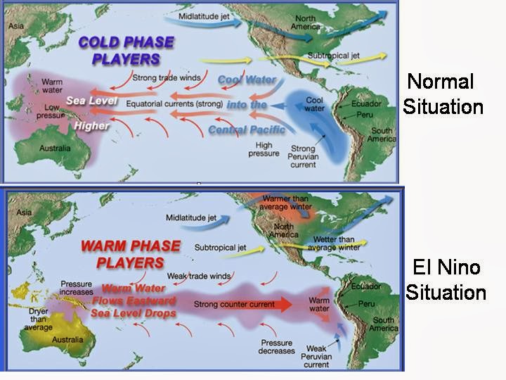
What is El-Nino, La-Nina and Normal Scenario...Simplified

The name El Niño is believed to have been coined in the 19th century after Peruvian fisherman observed it around Christmas – the word is Spanish for "boy", in reference to the infant Jesus Christ. La Niña, the word for "girl", was devised later to label the reverse phenomenon.Both are significant markers of global climate fluctuations.


In Normal Scenario, In the vast Pacific Ocean, the water goes West from the Peru Coastline. So does the air. Why? Because the surface of the ocean is joined to the bottom of the air. Now the water is an easterly current going to the west, and so is the air, and this produces easterly winds. Easterly winds bring moisture from the sea and by the time they arrive on the Australian coast they are rain-laden.


The combi-nation of cooler easterlies and lower pressure brings rain. This is the NORMAL situation. 

But it doesn't last. The movement of water to the left eventually makes the sea level higher on the left, just as a very slow-moving ripple wave would in a bath. When it gets to a critical height difference, about 62cms, it wants to go the other way. Slowly the water starts flowing to the RIGHT. Higher pressure now is on the LEFT, above Australia. And higher pressure flows towards lower pressure.The water is joined to the air and produces westerlies. The warmer water arrives at Peru and is called El Niño.

During an El Niño event, the easterly trade winds converging across the equatorial Pacific weaken.  This in turn slows the ocean current that draws surface water away from the western coast of South America and reduces the upwelling of cold, nutrient–rich water from the deeper ocean, flattening out the thermocline and allowing warm surface water to buld in the eastern part of the basin.

El Niño occurs every two to seven years, when the trade winds that circulate surface water in the tropical Pacific start to weaken. The result is a major shift in rainfall, bringing floods and mudslides to usually arid countries in western South America and drought in the western Pacific, as well as a change in nutrient-rich ocean currents that lure fish and make them migrate.

The last El Niño lasted from June 2009 to May 2010.


An enhancement of the "normal situation" is La Nina. Same winds and flow, but stronger. Averaging about 2-3 years after the normal occurrence.

El Niño is often followed by a reverse swing  with La Niña, characterized by unusually cool ocean surface temperatures in the central and eastern tropical Pacific. In fact, very simply put, when the normal situation reaches its maximum point it is called La Niña. 
The last La Nina ended in April 2012.

El Niño and the Southern Oscillation, also known as ENSO is a periodic fluctuation in sea surface temperature (El Niño) and the air pressure of the overlying atmosphere (Southern Oscillation) across the equatorial Pacific Ocean.

The Southern Oscillation compares variation in sea level barometric pressure between observation stations at Darwin, Australia and Tahiti.  It is quantified in the Southern Oscillation Index (SOI), which is a standardized difference between the two barometric pressures.  Normally, lower pressure over Darwin and higher pressure over Tahiti encourages a circulation of air from east to west, drawing warm surface water westward and bringing precipitation to Australia and the western Pacific. 
When the pressure difference weakens, it is coincidental with El Niño conditions,

Although the exact initiating causes of an ENSO warm or cool event are not fully understood, the two components of ENSO – sea surface temperature and atmospheric pressure are strongly related.  

The strengthening and weakening of the trade winds is a function of changes in the pressure gradient of the atmosphere over the tropical Pacific.  Ironically, the warming of the sea surface works to decrease the atmospheric pressure above it by transferring more heat to the atmosphere and making it more buoyant.  
So, in summary, the pressure gradient affects the sea surface temperatures, and the sea surface temperatures affect the pressure gradient.


La Nina Summer 


El Nino Summer


Southern Oscillation Index:
The Southern Oscillation Index (SOI) has risen over the past two weeks, though this is thought to be largely due to short term local weather variations rather than larger scale climate shifts. The latest approximate 30-day SOI value to 26 January is +10.0.
(Sustained positive values of the SOI above +8 may indicate a La Niña event, while sustained negative values below -8 may indicate an El Niño event. Values of between about +8 and -8 generally indicate neutral conditions.)

Current Position:
El Niño–Southern Oscillation (ENSO) remains in a neutral state. The latest NINO3.4 sea surface temperature anomaly is -0.3 °C. The 30-day Southern Oscillation Index (SOI) value to 26 January is +10.0. 
Negative OLR anomalies  were observed over Malaysia, Indonesia, the Philippines, and the 
equatorial western Pacific. Positive OLR anomalies were evident over the central equatorial Pacific. 
Low-level (850-hPa) winds were near average across the equatorial Pacific. 

ENSO-neutral conditions continue.
• Equatorial sea surface temperatures (SST) are near average across much of the 
Pacific Ocean, with regions of below average SST in the east-central Pacific. 

What is the Positional Outlook for remaining months of this year  ? Specially for the South West Monsoon -2014 ? 
WMO cautions forecasters-" "Some caution should be exercised when using long-range outlooks made at this time for the middle of the year and beyond," it said

Some International Outlooks:

--"Current model outlooks further suggest an enhanced possibility of the development of a weak El Niño around the middle of 2014," the World Meteorological Organization (WMO) said.

-- For the first few months of this year, meanwhile, the WMO said there was a slight possibility of a weak and brief appearance of the El Niño's mirror image La Nina, which cools the ocean.

-- But overall, there is a strong likelihood that conditions in the Pacific will remain neutral, with neither an El Niño or La Nina observed.

-- Climate models suggest an ENSO-neutral state to persist until at least the end of March, with some warming of the tropical Pacific likely.
-- Some, but not all, models predict this warming may approach El Niño thresholds by early Summer.
-- The picture for the remainder of the year remains hazy, the WMO underlined.

-- Vagaries estimates a neutral State till April/May. Now, we are concerned with the SWM position, and remember, if you go through the MW series (archives), then, ENSO or El-Nino is one of the important parameters for the South West Monsoon.
Vagaries estimates a slight tendency to warm of the SST off the Peru Coast and Nino 3.4 to warm up after June/July. ENSO can be on the threshold of El-Nino in June /July, and may show El-Nino tendency after July/August.
SWM should start of Normal", but can become tardy later...Too early for a forecast, but will get better views when we start our MW series.


Now, we hear from the famous Global Warming quarters...Climate change will cause severe Ninos and Ninas...Wow !..Meteorologists, who understand the science of climate, will vouch for the fact that : The two climate patterns are are not caused by climate change, but cause climate changes !
That's all there is to it. It has nothing to do with global warming, climate change, what make of lightbulbs we should be using. Nor does El Niño slow or speed up global warming, anymore than a wave on the ocean can control a current beneath. It is merely one of the giant cycles that rule the planet.

Excerpts from:Ken Ring  (Predict Weather.com)
ncdc NASA and NOAA. and from  Bur of Met Aust, www.geocurrents.infoand ,http://instructional1.calstatela.edu/


Akvan

 17th November  Current Intensity Analysis   UW - CIMSS ADVANCED DVORAK TECHNIQUE ...