Sunday, June 29, 2014

Yes, the rains have picked up, marginally as expected, on Monday Night...very marginal  in fact...Light to moderate showers in parts of Mumbai saw up to only 2 -3 mms overnight...
And Tuesday, the momentum was very sluggish...Good showers are reported from Ghat sections, with Lonaval seeing 13 mms on Tuesday afternoon. Abhijit from Badlapur measured 27 mms in his personal rain guage (un official)...while Mumbai saw some localised rains measuring 2.4 mms at Vagaries in the morning...Mahableshwar saw 9 mms and Bhira 16 mms on Tuesday till evening...
The Rains are seen picking up along the West Coast, specially off Goa and Karnataka coast..
More expected on Wednesday...

Our Usual Vagaries Monsoon Analysis and stats from Vagarian GSB will be up tonite on this Page at 11.30 pm IST...Good to have you back GSB..

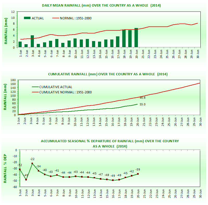
For Many Places in Maharashtra,The Driest June Ever...Compiled by Abhijit...on Mumbai Page..


Posted Sunday 29th June Night:

The Current ( Today's ) 200 Jet Stream position.

Today's 300 Jet Stream Position


And the expected normal jet stream position for the season


Will restore to this normal position with a high over Tibet by next 3/4 days.

1. The South West Monsoon is expected to move into Delhi. UP, Uttarakhand and Punjab and parts of MP in the next 3 days.
We say that the showers currently received in Punjab and Delhi NCR are pre monsoon. The current parameter we study s the 200/300 level jet streams. These are taken into consideration today as they will be guiding the Monsoon towards the West, while the sea level trough remains North of normal position.See Charts above...

Delhi NCR will get the thunder showers next 3 days, and would expect Monsoon by Thursday. SW winds will dominate. Cloudy and cooler conditions by then. 
Heavy falls in Punjab and Haryana and west UP. 
Very heavy rains expected in Uttarakhand next 3 days. Caution against flash floods.

The Northern Axis will remain for the next 3 days in the present position, therby bringing down the UAC over W. Bengal to sea level. The Low will be most probably situated over Bangladesh. 
Kolkata and most of G. West Bengal can expect heavy rains on Monday 30th/ Tuesday 1st July and Wednesday 2nd July. Would expect between 35-45 mms/day in Kolkata on Monday and Tuesday. NE States can get very heavy rains from this coming week as the anti clockwise winds from the Low rush straight into the region. Expect extremely heavy falls in Meghalaya.

As the Low moves Eastwards, Rainfall decreases in MP and Odisha. We see a decrease in rains as compared to last few days in Odisha ( BBS) and East MP regions.

2. The feeble off shore trough from Karnataka to Kerala is hosting a UAC off Karnataka. Increase in rains over coastal Karnataka and Kerala next 2/3 days.
South Interior Karnataka and adjoining TN would get some showers. 
Bangalore could see cloudy weather, and some showers of moderate intensity in the day for the next 3 days, Monday could see a thunder shower in some parts. The upper air trough along 12N weakens after Monday. Tuesday and Wednesday will be cloudy ( 31c) and some showers in parts.

Rainfall marginally picking up over coastal Maharashtra from Monday 30th. The Konkan region will see some improved rainfall from Monday thru Wednesday 2nd July, though not up to the mark required. 
Interior Maharashtra and Gujarat would remain devoid of any meaningful rains.

The trough in South India along the 12N line and the UAC off the Chennai coast seems to weaken by Tuesday 1st July. Another day of rains in Chennai and subsequently may decrease from Tuesday.


Mumbai forecast and report was put up yesterday...Yes, seems Colaba heading for its driest June EVER....and rains seem to show a slight improvement from the coming week..more so from Wednesday as declared earlier. A fresh June report tomorrow nigh for Mumbai and Maharshtra...

Pakistan:

The South West Monsoon can be expected to move into Northern areas of Pakistan initially within next 3 days
Next 2/3 days, we can expect thunder showers in Upper Punjab ( Lahore and Rawalpindi), Islamabad, and extreme Northern Pakistan regions as the seasonal low is focused in the far North of the country, and SW winds from the Arabian Sea are blowing towards the Low.

Coastal areas of Sindh and Karachi will be cloudy with light rains in the next 2/3 days. 
Monsoon arrival for Sindh seems to be delayed to some extent.
Central and Upper Sindh will be hot, with places in Balochistan and Sindh reaching 48c.
Mumbai:

Mumbai rains expected to pick up marginally from Monday 30th..gradually showing increasing trend on Tuesday 1st.
Wednesday 2nd July could see a thunder shower...from current 0 mms, Monday and Tuesday could measure upto 5-10 mms in parts of city per day..more on Wednesday.

Rainfall till 28th eveing: Colaba 55 mms..Lowest ever Record for June 91.7 mms in 1947
Santa Cruz Rainfall till 28th evening: 87 mms...Lowest ever record for June 82.2 mms in 1995...so this year NOT lowest ever.

Around Mumbai, Alibag total 95 mms, Mahableshwar 216 mms, Pune 13 mms Thane  83 mms Vasai 73 mms and Matheran 61 mms, Panvel 105 mms

Lake Levels as on 28th June: Overall Level of all Lakes at 10% of Storage capacity....Sufficient till 35 days or 3rd August.....In case of emergency, water reserved for irrigation may be drawn.


A trough in the 700 hpa level roughly along the 12N line, horizontally, brought heavy showers to Bangalore and Chennai on Saturday..with Chennai MKBM recording 62 mms till evening...

Thursday, June 26, 2014

GIGANTIC SPRITES OVER THE USA: A must See for Meteorologists..on Space Weather Page....Please read up details on Sprites again...

South West Monsoon: The Monsoon is still to track through Northern and Western India before reaching Pakistan.
Hence, as Monsoon is expected to move in Northern India ( UP, Delhi NCR and Haryana/Punjab) around 3rd/4th July. Gujarat will get light to medium pre monsoon rains from 1st July in Saurashtra and Gujarat regions. Cloudy weather in Kutch with showers.Would expect Monsoon to cover Gujarat by 4th/5th July and Rajasthan by 8th/9th July.


Pakistan:
The Monsoon cover date for Southern coastal Sindh would be 4th/5th July.
 

We can expect light pre Monsoon showers for Karachi from 1st July. Cloudy weather, with strong SW winds would welcome the Monsoon in Karachi in the first week of July.
Squally dust/thunder storms in Sindh and Thar. Sukkur, Larkana and Hyderabad regions and SE Sindh will see very squally weather.


Good pre Monsoon showers in Islamabad, Lahore, Multan and Pakistan Punjab region from 1st July..drop in day temperatures for sure.
Seeing the subsequent progress, we can expect the Monsoon advance into Upper Sindh, Central Pakistan and Pakistan Punjab be around 10/11th.


Posted on Thursday Night:

1. Mumbai: 
No major rainfall increase for Mumbai this weekend. Friday 27th, Saturday 28th, and Sunday 29th will be sunny and some passing clouds. A light shower on Saturday may just give about 3-5 mms in some parts of city. Weekend will be hot with sweaty nights.

For Mumbai, earliest i see some rainfall marginally increasing on Monday 30th. Thunder showers possible on Wednesday 2nd or Thursday 3rd July, as rain intensity increases compared to last several days.

Goa and Karnataka may see increase in rain (slightly) from Sunday 29th June, and Maharashtra coast from Monday. 
Gujarat may have to wait maybe till next Thursday 3rd/Friday 4th July..
Do not see a major change i rainfall pattern in Kerala till 4th July..continuing with current trend.

2. Interior Maharashtra is facing severe short fall in rains. 
Hill Station Mathearn has accumulated only 61 mms till 25th June...Surprisingly Low. Several staions like Akole in Nagar District and Shirur and Sangamner in Madhay Maharastra are also on 0 mms. Phulambri in Aurangabad region has seen only 5.7 mms. There are many stations with between 1-5 mms in the State.


Not "alarming" as yet, but surely we need the rains to pick up before a cut off date of 10th July in the State.

3. The UAC crossing into North AP coast will bring precipitation in the North Andhra/South Chattisgarh/adjoining Odisha regions this weekend.
Should observe if the UAC moves into Vidharbha on Monday. This could bring some much needed rains to Vidharbha region of Maharashtra.
Marathwada may remain devoid of any meaningful rains even next week, till 4th July.

4. The axis remains in the North. Monsoon may remain in current position, but possibly we may get very heavy rains in Uttarakhand and adjoining Nepal early next week. Shall keep a vigil on this situation.
Pre Monsoon Thunder showers start for Delhi NCR from Sunday, and possibly bringing in the Monsoon within the next 4/5 days by mid week.

Tuesday, June 24, 2014

Wednesday Night Posting with Latest on Mumbai Lakes and Mumbai Forecast and also Maharashtra weather...An UAC likely on 27th in Bay...See Current Weather Page..

A Visit Worth Remembering...Indian Meteorological Department, Pune....23rd June 2014 
 More Pictures on Vagaries meet Page here


Seven of us from Vagaires, Rajesh, Abhijit, Pradeep, Punnet, Salil, Junaid and Kunnal visited the IMD Pune on 23rd June 2014.The visit, hosted by the Indian Meteorological Society (IMS) under the guidance of Shri Sikandar Jamadar, Secretary, IMS Pune Chapter, was a memorable and learning experience.
Special  thanks to all officials of IMS Pune Chapter  for arranging the visit,

Welcome for Vagaries ....
Welcomed by Sikandarji, we first went to the office of Mr. B. Mokhopadhaya, DDGM, Climatology.

Conversing with Dr.Mokhopadhaya, was like going through an encyclopaedia. His vast knowledge on varied topics, besides Weather, was captivating and had us all listening.

The Monsoon axis currently in the North and subsequent a ridge sitting in Central India was discussed, with the delayed Tibetan Anti Cyclone showing a South East position. 
Patiently he answered and explained all queries on meteorology from the formation and structure of a cyclone to the upper level ridges.

After an two hour interesting session with Dr.Mokhopadhaya, we were taken to the Calibration section, and saw how the various instruments and meters are calibrated by the IMD. All measuring meters and instruments on IMD stations need to be calibrated here before use. Interesting was the "Wind Tunnel" , used for the calibrating the anemometers.


The National Data Centre was where all the Data is collected from the Sub Continent and is stored in Super servers, at 14c room temperature.The person in-charge of managing the server was kind enough to show us the servers. Further, he also explained us how the Data is collected and then distributed, and then posted on various weather websites etc. 

The NDC chief, Dr. Krishnakumar, was answering a whole lot of queries from Rainfall Data of remote places (Asked by who else but our Rainman Pradeep) to my query of certain temperature corrections that could be needed in the all time records .

We then visited the Class I weather Station (pune) where the observer expalined how the Surface temperature was measured in detail. He also explained the dry and wet bulb temperature. New additions like Rain Water Pollutant measuring and Checking instrument was shown here. 


Mrs Sunitha Devi S, Scientist, Weather Forecasting explained how the computer charts were super imposed in satellite images and the models used for analysing. The explanation meant a lot to us as it visually showed the cloud formations within the troughs and contours. The old proven method of hand drawn charts is a thing of the past now.

Sikandar ji showed and explained the intricacies of Short Term, Medium Term and Long Term Forecasting. Parameters of South West Monsoon and North East Monsoon were shown and discussed. Several Dynamic and Empirical Models were discussed. Methods of parameter importance from the old proven Gowerikar Method (to which i still swear by) to the latest shortened method with just 5/6 parameters and the pros and cons were debated. The meet end with a photo session with Salil and Kunnal in action.
We are thankful to the hospitality shown by all the IMD officials we met, answering our queries and explaining everything with patience.  

Maybe some improvement now in Vagaries Monsoon Watch :-)


Was pleasantly surprised when i came to know that a senior officer regularly follows and reads our Vagaries blog :-)

All Pics (except Main Building) Pic by Junaid...

Monday, June 23, 2014

Lowest ever Rainfall for June Month for Konkan Towns and Cities : Mumbai Colaba 91.7 mms ( 1947), Ratnagiri 236 mms (1952), Harnai 228 mms (1966) and Alibag 147 mms (1947)...total today Colaba 55 mms, Rgiri 171 mms, Alibag 95 mms and Harnai 181 mms...are they heading for Driest June ever ?


MONSOON REPORT (1-6-2014 TO 22-6-2014)
TOTAL ALL INDIA RAINFALL (as on 22-6-2014) 66.2 mm
SEASON +/- -36%
RAINFALL THIS WEEK (from 15-6-2014) 34.4 mm
TO ACHIEVE BY 30TH SEPTEMBER     mm
MINIMUM                             700   mm 6.34
AVERAGE                            890   mm 8.24
MAXIMUM                          1100   mm 10.34
CURRENT RAINFALL PER DAY  3.01 mm
TOP FIVE SUBDIVISIONS (upto 22nd june)    mm
COASTAL KARNATAKA 452.1
KERALA 409.8
A & N ISLAND 364.1
SHWB & SIKKIM 330.7
ASSAM & MEGHALAYA 266.4
BOTTOM FIVE SUBDIVISIONS (upto 22nd june)     mm
EAST RAJASTHAN 16.1
WEST U.P. 14.4
GUJARAT REGION 12.1
PUNJAB 6.3
WEST RAJASTHAN 4.4
TOP FOUR SUBDIVISIONS ABOVE NORMAL (upto 22nd june)    mm
A & N ISLAND 10%
RAYALASEEMA 4%
S. I. KARNATAKA 3%
EAST MADHYA PRADESH  2%
BOTTOM FIVE SUBDIVISIONS BELOW NORMAL (upto 22nd june)    mm
COASTAL ANDHRA PRADESH -69%
MARATHWADA -71%
WEST RAJASTHAN -73%
PUNJAB -74%
GUJARAT REGION -82%
TOTAL ABOVE AVERAGE DAYS TILL 22ND JUNE 3  (14%)
TOTAL BELOW AVERAGE DAYS TILL 22ND JUNE 19 (86%)
* data available only for four subdivisions 
source -IMD

Saturday, June 21, 2014

"Monsoon 2014..so far No good"  

South West Monsoon 2014


The South West Monsoon has now ( 20th June) covered almost half of India by area. The advance, in phases, was a bit behind schedule, but the movement has been on. 
Surprising feature this year is that the Bay branch has dominated over the Arabian Sea Branch. Normally, the Arabian Sea dominates with strong South West Winds bringing copious rains along the West coast.
But, the Cyclone Na Nauk has sucked away all the moisture from the region, and made the normally clouded Arabian Sea almost clear. 
Even a upper air vortex which formed in situ over the Arabian Sea initially revived and pulled the Monsoon into South Gujarat.. Though the upper air system did bring good flooding rains (upto 380 mms in Kodinar per day) with Gujarat getting good rains for a couple of days, and dragged the monsoon North.

Since then, its a smiling Eastern branch and a gloomy Western side. 

However, persistent WD troughs in upper and mid levels, has prevented the proper formation of the gradient for the Monsoon. 
Even the Easterly Jet stream at 100 hpa and 200 hpa levels are yet to establish in the Northern regions, and has moved upto around 22N. The core is over 13N.
The ridge East of the West Coast, and the formation of the Monsoon axis over orth India, has currently reduced the rainfall over Peninsula India.
The Tibetan Anticyclone, linked with the 200 hp jet streams, is yet to establish itself in the normal position.
I would not as yet blame the El Nino effect for this sluggish start. This phenomena has not even formed and established yet.

With a cumulative rainfall of 55.0 mms against a normal of 90.6 mms for all India, overall, as on 21st, the Monsoon deficit is a whopping -39%. In June 2009, the drought year last remembered, it was -45% as on June end. But, by the end of the season, 2009 showed an overall deficit of -22%.
The graph below shows an improved trend since the last 3 days.( Today Mawsynram got 312 mms and Cherrapunji 232 mms). 


The impact is felt on farm and crop sowing. As of now, sowing has reduced by 2.1 million hectares in 2014, shows Kharif sowing on 20th June almost 20% less than last year.

The poorest and worst June ever ( All India) was in 1926, with the deficit at -48% and in 1995 with June showing a deficit of -47%.

I would not go in for the "drought" term yet. The dreaded word is far from reality yet. We see the soil moisture and water table and level indicators (Parameters for Drought) are not alarming and not worsened. Water levels are comparable to last years levels, except in West and South India. Overall the Storage is 24% of the Live Storage Capacity.
If there is no substantial change in rainfall till end July, the dreaded word "drought" may have to looked into or declared.

Initially now, this is not encouraging. But, we hope, and we have to keep hope, that as the Monsoon progresses, more and more regions will get rains to cover the deficit. 
We can still hold on to better figures and amounts. What we cannot afford now onwards is a more than 10 days Monsoon Break at this stage.

Next Week, from 22nd June, The rainfall would be restricted to the West Coast  of India (still weak) and NE States, Odisha and Sub Himayan West Bengal. for the next 4/5 days. Some thunder storms and rain from the effect of the Northern trough would be scattered in Delhi and Haryana/Punjab next week.
Thunder storms would be also seen in Pak Punjab.
Further progress into Delhi and Punjab and Pakistan could be delayed to some extent.


Maharashtra : The rainfall in Maharashtra overall is -47% deficient. With Marathwada being the most deficit at -74%. Konkan is at -35%.
The Maharshtra water levelds in dams and reservoirs is at 20% of the live storage capacity. Last year on date it was 24%. 
Even the wet spots of Maharshtra, Mahableshwar has totalled only 200 mms, half of its normal rainfall and Amboli has measured only mms.Pune has gathered only 12 mms as yet.
There are a number of station with 0 mms in the interior of the state.

Mumbai has received only 55 mms at Colaba and 87 mms at SCruz. The lowest ever for June at Colaba is 91.7 mms in 1947, and 82 mms at Scruz in 1995. Of course, we have 10 days left in June ..so hopefully we do not break the infamous record at Colaba.


Cannot see any major change for the next 4/5 days for Mumbai..in fact would venture to forecast maybe just 20-22 mms accumulated till Wednesday.

Thursday, June 19, 2014

Posted Thursday Night:

The Low from the Bay has embedded itself in the Northern Trough. The trough has gained prominence. 
SWM would resultantly push Westwards from Bengal /Bihar region into UP and MP and Eastern Vidharbha..
By Sunday, showers will be creeping upto Delhi NCR and Haryana. Inter action with a Northern WD will bring rains to Kashmir and adjoining North Pakistan.
Delhi NCR can expect a thunder storm, could be rather severe, by Sunday..

Islamabad will be hot, 39/40c on Friday, but seeing the WD give some gusty thunder storm on Saturday/Sunday.
Karachi: Hot at 36/37c, but very warm nights at 30c as minimum. West winds and clear skies. Expect some clouding from Monday.

No major revival seen along the West Coast of India. The nominal 20-30 mms in places would continue, but no big surge is expected this weekend.
In fact, the interior regions of the Peninsula will get very scanty rains.

Mumbai: Rather cloudy with brief duration showers in parts of the city. Showers around in the vicinity on Saturday may produce around 15 mms, but Sunday may not get that lucky, and may end up with less than 12 mms.

Pune: Rather warm and humid, as day will be cloudy to some extent. A few passing light showers in parts of Pune. Rain amount upto 5 mms/day.

Kolkata, enjoy Monsoon and rains !


The All India Rainfall is running far, far below average...-45% as on 18th June...and it is worrying  !!


Wednesday, June 18, 2014

 Posted Thursday Morning: As the Low over Kolkata moves N/NW, it is seen merging with the Northern trough on Thursday morning. Still holding its identity at 996 mb, once it merges, it will weaken the South wards associated Eastern trough. This will result in the total disappearance of the ridge off the West coast in the next 12 hrs..
As explained earlier, the West coast trough weakened under the influence of the opposite coast trough, as the trough lines dipped, resulting in a crest on the West coast


Posted Wednesday Night:
SWM advances into W.Bengal, Sikkim...see map on current weather page.

Low from the Bay crosses the .Bengal coast and Moves N/NE, and merges with the Northern trough...
Did i mention Northern trough ?? Northern trough would mean a weak Monsoon condition for the interiro peninsula and lower rains along the West Coast. Increased rainfall in the Eastern UP, Bihar and Jharkahand States. W.Bengal would continue with the monsoon rains. Rains could spread Westwards towards Delhi this weekend.

While it seems low rainfall continuing for Mumbai this weekend. Interior Maharashtra and Interior Karataka Southwards expeced to get scanty rains ..

Northern Pakistan and Islamabad get the 17th/18th quota of rains..with 27 mms today in the Capital. All this while Turbat reaches 50c !
All the West bound rains from the Indian side proceed towards Pakistan Punjab this week end ?
More on the week end weather on Thursday night...

Monday, June 16, 2014

Wednesday Morning: Bay Low crosses Land through W.Bengal, and located approximately centred over Kolkata...Note, the centre is always approximated for such weak lows.

Posted Tuesday 17th Night:

The so called off shore trough off the West Coast of India has become just the opposite....its become a ridge.
And now, with NW winds cause by the ridge, what do you expect but low rainfall along the coast...all stations along the coast will get little rainfall next 2 days.

Mumbai will be partly cloudy on Wednesday 18th and Thursday 19th. Some passing showers in parts of the city will keep the rain guage from getting absolutely dry. Should measure about 5-10 mms /day next 2 days. Nights will get warm again at 28c.

Pune will be partly cloudy and at around 33c. Light rains by evening in some parts.

The Low in Northern bay will cross into land on the Odisha/W.Bengal border.
Heavy thundershowers are likely next 2 days in W.Bengal and Sikkim. Odisha and adjoining Chattisgarh too will get heavy showers. 

SWM is likely to move into Bengal , Odisha, Bihar, Jharkhand, Sikkim  and Eastern Nepal by Thursday 19th.

Kolkata and Bhubaneshwar are likely to get thunder showers on Wednesday and Thursday, with heavy rains in Northern Odisha regions.

Chennai will be hot and sultry, with days around 38-39c. The trough in the Bay could "push" a thunder storm in the vicinity of Chennai on Wednesday /Thursday.

Some isolates thunder squalls likely in Northern regions of Pakistan and isolated dust storms in parts of Sindh.

--------------------------------------------------------------------------------------------------------------------------------------------------------------------------------------------------------------------------------------------------------------------
Tuesday 17th June Morning observation: 
With UAC over Gujarat not persisting, Trough off the Maharashtra Coast seen weakening, flattening out, and just about surviving off Karnataka coast. But, a ridge seen off Kerala coast.
Thats the reason we see NW winds off Kerala coast today...

Mumbai may not get the momentum we expected, but will continue with passing showers on Tuesday, accumulating 20-25 mms by next morning.

Mumbai Rainfall till Tuesday Morning (24hrs preceding): Scruz 31.7 mms, Colaba 6.3 mms and Vagaries 9.5 mms.

Low in the Bay is now at 20N and on the East coast. A trough runs down from the Low, right thru the Bay Centre. e can expect good heavy precipitation in the trough, that is SW, South and Se of the Low....see in the chart.


Rainfall decreases in intensity in Gujarat...Last 24 hrs till Tuesday morning, In Junagadh, Vanthali was the heaviest with 47 mms, and Junagadh city with 31 mms.
Khambhalia in dwarka region received 55 mms and dwarka town 14 mms.
Surat ended up with 9 mms, but Mangrol measured 41 mms and Olpad in the region got 32 mms. 
Bharuch measured 7 mms.


-------------------------------------------------------------------------------------------------------------------------------------------------------------------------------------------------------------------------------------------------------------------


Unexpected Very Heavy Rains in Junagadh and Gir Regions last 2 days...Some torrential Rainfall amounts from Gujarat in last 24 hrs ended as on 16th Morning..

Gir: Kodinar 380 mms, Talala 191 mms, Una 161 mms, Sutrapada 138 mms.(This was the first Rainfall in Kodinar, so the totat from 1sy June is 380 mms. Kodianar Annual Average 897 mms..
This Month's Total for Talala is 210 mms and Sutrapada 138 mms !!)


Again, 24 hrs 16th June Rain Amounts : Junagadh: Mendarda 279 mms, Junagadh City 204 mms, Vanthali 172 mms, Manavadar 134 mms, Malia 123 mms.
Porbandar: Kutiana 71 mms and Ranavav 39 mms.

In last 24 hrs, Vansda in Valsad region got 86 mms.and Valsad got 27 mms.
Surat: Olpad 36 mms, Kamrej 18 mms, Surat 12 mms.
Rajkot: Upleta 119 mms, Gondal 50 mms, Jetpur 28 mms And Doraji 25 mms. Rajkot city got 7  mms.
Tapi: Songadh 33 mms.

Mumbai rain as on 8.30 am Monday: Colaba 16.6 mms, Scruz 15.1 mms but vagaries side only 4 mms.
Other Maharashtra Amounts being compiled and will be up on Vagaries Rainman..

Sunday, June 15, 2014

Posted Sunday Night:

South West Monsoon advances upto Southern Coastal Saurashtra and South Gujarat....( Map on Current Weather Page)...Pushed into the Konkan and South Gujarat coast by the Western Coast off Shore trough, it also got a fillip into Southern Saurashtra aided by an UAC at 850 level which is S/SW off the Saurashtra Coast. Diu received 16 cms and Veraval 7 cms in 9 hrs ended 5.30 pm IST Sunday.
Would expect the UAC to merge in a upper level trough. Rains , heavy at times, for 1 more day in Saurashtra. Heavy rains in Coastal regions of Gujartat, with the Monsoon most probably rushing upto Dwarka..
The upper level trough would keep the off shore trough stable...bringing good rainfall in Southern Coastal Gujarat (Surat) and North Konkan.

Mumbai
Monday: Partly cloudy initially, getting cloudy in the day...Passing regional showers, a few heavy. By the evening, heavier thunder showers in the city. During the day, an average rainfall of 20-25 mms expected. 
Tuesday: Cloudy, with intermittent showers. Increase in rainfall over Monday.Mostly the city will get frequent showers, some with thunder, and the 24 hrs rainfall ( Tuesday morning to Wednesday morning)could measure upto 35-40 mms.
Wednesday: Overcast with occasional showers...showers in the city will bring the day temperature down, but would not measure much more than Tuesday, maybe 30 mms.

Pune will be partly cloudy, and next week will see light rain in parts of Pune. Daily rain around 3-5 mms.

Kolkata: Monday/Tuesday/Wednesday: Lesser chnces of widespread thunder showers. A few showers in some parts or vicinity of city can pop up due to convection. Due to this, the day will be hot round 39c..
Thursday onwards, we see rainfall increasing, as possibly the South West Monsoon can advance over the city.


An evening storm may be a possibility next few days in parts of Delhi NCR...

Hot days for Islamabad and Pak Punjab cities...around 41-43c...Chances of evening thunder and rains on 17th and 18th June...possibly cooling the cities and bringing temporary relief from the heat.


Moderate Rains have started around Mumbai, with IMD announcing the arrival of the Monsoon.
As on Sunday morning, Santa Cruz received 14.6 mms, Colaba 21.4 mms, Thane got 22 mms, Kalyan 19 mms, Ulhasnagar 18 mms, Vasai 18 mms.

Details from Konkan are awaited, But Vengrula received 60 mms and Ratnagiri 46 mms. 

Detailed rainfall will be put up on Vagaries Rainman Edition.

Gujarat:
Monsoon has also advanced into South Gujarat. 
As expected, Surat and Bharuch regions receieved good showers, Patan 4 cms, Bharuch showing 27 mms till Sunday morning. Valsad got 10 mms and Surat 1.5 mms.
And Rajkot region, Upleta and Doraji 3 cms.
In Junagadh, Malia got 4 cms, Visavadar 3 cms and Talala 2 cms. Even Mandvi and Naliya in Kutch got 1 mm.
Talala Junagadh Highway on Sunday...


Though the off Shore trough extends to South Gujarat, it remains weak...Report tonite by 11 pm IST.

Saturday, June 14, 2014

South West Monsoon Advancing into South Konkan and South Madhya Maharashtra on Saturday, and further North in Konkan on Sunday...
Mahableshwar received 15 mms on Saturday with a cool day with Max temperature at 22.6c...

Latest Mumbai Lake Levels from Jayesh on Mumbai Page

Yet Another Edition to the Vagaries' Group...Introducing the New "Vagaries Goa" the latest Edition to the Group. 

Vagaries Goa gives the complete weather report and rainfall details of Goa. Atul Naik, is a keen weatherman, and had participated in the Vagaries' Monsoon Watch Tutorials. His presentations and ideas were systematic and co ordinates well with the Monsoon events.
 

Atul's presentations on Goa weather, Graphics and Tabulations, will keep us updated and well informed. His contacts with the weather bureau ( Goa) are good and will be very usefull to Vagaries...Welcome Vagaries Goa !
 

Tab Added on top along with other Editions...Congratulations to Atul Naik !

Forecasted East rough  Let's look into the 3rd week of March ( 17th - 21st). Mumbai : Hot weather likely for Mumbai region this week, ty...