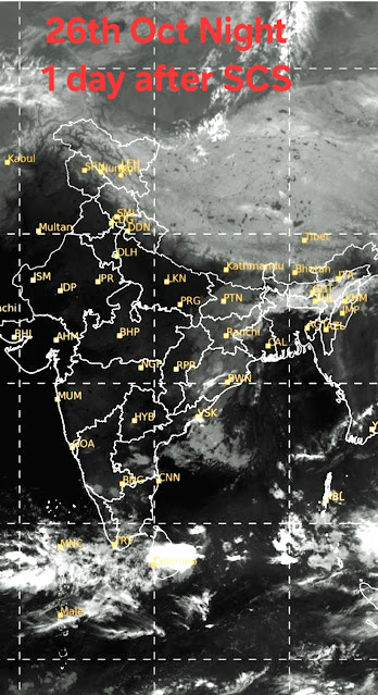
Cyclones, Typhoons& Hurricanes this week
Vagaries© of the weather.blog written by rajesh kapadia.concentrating on meteorology of the Indian sub continent and extreme world weather since 55 years For Any Information taken from here, due credit must be given to Vagaries.
Monday, October 28, 2024
Sunday, October 27, 2024
27th Night Post:
Rains that Refuse to go ! Can keep the dry October Heat at Bay.
Mild Divali dampner for Mumbai, Pune, Sambhajinagar and popular stations Lonavla, Matheran and Mahabaleshwar ?
Certain conditions can develop to produce light rains ( 7-10 mms) in the above Cities/Stations on 29th,30th,31st October and 1st November.
Reason is this Trough forming👇
Gujarat expected to be dry and hot ( 36-38°c)
Urban Heat Island Effects Have Not Yet Been Removed from Official GHCN Warming Trends
Friday, October 25, 2024
Thursday, October 24, 2024
25th Morning Scene
Storm surge at Kendrapada Dist.Odisha
Sent by Mitan
Mid Night strike
24th October updated at 23:00 IST
Several Cyclonic Storm ..DANA...Paradip Radar...
ADVANCED DVORAK TECHNIQUE
                    ADT-Version 9.1
         Tropical Cyclone Intensity Algorithm

             ----- Current Analysis -----
     Date :  24 OCT 2024    Time :   160000 UTC
      Lat :   20:04:43 N     Lon :   86:55:57 E


                CI# /Pressure/ Vmax
3.8 / 987.4mb/ 61.0ktWednesday, October 23, 2024
Tuesday, October 22, 2024
Monday, October 21, 2024
21st Night Post
Mumbai/Pune: Finally! Post Monsoon rains for Mumbai and Pune will cease from 23rd October.
As the consistent prevailing moisture " rains off ".
Rising October heat for Mumbai ( 35/37°) and cooler clear nights for Pune ( 17/18°).
But with low humidity and less 😓 sweaty.
--------------------
The unexpected and unusual post monsoon rains in Gujarat on 20th/21st October
Friday, October 18, 2024
18th October:
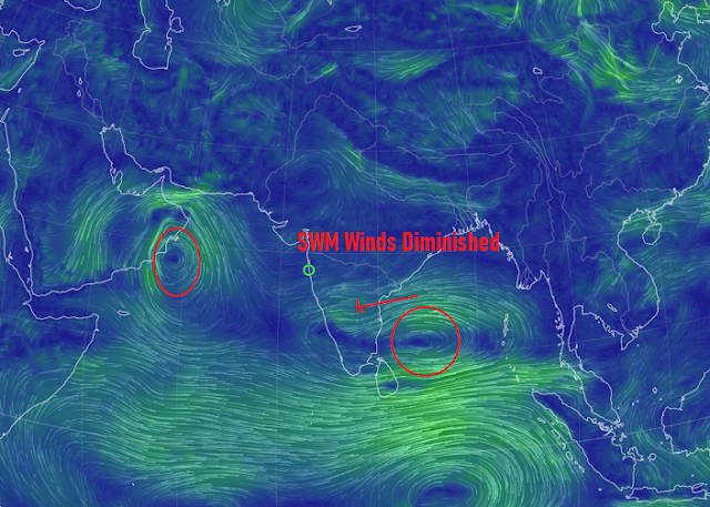
South West Monsoon winds are over....
A Low in the Arabian Sea forms to move Westwards.
Maharashtra: Due to the large incursion of moisture from the pervious Low from the Bay BB14), some pre monsoon showers will linger on in Maharashtra till 22 and October. Interiors of the State will get moderate thundershowers in localised patches till 22nd .-----------------------------------------
Mumbai & Pune: The stray localised thundershowers will pop up in the evenings till 22nd October.( Post Monsoon).
Cumulative Monsoon Rains total as on 18th October:
Colaba: 2754 mms ( 108 ")
Santacruz:3160 mms (124")
Pune :1165 mms (46")
Goa: Valpoi (197"), Sanguem (188") and Sanquelim (168") Panjim 3856 mms (152")....
Goa: Similarly, stray thundershowers till 23rd October.
South Gujarat: Due to proximity of the moist regions, Surat and South Coast will get light rains till 21st October. This includes Bharuch also.
Wednesday, October 16, 2024
Tuesday, October 15, 2024
15th October:
NE Wind directions show a gradual transition of change as the SW Monsoon winds have diminished.
The Low Pressure (BB 14) in the Bay will strengthen into a depression and cross T.N. Coast by 17th. Proper N.E.Monsoon set in will be established from 17th. However, Pre Monsoon showers in association with the system BB 14 has commenced as seen in the map
(IMD Statement on 15th October::Southwest monsoon has withdrawn from the entire country today, the 15th October 2024. Simultaneously, the Northeast monsoon rainfall activity has commenced over Tamil Nadu, Puducherry, Coastal Andhra Pradesh, Rayalaseema, South Interior Karnataka and Kerala today, in association with A Well Marked Low Pressure Area lies over central part of south Bay of Bengal.)
As the withdrawal of the SWM has begun with the change in winds, the South West Monsoon season will be over by 17th. October.
As the BB-14 system moves inland into Tamil Nadu, Maharashtra and entire South Peninsula will get thunder showers from 16th to 19th October. We can associate these rains with the advancing North East Monsoon system.
Mumbai: The transition of season change has started with reversal of winds. As the Monsoon withdraws by 17th, Mumbai can get the few local evening thunder showers from 16th to 19th October. Post monsoon rains in Mumbai have been witnessed before.
Pune: Getting warmer, but local thunder showers will continue till 18th October.
Saturday, October 12, 2024
ISRO’s satellite imagery shows significant expansion of glacial lakes in Indian Himalayan river basins, aiding in climate change adaptation
See Author's Page
Auroras sighted in Leh: How a solar storm led to this rare phenomena...See Space News Page
Friday, October 11, 2024
11th Night Post:
The Well Marked Low ( AS- 3) in the Arabian Sea is keeping the Monsoon " alive" in Maharashtra and rest of Peninsula India.
Now, AS-3 is expected to move away Westwards. But, we have another Low ( BB-14) in the Bay surfacing by 14th October.
BB-14 is expected to strengthen into a Deep Depression and strike T.N. with heavy rains.
Subsequently, as the system is strong, it will cross South India and re emerge in the Arabian Sea as a Low around date 17th/18th. So, effective thunder showers will continue till 19th in Maharashtra, Goa and Mumbai.
Mumbai and Pune will continue to receive a the evening " retreating" thundershowers till 19th/20th October. Intensity may decrease, and showers quantum may vary daily and on a few days will be localised.
Sambhajinagar (Aurangabad) will get thundershowers on few days till 20th October.
Gujarat: Rains/thundershowers continuing for another 3-4 days.
Saurashtra, Bharuch and Ahmedabad regions can get rain till about 14th October.
South Gujarat areas of Navsari, Valsad, Surat can get rain/thundershowers till 15th October.
Weather after 15th depends on the track of the new low from Bay of Bengal.
Thursday, October 10, 2024
*10th October...3hr rainfall from 7.15pm to 10.15pm in Mumbai (BMC)*
B Nadkarni Park Mun. School, Wadala : 70.8 mm
Talchekar wadi Mun. School, Lower Parel : 64 mm
Worli Fire Station : 63 mm
MHB Mun. School, Malad: 62.6 mm
Gokhale Road, South Mun. School, Dadar: 62.6 mm
Supari Tank Mun. School, Bandra: 55.4 mm
Sewri Koliwada Mun. School, Sewri: 53.8 mm
Thursday 10th 8.30 pm
Wednesday, October 09, 2024
Tuesday, October 08, 2024
Posted 8th Night:
South West Monsoon Limit line 👇
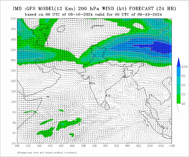
Conclusion drawn by few parameters, but the prominent factor is, Anticyclone Winds in the North/West Region 👇and the Westerly 200 hpa winds in the North.👇👇
Moderate-heavy thundershowers likely in Interior Maharashtra and Ghats from 11th - 15th October. Heavy localised thunder showers in Marathwada on 15th.
Sunday, October 06, 2024
Posted 6th Night:
Mumbai:
7th - 12th October: Partly sunny in the day till late afternoon.
Thunder clouds forming from late afternoon in the East, could drift over parts of Mumbai. Resultantly could give moderate rate thunder showers. ( 20-40 mms per day)
11th/12th could get a heavy thundershower. (Exceeding 30 mms).
Monsoon Persisting till 15th October.
A Low Pressure ( 1004mb) may form in the Arabian Sea Off the Kerala Coast by 12th October. The wind systems and High pressure ridge in NW India and Shear indicate the System to strengthen to 1000 mb by 16th. Tracking NW away from West Coast.
Pune:
7th-12th October: Sunny warm day, with thundery developments by afternoon.
Clouds can drift over parts of Pune to produce thunder showers. ( 10-15 mms per days).
Monsoon persist till 15th October.
Aurangabad:
Expect retreating thundershowers from 9th - 13th th October. Heavy in small pockets.
Monsoon over by around 15th October.
Gujarat: Main monsoon current can be declared as withdrawn by 8th, as the dry winds from North) have started.
But, some stray showers can be expected in South Gujarat Rigion( Surat, Bharuch) on 12th -15th October.
18th July Rainfall in cms

-
Much Awaited Monsoon Analysis to Date from ..None Other than Our GSB..on "Stats and Analysis" Page..Just Recieved On Saturday ...
-
Short Narration: Monday 1st/Tuesday 2nd : The heaviest rains are in Madhya Maharashtra, Marathwada, North Interior Karnataka and No...


