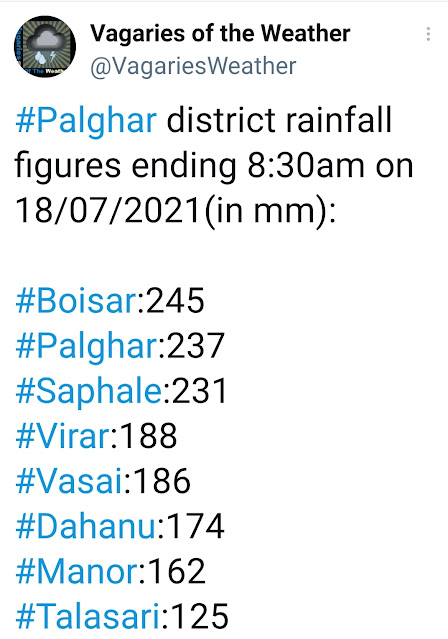
Posted Sunday 18th Afternoon:
Unexpected Cloudburst in North Konkan and specially Mumbai on Saturday Night into Sunday.
Off shore trough activated due to vertical wind shear (surface winds are SW and 700 at N. CAPE is favourable.
Because of this, there was strong Thunderstorm formations along the coast.
North Konkan and South Gujarat coast "jump" the forecast and leap 1/2 days ahead ! This "jump" Good for the Lakes*.
The outlook remains as given earlier, (though advanced by Nature to show its "Vagaries'' to Vagarians) 😉
Good rains ahead for Mumbai and Lakes.
Overall Storage at 19.83 % ( 2020 this date 26.71% and 2019 was 50.78%.)


4 comments:
Thanks for this posting, Abhishek.
These downpours in a small region seems to be becoming more common.
The rain was more around midnight (in Andheri). It's stopped raining since long but the waters haven't completely receded yet.
IMD orange-red alert for entire MAHA.
What is happening every year for MAHA- Konkan soon may emerge as world heaviest rain spot.
Navi Mumbai non stop 24*7 torrential rains.
Much needed rains for the lake regions in Mumbai. Hope the next few days bring in more for the catchment areas.
Excellent crisp updates from Vagaries meanwhile. Thanks Rajesh, also, for the detailed forecasts for both Maharashtra and Gujarat.
Suresh
extreme non stop rains over Mumbai. NDRF in force.
We are in mid july already ready to cross 2000mm ! Will this be ATR ?
3 more months left !
Post a Comment