Posted 4th June Night
Vagaries' views on SWM situation 2022:
1. Monsoon currently as a establishing current over Kerala.
2. Due to prevailing SW winds not having depth, current remains weak. But shear zone forming likely at 700 at 15N, and Westerly Winds strengthen South of it. The Zone then can move North.
3. 200 jet streams however show good signs and indications of season change in next 4 days.
4. With 200 jet streams possibly becoming Easterly by 9th june, but lower winds still not SW, we have a complex situation.
5. Resultantly, an offshore trough can form (due to core off 200 ) off the West Coast.
6.
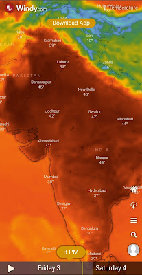
Pic courtesy Shri Hosalikar (IMD)With the heat wave picking up from 4th - 8th, seasonal low in Thar falls to 990...and at TVM remains at 1008, we will have a proper gradient to pull up Monsoon.
7. Monsoon can set over Kerala by 5th/6thJune. Progress expected along West Coast upto Goa by 9th, and into N. Konkan after the 12th (tentatively)...AS A WEAK CURRENT DUE TO REASONS MENTIONED ABOVE.
Mumbai: Pre Monsoon Showers to bring relief from 8th.Proper Monsoon not before 12th June.
Pune: Pre Monsoon showers from 7th june. Relief from heat as day temperatures can fall by 3/4°c
Marathwada & Vidharbh have not much too see except some localised shower pop ups. No sowing to be done till 15th at least.
Goa : Pre Monsoon rain showers from 6th and weak monsoon entering by 9th.
Gujarat: Hot around 40-42c in most regions. Cannot estimate Monsoon date yet. Not before 15th .
मराठवाडा आणि विदर्भ: ७ जून नंतर काही भागात मान्सून पूर्व पावसाची शक्यता आहे, मात्र पेरणी १५ जून पर्यंत तरी करू नये.
Contribution from Vag. Shreyas


2 comments:
Could you explain how the offshore trough formation is linked to winds at 200hpa?
Aakash: There are two articles on the 200 hp jet streams in the Weather Knowledge Page of this blog. Explained there.
This page is full of interesting articles on weather.
Ask again if in doubt.
Post a Comment