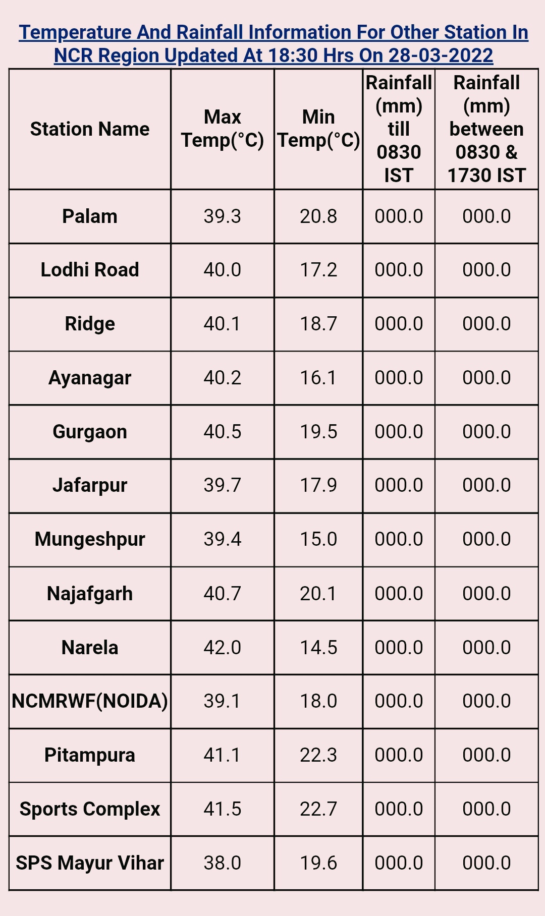
Now Delhi sees the Heat 🔥!!
Some maximum temperatures recorded today from the capital:
Parts of Uttar Pradesh also seeing heatwave like conditions: Agra: 41.1°C
Pune also heats up!!
Shivajinagar, Pune: 39.7°C, highest of the season
Pashan, Pune: 39.8°C
Hot and dry weather likely to prevail over most of Maharashtra, Gujarat, Madhya Pradesh, Rajasthan and northern plains for next 3-4 days.
Pune and Madhya Maharashtra belt likely to see max temperatures of around 40°C, even touching 41°C in some parts.
Interior konkan belt (Palghar, Thane, Raigad, Ratnagiri and Sindhudurg districts) would see max temperature of 40°C or above.
Coastal konkan (including Mumbai) and Goa relatively cooler (35-36°C) with sea breeze.
Compilation by Vagarian Shreyas.


1 comment:
Credit Australian Government Bureau of metereology latest issued 29 03 2022
Issued 29 March 2022
The latest Climate Driver Update and Climate Model Summary are now available on the Bureau's website.
La Niña eases slightly over past fortnight
The 2021–22 La Niña event has weakened slightly in the tropical Pacific over the past fortnight. Climate outlooks indicate a return to neutral El Niño–Southern Oscillation (ENSO) levels—neither La Niña nor El Niño—late in the southern hemisphere autumn. Even as La Niña weakens, it may continue to influence global weather and climate.
Atmospheric and oceanic indicators of ENSO persist at La Niña levels. Sea surface temperatures remain cooler than average along the equator, but have warmed slightly in the east as previously strong trade winds have eased in strength. Other indicators remain at La Niña levels, with decreased cloudiness persisting along the Date Line and a positive Southern Oscillation Index (SOI).
La Niña events increase the likelihood of tropical cyclones within the Australian region, as well as increasing the chances of above average rainfall across large parts of eastern Australia during autumn.
In recent days, the Madden–Julian Oscillation (MJO) entered the Maritime Continent longitudes but has weakened considerably. Climate models indicate the MJO is likely to remain weak, having little influence on tropical weather and climate in the coming fortnight.
The Southern Annular Mode (SAM) index has recently been positive. It is forecast to generally remain neutral over the coming three weeks. A neutral SAM has little influence on Australian climate.
The Indian Ocean Dipole (IOD) is neutral. It typically has little influence on global climate patterns from December to April due to the influence of the monsoon. Outlooks for the IOD indicate a neutral IOD is most likely for the remainder of autumn. Model outlooks have low accuracy beyond this time.
Climate change continues to influence Australian and global climate. Australia's climate has warmed by around 1.47 °C for the 1910–2020 period. Rainfall across northern Australia during its wet season (October–April) has increased since the late 1990s. In recent decades there has been a trend towards a greater proportion of rainfall from high intensity short duration rainfall events, especially across northern Australia.
More information
Media enquiries: (03) 9669 4057 media@bom.gov.au
Next update expected on 12 April 2022
Post a Comment