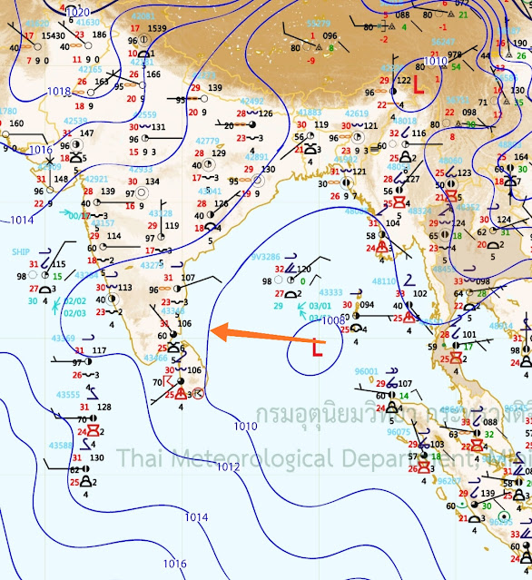
25th October... SWM Withdraws.. & NEM sets in.
(Estimated earlier in Vagaries on 14th)
See (below) complete withdrawal dates from country in last 46 years. Mark the date trend in last 10 years. (IMD)

Tamilnadu, Puducherry & Karaikal: Madurai-11,
Pudukkottai-10, Tiruppur, Toothukudi-8 each, Kodaikanal-4 each;
Interior Karnataka: Kodagu-8, Shivamoga, Mysuru, Dharwad, Mandya-7, Hassan-3;
Kerala: Palakkad-6
Low Pressure now likely to develop in South Bay more and move towards T. N. Coast by 27th.
Effective rainfall will move inland into Karnataka and Southern Madhya Mah. ( Kolhapur, Sangli, Satara) around 1st week November.
Chennai:
Heavy rainfall is expected between 29th and 30th October. Will extend into early November.
Localised flooding, thunderstorm and gale winds is likely, with the monsoon making a good onset.


1 comment:
Credit Australian Government Bureau of metereology latest issued 26 10 2021
Issued 26 October 2021
The latest Climate Driver Update and Climate Model Summary are now available on the Bureau's website.
La Niña ALERT continues—likelihood of La Niña around 70%
ENSO Outlook
Our ENSO Outlook provides
up-to-date information on the likelihood of an El Niño or La Niña developing.
ENSO Outlook dial showing La Niña ALERT status
Current status: La Niña ALERT
The Bureau's ENSO Outlook is at La Niña ALERT. This is due to continued cooling in the tropical Pacific Ocean and climate models showing sustained La Niña conditions over summer. In the past when La Niña ALERT criteria have been met, La Niña has subsequently developed around 70% of the time; this is approximately triple the normal likelihood. La Niña events increase the chances of above-average rainfall for northern and eastern Australia during spring and summer.
Sea surface temperatures in the central tropical Pacific Ocean have cooled over the past three months, edging closer to La Niña levels. These cooler surface waters are supported by cooler than average waters beneath the surface. Some atmospheric indicators, such as the Southern Oscillation Index (SOI) and cloudiness near the Date Line, are approaching La Niña levels. Most international climate models surveyed by the Bureau indicate weak La Niña conditions are likely for the coming months.
The Indian Ocean Dipole (IOD) remains in a negative phase. Models suggest the IOD will return to neutral levels in late spring or early summer. A negative IOD increases the chances of above-average spring rainfall for much of southern and eastern Australia, while a neutral IOD has little influence on Australian climate.
The Madden–Julian Oscillation (MJO) is currently weak or indiscernible. Most models indicate the MJO is likely to remain weak over the coming week to fortnight. When the MJO is weak or indiscernible, it has little influence on tropical climate.
The Southern Annular Mode (SAM) index returned to positive levels over the past week. It is forecast to remain generally at positive levels to the end of the year. A positive SAM during spring typically brings wetter weather to eastern parts of Australia, but drier than average conditions for western Tasmania.
Climate change continues to influence Australian and global climate. Australia's climate has warmed by around 1.44 °C for the 1910–2019 period. Rainfall across northern Australia during its wet season (October–April) has increased since the late 1990s. In recent decades there has been a trend towards a greater proportion of rainfall from high intensity short duration rainfall events, especially across northern Australia.
More information
Media enquiries: (03) 9669 4057 media@bom.gov.au
Next update expected on 9 November 2021
Post a Comment