Posted 6th June 12.30 pm IST
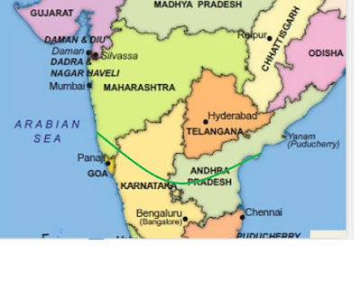
South West Monsoon Enters Goa and South Konkan...6th June.
Now runs from south Konkan thru south Interior Karnataka, south A.P...

With the Upper air circulation (UAC) now restricted to upper levels, and soon move away, the intensity of Thundershowers will reduce over Madhya Maharashtra from Monday. 


Westerly winds expected to strengthen gradually over North Konkan with the speed and depth increasing around middle of the week (9th/10th).
This is when [ 9th/10th] monsoon arrival expected for parts of North Konkan, Mumbai and Pune.
Similar advance into South Gujarat Coastline (Valsad/Surat Districts) on 9th/10th.Bharuch may see Monsoon advance around 11th.
Meanwhile, SWM can enter and commence in the NE States in next 2 days.
Nashik and North Maharashtra may get Thundershowers for another 2-3 days.
[ मराठवाडा / औरंगाबाद - रविवारी हलकी ते मध्यम गडगडाटी वादळ. सोमवार ते शुक्रवार 11 जूनपर्यंत पावसाचे प्रमाण कमी. 15 जूननंतरच योग्य पावसाळा अपेक्षित आहे.शनिवार 12 पर्यंत पेरणीची शिफारस करणार नाही, कारण तोपर्यंत कमी पाऊस पडण्याची शक्यता आहे. शनिवार 12 तारखेला बियाणे पेरणीच्या कामाचा आढावा घेता येईल. (ही वैयक्तिक दृश्ये आहेत आणि कोणताही शेतकरी स्वत: चा निर्णय घेऊ शकतो.)
नागपूर आणि विदर्भ प्रदेश - २- 2-3 दिवस गडगडाटी वादळ. आम्ही 13 जूनच्या सुमारास उपसागरात एक यंत्रणा वर्तविल्यामुळे पुढील आठवड्यात मान्सून वाढू शकतो.]Marathwada/Aurangabad - Light to moderate Thundershowers on Sunday. Decrease in rainfall from Monday till Friday 11th June. Proper Monsoon expected only after 15th June.
Would not recommend sowing till Saturday 12th, as low rainfall is expected till then. Starting of seeds sowing can be reviewed on Saturday 12th. (These are personal views and any farmer may take his own decision.)
Nagpur and Vidarbha region - Thundershowers for 2-3 days. Monsoon possibly can advance next week as we forecast a system in the Bay around 13th June.


1 comment:
Credit Australian Government Bureau of metereology latest issued 08 06 2021
Issued 8 June 2021
The latest Climate Driver Update and Climate Model Summary are now available on the Bureau's website.
Climate drivers currently neutral
The El Niño–Southern Oscillation (ENSO) remains neutral, with all oceanic and atmospheric indicators within the neutral range. Climate model outlooks show this neutral ENSO state is likely to continue until at least spring.
The Indian Ocean Dipole (IOD) is currently neutral, although the index has been below the negative IOD threshold for three consecutive weeks. Large parts of the eastern Indian Ocean are warmer than average, with some cooler than average water near the Horn of Africa. The consensus of international climate model outlooks suggest the IOD is most likely to remain neutral during the first part of winter, although three of the five models suggest negative IOD conditions could develop over winter or spring. The accuracy of IOD forecasts is still low in early June but will increase significantly by the end of the month. A negative IOD increases the chances of above average winter–spring rainfall for parts of southern Australia. While a negative IOD event is not declared until the index remains below the threshold for at least 8 weeks, the current pattern can still influence Australian rainfall as the event evolves.
The Madden–Julian Oscillation (MJO) is currently weak or indiscernible. It is forecast to re-appear over the African region during the next fortnight. Its effect on Australia for this period is expected to be weak. At this time of the year, the MJO influence is primarily in the northern hemisphere, and it therefore has less influence on northern Australia.
The Southern Annular Mode (SAM) has been neutral for the past week. It is expected to be positive for the coming fortnight. Positive SAM typically acts to decrease rainfall over south-west and south-east Australia and increase rainfall over parts of eastern Australia.
Climate change continues to influence Australian and global climate. Australia's climate has warmed by 1.44 ± 0.24 °C over 1910–2019, while southern Australia has seen a reduction of 10–20% in cool season (April–October) rainfall in recent decades.
More information
Media enquiries: (03) 9669 4057 media@bom.gov.au
Next update expected on 22 June 2021
Post a Comment