Co Authors: GSB, Shreyas Dhavale, Pradeep John, Dr. Vineet Singh, Gokul

Monday, November 09, 2015

Posted 10th Night (Tuesday):

Chennai: On Tuesday, Rains intensity decreased as expected. In the 12 hrs ended 8.30 pm IST, Chennai received 24 mms of rain.
Chennai: Still decreasing rains on Tuesday. Meaningfull increase after the arrival of the fresh Low (around 15th).

Bangalore too, was almost as forecasted. As per our estimate, the day's high was 20.4c,with 11 mms of rain in 12 hrs.
Bangalore: Decrease in rains from Tuesday..Day temperature rising. 

BB-10 is now over North TN and adjoining Interior Karnataka. Heavy rains likely in N.I. Karnataka on Wednesday. 
Goa and Coastal Karnataka ( Particularly Karwar coast) may see showers with gusty winds from evening. Light rains in South Konkan.

BB-10 will emerge in the Arabian Sea on Thursday, off Mangalore.

Another Low is forming in the Southern Bay off the Sri Lanka (Eastern) coast around the 13th of November. In all probility, track towards TN coast.


Mumbai was 33.7c  (Colaba) and 35.5c (SCruz) on Tuesday. I expect the nights to cool down by about 2c from Wednesday, and day temperature will remain around 33/34c. Expect more cooling after the 15th, when we may see nights at SCruz falling by 2/3c.

Western Disturbance will precipitate snow on Wednesday and Thursday in the medium and higher reaches of Kashmir and HP and the Northern Most regions of Pakistan.

-----------------------------------------------------------------------------------------------------------------------
Posted Monday 9th Night:
Mumbai will be cloudy on Tuesday, with the day temperatures around 33/34c.
Pune also will be cloudy and easterly winds will keep day around 30/31c.

Depression BB-10 has crossed the East India coast near Pondicherry on Monday evening. On crossing, the pressure as per various estimates was 1002/1004 mb and wind speed estimate 25-27 knts...hence as per IMD terminology, it remains as a Depression.
Depression will track West, and emerge in the Arabian Sea as a Low.

Chennai had good overnight rains amounting to 136 mms at Nungambakkam and 167 mms at Meenambakkam as on Monday morning. during the day, Monday, Meenambakkam measured 44 mms. 
Rains intensity decreasing on Tuesday.

Bangalore was cold and windy as anticipated (see Viayanand's comments) at 21.5c, and received 20 mms till 8.30 pm. 
Tuesday will remain cold and rainy, with the day around 20-22c and around 20 mms of rain.

Western Disturbance N-4 will bring rains to Northern Pakistan regions and Kashmir on Tuesday.
But, it picks up in strength from Wednesday night into Thursday, when, Central Pakistan, that is Upper Sindh, Punjab and Northern regions, And Indian Punjab and Hill States of H.P. and Kashmir get rains and snow.

Sunday, November 08, 2015

Posted Sunday Night: 

As mentioned on Saturday, the Low in the Southern Bay (BB-10) has deepened to depression strength as on Sunday evening, and is tracking towards the Tamil Nadu coast. 

Chennai had a rainy and cool Saturday, with 61 mms from 8.30 am - 8.30 pm. The day was cool at 26.1c. (Minabakkam readings).
As scheduled, Monday will also see rains, maybe around 110-120 mms as estimated. The system will cross the TN coast on Monday night.
Bangalore can get occasional rains on Monday, with around 55-65 mms expected. A cold Monday is estimated with the day around 22/23c.

Mumbai, partly cloudy, will be warm in the day with the temperatures between 33c at Colaba and 34/35c in the suburbs. Evenings will be breezy.

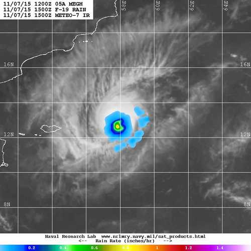
Two Satellite Images of 2 cyclones, 8 days apart in the same location. The observation is the size and strength of both these storms. 
 Chapala...1st November 2015


Megh ....8th November 2015..Looks like a "midget" as termed by JTWC. 
The rain image below shows a very small region of rain..Smaller than a Local Circulation.

Saturday, November 07, 2015

Posted Saturday Night:

The South Bay Low, BB-10, ( 9.1N & 85E) seems to be gaining as expected....currently and about 1006 mb now, and Well Marked, will now deepen and move towards the TN coast.

Chennai will get have a wet Sunday with occasional showers and rains increasing by Sunday night. Monday will be very wet and cool, with around 110-120 mms expected.

See the rain rate compared with BB-10 and AS-3...(Recent)


 "Megh" has strengthened, and now estimated core pressure is an average 990 mb. (See Graph below)
The various agencies differ on the estimate, as the Satellite imagery shows mixed and broken convective banding.. Graph shows the pressure regularly declining gradually last few days.

The core winds estimation is also varying a lot, and differs between 45 knts and 75 knts, averaging 60 knts (110 kmph). (See Graph Below).


Is "Megh" finally a cyclone ?...No...its not...yes it is ....Ok, So, JTWC says... let's call it a "Midget Size Cyclone"....

And this is from Rohit..at usual at his best...See Rohit's Page for Latest.

See Mumbai Page for last 30 days Temperature graphs

Friday, November 06, 2015

Posted Friday 6th Night...Outlook for next 3 days (Weekend):

Mumbai...Warm days at around 34/35c, with hazy skies. evenings can be breezy and providing some comfort. The minimum temperatures in the mornings will be around 22c and 25c (between Scruz and Colaba).

An UAC has formed in the Easterly trough, East off Sri Lanka. This is likely to strengthen and become a surface Low by Friday, and track towards the TN coast this weekend.
Rainfall will gradually increase from Sunday in TN. The coastal regions and Southern peninsula will see heavy rains on Saturday and Sunday. 

Chennai will see an increase in precipitation from Saturday as the system nears the coastline. Very good thunder showers thru Sunday. Would expect around 100- 110 mms from Saturday morning to Monday morning. Could be heavy in some areas of city.

The Well marked Low, or Depression, may cross the TN coast on sunday. Can possibily emerge in the Arabian Sea of Kerala.Could be supported by a current UAC around Lakshadweep Islands.

Expecting heavy showers in Kerala. Idukki region can receive heavy showers this weekend, amounting to around 70-75 mms from Saturday morning to Monday morning.

Kashmir got fairly good rains and snow from N-2, with Gulmarg seeing a day's high of -1.5c and snow.
Well, N-3 could be milder, with precipitation restricted to the most Northern regions of  the sub continent. Northern Pakistan and Kashmir can get rain and snow this weekend, though not substantial. 
Next week N-4 could be stronger and effective.

So, for Delhi NCR, as some clouds rolled in last few days (Mild drizzles), they rolled out also. And the weekend will unfortunately not bring any more rains , or better temperatures.


--------------------------------------------------------------------------------
--------------------------------------------------------------------------------
There is not much mention of AS-3 in Vagaries....That is because it is moving away from the Sub Continent. But Vagaries was not much in favour of this system strengthening beyond the depression stage. 
(The Following are my Personal Views and not binding):Now, if you see this absolutely latest Satellite Image, from no angle does it look like a threatening cyclone. The bands are not defined, the centre is not properly formed/obscured, and the regions of convection are poorly defined. 


The Sat image shows the rain region as quite small , and see the dry air covering...
Anyway, one thing is sure, the dry air has started penetrating into the Western periphery of the system and now is circling from the SW and Southern sides. The western segment is already encountering dry air. The Upper ridge is pushing the system slightly southwards, and the SE section is seeing reduction of moist air incursion. 

The estimated core pressure estimates vary from model and systems of measuring. While the Advanced Dvorak Technique estimates 998 mb, CIRA AMSU: 995 hPa, CIMSS AMSU: 999 hPa, IMD states it as 994 mb and Intensity at T2.5. Winds are estimated between 85-90 kmph, which is good.
In an ordinary angle, today, it looks at the most like a Deep Depression to me.
Situation can change...

More tonight on The upcoming system in North and South...

Thursday, November 05, 2015

Posted Thursday Night:

Rains expected to increase along TN coast (Chennai) and interior TN from Sunday 8th onwards.

1. There is a East -West trough running roughly along the 10N line, eastwards from the East Coast of Sri Lanka. This will embed an UAC and subsequently by the 8th, a Low. .
The Low is expected to deepen and track NW towards the TN Coast. 
 The system can cross the TN coast as a depression by Monday 9th.
There is a slight possibility of system re-emerging in the Arabian Sea off Kerala by mid next week. 

2. Western Disturbance N-3 is likely to bring rains in North Pakistan from Sunday 8th and North India from 9th .
Day and night temperatures are expected to fall in NW and North India next week.
 More on both these systems with weekend forecast on Friday....

AS-3, A depression, at about 1000/1001 mb pressure...monitoring the development as the system tracks West.

Tuesday, November 03, 2015

Posted Wednesday Night:
Srinagar: With 16 mms of rain in the day, the day temperature dropeed to 13.4c on Wednesday. 

Bangalore City is receiving very good rans since last 3 days. With 95 mms flooding the city on Monday,( see Viayanand's comment) there was a reduction yesterday as 7 mms were measured. But, on Wednesday, the showers picked up with 33 mms till 8.30 pm IST. and day temperature at 28.7c.


AS-3 remains a Well Marked Low at estimated pressure at 1004/1006 mb. Seems possible , seeing "not very favourable conditions", it may not deepen much now .


Posted Wednesday Noon (IST):
AS-3 becomes "Well Marked Low Pressure" at estimated 1006 mb..Located at 13N and 67.5E...NRL Sat Image


---------------------------------------------------------------------------------
Posted Tuesday Night:
Mumbai was hot on Tuesday, with the day at 33c in Colaba and 35c at Scruz. Same conditions for next 2 days, maybe more cloudy and stuffy at night.

Panjim , Goa , is now getting some showers on Tuesday evening/Night. 3 mms recorded till 8.30 pm ...Some towns in South Konkan received slightly heavier showers.

Sporadic showers to continue in North Coastal Karnatak, Goa and South Konkan next 2 days.

Weather Situation:
1. The Low expected in the Arabian Sea has formed off the Karnataka Coast. Currently at 1010 mb, it will deepen fast to 1008 mb and then to 1006 mb , and move West.

2. N-1 which had formed and moved East wards across Kashmir, is followed by N-2, and the trough from N-2 may form an induced Low in North-Central Pakistan.
With some rain on Tuesday, the day temperature drops to 16.5c from yesterday's high. With more rains on Wednesday, the day will be colder at around 11-13c.

New Delhi NCR: Same conditions with max around 31c till Friday. Some decrease in day temperatures from Saturday as we see clouds rolling in on the weekend.

Chennai: Showers in many parts of city, could accumulate around 10-15 mms on Wednesday. But, we may see a decrease in rains again from Thursday till Saturday. Normally, I should be estimating more showers and rains for Chennai at this time of the year. But, the momentum is missing.

Sunday, November 01, 2015

Showers expected in Goa & South Konkan on Tuesday 3rd November and Wednesday 4th..

Mumbai again topped to 36.5c at Scruz and 35c at Colaba on Monday.
Mumbai October was hotter than May this year...see averages compiled by Rohit Aroskar
Posted Sunday Night:
Very Severe Cyclone "Chapala" approaching and soon crossing the Southern Coast of Oman and adjoining Yemen. Estimated core pressure 944/950 mb and estimated core winds dangerously high at 195 kmph. 

Mumbai: Monday 2nd Nov and Tuesday 3rd will be sunny and warm. The day temperature which was 35c at Colaba and 36c at Scruz on Sunday. Monday and Tuesday will continue to see above normal temperatures at around 34/35c. Wait for nip in the night continues.

An extremely hot October 2015 for Mumbai...unusual with record highs and record night temperatures...
Mumbai Diagram for October:
1.Diagram shows the average (day and night) temperatures...and the above normal "Red" is seen all through the month.
2. The Second diagram shows the anomaly...The average anomaly was +1.42c above normal.
3. The third diagram shows the actuals..


Goa (Monday /Tuesday) will be partly cloudy with light rains in some regions.

Chennai: Monday and Tuesday can see the thunder shower popping up in parts of the city. Around 10-20 mms per day.
Diagram for Chennai...


And the precipitation deficiency..NEM arrived on 28th October. Total for Chennai in October: AP 159 mms and Chennai 160 mms.
On Sunday, Chennai (Meenabakkam) recorded 45 mms till 8.30 pm IST).

Western Disturbance N-1 approaches Jammu and Kashmir on 2nd/3rd November. Restircted to this Northern State. Srinagar, which has seen a rise in day temperatures to 20c, may see the fall from Tuesday. Wednesday will be rainy.
Another back to back WD, N-2, may follow soon.

8th November : The " Diwali" Air Pollution Chapter Analysis  All India AQI pollution Sectors as on 8th November.. Diwali Day And W...