Weather outlook from Tuesday 21st to Sunday 27th November - Rain returns again for Maharashtra and Gujarat
Somewhat similar to pre-Diwali, another round of rain/thundershowers possible in Maharashtra towards the end of the week!
Mumbai: Rains refuse to subside completely, not allowing winter to set in. The slight pleasant feeling during night/early morning may go away from Thursday 23rd or Friday 24th. Some cloud cover and rising humidity with a chance of some light rain/thundershowers from Friday 24th to Sunday 26th November. Overall cumulative rainfall maybe 10-15 mm for Mumbai region. Days can be warm around 33-34C.
However, Mumbai's AQI can improve after the rain.
Pune: The cooler nights may turn warmer with minimum temperatures rising above 18C from Thursday/Friday. Chance of rain/thundershowers from Friday 24th to Sunday 26th November.
Madhya Maharashtra districts of Solapur, Kolhapur, Sangli, Satara, Pune, Ahmednagar, Nashik, Dhule, Nandurbar, Jalgaon may get some rain/thundershowers from 24th-26th November. Southern districts such as Solapur, Sangli, Kolhapur may also see some showers from Thursday 23rd.
Some areas in Marathwada (Beed, Latur, Dharashiv, Ch. Sambhajinagar, Jalna, Nanded, Washim, Hingoli) and Vidarbha (Akola, Buldhana, Amravati may also see increasing clouds with a chance of some rain.
Konkan and Goa may also get rain/thundershowers during 23rd to 26th.
Gujarat: Rain/thundershowers likely during 25th-27th November for areas in south Gujarat (Surat/Valsad/Bharuch). Saurashtra region may also get some thunderstorms.
Reason for these unseasonal rains...👇
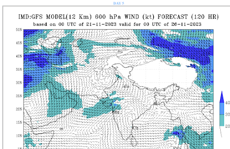
A trough developing in mid-upper level westerlies (600 hPa - 200 hPa) and dropping southwards will lead to increasing divergence ahead/east of the trough axis - unusual for this time of the year.
Moisture will be pushed north into Maharashtra from southerly/southeasterly winds at low levels.
A weak wind convergence/wind discontinuity feature may develop along Ghats of Maharashtra as well, further enhancing cloud formation and thundery developments.
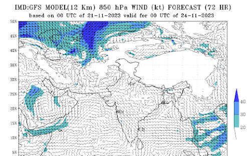

Trough (orange dashed) also seen in the 300 hPa dropping into the Arabian Sea. Region inside yellow boundary can see increased mid-upper level divergence.
More updates by Thursday/Friday if any changes...


No comments:
Post a Comment