Mumbai AQI ..First figure is 2022 avg
Followed by Jan -Oct 2023 ..avg.

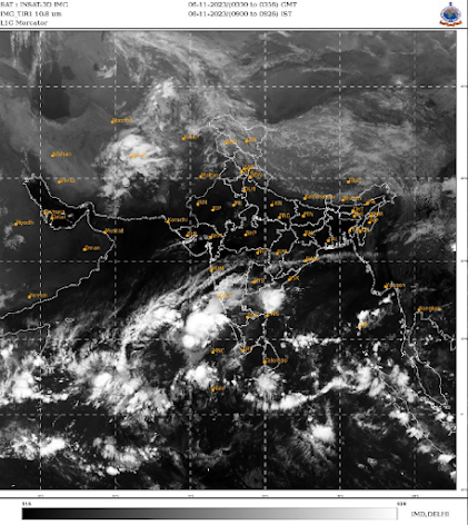
Outlook from Monday 6th till Saturday 11th November:
Rain likely to return for Maharashtra!
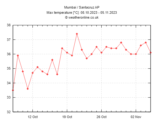
Mumbai: Mumbai continues to manage the over 36c mark for the 20th day at a stretch !
Increasing humidity and discomfort. Chance of some showers/thundershowers in MMR region during Wednesday 8th to Friday 10th November.
Air quality can improve as pollution/haze may reduce by some extent in Mumbai region after rain.
Pune: Increasing cloudiness from Tuesday 7th November. Rain/thundershowers possible from Wednesday 8th to Saturday 11th November. Day temperature may drop a little because of clouds, but night temperatures to increase. No winter feel till Friday/Saturday.
Konkan, Madhya Maharashtra and Goa: Rain/thundershowers possible from today till Saturday 11th November. Intensity and spread of rainfall increases from Tuesday 7th/Wednesday 8th onwards.
Districts such as Ratnagiri, Sindhudurg, Kolhapur, Satara can get some moderate-heavy showers.
Light-Moderate showers also possible in parts of Nashik, Ahmednagar, Sangli, Solapur districts.
Marathwada: Chance of some light rain in Districts of Latur, Dharashiv, Ch. Sambhajinagar, Jalna, Nanded. Few localized areas can see moderate showers.
Interior Karnataka to also get some moderate rain/thundershowers with heavy in few places around Belgaum, Dharwad, Hubli, Vijayapura regions.
Bangalore/Mysore regions to continue getting moderate-heavy rain/thundershowers.
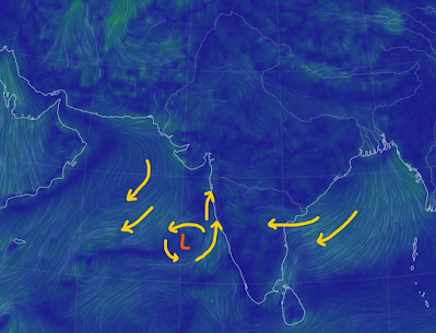
Low pressure area AS-5 likely to develop in the Arabian Sea west of Karnataka coast by 8th November. Moist southerly winds along the west coast will increase humidity and rain chances.
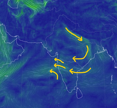
There will also be moisture from southeast winds at 850 hPa, with a weak trough like feature forming over western Maharashtra in the easterlies.


1 comment:
Credit Australian government Bureau of metereology
Issued Wednesday 8 November 2023
The latest Climate Driver Update and Climate Model Summary are now available on our website.
El Niño and positive Indian Ocean Dipole continue
El Niño continues in the tropical Pacific. Climate model forecasts indicate some further warming of the central to eastern Pacific is likely, with SSTs remaining above El Niño thresholds into the early southern hemisphere autumn 2024.
The positive Indian Ocean Dipole (IOD) event persists. All models indicate that this positive IOD will likely continue into early December.
The Southern Annular Mode (SAM) index is currently positive with forecasts indicating it will return to neutral in the coming days.
The Madden–Julian Oscillation (MJO) is currently weak. Approximately half of international climate models suggest the MJO will strengthen and move eastwards across the western Pacific later this week. When the MJO is in the western Pacific, there is an increased chance of showers and rain over northern parts of the NT and Queensland.
Global warming continues to influence Australian and global climate. Global sea surface temperatures (SSTs) were highest on record for their respective months during April to October.
More information
Media liaison (03) 9669 4057
Technical enquiries
helpdesk.climate@bom.gov.au
Next update expected by 21 November 2023
Post a Comment