Rare Red Auroras: See this rare phenomena on Space News Page
Antarctica witnessed world’s most intense heatwave in 2022after temperatures soared 39C above normal...See World Weather News Page
25th September
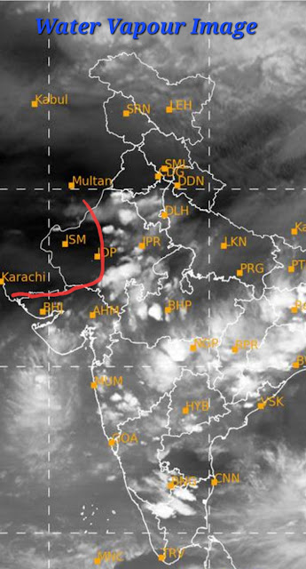
South West Monsoon withdrawal begins from SW Rajasthan as anticyclonic flows/associated ridge persists there .Water Vapour image indicates the Withdrawal
Rains will decrease rapidly over NW India .
A low pressure system embedded in the Monsoon Trough near Vietnam will move west over Bay in the next few days and form a Low in the Bay by 29th.


1 comment:
Credit Australian government Bureau of metereology
Issued Tuesday 26 September 2023
The latest Climate Driver Update and Climate Model Summary are now available on our website.
El Niño and positive Indian Ocean Dipole currently active
An El Niño and a positive Indian Ocean Dipole (IOD) are underway.
Central and eastern Pacific sea surface temperatures (SSTs) continue to exceed El Niño thresholds. Models indicate further warming of the central to eastern Pacific is likely.
Broadscale pressure patterns over the tropical Pacific reflect El Niño, with the 90-day Southern Oscillation Index (SOI) at −10.2. Trade wind strength over the past week has weakened in the far western Pacific, but is close to normal elsewhere.
ENSO Outlook
Our ENSO Outlook provides
up-to-date information on the likelihood of an El Niño or La Niña developing.
Current status: El Niño
Climate models indicate this El Niño is likely to persist until at least the end of February. El Niño typically leads to reduced spring and early summer rainfall for eastern Australia, and warmer days for the southern two-thirds of the country.
The IOD index is +1.45 °C for the week ending 25 September. This is its sixth week above the positive IOD threshold (+0.40 °C). All models predict this positive IOD will persist to at least the end of spring. A positive IOD typically leads to reduced spring rainfall for central and south-east Australia.
The Madden–Julian Oscillation (MJO) is currently weak or indiscernible. All models surveyed indicate the MJO will progress eastwards into the Western Pacific in the coming fortnight; however, half the models suggest it will strengthen, while the other half suggest it will remain weak.
The Southern Annular Mode (SAM) index is currently neutral with forecasts indicating it is likely to remain neutral over the coming fortnight.
The long-range forecast for Australia indicates warmer and drier than average conditions are likely across most of Australia from October to December. The Bureau's climate model takes into account all influences from the oceans and atmosphere when generating its long-range forecasts.
Global warming continues to influence Australian and global climate. Global sea surface temperatures (SSTs) were warmest on record for their respective months during April to August 2023. August 2023 SSTs were also the warmest globally for any month since observational records began in 1850. July and August 2023 were also respectively the hottest and second-hottest months globally in terms of 2-metre air temperature.
More information
Media liaison (03) 9669 4057
Technical enquiries helpdesk.climate@bom.gov.au
Next update expected by 10 October 2023
Post a Comment