Co Authors: GSB, Shreyas Dhavale, Pradeep John, Dr. Vineet Singh, Gokul

Wednesday, January 31, 2018

West Coast got baked with dry heat due to easterlies triggered by HPA sitting over West India.

Mumbai & Ratnagiri in spite being a coastal place, sees just 13% humidity in afternoon time !


Some max temp from the region below for today dated 31st Jan 2018:


Mangalore & Punalur 36.6°C
Ratnagiri & Karwar 36.2°C (4c above normal temp for this time of year)
Mumbai(Colaba) & Mangalore AP 36.0°C
Alibaug 35.8°C (7c above normal temp for this time of year)
Mumbai(Santacruz) 35.8°C (5c above normal temp for this time of year)
Surat & Vengurla 35.6°C
Harnai 35.5°C (7c above normal temp for this time of year)
Dahanu 35.4°C (Today’s Dahanu max equals with the all-time highest record for Jan which was recorded on 17th Jan 1967)
Panaji 35.3°C
Cochin Nedumbassery AP 35.2°C
Honavar 35.0°C

With clear sky and dry weather there is also heat escape in atmosphere by night, so this creates huge difference between min & max temp!

Here are some max & min temp difference below for today dated 31st Jan 2018:

Karjat(AWS) 35.2c/12.2c.. Temp Difference of 23°C
Palghar(AWS) 35.3c/13.7c.. Temp Difference of 21.6°C
Nashik 31c/9.4c.. Temp Difference of 21.6°C
Vengurla 35.6c/14.3c..Temp Difference of 21.3°C
Pune 30.3c/9.6c.. Temp Difference of 20.7°C
Badlapur(private reading) 34.1c/13.5c.. Temp Difference of 20.6°C
Mumbai 35.8c/16.4c.. Temp Difference of 19.4°C
Surat 35.6c/16.4c.. Temp Difference of 19.2°C
Dahanu 35.4c/17.8c.. Temp Difference of 17.6°C
Alibaug 35.8c/18.4c.. Temp Difference of 17.4°C


Tuesday, January 30, 2018

Total Lunar Eclipse on 31st January...Mumbai Viewing/Timing Details...
Click on Link for Count Down to Mumbai Event....
                                                                     
                                                                 Mumbai Timings


On January 31, 2018, the Moon will turn a shade of red in many parts of the World as the Earth moves between the Sun and the Moon, casting its shadow on the Moon's surface.
The Moon does not have any light of its own—it shines because its surface reflects sunlight. During a total lunar eclipse, the Earth moves between the Sun and the Moon and cuts off the Moon's light supply. When this happens, the surface of the Moon takes on a reddish glow instead of going completely dark.The reason why the Moon takes on a reddish colour during totality is a phenomenon called Rayleigh scattering. It is the same mechanism responsible for causing colourful sunrises and sunsets and the sky to look blue.
The red colour of a totally eclipsed Moon has prompted many people in recent years to refer to total lunar eclipses as Blood Moons.


If you look really hard right at the beginning and just before the end of totality, you may detect a light blue or turquoise band on the Moon's face (see image). This happens because the Earth's Ozone layer scatters red light and lets through some of the blue light that is otherwise filtered out by other layers of the atmosphere.

Monday, January 29, 2018

Posted 29th January:


-----------------------------------------------------------------------------------------------

New Find:....

Newest Cloud Types Seen in the Pacific Northwest

In  March 2017, an updated International Cloud Atlas was released and several new clouds were added.

One new cloud is Asperitas, characterized by a complex wave-like base.   This week (January 17th), James Dearman sent me this wonderful shot of an Asperitas cloud that he took near Vancouver, Washington (see below).

Pretty amazing cloud, with undulations looking like a sea surface turned upside down.


Here is another example from Virginia:


These clouds result from wave-like motions in the atmosphere that distort a pre-existing cloud deck.   Such waves can be initiated by fronts, thunderstorms, or some other type of atmospheric disturbance.  Generally no precipitation or severe weather with these clouds--but they do look scary.

Folks normally don't think about it, but the atmosphere is full of waves.    Generally, the atmosphere is stable, meaning if you push an air parcel upward, it will want to return to where it started.  But like a swing set, the air parcel tends to overshoot and goes into an oscillation.  A pendulum is another example.


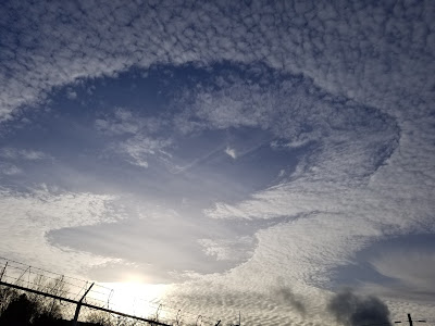
Another new cloud is one we have talked about in this blog:  Cavum, or the hole punch cloud (see below).   These "holes" are produced when an aircraft goes through a cloud made of supercooled water (liquid water below freezing).  The passage of the aircraft through the cloud causes a transition to ice crystals, which subsequently fall out, leaving a hole.

Article Direct from Cliff Mass Weather Blog

Thursday, January 25, 2018

MAHARASHTRA ENJOYING CRISP WINTER .. 25 JAN 2018
THE LONG WEEKEND WILL HAVE ALMOST SIMILAR WEATHER OVER THE STATE

Niphad (Nasik district) has recorded lowest min temp in the state today @ 4.8 c .
North interior Maharashtra experienced sunny,crisp,extremely dry days at 29 c (hum 20%) and chilly nights at 8 c .
The Konkan coast experienced fine,sunny,crisp,dry days at 30 c (hum 30 %) and cool nights at 15 c .
North interior Konkan(Palghar / Thane dist) was in 31 c to 10 c range
In Mumbai region , lowest min temp was recorded at Palghar @ 11.4 c .

(Thanks to Shivkumar for Niphad temp )

Friday, January 19, 2018

Posted 19th January 2018 Night:

U.S. News :
Snow in all 50 states
Snowfall accumulations as far south as the Gulf Coast!

Yesterday morning, all 50 states and 52.3 percent of the country were covered in snow.

To have snow on the ground in all 50 states – at the same time – is fairly rare. The last time that happened was on February 12th, 2010.

A little known fact about Hawaii is that it often snows. Of course, that is always on the Big Island's Mauna Kea volcanic peak. Typically, the hardest state to get accumulating snowfall is Florida. This season has already featured three snowfall events in northern Florida!
Earlier this week, we reported that Russia's remote Yakutia region dropped to minus 88.6 F , -67c. Since then, many questions have come about wondering the coldest temperatures ever recorded in the United States.


When it comes to the coldest temperature ever recorded in the United States, as expected, Alaska takes the crown. The mercury plummeted to -80F, -62.2c,   on January 23, 1971 in Prospect Creek in central Alaska, north of Fairbanks.

By  | 
 

WMTV nbc15.com

Thursday, January 18, 2018

Posted Thursday 18th January Night:

Dry weather expected in the India/Pakistan region till 22nd January.
Delhi NCR will see hazy sun this weekend with temperatures around 25c. Rain expected on Wednesday 23rd.
Mumbai: Clear skies this weekend with days warm around 33-35c. Nights will be around 20c, with no appreciable fall this weekend.
Srinagar will be above normal in the day this weekend, with the day temperatures around 11c. Dry weather this weekend, with Low s around -2c.
With absolutely dry weather in The North, Hill Stations in H.P. Including Simla and in Uttarkahand (Mussoorie etc ) have not received this year's snowfall yet.
Rainfall map of Jan 2018 (Till Date) below


News from U.S.
Great Lakes ice coverage almost triple this date last year
And more than five times what it was on this date in 2016

Great Lakes Ice Coverage

Today, 17 Jan 2018, total ice cover is 35.5%.
On this date a year ago, ice coverage was 13.5%.
And on this date in 2016, it was 6.7%


Monday, January 15, 2018

Posted Monday 15th January:

Very Unusual Weather for January in the Sub Continent....
North-East Monsoon has Ceased and is withdrawn from All over South India from today ...
Manglore again hottest in India at 36.3c, Kottayam (Kerala) 36.2c and Cochin (Kerala) at 36.1c. Hottest place in the Northern Hemisphere on Monday was Kolda (Senegal) at 36.7c...quite close !
Coldest Day in India on Monday 15th was in Gorakhpur (East U.P.) with the mercury not crossing 11.7c. Days will rise by 2/3c from Wednesday, and coldest in the plains was 1.2c at Amritsar.
Leh recorded -10c and Srinagar -3.3c on Monday morning.

No Western Disturbance/ Any Systems expected in the India/Pakistan Region till 22nd January at least...dry weather.
Dry weather in India/Pakistan/Nepal and Bangladesh till 22nd January.


Next Few Days....
Mumbai: This week next few days: Warm around 33c and nights shifting from the pleasant temperatures of last week to 20c.
Pune: Cloudy Tuesday with very light drizzles in some parts. Warm in the day and night. Temperatures drop by 2/3c from Thursday.
Srinagar will be slightly cloudy, with dry weather. Next few days will be in the 13c to -3c range.
Kolkata: Dry weather in the 25c -13c range.
Delhi NCR: Shallow morning fog. In the 25c -8c range.


27th Morning Update brief on Arnab from Vag.Vineet,Mitan Shreyas  Based on JTWC data, Cyclone Arnab intensified by 55knots in 24hrs, this is...