1st December
Sensational News....Mumbai was the Hottest City in Entire Sub Continent on the last day of November!
Mumbai was hottest yesterday because of delay and weak setting of the sea breeze.
Sea breeze, by afternoon, sets in and keeps the temperature under control.
In the case yesterday, East winds from inland dominated the konkan coast.
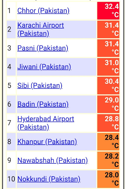
5 out of the ten hottest are from west coast.
India👇
Pakistan 👇


1 comment:
Credit Australian government Bureau of metereology
Issued Tuesday 6 December 2022
The latest Climate Driver Update and Climate Model Summary are now available on our website.
Indian Ocean Dipole returns to neutral; La Niña to continue into summer
The Indian Ocean Dipole (IOD) has returned to neutral. Weekly values of the IOD index have been in the neutral range (between −0.4 °C and +0.4 °C) for five consecutive weeks with the most recent value being −0.16 °C. The ending of the 2022 negative IOD event is consistent with the seasonal cycle of the IOD. The IOD has little influence on Australian climate while the monsoon trough is in the southern hemisphere (typically December to April).
La Niña continues in the tropical Pacific. Atmospheric and oceanic indicators of the El Niño–Southern Oscillation (ENSO) reflect a mature La Niña. Models suggest a return to ENSO-neutral in January or February 2023. During summer, La Niña typically increases the chance of above average rainfall for northern and eastern Australia, and the chance of cooler days and nights for north-east Australia.
The Southern Annular Mode (SAM) is in a weakly positive phase and is likely to be neutral to positive through December. During summer, a positive SAM increases the chance of above average rainfall for parts of eastern Australia and below average rainfall for western Tasmania.
The Madden–Julian Oscillation (MJO) is weak and is expected to remain weak for much of the coming fortnight. Its influence on Australian rainfall over the coming week is expected to be small.
Sea surface temperatures have remained much warmer than average, with waters across the Coral Sea being warmest on record for November and spring. Warmer Australian waters, especially in the tropics, can result in greater evaporation, humidity, cloudiness, and rainfall. Waters in the Great Barrier Reef were warmest on record for November and second-warmest on record for spring, behind only 1998. Warm waters in the Coral Sea and Great Barrier Reef region increase the risk of coral bleaching.
Climate change continues to influence Australian and global climates. Australia's climate has warmed by around 1.47 °C in the period 1910–2021. There has also been a trend towards a greater proportion of rainfall from high intensity short duration rainfall events, especially across northern Australia.
ENSO Outlook
Our ENSO Outlook provides
up-to-date information on the likelihood of an El Niño or La Niña developing
Post a Comment