Forecast for this Weekend, 4th/5th/6th May Up on Current Weather Page.
Do not ctriticise or point fingers at IMD, or any other forecasting agencies...UK Met Office's continued bloomers proves an embarrassment for climate alarmists...See Global Warming Hysteria Page.
Analysis and Discussions on Mw-4 Put up on Inter Active Page of Vagaries:
Monsoon Watch-4. (Part -2).
Very Briefly, explaining the Factors considered for Seasonal Forecast:
If we take into account, that the ENSO will be Neutral, but "leaning" towards a weakish El-Nino phase by, say, end August, then:
a) There will be a drop in the systems originating from the Bay. If at all there will be weak depressions just about reaching Central India and fizzling out.
Hence could result in rainfall deficit for the NW regions, including lower Sindh in Pakistan. Central India and adjoining areas will be well covered.
b) In such a scenario, even the 200 hps jet streams would bend slightly Southwards, and the "low" at that level will be dislodged. could bring in the odd WD even in July. Could bring some heavy rainfall to Upper Pakistan regions. Hence, rainfall could be normal/excess in rest Northern Pakistan and Kashmir. Though technically they will be Monsoon rains.
c) Due to systems reluctant to track southwards, we may see lesser rains in the Southern Peninsula regions. Even the support to the west coast (South of Mumbai)may be lesser than normal. Hence, rain shadow regions in TN and interior Karnataka may be slightly deficient. Lesser gradient along the West coast will show lower rainfall in Kerala, specially in June.
d) Break monsoon situations, and winds bringing in moisture from the Bay (diverted to the NW directions) will result in excessive rainfall this season in Nepal, more so the Eastern regions. NE states of India will get continuous feeding from the Bay. (Cherrapunji seems the likely candidate for the poll).
This is a very early estimates based absolutely on the situation as it shows and stands today.
Things, if and when they change (drastically) will be posted and Vagaries readers will be kept well informed, of any variation in the forecast.
June Only Forecast:

Rainfall expected in Major Cities for June 2012:
Mumbai: 550-600 mms
Chennai: 50-60 mms
New Delhi: 50-55 mms
Banglore: 90-110 mms
Pune: 120-130 mms.
Surat: 250-280 mms
These are my personal views, and should be depended upon commercially or otherwise.
Check Inter Active Page for more Monsoon Information
Do not ctriticise or point fingers at IMD, or any other forecasting agencies...UK Met Office's continued bloomers proves an embarrassment for climate alarmists...See Global Warming Hysteria Page.
Analysis and Discussions on Mw-4 Put up on Inter Active Page of Vagaries:

Very Briefly, explaining the Factors considered for Seasonal Forecast:
If we take into account, that the ENSO will be Neutral, but "leaning" towards a weakish El-Nino phase by, say, end August, then:
a) There will be a drop in the systems originating from the Bay. If at all there will be weak depressions just about reaching Central India and fizzling out.
Hence could result in rainfall deficit for the NW regions, including lower Sindh in Pakistan. Central India and adjoining areas will be well covered.
b) In such a scenario, even the 200 hps jet streams would bend slightly Southwards, and the "low" at that level will be dislodged. could bring in the odd WD even in July. Could bring some heavy rainfall to Upper Pakistan regions. Hence, rainfall could be normal/excess in rest Northern Pakistan and Kashmir. Though technically they will be Monsoon rains.
c) Due to systems reluctant to track southwards, we may see lesser rains in the Southern Peninsula regions. Even the support to the west coast (South of Mumbai)may be lesser than normal. Hence, rain shadow regions in TN and interior Karnataka may be slightly deficient. Lesser gradient along the West coast will show lower rainfall in Kerala, specially in June.
d) Break monsoon situations, and winds bringing in moisture from the Bay (diverted to the NW directions) will result in excessive rainfall this season in Nepal, more so the Eastern regions. NE states of India will get continuous feeding from the Bay. (Cherrapunji seems the likely candidate for the poll).
This is a very early estimates based absolutely on the situation as it shows and stands today.
Things, if and when they change (drastically) will be posted and Vagaries readers will be kept well informed, of any variation in the forecast.
June Only Forecast:

Rainfall expected in Major Cities for June 2012:
Mumbai: 550-600 mms
Chennai: 50-60 mms
New Delhi: 50-55 mms
Banglore: 90-110 mms
Pune: 120-130 mms.
Surat: 250-280 mms
These are my personal views, and should be depended upon commercially or otherwise.
Check Inter Active Page for more Monsoon Information


20 comments:
Thanks Rajesh, its pretty much in line what most models have indicated. (will not be surpised if negative IOD and weak El Nino strikes a killer blow to 2012 monsoon) In all proabbaility we are set for a drought in South, west and north west region. Plenty of rains in North east (which does not really help anyone). Double whammy for India with over exploitation of ground water and gradual decrease in monsoon
Regards, Ananth
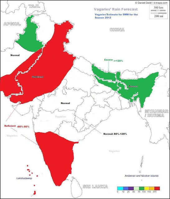
Hi Rajesh!. From this forecast map it does look that around 30% of the country will receive below average rains.
The forecasted excess rainfall areas maybe around 10%.
This would leave less than 60% of the country with normal rainfall.
With such a geographic rainfall distribution, the overall mean rainfall should slip into the deficient category viz below 90% of LPA.
Is this the correct reading?
Hi Ananth.
First of all, can I have the link to your inter-active blog. Readers here talk highly of the blog.
Now to your comment:
"if negative IOD and weak El Nino strikes a killer blow to 2012 monsoon)"
My first comment is at the moment it looks an extremely WEAK IOD too.
Secondly, I borrowed a technique from Piers Corbyn, he checks back the past to see what similar parameters did then.
So before I made my forecast, I checked up all years where an IOD and El Nino superimposed themselves. I could find just 1930 when it happened and as such this year could be the only second time such a phenomenon can happen, if at all. But I could be wrong and I ask one and all do the same research for a confirmation.
So what did I find in 1930?
Rainfall: 831.5 viz. around 93% of LPA.
Now I do not know the values of IOD and El Nino in 1930 but considering that both the events are extremely weak, I took the gamble of predicting a normal monsoon.
Of course, the methodology could be rubbished but Piers Corbyn swears by it and has a success rate of 80%
I like to hear what all of you think.
Dear Rajan,
I do not have any blog of my own, i just realised that SSET erroneously attributed one of Rajesh's analysis as my own (i just realised that now, I hope Rajesh would not mind me taking some of his credit !! ). i am just an amateur reader, i have been following your blog in the last few weeks and your knowledge is exemplary.
To your observation, I suppose a negative IOD and EL Nino are kind of mutually exclusive events (i will try to get some data to support this hypothesis) ,I will be glad if any of our fellow readers(who have better expertise) could pitch in on this. In view of this your observations and analysis does make sense. I will share if i am able to find any data to support my vague hypothesis.
Thank you,
Regards, Ananth
Thanx Ananth for your speedy reply.
SSET. I did go to your profile the other day and to your one post blog. Your comments are very incisive and I encourage you to re-activate your blog.
I am also very much an amateur too though I was told my blog gives a very different impression. I am sorry about that!
Weather forecasting is a very hazardous industry. Being chaotic, there are too many variables and things changing all the time. When we consider one set of parameters, some others maybe more critical.
Its by trying to ride the learning curve we gradually master something. That's what I try to do by blogging.
I believe that as amateurs if we apply our mind and start accumulating some knowledge, we too can contribute our mite to the forecasting industry.
And thnx
Rajan/Ananth: Reply and views put up on Inter active page for common reading by all.
Dear Rajesh,
Wonderful graphical analysis.
North Tamil Nadu seems to be on wetter side during SWM last few years. Taking that into consideration. Chennai should cross 100 mm rainfall in June this year too.
Chennai's June rainfall in last 5 years
2011 - 130 mm
2010 - 137 mm
2009 - 23 mm
2008 - 125 mm
2007 - 94 mm
As you said Kerala will have reduced rainfall. Will it applicable to Andhra Pradesh too. I think my personal view is andhra this year will be on the normal or excess side.
Pradeep: Your answer on inter-active Page -:))
Thnx Rajesh. I too am beginning to feel the probability of a below average monsoon is increasing. On the face of it, the IMD forecast looks very balance.
What is clear is that rainfall distribution should be very unbalanced this year which in turn will adversely agriculture.
Hi Rajesh,
Core pressure at Jaisalmer at 2 30 PM today stood at 999.2, i hope the next WD does not disturb the heating to a major extent.
Regards, Ananth
wanted to ask...is bay preparing to host a low again???
Hello- For all people who love MATHEMATICS!!! Weather models are based on QUANT models. Usually predictive analytics are used with timeseries data. AutoRegression with Moving averages, least squares, k-means clusters are some of the statistical techniques.
Wish all happy rains - ofcourse nothing like Mumbai 24/7 Rains - typically we will not see SUN from June-September.
If we go by Rajesh estimates
june -600mm
july - 1200mm
august - 1200mm
september-600mm
Mumbai cool can expect nothing less than 3600mm (in range 3500-4000mm)
Disappointed south again less rains - AP/KAR drought is a serious concern - Bangalore is now blazing hot - looks like heat wave of AP is sweeping in???
Thanks
KK in "India weather blog" has mentioned about emergence of lakes in Thar desert/Rajisthan/Gujarat as one of the reasons for no heat waves in NW regions. This is attributed to plenty of SWM rains since last 5 years. We may see dissappearence of deserts. Meanwhile AP is boiling 45degrees at Rentachala. This may move to 50s soon. Bangalore close proximity to Rayalseema - is getting hotter, drier.
By the way Ananth/Rajan - what is IOD? Any good link which explains weather terminologies?
Thanks
sset: your calculations and estimates are over enthusiastic.
I said, for june 550-600mms. No other monthwise forecast. and annual will be around normal; taht is 2250 mms for Mumbai. even + 20% would be 2700 mms at the most.
BTW, the norma of normal etc are taken as per IMD.
OK Rajesh sir - we stand by your side. June I am winding up my work at Bangalore (where I have not seen any rain since last 1 year) to Navi Mumbai - full of hills /waterfalls/greenary. Kharghar is comparable to scotland- series of cascading waterfalls. AS rain ends by october - take toy train to Matheran.
@rajesh hws ur vacations going???i dont understand why r we experiencing muggy weather in mumbai ,,the mininmum at night is in the range of 27-28!!while ratnagiri at 22.8 and panjim at 24.5?????why the minimum of west coast above mumbai is high!!also clouding is increasing day by day!!cloudy skies in the morning give way to partly cloudy conditions
junaid: Thanks..vacationing and learning the weather from well versed meteorologists.
Mumbai has to get muggy and stuffy now. Its not unusual. In fact there will be clouding daily now, till the pre monsoon showers arrive. I think i have put up the dates.
Next MW-5 on wednesday will be put up.
Sset if u luk into geographical distbn of indian regns then the int kar/west central ap and central parts of mah r in thorn forest whch s driest part of india evn n comparisn with eastrn rajasthan
and regardng the heatwave as evn rajesh sr has also said it is minimum ths year and temperature in parts of telangana reaches 47 to 49 deg during ths time f d year
and for int karnataka(excluding bangalore) and int tamilnadu and certain parts of rayalseema i persönly thnk the premonsoon in april was quite good
Post a Comment