Co Authors: GSB, Shreyas Dhavale, Pradeep John, Dr. Vineet Singh, Gokul
Sunday, July 31, 2022
The popular Monsoon Analysis by GSB will be put up here at 11.30 pm IST
India recorded 327.7mm rain in july which is 16.9% above normal. In terms of actual rain this is the wettest July after 2005, in terms of percentage departure from normal this is the highest positive percentage departure from normal after 1994
Compiled by vag.Vineet
Seasonal Rainfall
Mawsynram 6238 mms
Cherrapunjee 6233 mms
Goa July Rains
Friday, July 29, 2022
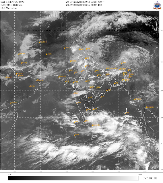
Weekend forecast till Sunday 31st July:
Monsoon active over northern regions of India, chance of patchy thundershowers in Maharashtra!
Mumbai: Next few days, relief for commuters as Mumbai continues to get only passing showers. Warm and humid daytime, with a shower or two likely for this weekend.
मुंबई: पुढचे काही दिवस पाऊस कमी असेल. दिवसातून १-२ पावसाच्या सरी पडू शकतील, व दिवसा बराच वेळ सूर्यप्रकाश असेल. दिवसा थोडा उकाडा देखील जाणवेल.
Pune: Warm and humid daytime. Chance of rain/Thundershowers in parts of the district during afternoon/evening today and tomorrow. Isolated areas can get localized heavy rain.
Aurangabad: Warm days...some chance of light rain/thundershowers in parts of the district, not evenly distributed.
औरंगाबाद जिल्हा: दिवसा वातावरण थोडे गरम राहील. आज व उद्या काही भागात हलका पाऊस/गडगडाटी पाऊस पडू शकेल. पावसाचे प्रमाण सर्व ठिकाणी समान नसेल.
Madhya Maharashtra and Marathwada districts of Pune, Satara, Sangli, Kolhapur, Solapur, Ahmednagar, Nanded, Osmanabad, Beed, Parbhani could get patchy rain/Thundershowers today and tomorrow. Chance of rain decreasing from Sunday.
Himalayan regions of Jammu, Kashmir, Ladakh, Himachal Pradesh and Uttarakhand likely to get moderate rain with heavy in some regions for next 2 days. Avoid travel unless necessary.
Monsoon trough over northern plains, closer to Himalayas.
Wednesday, July 27, 2022
New Development in Meteorology: Now Categorizing and naming Heat Waves
‘Zoe’ Becomes the World’s First Named Heat Wave
Blistering temperatures ranked as a Category 3—the most severe tier—in Seville, Spain’s new heat wave system
The world’s first named heat wave hit Seville, Spain, this week, pushing temperatures past 110 degrees Fahrenheit and earning the most severe tier in the city’s new heat wave ranking system.
Heat wave “Zoe” has brought scorching temperatures to the southern part of the country for the last few days, particularly the region of Andalusia where Seville is located. Even in the evenings, the Spanish meteorological service recorded temperatures that hovered in the mid-80s in some areas — an extra stress on the human body, which relies on cooler nights to recover from high daytime heat.
Zoe is the first named heat wave to hit Seville since it officially launched a new pilot program last month for naming and ranking heat waves, similar to hurricanes (Climatewire, June 22). Only the most severe heat waves get names, designated this year in reverse alphabetical order. After Zoe, comes Yago, Xenia, Wenceslao and Vega.
The program is a collaboration between the city of Seville and the Atlantic Council’s Adrienne Arsht-Rockefeller Foundation Resilience Center (Arsht-Rock), with other partners including the Spanish Office for Climate Change and several Spanish universities and research institutes. It takes a three-tiered approach to categorizing heat waves in Seville, with Category 1 as the lowest ranking and Category 3 as the most severe.
The system has specific criteria for each category, involving not only daytime temperatures, but also nighttime lows, humidity and the heat’s expected effects on human health.
Each tier triggers a set of emergency response services, like issuing weather alerts, opening cooling centers and dispatching community health teams to check on vulnerable populations.
Spain has been grappling with extreme temperatures for much of the summer already. High heat broke local records around the country last month, and the first two weeks of June were the hottest on record in the country, according to the Spanish meteorological service.
Outlook for the next 4 days from Monday 25th - 28th July:
It's all about the shifting of the Monsoon trough..from extreme North, 8 days ago bringing rainfall in the Northern States to shifting South bringing rainfall to Rajasthan, Gujarat & Sindh last weekend. Now, from Tuesday 26th, a gradual Northern movement commences...from Wednesday 27th, gradually decreasing rains in Maharashtra, Gujarat, M.P. &Rajasthan....while increased rainfall in Delhi , Haryana. West U.P. and Uttarakhand and H.P.
Delhi : 25th/26th not much change...
Wednesday Rainfall increases from 27th...Temperatures dropping tp 30/31°
Mumbai: Passing showers on Monday &Tuesday.
Wednesday: 27th..Decrease in rainfall with sunny intervals. Around 31°
Pune: Pleasant week with light drizzles. Upto 5 to 7 mms rain/day. Around 28-29C.
Aurangabad &Marathwada: Monday 25th &Tuesday 26th, With few Passing showers, the crops will remain well watered.
Wednesday onwards decreasing rains. Maybe sunny.
Gujarat Region & Bharuch: Monday 25th &Tuesday 26th, Gujarat region will get fairly good rainfall.
Wednesday 27th onwards a sharp decreasing trend in rain and temperatures rising.
Sindh &,Balochistan received good rains. Rains can persist to a lesser extent in Sindh (Karachi) next 2 days. May reduce after that.
Rainfall of Rajasthan as on Sunday Morning
Rains in Gujarat last 24 hrs ended 24th Morning 👇
Saturday, July 23, 2022
Continuing , now the scene goes to Kutch and a Sindh
Rapar Kutch, 92 mms on Saturday evening ..6pm to 8pm. ...👇
Video courtesy Vag Gaurav Raninga ( Junagadh)
Bachau Kutch 52 mms...6 to 8 Saturday
And Sunday Jodhpur as told..Sunday afternoon 👇
23rd..July
Rains in Rajasthan last 24hrs
Kota 109 mms
Baean 60
Jaipur 89 mms
Bundi &Ramganj 55 mms
Jhalawar 55 mms
Churu 33 mms
Jaipur water-logging
Friday, July 22, 2022
22nd July....
The Monsoon Axis in normal position now, rains expected in Rajasthan on 22nd and 23rd..Good rains Jaipur expected.
But, increased rains expected in West Rajasthan (Jodhpur 40 mms or more) on Sunday 24th.
24th, axis moves South and creates an embedded low around Sindh.
Heavy rain expected in Kutch and moderate to heavy in Saurashtra on Sunday 24th & 25th Monday.
Heavy rainfall expected in Sindh. Including Karachi. Karachi can expect rains exceeding 100 mms cumulative on Sunday & Monday(As of now).
Mumbai sees a moderate increase in 🌧 rainfall on Saturday (evening) and Sunday 24th.
Pune too will see more frequent rain 🌧 on Sunday 24th.
With westerlies weakening, Thundershowers likely to continue for Bangalore and south interior Karnataka as well as Tamil Nadu