Co Authors: GSB, Shreyas Dhavale, Pradeep John, Dr. Vineet Singh, Gokul

Friday, October 07, 2022

Weather scenario for Weekend 8th October to 13th October 

Rainy weather for north and west India!

Rainfall likely in east Gujarat (Ahmedabad, Gandhinagar, Vadodara, Bharuch regions) and parts of south and east


Rajasthan tonight and tomorrow.


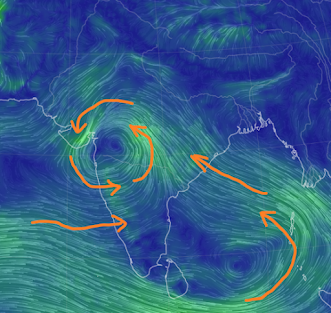
A cyclonic circulation seen at 850 hPa over north Maharashtra causing moisture inflow from Arabian Sea, resulting in rains and delaying SWM withdrawal. 

850 hPa winds 


Moisture from this is pulled north and northeast by the winds at 500 hPa and above, bringing rain to north India. 
500 hPa winds
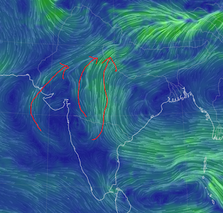

Moderate rain likely over Delhi and NCR region and across Uttar Pradesh till Sunday. Some places to receive heavy rain. Cool and pleasant weather for likely this weekend. 

Interaction with an incoming Western Disturbance (WD) will cause heavy rains across Uttarakhand and Nepal till Monday 10th October. 
Fresh snow over upper reaches is likely. Since weather is not cold enough like winters, chances of avalanches remain after this round of snow. 

Mumbai & Pune 
The presence of moisture and combined effects of this UAC and incoming WD will result in humid weather with chances of rain across Mumbai and Pune for next few days. 

Monsoon withdrawal may not happen before 15th October.
 
Further updates as things evolve. 


7th October Evening 6pm.

The thundershowers in Mumbai today is not unusual or alarming.  

As the movement of the low pressure system BB 14, moved across Central India, it has activated rainfall in Mumbai and Gujarat.


This resulted with an interaction with a Western Disturbance trough from North India. Hence the thunder.

This system activation was expected, and Monsoon Withdrawal date declaration held back ( see previous post).

Showers in South Mumbai and Suburbs 

Figures from 2pm to 6pm Compiled by Vag Tejas 

Cooper hosp 49mm in last 4 hrs

Versova pumping station 61mm

Jogeshwari rly station 47mm

Ram mandir 37mm

DN road municipal head office 68mm

Sobo  higher than suburbs

Mumbai MMR, Pune and Nashik district can receive thunder showers ..chance of rain/thundershowers persists over the weekend.

Mumbai Monsoon can persist into next week 

Wednesday, October 05, 2022

 October 5th..

Dussehra wishes to all Vagaries Readers 

It now seems we may have to neglect the weak BB 14 and concentrate on this new Low..fresh development. 

This may now alter SWM dates, and adhere to originally mentioned SWM withdrawal dates.


Tuesday, October 04, 2022

 NASA scientists are studying the latest satellite imagery of the storm and analyzing the forces that made the storm so catastrophic.

Very Good Images and Explanation here. (Also on World Weather News Page)

Monday, October 03, 2022

October 3rd:

South West Monsoon over in Gujarat, Rajasthan, Haryana, Punjab, J & K, H.P, and Delhi.


Next withdrawal phase around 7th/9th from North Maharashtra, West M.P.

Sunday, October 02, 2022

Posted on 2nd October Evening:

Mumbai: The last 3 days of the Navratri celebrations...and how is the weather going to play along ?

Hold on Monsoon still lingering.

This week ( 3rd Monday to 6th Thursday), Mumbai will see partly cloudy skies. But a few moderate (and sharp intense) thundershowers are likely. Rainfall around 10-25 mms/day  variation expected. Occurrence of the showers would be in localised in different areas of city. Possibility of an evening shower on Dussehra holds good.

Pune: also can see some light to moderate showers in the late afternoons. expected rainfall in parts of city around 5-10 mms.

For both cities, we hold on the further Forecast, as a dim chance of rain continuing into weekend holds good.

Marathwada & Vidharbh will get light to moderate rainfall this week 3rd onwards. Around 10 mms/day. Few places rain may exceed 20-30 mms/day from 5th Wednesday

Farmers are advised to cover the crops if already cut and removed for storage. As wet conditions may spoil the cut crops.

या आठवड्यात  मराठवाडाआणि विदर्भ  हलका ते मध्यम पाऊस पडेल. सुमारे 10 मिमी/दिवस. शेतकरी आधीच कापलेली आणि साठवणीसाठी काढलेली पिके झाकून ठेवू शकतात. ओल्या परिस्थितीमुळे कापलेली पिके खराब होऊ शकतात. काही ठिकाणी बुधवार 5 ऑक्टोबर पासून 20-30 मिमी/दिवस पेक्षा जास्त पाऊस असू शकतो.

-----------------------------------------------------------------------------------------------------------------------------

BB-14 moving towards the UAC, and could merge as explained earlier.


But, its further movement after crossing the A.P./Odisha coast should be NW.

Interacting with W.D, there will be  some rains in Central India, Bihar, U.P. Uttarakhand (East)and .Affecting upto Nepal..

We expect possibly some post Monsoon showers in Delhi this weekend.

Keeping in mind the above scenario, we hold on to the withdrawal line for a few more days.

  Vagaries Climate Change : Pros and Cons blog updated with Global Warming is Causing Cold Spells See Non Weather Matter Page Updated  Wing...