Monsoon Watch - 1..2024:
These reports are the views, study and observations of Vagaries. Estimates and forecasts are also the calculation of Vagaries, and may/may not tally with any other estimates. This may not be used for commercial purposes. Vagaries of Weather is not responsible for any commercial loss from this article, or these series of articles.
The Monsoon developments, as they unfold, will be analysed and discussed and explained in Vagaries.
The South West Monsoon is just about 35 days away from its normal date of arrival from the shores of India ! Yes ! its just 35 days from the First touch of shores...Southern most point of India on the South Andaman Islands, Indira Point, where the normal arrival date is 15th May.
And its about time we start the follow up of its progress and monitor its developments.
This annual series is a follow up and chasing of the South-West Monsoon.
Every article in this series explains the synoptic situation as it actually is, and based on the day's position, the date and quantum of rains as per THIS SITUATION.
It is very important to firstly estimate the date of arrival of the South West Monsoon, as year to year, variations in dates of onset of the monsoon can occur and there have been several occasions in the past when the monsoon arrived over certain parts of the country about a fortnight earlier or later than the normal dates. The SWM has the weatherman tearing😒at his hair for the exact date or time, extent and progress. This is never 100 per cent sure though various weather national / international models are used to calculate this event.
Initially, this series will be chasing and closely following up the actual developments of the monsoon parameters, and analysing its progress for calculating and estimating the arrival date.
We are not yet contemplating the quantum of rains or the monsoon strength as yet.
1. The Mascrene High, the power House of te S.W. Monsoon, still in the nascent stage.
2023 showed almost similar High at 1033
So, no question of the proper cross equatorial winds developing yet.
2.ENSO:
El Niño continues and is near its end. Climate models indicate sea surface temperatures in the central tropical Pacific are expected to return to ENSO-neutral later in 2024.
Transition from El Niño to ENSO-neutral is likely by April-June 2024 (83% chance), with increasing odds of La Niña developing in June-August 2024 (62% chance).
Inference: Chances of a good Monsoon.
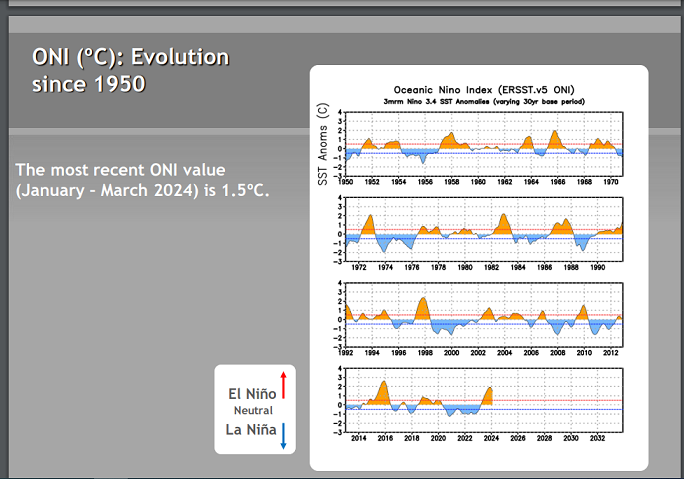
3.Oceanic Niño Index (ONI)
NOAA Operational Definitions for El Niño and La Niña
El Niño: characterized by a positive ONI greater than or equal to +0.5ºC.
La Niña: characterized by a negative ONI less than or equal to -0.5ºC
3. March Observations:

Inference: Too early to spot the Seasonal Lows...Awaiting the Heat Waves.
Monsoon Estimates: Seems to be Normal Monsoon....Arrival date cannot be estimated yet.
Next MW -2 on 21st April.


1 comment:
Thanks Rajesh, i look forward to this monsoon watch.... very very informative..
Post a Comment