Monsoon Watch - 8
Cross Equatorial Flow has picked up considerably in the Arabian Sea. Winds over 30-35 knts are seen gushing Northwards off the Somali Coast.
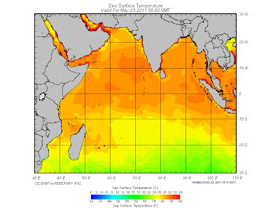
Today's SST map is reproduced here to show the Sea temperature falling along the Somali coast. It is presently around 26c. Now, this difference with the Central Arabian Sea plays a key role in cloud formations in the Central Arabian Seas. The SST along the Somali coast will rapidly fall to around 18/20c in the next 15 days.
But the current fall is sufficient to help form Monsoon clouds off the Maldives. Cloud formation near Maldives is gathering, and in next 24 hrs, wind speed along the Maldives coast is estimated at 40 mph as per the country's Met Dept.
The ITCZ has moved up a bit and is now around the 3N region south of India, and in the 5N region in the Bay sector.
SWM should set in over the Maldives within next 36 hrs, that is by the 25th/26th May. Further advance into the Sri Lanka coast is possible around 26th/27th.
The Seasonal Low seems to have got punctured. With the M3 creating an undesirable situation, we see today's pressure at 1000 mb. Not enough to create a gradient to pull up SW winds into the mainland. The day temperatures on the SubContinent Northern plains have dropped since Saturday, and restricted the day's highs to around 40c. Across in Pakistan' Sindh region, the core for the formation of the low, the highest was 47c on Monday.
M3 HAS become the "kill joy" we had NOT hoped for !
M4 is seen on the horizon, and will be into Pak/India Northern regions from 26th May. Rainfall increasing into Nepal from 27th May.
The Bay sector has been unusually weak. Its lack of systems could be attributed to M3. Strong westerly currents prevent the formation of lows to move into the bay and towards the Indian mainland. They divert the forming currents.
As SW winds should pick up speed in the next 2 days, SWM "in situ", could advance into the bay Islands as a weak current on the 26th of May.
Better before the M4 reaches the region to spoil another "party".
Conclusion: SWM advancing into Maldives by 25th (late by 5 days) and Sri Lanka by the 26th of May (late by 2 days). Similarly, SWM moving into Bay Islands by the 26th of May.(Late by 5 days).
Advance into Kerala around expected date , 3rd/4th June. But, further advance needs monitoring. Formation of a system in the Arabian Sea possible in the first week of June.


6 comments:
one question here..shouldn't the monsoon have reached andaman islands by now??or has it already reached??
BOB ITCZ should read as 5N (It's a Typo)
is this a reliable source for sst and and general weather conditions at the sea? (i.e. when one selects one ship or bouy for that info)
thanks
Hi Rajesh,
what could be the potential impact of super cyclone Songda in your prediction. will it suck away all the moisture or will help a pulse formation in BoB ?
Thanks, Ananth
u did predict that a system may form in first week of june in arabian sea.Now my question is whether the system will intensify into cyclone?
Yes, many forecast model predicting tropical activity in arabian sea in 1st week of june. If i am right we could now have 4 cyclones in a row in first week of june for last 4 years striking oman. Hopefully it just a depression & move toward west coast if not then monsoon could arrive late in mumbai.
Post a Comment