27th February:
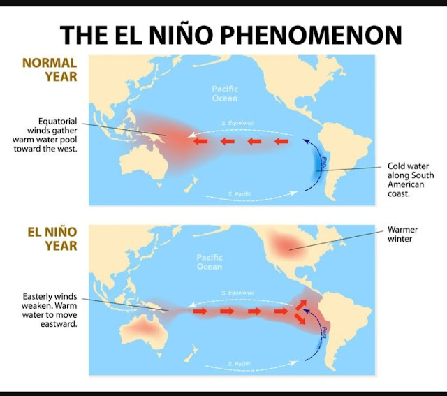
We have been hearing recent voices upon a El Nino condition possible in the Indian Monsoon Months.
(El Nino is the phenomena that reduces rainfall in the Monsoon Months).
Well, let me clarify, it is still early to jump to a conclusion..that "El Nino will spoil the Indian Summer Monsoon this year ". It is not realistc today to come to any conclusions regarding El Nino.
There are no definite and clear indications, that, surely El Nino conditions will prevail over our region in June/July.
The current status of this (Called ENSO Conditions) do not clearly show it...
Now, lets see what the Latest NOAA adversary study shows about the current scenario..
>La Niña is present.
( La Nina is the reverse of El Nino.)
>Equatorial sea surface temperatures (SSTs) are below average across most of the Pacific Ocean.
>The tropical Pacific atmosphere is consistent with La Niña.
>'Negative SST anomalies have gradually
weakened across most of the
equatorial Pacific Ocean since at least
December 2022 and positive SST
anomalies have emerged in the far
eastern equatorial Pacific Ocean since
late January 2023.''
>also,..The latest weekly
SST departures are:
Niño 4 -0.6ºC
Niño 3.4 -0.5ºC
*Upper-level (200-hPa) westerly wind anomalies were observed across the central and east-central equatorial Pacific, with anomalous cyclones on either side of the equator.
ENSO-neutral conditions* are expected to begin within the next couple of months, and persist through the Northern Hemisphere spring and early summer....(meaning May to July..early Monsoon).
Early conditions do not warranty any panic or concern for Monsoon..
* Neutral Conditions means neither La Nina nor El Nino.


3 comments:
thanks Rajesh...this explanation was needed..
Credit Australian government Bureau of metereology
Issued Tuesday 28 February 2023
The latest Climate Driver Update and Climate Model Summary are now available on our website.
La Niña likely near its end
La Niña has weakened in the tropical Pacific Ocean and is likely near its end. Ocean indicators of La Niña have returned to neutral levels, while atmospheric indicators that remain at La Niña levels have started to weaken.
All but one of the surveyed international climate models suggest sea surface temperatures in the tropical Pacific (including NINO3.4) will remain neutral (neither El Niño nor La Niña) through autumn; one model is neutral in March and April but touches on El Niño thresholds in May. ENSO outlooks extending beyond autumn should be viewed with caution as models typically have lower forecast accuracy at this time of year.
The Madden–Julian Oscillation (MJO) is forecast to strengthen over the western Pacific at the start of March and then move to the central then eastern Pacific over the coming fortnight. This may contribute to monsoonal and cloudy conditions over far northern Australia over the coming week, but drier conditions are expected as the MJO moves further east. Westerly wind anomalies associated with the MJO may also weaken the trade winds in the tropical Pacific, contributing to the further breakdown of La Niña.
The Southern Annular Mode (SAM) index is currently positive, but is expected to return to neutral values over the coming weeks.
Warmer than average sea surface temperatures persist around south-east Australia, New Zealand and the west coast of Australia, but have returned to close to average temperatures in waters to Australia's north.
Climate change continues to influence Australian and global climates. Australia's climate has warmed by around 1.47 °C over the period 1910–2021. There has also been a trend towards a greater proportion of rainfall from high intensity short duration rainfall events, especially across northern Australia. Southern Australia has seen a reduction of 10 to 20% in cool season (April–October) rainfall in recent decades.
More information
Media liaison (03) 9669 4057
Technical enquiries
helpdesk.climate@bom.gov.au
Next update expected by 14 March 202
Any chances for rains in Maharashtra for first half of March ?
Post a Comment