A Low may form off the Orissa /AP coast by Sunday, 10th June, and move swiftly inland to fizzle out in 24 hrs.
This may result in some rather heavy rainfall in the coastal regions of AP , mainly South of Vizag on Monday.
Meanwhile, this low will whip up some anti clock-wise winds and resultantly, bring strong Westerlies to the TN region. Critically located is Chennai for strongish west winds, which may bring in a sharp rise in the day temperature in Chennai to 40c on Monday/Tuesday.
Sunday 10th.>

Monday 11th>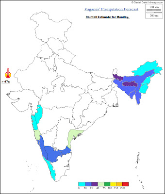

Tuesday 12th>

The SWM will be pulled up on the Eastern coast covering TN and AP, and to some extent interior Karnataka by Monday, 11th June.
On the West Coast, the SWM could possibly pull up into South Konkan on Monday, 11th, where rainfall will be upto 5-7 cms in some stations.
I see moisture "drying up" from Monday in the western areas of interior Mah (Pune, Panvel, and the Lonavala, Matheran and Mahableshwar regions), with possible decrease in rainfall Monday/Tuesday.
The gradient along the western front has reduced, and as the pressure rises, the off shore trough weakens.
Mumbai: Some towering cumulus clouds were seen in the Eastern and Northern skies of Mumbai on Saturday.

Panvel could have a shower or two.

Panvel will be warm and cloudy, more sunny than Sunday. Brief passing shower.

Panvel could only have a light passsing shower.
Pune : Sunday/Monday/Tuesday: Cloudy, with sunny intervals. Days will be warm (35/36c) and stuffy. Brief passing light showers in some parts.


12 comments:
junaid:junaid: Seeing your comments, i went thru some serious efforts to get the rain figures for Panvel. You were abs correct..The figures were corrected subsequently, and the real rainfall till Saturday morning for Panvel is 54.6 mms with 31 mms last 24 hrs...total of June as yet. You made me do some engineering..-:))
@rajesh actually i wish the pleasant clime prevailing in panvel soon extends to south mumbai!!ths year thngs turned very diffrently here ,thye start of the wet season was without any thunderstorm and the rain falling from nowwhere(no towering clouds etc)typical monsoonal clouds coming from south west ,,!!!ANYWAYS rajesh i have always been confused abt one fact,,how do imd or u connect the monsoon advance line to tamil nadu!!since it is a rain shadow area wat all criteria u guys take in account??
@rajesh actually i wish the pleasant clime prevailing in panvel soon extends to south mumbai!!ths year thngs turned very diffrently here ,thye start of the wet season was without any thunderstorm and the rain falling from nowwhere(no towering clouds etc)typical monsoonal clouds coming from south west ,,!!!ANYWAYS rajesh i have always been confused abt one fact,,how do imd or u connect the monsoon advance line to tamil nadu!!since it is a rain shadow area wat all criteria u guys take in account??
Hi Rajesh, Is there any chance of cyclone in Arabian sea this year? bcoz its quite calm as compare to the previous years in the month of June please comment.
junaid: Different parametetrs are reffered to for seperate regions while advancing Monsoon. I refer to several parameters, which are exhaustively expalined in my MW series'. Like for TN I would see the OLR, 200 hpa jets, prevailing winds, UTH , the pressure and the gradient, wind shera or the 850 hpa set up, and the CAPE differences.
UKhan: As yet, today I see no development of any cyclone in the Arabian Sea this month. Maybe, they can form in october again. a system like a depression or low can form in this season. Will keep informed of any.
Rajesh as you predicted, clouds over BB are moving towards Orissa and AP. Will AP get normal rains? AP in grip of drought (2 years) and intense heat wave this year any rain is blessing of GOD(NATURE). This year intial phase of monsoon quickly moved up in west coast and did not cover AP, interior KAR and TN - probably this system over BAY should help? OR system will quickly move over north west and form depression/UAC over Rajisthan/Kutch?
Pavan and others - weather analysis needs study of all parameters and perform statistical correlations - needs weather domain understanding. Except experts like Rajesh, we all look only at satellite picture.
I wont be surprised if IMD declares monsoon over Mumbai tomorrow. Since morning Dadar had four 20 mins steady showers, my eastimate is that we had upto 20mm rains today. Any site where I can confirm rain figure? MCGM site not updating it.
sset: No sset, no one is an expert.We all are still in the learning stage, and with the weather, everybody is learning always.
Like I said, AP coast and parts of interior should get good rains , for a couple of days. This low will last only max of 36 hrs and merge in the trough.
But heat wave can reduce.
SWM has moved into S konkan and int karn,as I have put up on the Flash News just now..
svt:You will get current readings only from the weather stations..try.
You will find the South Mumbai (Mahalaxmi area) updated on Vagaries page "Mumbai Readings @Vagaries' station". If thats ok with you, I update it frequently in the day.
Below the daily readings, you will see a small blue print showing the current days latest rainfall upto a certain time..like it is updated by me at 5 pm Sunday..these readings are as per my rain guage.. if thats ok.
Thanks. So Mahalaxmi got 16.8mm of rains till 5 pm. Clouds were also came from south-west, not from east. Can we now declare that monsoon has arrived in Mumbai?
panvel rainfal:- 2 cm fr 24 hrs0830 hrs sunday morning ,,that translate to 74 mm of rain total for june:):):):)
@sset i do kno frm whr u r, but whn evr u cmt u tel only abt drought in ap and int kar, and int heatwave in ap and these regns r gng to be desert and thar and kutch r getng greenr ok i agree with ur point, i hope u vist ths blog once in a fortngt with same question and if u want to really see hw expert mr rajesh is then pls go throuh ths blog frm 20th april i want to clarify tht mr rajesh s nt making hs points n seeing the sat image
Post a Comment