Sunday, September 30, 2012


Short Narration:
Monday 1st/Tuesday 2nd: The heaviest rains are in Madhya Maharashtra, Marathwada, North Interior Karnataka and North AP. 
South Konkan/Goa and coastal Karnataka gets moderate rains as shown.
Pune is expected to get heavy thunderstorms in the evenings. Hyderabad may get the thundershower too.

Wednesday: SWM withdraws from North Maharashtra, North Chattisgarh and Nepal. 
Good rainfall in south Maharashtra, South Konkan/Goa, and adjoining AP.

Mumbai City:
Monday/Tuesday: Partly cloudy in the day. Thundery conditions in the evening, with thunderclouds drifting in from the East. possible heavy spell in some areas.

Outer towns inland can also expect thundershowers in the afternoon/evening. Heavy spells in some regions. 

Wednesday: Clear day with thundery developments in the evening. Thunderheads over the Eastern inland towns  regions, where some thundershowers possible.

SWM withdraw from Mumbai and Pune, rest of Maharashtra and North Karnataka on Friday 5th October.


x--------------------------------x-------------------------------x--------------------------x----------x-x


BB7 moves slightly West, and on Sunday morning was situated at 84E and 15.5N. And was at 1006 mb. Satellite image of 06.30Z  depicts the centre very clearly and prominently.

UAC in the Arabian Sea has descended to a lower level and is off the Goa/Karnataka coast.
Trough aloft connecting these 2 systems has strengthened as both are still "alive" and active. Clouding seen in Peninsula is due to the trough.
Clouding below the axis down into South peninsula is seen along the "line of dis-continuity".

The "Region A" , an area "created" by vagaries to depict the inter-action region where the monsoon axis and the wind dis-continuity vertical line meet is now covering Maharashtra.

Mumbai: From 12.15 pm Sunday, Small cumulus clouds, are popping up in the East and can be seen "pinkish" tints...pressure in the morning was 1009 mb today...

Saturday, September 29, 2012


Huge Thunderstorm South Of Mumbai..@5.30pm Pic on Inter active page of this blog, and many more on Vagaries fb 


Posting @ 1.30pm Saturday...
A Vortex at 700 hpa seems to be forming off the TN coast...If it forms, it may form in the Southward trough from BB7.....we'll have to follow the movements of these 3 systems surrounding the Southern Peninsula very very closely....shall keep vagaries informed , and please keep vagaries informed also....

Curiosity Rover Report (Sept. 28, 2012) Mars Streambed..A River Ran Through It: Why Do They Think There Was Once Water on Mars?

Friday, September 28, 2012

The Synoptic Situation as on Friday Evening shown on Super Imposed on IMD Satellite Image (below) for easy reference. The trough shown is an Upper Air Trough. 

Follow up with last blog...(The UAC off the west coast forecasted by (only)Vagaries has been announced by IMD today-:)).

Now, everything on schedule. I expect the SWM to slide down Maharashtra by Monday, and get stuck over Karnataka.


Thursday, September 27, 2012


The Low in the bay has moved N, and is now located at 15N and 88E.It is now numbered BB7. 

Corresponding clouding with the system is seen in the West of BB7.

Vagaries expects BB7 to track N/NE, and remain at the current 1004 mb strength.

Coming back to the Indian region, now that the Monsoon has withdrawn from the Northern state, and Western MP, we see the projected vertical line of wind dis-continuity running Southwards from Maharashtra down Southwards. 

As explained earlier, the winds to the North of our "Region A" (now formed. Reason i had requested to go thru the previous blog. To understand "Region A"), and turning NW South of region A. See here.
This is causing the turbulence in the Upper atmosphere, and instability at medium levels.
A string of thunder activity is seen Southwards from interior Maharashtra thru interior Karnataka.
This position remains status quo till Sunday, hence interior Maharashtra and Karnataka thunderstorm activity gradually increases this week end. (for Mah: Pune /Mahableshwar/Kolhapur/Solapur).

Meanwhile, another UAC forecasted (only) by Vagaries off the Karnataka coast is expected to form by Saturday. Saturday sees very heavy rains along the Karnataka coast due to this system.

Subsequently, this off shore UAC and  the  weakened BB7,  as an UAC, form a horizontal trough, roughly running thru Karnataka.
Heavy rains in Karnataka Saturday and Sunday. I repeat, Bangalore gets heavy rains this weekend....


This weekend, Monsoon further withdraws from South Gujarat, MP and Vidharbha. Hence, "limping rains" in Vidharbha.

Dry for Delhi NCR, with days hot at 35c, and nights dropping slightly to 21c by Sunday morning.

Mumbai: 
Though we did spot prominent "dotted' alto cumulus clouds on Thursday, the sky was not yet "blue enough", and was a bit hazy.
Due to inland developments close to Mumbai, favourable chances of a couple of thunderstorms drifting in from the East till Sunday


Thursday morning review of several inernational isobar charts show that a Low has formed in the Bay as on 5.30am Thursday. 
The position of the Low drawn from various charts show the centre of the low (1008 mb) around 12N and 88E. The clouding segment thus arrived at is in the S/SW of the low.
One model (NGP) predicts its movement towards the Orissa coast.

The SW Monsoon has withdrawn from North Gujarat, Northern MP, West UP and HP. 
Western Nepal has no more of the SW Monsoon current now.

Resultantly, the seasonal low which was dominating the movemnet of the monsoon axis , is "wiped out" and the Sindh/Rajasthan and Northern Indian regions is under a High pressure at 1012 mb. 
Expecting Northerly winds to commence in the withdrawn areas.

Wednesday, September 26, 2012

The withdrawal line of SWM moves South.
The Bay UAC has moved a bit to the SE, but not yet descended to sea levels.

Moisture drawn from the  TN and Karnataka regions is being drawn towards the system, resulting in some thunderstorms along the route in TN and Pondicherry today (Wednesday) evening.

And for Maharashtra, vagaries had mentioned : Direct Quote from Yesterday's blog:: " Thundershowers will be trying to "pop up" in Maharashtra on Wed 26th/Thursday 27th/Friday 28th/Saturday 29th, as the monsoon current weakens fast over the state."
Today, few thundershowers have commenced from the Vidharbha and Satara regions. Lets see tomorrow.

And guys , For Mumbai,  what was said was :Direct Quote: "Two or Three thunderstorms at the most, between Wednesday and Sunday." 
Patience is the Virtue which few Enjoy,  
we still have another 4 days to look forward to..after all otherwise, without a break, how can 2/3 storms occur in 5 days -

Thundercloud pic from South Mumbai on Wednesday..interactive Page..and many other thundercloud formations from various readers on vagaries fb page..
Further Withdrwawal of SWM from Rajasthan, Haryana, Kashmir, Delhi, HP, Utteranchal and West UP Tuesday, 26th night...Daily UTH,OLR and winds confirm.

Now for the next phase of axis moving towards N.Mah to trigger the thunder activity (see prevoius blog) and further retreats from regions    "alloted" by Vagaries for Friday seems to be on schedule. ( including Nepal) .


Sticky mini vortex mentioned brings the Saurashtra and Eastern Gujarat rains, with Surat getting 36 mms and Amreli 16 mms.  Another 2 days, and Monsoon withdraws ! 

But, unexpectedly, vortex moving west into Kutch and SE Sindh..light rains there ??

Bay UAC maintains position, and may drop to sea level to form a low today. Then track away from coast.

Mumbai pressure rises to 1014 mb today, highest since end April ! Now look out for towering cumulus clouds till Sunday...

Monday, September 24, 2012


Retreating SW Monsoon:

The anticyclone over Rajasthan and adjoining regions has all  but  dis-integrated  the seasonal low, and with a vengence, is all set to "wipe it off"  from the Western region by Friday. 
The seasonal low, if we can now call it so, over the Rajasthan region is 1004 mb, and soon will be a huge region of "high" at 1010 mb. 

Favourable conditions will withdraw SWM out of Rajasthan, Haryana, Kashmir, Delhi, HP, Utteranchal and West UP by Wednesday 26th.

The axis moves towards Northern Maharashtra by Thursday, 27th/Friday 28th, and the SWM is all set to call it a "season" from Gujarat, MP and UP by Friday 28th.

Resultantly, once the above scenario takes shape, the Westerlies winds in the NW and Northern India will become N/NW, and will cover all of Northern and Central India, down South upto the Vidharbha region. 


These Northerly winds, will change direction South of the Monsoon axis over Maharashtra. 
For convienance, I'll call this region "Region A", where the North winds cease and line of dis-continuity starts, and where the axis will be located. 

Now, South of this, the axis line diverts the wind, and in the State of Karnataka, a line of wind dis-continuity can form, creating turbulent weather.

Please note, that this "Region A" may occur slightly North or South of Vidharbha, cannot be too sure today.

Rains anywhere? 

As the anticyclone grips the Northern and Central States, the winds go "haywire" and turn a drastic Northerly in Northern and Central India upto Vidarbha.

Thundershowers will be trying to "pop up" in Maharashtra on Wed 26th/Thursday 27th/Friday 28th/Saturday 29th, as the monsoon current weakens fast over the state.

A sticky local mini vortex aloft brings some rains to Saurashtra and Eastern Gujarat Tuesday 25th/Wednesday 26th. 
A weak Low forms in the Bay on Wednesday 26th, and rapidly moves into Jharkhand/W.Bengal (Heavy rains).

Mumbai: For many of Vagaries' Mumbai readers, it will be a short lived monsoon farewell (compared to what we have seen last few years). Two or Three thunderstorms at the most, between Wednesday and Sunday.

SWM retreat will be somewhat "stuck" for some time after retreating upto Karnataka.

Immiedietly, on the withdrawal line reaching coastal Karnataka, the shortened "pigmy" off shore trough strengthens, and the strong "diverted " inland winds may give rise to an UAC/Low off the Karnataka Coast by Saturday 29th, and heavy rains likely in coastal Karnataka Saturday 29th/Sunday 30th.(Again, since this is a long term estimate, the UAC/Low may form a bit North or South).

Thats not all ! The rainfall moves eastwards into Karnataka, and even Bangalore can expect heavy rains for a couple of days early next week.

So, the SWM will not move away from the Southern Indian Peninsula till mid week next, at least. 

Presuming it retreats after the 5th of October, NEM can be, in calculable probibilities, NEM can start its advance between 16th October and 20th October...as of the situation today.


btw, IMD annonced Monsoon withdrawal from extreme west Rajasthan and Kashmir....on 24th, as hinted by vagaries a few days ago..


Saturday, September 22, 2012

San Francisco Fog seen via satellite and my personal experience (and pics) of this beautiful event..a treat for any met man..see International Page 
Fantastic Rare pics..

Curiosity Captures a Martian Eclipse...on Space News Page. Dont miss this unique event

GSB with the Latest rainfall analysis: On Inter Active Page..


Vagaries considers the SW Monsoon as having withdrawn from Western Rajasthan, Punjab and Kashmir as on Saturday, 22nd September.
(IMD will withdraw SWM from these regions on 24th)


Friday, September 21, 2012


SWM Withdrawal Watch:

1. We can presume the core of the seasonal low, the main factor "fulcrum" of the monsoon axis has started vanishing. Latest map shows a very weak elongated low over the Balochistan region at 1004 mb.

2. The prevailing anti-cyclone over Sindh has "elongated" and extended westwards into the Westren Rajasthan region. Low humidity and clear skies are prevailing there and the UTH has also extended its grip North-Westwards today (Friday).


3.Corresponding OLR readings of over 300 w/m2 are seen in the Kutch and Rajasthan regions.


4. 200 hpa jet streams have steaied themselves above the 30N line.

Vagaries will withdraw (and make corresponding announcement) the SWM from Rest of Pakistan, Western Rajasthan, Punjab, Haryana and Kashmir on Saturday, 22nd September.
(*Withdrawal is announced after the parameters are established, and 90% of the region recieves no rain).
But, by IMD standards, for withdrawal, there has to be no rain in these regions for 5 continuous days, hence the official withdrawal from them will come later. 

Saturday, 22nd/Sunday 23rd: 

There will be "triggered" storms in Interior Maharashtra and Northern Karnataka. Gujarat, barring Kutch, will get rainfall in some areas, including Gujarat region (Eastern) and Saurashtra.
Surat, Ahmadabad, Baroda, Surat and Bharuch can get showers. 

Heavy thundershowers possible in pockets of Marathwada, Vidarbha and Madhya Maharashtra.
Rainfall also possible in South MP (Indore), and extreme South Rajasthan adjoining Gujarat.

A trough runs along the East coast of India, from the UAC over Orissa, embedded in the axis. Will result in heavy rains in Orissa, Coastal AP, parts of Interior AP, and Northern regions of TN coast. 
Chennai will get the odd thundershower "popping up" on the weekend. The trough shows a reasonable "dent" along the southern AP/TN coast on the week end. Possible heavy localised showers in some parts including Chennai.

Mumbai:
Saturday/Sunday: Cloudy morning, with rain in some areas. Getting clear by late morning. Clouds re-grouping by afternoon. Thunderclouds developing by evening, with heavy thundershowers possible. 

Pune: 
Saturday/Sunday: Partly cloudy, with thunery developments from afternoon. Thundershowers, heavy in certain parts, possible.   

Delhi NCR: Few clouds. Day temperature will be around 33/34c, and nights will be at a low of 24c. SW Monsoon withdrawal in next phase after Haryana*. 

Kathmandu may get a light thundershower, with clouds developing over the ranges. But, rainfall decreases after Sunday. Currently the temperature range will be between 30-18c, but nights will drop from Monday by 2c. 


Cherrapunji Annual Total crosses 12000 mms, at 12150 mms till 21st september 2012....


Wednesday, September 19, 2012

Posted on Thursday, 20th..@ 10.30pm

Monsoon axis slides South and is running thru Rajasthan, North MP and Jharkhand...Hence NW winds prevalent North of the axis. Anti-Cyclone at 850 hpa takes grip over Sindh, and expected to widen its grip Westwards next 2 days.

Hastens up Monsoon Withdrawal ..? Lets wait and see....meanwhile, this will surely "rev" up the Gujarat and Interior Maharashtra thunderstorms..on schedule for Friday as mentioned below in Yesterday's post..

Abhijit has put up pics of Thundery Developments in Pune..See Inter Active Page..

Parameters on the Wednesday evening chart coincide with the withdrawal of the SW Monsoon from complete Sindh region of Pakistan. 

Setting the tone, the SWM is likely to retreat from rest of Pakistan and Western Rajasthan in the next 2 days, that is by Saturday, 22nd, evening.

Thursday, 20th/Friday, 21st: 
Heavy thundershowers on the increase in all regions of interior Maharastra, i.e. Madhya Maharashtra, Marathwada and Vidharbha. 
Pune, Satara, Sangli, Nasik and ghat staions can possibly get thundershowers Friday. 
Nagpur can get convective rains. 
N.I.Karnataka will also get isolated thundershowers in some pockets. Northern AP can get thundershowers, with likely rain in Hyderabad

Very light rainfall, with thunder, likely in few districts of Saurashtra. Surat and Bharuch districts can get a stray thundershower on Friday evening.

NW India, and Delhi NCR will be clear and dry, with days reaching 34c, and night around 24c. SW Monsoon has not withdrawn from NCR and may retreat middle of next week.

Mumbai: 
Thursday: Warm Day, with day temperature touching 32c. Night will be 25c on Thursday morning. Sunny, getting cloudy post noon. Thunder clouds will be forming around 50-70 kms in SE/E/Ne of Mumbai.


Friday: Early morning clouds may precipitate light showers in some parts. Clearing soon by morning itself. Hot day at 32/33c, with thunderclouds forming about 40-50 kms SE/E/NE of Mumbai. Thunderstorm in townships in these areas. 
A thundercell may drift towards Mumbai bringing some brief showers in some Northern/Eastern suburbs. 

Pune: 
Thursday: Warm day at 30c, and nights around 19/20c. Thursday will see thundery developments by evening. 
Friday evening may see a thundershower in some parts.

Posted Wednesday@ 10.30pm

Tuesday, September 18, 2012


SW Monsoon Withdrawal Watch and Indicators:...posted on Tuesday @10.30pm

Seasonal Low pressure over Sindh Pakistan rises to 1004 mb, and weak anti-cyclone formation seen over the region.
Substantial drop in water vapour and humidity levels seen from satellite images over the Sindh region. 
UTH also shows a progressive drop. 
By tomorrow, we can expect an anti-cyclone, that is high pressure area to form at 850 hpa level over Central Sindh region. 
200 jet streams are yet flowing from the SE into the NW regions of the sub-continent.

Vagaries expects the SWM to retreat from South/Central and Upper Sindh regions of Pakistan from Morning Thursday,20th September.

The WD has moved away from the Indian Sub-Continent. Hence, the regions under its influence shall see a drastic decrease in rainfall. 
Pahalgam and Gulmarg in Kashmir saw heavy rains amounting to 48 mms and 39 mms bringing down the night low to 4.5c in Gulmarg.

Meanwhile, it may be recalled, that vagaries had predicted an UAC from the Bay to move N/NE due to this WD. Well, the UAC has crossed Orissa coast, and as expected, moved North into Jharkhand as on Tuesday evening. Heavy rainfall is expected in the region, but the system weakens fast.

The west coast trough has weakened even further, and shows negligible prominence.

General Forecast for Mon/Tue/Wed is going well as per schedule, and remains unchanged.

Mumbai:
Presuming the withdrawal progresses as per the normal routine from Wednesday, starting from Sindh, we can expect Thundershowers in Mumbai from 25th September, and withdrawal process moves "normally", we can expect the monsoon to withdraw from Mumbai around 10th October.


Pradeep's Rainfall toppers as on 15th September are are a bit late and is being compiled....Shall be on Vagaries by 20th Morning..

City Report as on 4.30 pm Tuesday:

New Delhi is cloudy with light rains in the afternoon, with the high at 30c. GK2 private station measured just about 1 mm till 4 pm.

Mumbai, Vagaries station recorded a high of 32c today...hot and stuffy, with very few clouds.

Kathmandu:  Light drizzles in the day with just about 2 mms in the day. But a late afternoon drizzle brought the temperature down to 19c from a high of 23c in the day. 

Karachi is cloudy in parts with the day stuffy and hot at 35c..

Monday, September 17, 2012

Maharashtra: Isolated Thunder showers likely Tuesday, 18th,  in Marathwada and west Vidarbha (evening)


Recent Heavy Rains in Sindh...a Satellite overview..See on International Page Updated today......


Monday saw the mentioned WD active in the Northern regions of the Sub-Continent.


On the Indian side, Kashmir and Punjab recieved good rains with Amritsar measuring 19 mms. Delhi NCR saw Noida getting 19 mms today Gurgaon 7 mmsand Indrapuram 16 mms. 

Gulmarg in Kashmir got 22 mms with the temperature at 9c. 

On Monday, he higher reaches of the ranges in HP received snowfall. Kasauli measured 71 mms in the day (Monday), Mandi 10 mms, Kufri 8 mms and Hill Station Dalhousie 6 mms with the day's hight at 14c. 


Northern regions of Pakistan got very good rains (as per yesterday's forecast) with the capital Islamabad measuring between 75-115 mms of rain. Lahore got 85 mms in the last 24 hrs till Monday evening, and several other places recieved between 15-40 mms. Hill Staion Muree got 52 mms till evening. Muree had a high of 19c today.
Islamabad was a cool 25c in the day Monday. 

Kathmandu too recieved 44 mms rain on a wet Monday. Day long rains kept day's high at 20.5c with the overnight low at 19.5c. The sharpest showers were at around 1 pm. The day's total at Thankot was 56 mms and Babarmahal 39 mms till evening.(neeraj sends his report in the comments).

Sunday, September 16, 2012


Current Weather Scenario as on Sunday 16th, Night:

Monsoon Axis: Very much North into the Himalayan foothills. Runs from absolute Northern Punjab (Pakistan), thru Indian Punjab, hugging the UP/Nepal border and then going SE via W.Bengal into the Bay.A trough aloft at 850 hpa runs from Utteranchal thru Nepal to Himalayan W.Bengal.
The West coast off shore trough is weak and unorganized.

Observations of SWM withdrawal Indicators: The seasonal low "core" in Sindh is expected to rise to a minimum level of 1000 mb from the current 998 mb. 
The core is seen getting weaker. The UTH is also seen as diminishing in Sindh region. (See  below)
Westerly jet streams picking up around 30N line.


Weather Forecast for Monday, 17th/Tuesday, 18th/Wednesday, 19th: 

The west coast trough remains weak. The East coast trough,on the other hand strengthens a bit and moves closer to the North AP/Tamil Nadu coast.

And, on Tuesday, or Wednesday, an UAC can form in the Northern Bay. Unlike normal Monsoon situation, this UAC should move inland into Orissa, and subsequently move N/NW into Jharkhand and adjoining Bengal.
Reason ? A WD , will be moving across the Kashmir and HP states on Monday thru Tuesday.

Rainfall for Monday, 17th/Tuesday, 18th/Wednesday, 19th: 

Of-course heavy in Kashmir and HP, and Northern UP. Northern most regions of Pakistan can get heavy rains. 
Moderate rains in Punjab (Pakistan and India). Moderate rains in Utteranhal. 

For Delhi NCR, moderate thunder and rainfall (between 10-30 mms) in most of the regions, on Tuesday 18th and Wednesday, 19th. 

Nepal gets continues good rainfall till Tuesday, and decreasing from Wednesday. Again, Sunday Kathmandu saw another 31 mms, taking the September total to 418 mms.

UAC brings heavy rainfall on Tuesday into Orissa and Jharkand.

Tuesday/Wednesday could bring some showers to Nagpur.

Monsoon remains weak over the Gujarat, west coast and interior Maharashtra and Karnataka. 

Thundershowers likely to pop up around the Southern coastal AP and adjoining coastal TamilNadu.

Mumbai: 
Monday/Tuesday: Sunny with cloudy intervals. Couple of showers in some parts, with rain amount 7-10 mms. Day warm at 31c.
Wednesday morning will be misty in the suburbs and outer areas. Day remains sunny with partly cloud covered sky in the evening. A shower possible . Day wil be warm at 31c.

Pune: Monday/Tuesday/Wednesday: Partly cloudy days, with light rain in some selected areas. wednesday will be dry. Misty mornings on Tuesday and wednesday. Warm in the day time around 30c. 


Weekly analysis from GSB on Inter Active Page...Please see


Friday, September 14, 2012


As on Friday evening, the Monsoon axis is nestled in the Himalayan foothills, running thru from Pakistan Punjab in the west thru North UP and then thru North Bengal into the Bay.

Saturday/Sunday: Resultantly, rainfall will occur in Pakistan Punjab, Indian Punjab and Haryana, Delhi NCR, North UP and in Nepal. 
Hill states of HP and Utteranchal will also continue to get heavy rains. Heavy rainfall in Himalayan Bengal, Sikkim and Meghalaya.
Rainfall will be weak in Gujarat, Central India, West coast (including Konkan) and Southern Peninsula.

Mumbai City: 
Saturday,15th: After Friday overnight moderate rains, Saturday will become Partly cloudy with sunny intervals. A couple of showers , brief but heavy in some parts. Rain amount: 15 mms.

Sunday, 16th: Warm Sunny day. Day around 30/31c. Passing clouds will result in a few showers amounting to 10 mms.

Pune: Saturday/Sunday: Days progessively getting cloudy by evening. Light rains in some parts. Nights could drop to 19/20c.

Weather Analysis:

SST drops 0.1c in Nino 4 !The Oceanic Nino Index is still hovering around 0.1c. 

{El Niño: characterized by a positive ONI greater than or equal to +0.5°C.
La Niña: characterized by a negative ONI less than or equal to  -0.5°C.
By historical standards, to be classified as a full-fledged El Niño or La Niña episode, these thresholds must be exceeded for a period of at least 5 consecutive overlapping 3-month seasons}.

So, we have Neutral ENSO conditions, supported by neutral value SOI. Soi latest value is +0.8.

On the MJO front, an active wave is now moving towards the East. The MJO in our seas will see a weak phase from the 15th of September, as the current OLR charts show of the scene already getting weak in the sub-continent and moving East rapidly.

From next week, we keep a watch on the signs, if any, for the SWM withdrawal. Initially, we start , by keeping a watch on the Western Rajasthan and Sindh region of Pakistan. 

Track the pressure over the region, currently at 998 mb, For that is the first sign of the seasonal low weakening. We also keep track on the day and night temperatures in that region, for the days will riase corresponding with a fall in night temperatures. And of-course the daily rainfall.

On the charts, we observe and see if an anti-cyclone develops in the region. 
These are some of the indications to keep an eye on (besides many others), as these will give us the pointers to the withdrawal commencment. There are no indications yet !

My estimate is that the withdrawal (from Sindh) would commence around Thursday, 20th September.  

Thursday, September 13, 2012

Mars Is Earthlike As It Might Look, But Cold to the Bone !!..See Fantastic Pic and Mars Weather write up on Space News Page

Well, my last put up forecast period ended on Thursday. 

I'll start with my most sucessfull region, Kathmandu. The capital recieved very heavy rains from Thursday, amounting to 135 mms in 24 hrs ended Thursday evening. this could be the highest 24 hr rainfall ever for the month of September, i'll check up on that. The month's total with today's rainfall goes upto 299 mms, against a September normal of 200 mms for Kathmandu. Wasn't "rainfall increasing on Thursday" predicted for Kathmandu in vagaries ? -:))
Besides Kathmandu, Pokhra got 51 mms. 
As the axis has shifted towards the foothills, we can expect the heavy rains in the capital to continue thru Friday and Saturday. May not be 135 mms, but ceratinly heavy.

The erstwhile WD has merged in the axis.
The axis has gone away far from the Sindh region of Pakistan. But a stubborn "limping" UAC continues to make the most of the "lingering" moisture around the Sindh/Kutch coastline. Normally a dry region, the persistent moisture present due to favourable winds, have resulted in rainfall continuing in the region. Though very heavy in very small pockets, like Okha getting 240 mms and Dwarka 121 mms, there has been 20-40 mms in other places too. Rainfall in Sindh coast has been much lighter with Karachi getting an average of 20-24 mms of rain Thursday.

What happens on Friday? The Monsoon axis moves further into the hills (Northwards). The UAC over NE MP has moved NE into the axis, and has lost its identity. If the Sindh UAC (in isolation) continues beyond Friday , there will be absolutely no reason in my book to explain why !
Moderate to hevay rains in Northern states of Kashmir, HP (Kangra got 60 mms), Utteranchal (Dehradun 40 mms), Haryana and Delhi NCR (Panchkula got 40 mms).
Delhi NCR got an average of 25 mms, but will continue to get fairly good precipitations Friday. Heavy rains in UP.Very Heavy downpours in Himalayan W.Bengal and Sikkim.
Gujarat coastal Saurashtra rains decreasing.

West coast trough, already weak, will remain so, and Konkan will get weak rainfall Friday. Rest Maharashtra too will have light rains in isolated pockets. 

Mumbai will have sunny/partly cloudy Friday, with a few passing showers, with upto 10 mms of rain till 8.30 am Saturday.

Due to time constraint, Weekend forecast tomorrow...

Wednesday, September 12, 2012


The latest chart shows the WD over Kashmir region and the trough extending south thru Pakistan, with the Southern end ending over the Sindh coast. Various parts of  Karachi continued to get moderate rains. Masroor got 14 mms, Saddar 13 mms, Nazimabad 12 mms and Landhi 9 mms.
Nawabshah in Sindh received highest rainfall of 46 mms.

Meanwhile, the UAC over West MP has moved NE and lies over North MP and adjoining UP. The monsoon axis runs from the embedded low in NE Sindh west towards the UAC and then SE into the Bay.
Forecast for Thursday remains valid.

By Friday 14th Sept, WD will fade away in the Himalayas, and its trough will dissolve. This will be followed by a suitable conditions for the SWM withdrawal. The commencement will be from Western Pakistan region.

From Saturday 15th, vagaries will start the Monsoon Watch for the NEM. Initially, the "origin" parameters will be the SWM withdrawal.We shall chase the parameters one by one. 

Mumbai Lake levels as on 12th on Mumbai Page..

Tuesday, September 11, 2012

Carbon Dioxide Snow is Falling on the Red Planet...See Space News Page on Vagaries

Yesterday's( Monday's) Forecast blog has been reproduced below with minor changes;

BB6 now over Upper Sindh as an UAC, embedded in the WD trough. So, as mentioned Monday, it has become stronger to an extent. Thick clouding is seen in the Southern quadrant in the impending (WD)trough. 
We also see a WD at sea level, also at 1000 mb. over the Kashmir region. With this system (WD) suddenly trooping eastwards in the Northern regions of Pakistan, with a distinct trough southwards from it. 
IMD Satellite image Super imposed by vagaries for easy reference.


Yesterday's(Monday's) Blog stated: "But, by late Tuesday/Wednesday, the WD will pull the rain system along with it North-Eastwards. Due to the embedded low in the trough, there will be clouds drawing from the Arabian Sea towards the trough, and then pushing North-Eastwards into Kashmir, HP, Punjab, Haryana, North Rajasthan and Utteranchal by Wednesday". 
This happened on Tuesday, and has resulted in several thunderstorms in Karachi and interior Sindh on Tuesday.

Wednesday 12th: Some remaing moisture from Gujarat vortex that had formed today morning in the Gulf of Cambay (now disappeared), will still precipitate some rains in North Gujarat. Northern AP (Hyderabad) may get some rains.
As the rains diminish from Sindh, Northern regions of Pakistan including Punjab gets moderate rain. Rains push into Northern states of Kashmir, HP, Punjab and Haryana.

Delhi NCR may get some rains from evening/night.
Vidarbha and North AP, Konkan rains get weaker.

Thursday 13th: Monsoon axis moves Northwards.
Rains in Punjab,Haryana, Delhi NCR and HP.
Maharashtra will see isolated local rains in few places. No organised rainfall.

Nepal gets increasing rainfall from Thursday. Kathmandu may see more rainfall frequency from Thursday.

Thus, we see increasing rains in Delhi NCR on Wednesday evening and Thursday.
For the South, we wait for the trough to move closer to the coast.

Mumbai:
Wednesday: Partly cloudy/Sunny warm intervals in the day. A few passing showers, in different parts. Day temp will be around 30c. Rain Amount: 10-15 mms.
Thursday: Warm day, showers in the evening will total up to 10 mms.

Pune: Wednesday/Thursday: Cloudy with light drizzles. Rainfall upto 7-10 mms /day.

Surat
Wednesday/Thursday: cloudy with a few showers adding up to around 10 mms.


Latest Tuesday pics sent by Abhijit on Inter Active Page..

Monday, September 10, 2012


BB6 now over Upper Sindh is at 1000 mb. We also see a WD at sea level, also at 1000 mb. With this system (WD) suddenly trooping eastwards in the Northern regions of Pakistan, with a distinct trough southwards from it.

We have a distinct possibility of BB6 getting embedded in the trough by tomorrow (Tuesday). So, a chance of it getting a bit strong on Tuesday. But, by late Tuesday/Wednesday, the WD will pull the rain system along with it North-Eastwards. 

Due to the embedded low in the trough, there will be clouds drawing from the Arabian Sea towards the trough, and then pushing North-Eastwards into Kashmir, HP, Punjab, Haryana, North Rajasthan and Utteranchal by Wednesday.

The low in the bay (which we did not even number) has become an UAC at 850 hpa. I expect it to initially move Westwards for a day, and then merge with the axis. 

Tuesday: Rains showing a definite decrease in Upper Sindh (Pakistan). Karachi may get cloudy weather with drizzles in  some parts. 

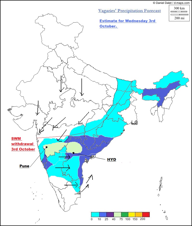
Rains in East Rajasthan, MP, Vidarbha and North AP remain moderate due to active monsoon axis.
Konkan light to moderate rains with stations averaging between 20-40 mms.  

Wednesday: As the rains diminish from Sindh, Northern regions of Pakistan including Punjab gets rain. 

Rains push into Northern states of Kashmir, HP, Punjab and Haryana.
Delhi NCR may get some rains from evening/night.
Vidarbha and North AP continue to get rains. Heavy showers possible for Hyderabad.
Konkan rains get weaker.

Thursday: Monsoon axis moves Northwards.

Rains in Punjab,Haryana, Delhi NCR and HP. 
Maharashtra will see isolated local rains in few places. No organised rainfall. 

Nepal gets increasing rainfall from Thursday. Kathmandu may see more rainfall frequency from Thursday.

Thus, we see increasing rains in Delhi NCR on Wednesday evening and Thursday.
Central India, i.e. East Rajasthan, MP, Vidarbha, North AP being along the monsoon axis continue to get rains of heavy to moderate intensity next 2 days.

Mumbai City:
Tuesday/Wednesday: Sunny warm intervals in the day. A few passing showers, in different parts. Day temp will be around 31c. Rain Amount: 10-15 mms.
Thursday: Warm day, with thunder clouds developing by evening. Showers in the evening will total up to 15-20 mms.

Pune: Tuesday/Wednesday/Thursday: Cloudy with light drizzles. Rainfall upto 7-10 mms /day.

Surat: Tuesday/Wednesday: cloudy with a few showers adding up to around 10-15 mms.
Thursday: Few showers, a couple of them may be heavy. Slightly more rainfall may be added on Thursday to 20 mms.


Very heavy rainfall figures of Sunday to Monday morning from Sindh (Pakistan):

Tangwani 372mm, Jacobabad 305mm, Kandhkot 282mm, Kashmore 280mm, Sukkur 164mm, Rohri 152mm, Khairpur Mirs 150mm, Kingri 80mm, Talhar 63mm, Kamber 65mm, Tanbobago 60mm, Larkan 58mm, Jhudo 53mm, Nara, Badin & Diplo 50mm each, KotDeji 45mm.

Abdasa (Kutch ) got 140 mms.

Saturday, September 08, 2012

Monday Update on Current Weather Page...BB6 moves Northwards into Pakistan..see Current weather Page for Latest @ 10.30am..
and GSB's Latest analysis on Inter Active Page..

Features of South West Monsoon Withdrawal and the advance of the North East Monsoon:

This note is not a forecast nor a quantum estimate. It is just how to begin a Monsoon Watch for the NEM.

In the very initail para, we begin with the basic fact of the Monsoon origins. SWM has its origin around the Mascarene Highs off Madagascar, and the NEM has its origin round a large anticyclone over Siberia.
However, coming to the advances of these systems, the mode of setting of the 2 monsoons differ. The onset of SWM is well defined, and follows progressively Northwards.This can be monitored quite accurately on weather charts.
On the other hand the onset of the NEM is not clearly defined. In fact, in some years, there has been no clear indication between the withdrawal of the SWM in peninsula India and the onset of the NEM.
I would, on the above point, normally hesitate to actually present or believe a "normal date" for the onset of the NEM in the Southern States.

Another point of comparison between the 2 monsoons is that, the NEM, during its life cycle, is normally with interrupted rainfall. The rainfall occurs in spells, accompanied by storng surge of cold air from the Siberain "origin". 
Many a times, these surges are associated with the formation of lows and systems in the Equatorial South China Seas. These systems move westwards. Occasionally, these systems intensify.

SWM generally has an un-interrupted rainfall in its four months tenure in some regions or the other.

Now, the commencement of the NEM , as stated above, is directly corelated to the withdrawal of the SWM. 
Hence, to start monitoring and "watching" the NEM, we must follow the withdarawl. 

Factors are to be considered while studying or monitoring the SWM withdrawal and NEM commencement. 

1. An anticyclone starts forming at sea level and 850 hpa level initially in Sindh and spreading to NW India. Originally, the seasonal low forms in May as a result of thermal highs, that is high temperatures. Now, we should observe and record the rate of (night) temperature drop, to see the diminishing of the low. A prelude to monsoon withdrawal.

2. The Monsoon axis starts moving Southwards, and for the NEM, rotates the wind directions. Both points, 1. and 2. are related and occur when the axis movement starts towards the South. For this, we have to monitor the wind change direction and dissolving of the "supporting" low in Sindh (Pakistan).

3. The ITCZ, simultaneously starts shifting Southwards. See Position of ITCZ in SWM(Diagram shows extreme break Monsoon Position) and in NEM (Winter).


4. An anticyclone moves towards central India at the 200 hpa level.  

5. Extreme High pressure initial formation starts in Lower Siberia regions. Now, like the Mascrene Highs are the "power House" of the SWM. the Siberian/Tibetan high is the "power house" of the NEM. Force winds rush from these highs towards the Bay and south China Seas in 2 seperate branches (Hadley Cell). Cooling of the region results in a good High formation.

6. Upper air stability visible observations to be seen. Cloud formations and clear (moisturless) skies are a strong indicator of the lack of monsoon atmosphere. For this actual observations and on-the-spot reports help. 

7. The SW cross equatorial winds weaken. Normally in a full SWM season, the depth of the SW winds coming into India. The reversal of wind fields occur at 6 kms.

8. Once these commence, we can start chasing the NEM... 

NEM: After actual setting, the general prevailing weather pattern should be stable like:

1.The Upper winds during the NEM across the Bay are in a clockwise direction. That is an anti-cyclone is formed. At a level of 500 mb, the centre of the anticyclone shifts to central Burma region.Another factor are the jet streams. 
In the SWM, the Tropical Easterly Jet stream dominates the Peninsula, while the Sub-tropical Westerly Jet Stream is the feature of the NEM.

2.The normal Sea Level Pressure during the NEM is a large system of low pressure over the Central Bay. It can extend into the Indian Peninsula as a trough.Towards the end of November, there is a shift southwards of this extended low.

3.The general variations and fluctuations in intensity of this low pressure, governs the rainfall. When the trough is well defined, and the low is well marked, rainfall over the southern peninsula is good. Most of the NEM rains depend on depressions and cyclones from the Bay towards the East Coast of India. This is more so in the coastal Districts.The highest seasonal rainfall (October-December)of around 75 cms occurs along the SE coast of Tamil Nadu and adjoining South AP.

4.During the NEM, an occasional burst of cold air from the Siberian High develops a low pressure sysytems over the Equatorial regions of the South China Seas. These systems move slowly westwards thru Sarawak/Eastern Malaysia coast, and remnants of these cross 
over into the Bay and form depressions

.

This brief note is not to be used for commercial purposes.


Saturday Evening: Actually its quite confusing. Several charts show the UAC prevailing over the South Saurashtra region at 700 hpa. In fact, the NMCC chart shows it as a strong system.

Certain charts show the UAC as merged with BB6.

My take is: BB6 now lies over South Rajasthan and adjoining Kutch at 1000 mb. 
The UAC also prevails over the Arabian Sea Kutch/Sindh coastline. that too moderately strong.(Was expecting it to weaken ,but is quite stubborn).

Our (forecasted)Sunday UAC is getting organised in the Bay and is in the nascent stage.
Flash (6.40pm): BB6 has tracked due west last 1 hr. Good precipitation (Thunderstorms) for Lower Sindh and KHI soon.

Thursday, September 06, 2012

Friday Evening
BB6 tracks a bit NW and is over West Rajasthan. 
UAC off South Gujarat coast moves west, and is off the SE Sindh coast. Rain likely in Karachi tonite again as a result.

Thursday Evening:
 BB6 now over West MP, can show a possibility of moving in a NW track.Axis considerably South along North Gujarat/thru low and westwards into the bay. 

A similar axis runs aloft at 850 hpa (Thai Met). Observe the UAC over Thailand. It has moved west last 24 hrs. 

Friday 7th: 
Rainfall will be heavy in North Gujarat and South Rajasthan. Decreasing rains in North Maharashtra, Vidharbha and Marathwada.
North Konkan will get moderate rainfall, and light rains in South Konkan.
UAC over the Arabian Sea off the Sindh coast weakens after Friday. Moderate rains along adjoining Sindh coast and Upper Sindh regions also on Friday. Karachi gets some showers on Friday. 
Rainfall in Nagpur decreases considerably.

Saturday 8th: 
BB6 weakens and moves NW. More rains in Rajasthan and adjoining Sindh. 
Heavy rains in North Rajasthan, Haryana.Coastal AP and Orissa can get heavy rains. Vizag may get afternoon showers. Decrease for Maharashtra rains.
The east coast off shore trough gats aligned, which could bring showers to Eastern TN and AP on Saturday.

Pakistan Punjab also can get heavy rains on Saturday. Multan and region around can get heavy rains. Rains weak in Southern Sindh.

Sunday 9th: 
An UAC or a low may form in the Bay. East coast trough may strengthen. 
Heavy rains in Punjab and Haryana. Moderate in North Rajasthan. 
Good rains along Coastal AP and TN... Konkan rains weaken.
adjoining Pakistan also gets heavy rain on Sunday.

Nepal: With no clear system over Nepal, next 3 days will see localised Thunderstorms in the country. However, there can be some increase in rains in the western regions on Saturday.
Neeraj informs us that Nepal is still deficient in rains.
Kathmandu: Friday/Saturday/Sunday: Days will be cloudy at 29c. Evening thundershowers possible, with rain amounts being 10 mms.Total rain in September till date 44 mms.

City Forecasts:
Mumbai:
Friday 7th: Partly cloudy with 3/4 showers. Showers in some regions may be heavy and abrupt. Day may get warmer. Rain Amount: 15-20 mms.

Saturday 8th: Partly sunny with a few passing showers, varying indifferent parts. Rain Amount: 10-15 mms.

Sunday 9th: Partly sunny and hot day, with thunder clouds developing by evening. Few showers in some parts. Rain Amount: Upto 10 mms.

Pune:
 Friday/Saturday/Sunday: Warm days. Sunny with some clouds developing by evening. Light evening rain in some parts. 

Delhi NCR: 
Friday: Warm day with not much precipitation.

Saturday: Day starts getting cloudy gradually by evening. Distant lightning possible with showers in some parts.

Sunday: cloudy with heavy showers in many parts. Rainfall increasing on Sunday. Around 25 mms (avg). 

Chennai:
Friday: Partly cloudy. Humid and stuffy at night.

Saturday: Could see some eveing showers in some parts.

Sunday: Cloudy with increasing rains. Showers by evening in almost all areas. Rains may amount to 30 mms.

Hyderabad (India): No meaningfull rains in city next 3 days.

Pakistan:
Karachi sees rainfall decreasing after Friday, with no meningfull rains weekend.
Hyderabad (Pakistan): Cooler days on Saturday /Sunday. Increase in rainfall on Sunday. Sunday will see rainfall upto around 20 mms.
Sukkur: rains possible on Sunday.

Forecasted East rough  Let's look into the 3rd week of March ( 17th - 21st). Mumbai : Hot weather likely for Mumbai region this week, ty...