Monday, November 30, 2009


This blog will now have the privilege of being directly available to U.K. weather enthusiasts, thanks to Mark Vogan from Scotland, expert in meteorology. With this "collaboration", we can interact better and share weather events from both sides. "Vagaries of the Weather" will also put up a direct link to Vogan's blog.


For European readers, the weather pattern in the Indian Sub-continent has basically 3 seasons: Winter, Summer and the Monsoon rainy season. Officially, the Monsoon season ends on 30th September, when Winter commences. The entire Indian region can be roughly divided into 3 zones, northern, central and southern. Winter season starts from the northernmost regions.

Summer starts in the Indian region from March, the heat shifting gradually northwards.

However, the northern and southern regions are the 2 areas which get winter rains. Both from completely different systems. We will discuss these as and when systems develop.


South:

IMD states that weak north-east monsoon conditions are likely to continue over south peninsular India during the next 36 hours

However, some international models predict the formation of a low-pressure area over southeast Bay of Bengal with a westward movement.

NGP/GFS model also predict upper air circulations showed near the southwest Bay and the system moving southwards, even below Sri Lanka.

Subsequently, a slight increase in rainfall activity thereafter, could be the commencement of a wet regime over the southern peninsula during the first week of December according to forecasts by NCEP.

With COLA showing an increament of rains along the Tamil NAdu coast from the week begining 7th. December, the southern peninsular surely is in for some revival of monsoon rains soon! I see, some heavy rain along the T.N. coast mainly on Tuesday.

North:

For the northern sub-continent, its been dry (due to no Western disturbances at present), and cooling down to some extent. The lowest of the temperatures in India, naturally has been in the extreme northern district of Ladakh, with Darbuk at -21c. In the northern state of Himachal Pradesh, the lowest was -5c recorded at Keylong. (Far better than -12c, a few days ago).

But overall, in the central and rest of the regions, the lows are almost near the normal levels.(IMD map).


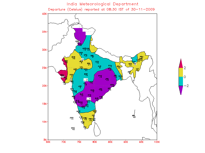
A map of the day's highs show the clear demarkation of temperatures in the nort, Central and southern regions.


Mumbai: Clear weather throughout the week. Days will remain around the 31/32c mark, and the low, during the week,will move towards the 18-20c range from the current 21c.


kapadias@gmail.com

Friday, November 27, 2009


Heavy November Rains in U.K.

Though a bit late, putting up this information about the record rains in Scotland is a must.


The wettest November day on record in the U.K. has caused flooding problems across the south west of Scotland.


Heavy rain affected many parts of north-west Britain during 18, 19 and 20 November 2009, and led to widespread flooding.


The rain was particularly heavy and "monsoonish" (says Mark Vogan) in the mountainous terrain of Cumbria and southwest Scotland resulting in record rainfall totals.


In Cumbria, 372.4 mm of rain fell at Seathwaite and 361.4 mm of rain at Honister between 0800 on Wednesday 18 November and 0400 on Friday 20 November. This includes the 24-hour total at Seathwaite (ending 0045 on Friday 20 November) of 314.4 mm, which is a UK record for a single location in any given 24-hour period


Parts of Scotland were also badly affected, and flooding was also reported in Dumfries and Galloway in Scotland, where 30 roads closed in "treacherous" conditions.


"It's desperate. The town centre is completely flooded, the only people out there at the moment are the emergency services. The water is up to the waists of the firefighters." - A resident owner of a hotel.


About 1,200 homes in the Cockermouth area and 349 around Keswick lost power on Thursday night.


Further, there is excellent information in detail about this topic and rain records, and generally very good details of U.K. weather on Mark Vogan's blog.

kapadias@gmail.com

Monday, November 23, 2009

Pictorial Blog :


Today's Weather , 23rd. Nov.
Minimum Temperature Departure from normal
Maximum Temperature Today:
Today's Pressure Map:


Last week's Temperature Anolomy:

Last Week's Rainfall:
MJO Prediction:


Blue shows negative OLR anolomies, hence enhanced convection. Yellow shows positive and supressed convection.


Friday, November 20, 2009

North-East Monsoon Review:

About a month of the actual the northeast monsoon has generated excess rainfall in most of the southern peninsular states during the season so far . The best reciepient is North Interior Karnataka, with an excess upto +89%, and coastal Karnataka with a surplus of +72%. TamilNadu showed a surplus of +15%, though there are some regions in the north still deficient. (Map). So, with Kerala at +8%, it is overall a good season for the south as yet. Of-course with the Nilgiris getting much in excess of damaging rains.

The season has been normal or above normal over the southern peninsula.

But the central regions of Mah. and M.P. and more than their share of this "unseasonal" rain. Map shows all this region in excess.

Now, as per international forecasts, more rains are coming to the Tamil Nadu coast during November 19 to 26.

The south bay will host weather systems like lows/easterly waves for the southern peninsula during this time frame.

Hence Tamil Nadu coastal regions could expect heavy rains from the 21st.

Also, COLA sees some rain along the western coast (Karnataka coast) from 23rd. Some of this rain belt is seen creeping into southern Maharashtra on the 24th. November. Hence, we can expect some light rain in southern Maharashtra. Lets say Pune can recieve cloudy weather/light rain on 24th.

Mumbai: Weekend will be dry. No surprise after enough rains. In November, Mumbai Colaba has recieved 120mms (Record 164mms), and S,cruz has got 78 mms (Record 101 mms). With some reduction in humidity, one may feel a bit comfortable, though I expect the days to be high at 33c. Night will be pleasant at 22c.

Pune too was not too far from its record November rains. The city recieved 176 mms this month against the record of 209 mms. A drop in the night temperature is expected for Pune, low could nippy at 12/13c for the weekend. But increasing cloudiness after Monday will arrest the nip.

Wednesday, November 18, 2009

Two Very Interesting Weather Related Stories: (Reproduced from Earthweek).

Unusually early and heavy snowfall over Beijing attributed to China’s ongoing weather modification projects has caused Beijing residents to question whether it’s right to mess with mother nature.

The earliest snowfall to blanket Beijing in 22 years fell on November 1. It was followed 10 days later by another period of frozen precipitation, accompanied by freak thunder and lightning.

Artificial methods have been used for several years to mitigate drought effects across North China. They were also recently used to prevent rainfall during the 60th anniversary celebrations of the Communist revolution.

But such heavy and frequent snow so early in winter has snarled traffic and forced the capital's international airport to halt operations. The resulting inconvenience has triggered complaints from the public, according to the newspaper.

Xiao Gang, a professor in the Institute of Atmospheric Physics at the Chinese Academy of Sciences, told the paper: "We should not depend too much on artificial measures to get rain or snow, because there are too many uncertainties up in the sky."


Arctic Winter Refreeze Was Near October Record Low

Warm Siberian winds caused October 2009 to have the second-lowest ice extent for the month over the 1979 to 2009 period. Warm southerly winds during October warmed the Arctic so much that they prevented sea ice from reforming at a rate typical of the previous 30 years.

The U.S. National Snow and Ice Data Center reports that October had the second-lowest ice extent for the month over the period from 1979 to 2009.

The formation of polar ice normally accelerates during that month as the sun sinks lower in the southern sky each day and the day-long nights of winter return above the Arctic Circle.

But the growth rate slowed for a while early in the month as strong winds from the south blew over central Siberia, preventing the ice from forming along the coast there.

By month’s end, expansive areas of open water regions still existed in the northernmost North Atlantic and north of Alaska.

Monday, November 16, 2009

Arabian Sea active again ?

The low pressure area over Commorin area and neighbourhood now lies over Commorin-Lakshadweep area.
A trough in mid & upper tropospheric westerlies now runs roughly along Long. 72° E to the north of Lat. 20° N.
On Sunday, a vortex formation was observed in the south Konkan region ,and another in the Goa/Coastal Karnataka region. Both inland. (IMD Map)

As a result of the above, we have reports of heavy rainfall in the extreme south peninsular and all along the west coast. Some heavy, and unusual rain figures for the 24 hrs. ended 15th. are :Gingee (Villupuram dt) 18, Orathanadu (Thanjavur dt) and Kanyakumari 17 each (10.6 again on Monday), Adirampattinam 10.8, Thiruvanthapuram 10.4, Thanjavur 9.9, Kottayam 8.6,Panjim (Goa) 5.0, Kaveli 4.9, Cannur 4.3, Agumbe & Mumbai (Colaba) 3.9 each.
Also, some more complicated interactions like this upper air tropospheric trough interactiing with the induced low of the W.D. and bringing in moisture from the Arabian Sea has brought rain along the west coast and into Maharashtra in the last 2 days.
The prevailing systems will move away north-eastwards, and bring clearer and colder weather to the north-west and north by Monday, thereafter bringing low temperatures.
Mumbai( Colaba) got very heavy thundershowers in the early hours of Sunday, and recorded 39 mms in a 2 hour rain period. Pune got a heavy thunderstorm on Sunday afternoon with 37 mms and Mahableshwar recieved 60 mms on Sunday
Now, what about this new low ? International models predict the low could either move up to the Karnataka coast, or westward from Lakshadweep away from India’s coast. 2 obvious directions !!
One more day of cloudy and light rain conditions for Mumbai on Monday. Rainy conditions will clear from Tuesday onwards. ( for the time being??).

An easterly wave seems to be on stream to renew the rain periods for the south from 18th. resulting in very to heavy rains over Sri Lanka, southeast Tamil Nadu and south Kerala. ECMWF too predicts an easterly wave with another ‘low’ just east of Sri Lanka by 20th.


Thursday, November 12, 2009

Cold days in Central India

Phyan continued moving northward to north-northeastward over land and should now fizzle out within the next 12 due to further land interaction and strong vertical wind shear.

Vertical wind shear, is the sudden increase in wind speeds with height. This blows off the topmost region clouds of the storm head and kills the system.And also interaction with land cuts off the moisture needed to feed the cyclonic system.

Now, this has spread residual moisture that Cyclone Phyan has spread out over mainland, resulting in light rains and very cold days in central India and Rajasthan. Places were upto 14c below normal today.
Remaining moisture may create rain bearing clouds in the regions of interior Maharashtra, M.P. and west U.P. in the next 2 days. And precipitate some rain as well.

For the weekend:
North: Dry and day and nights getting colder. Nights 2/3 c below normal.
Central/West: Sparse rain and cloudy. Rain in pockets.
South: Spresd out rain in almost all the regions of the south. But not extreme heavy.
Mumbai: Weekend, partly cloudy. Coolish temperatures. Some rain on weekend, maybe towards Sunday.

Wednesday, November 11, 2009

Cyclone "Phyan"
Having moved at "super speed", much faster than a normal cyclone would, it has crossed the coast south of Mumbai, and now, at 5p.m. is at 19N and 73E. Core pressure is 989 mb and winds at 40 knts. That is East of Mumbai. The rainfall concentration is now to the East of Mumbai.

Mumbai: Rather than a hindrance, the rains were welcome in Mumbai, and surely to the lakes supplying water. A few heavy showers could still be expected in evening, tapering off late in the night. Rains to some extent, maybe light, till tomorrow afternoon at the most.

Heavy rains in the Nilgiris:

Ketti, in the Nilgiris, near Ooty, had an unusually heavy rainfall of 82 cms in the 24 hrs. ended Tuesday morning. Coonoor had a super 35 cms for 2 consecutive days on Monday and Tuesday, while Ooty recorded 18 cms. And a low temperature of 5c ! Kodaikanal recieved 15 cms also on 2 consecutive days from Monday. Wow ! No wonder the massive landslides there !


Cyclone "Phyan" update:
Latest position of "PHYAN" as on noon ,
Max wind speed at 55kts, core presuure at 982mb, and position at -172N-731E.
Could cross the coast south of Mumbai this afternoon, and start weakening.
CYCLONE "PHYAN"

TROPICAL CYCLONE (TC) 04A, "PHYAN" IS NOW LOCATED APPROXIMATELY 150 NM SOUTH OF
MUMBAI, INDIA, AND HAS TRACKED NORTHEASTWARD OVER
THE PAST SIX HOURS. THE FORECAST FOR CYCLONE CROSSING THE COAST HAS SHIFTED TO THE SOUTH, RESULTANT OF
RECENT NORTHEASTWARD MOVEMENT.

THE SYSTEM HAS WINDS HAVE INTENSIFIED TO 50 KNOTS, AND WITH CORE PRESSURE OF 985mb,"EYE" FORMATION IS BECOMING IMMINENT.
OVERALL FORECAST INDICATES FOR LANDFALL NEAR MUMBAI, AROUND 100KMS NORTH/SOUTH, AROUND AFTERNOON TODAY, THEN MOVING
NORTH-NORTHEASTWARD AND FURTHER INLAND.

MUMBAI IS GETTING MODERATE RAIN SINCE YESTERDAY. WITH THE DAY PROGRESSING ON WEDNESSDAY, THE RAINFALL WILL INCREASE, AND STORMY WAVES EXPECTED ON THE COASTLINE WEDNESSDAY EVENING. HEAVY RAINFALL OVER 100mms EXPECTED IN MUMBAI.

PUNE/NASIK ARE EXPECTED TO GET HEAVY RAINS ON WEDNESSDAY, AND REGIONS OF MADHYA MAHARASHTRA WILL RECIEVE VERY HEAVY RAINS.

COASTAL MAHARASHTRA AND SOUTH GUJARAT COAST WILL BEAR THE MAIN BRUNT ON WEDNESSDAY/THURSDAY.

next posting "soon"
kapadias@gmail.com

Tuesday, November 10, 2009

Cyclone 04A.
The US Joint Typhoon Warning Centre (JTWC) has upgraded the Arabian Sea weather system to a cyclone, 04A, onTuesday, with estimated wind speeds ranging upto 35 knots and 45 Knots in gusts.
At 70.9E and 14.1N, it is approximately 340 NM southwest of Mumbai. Expected track, north/north-east.
Posted on Tuesday @ 12 noon.
kapadias@gmail.com


Monday, November 09, 2009

Unseasonal Rains have commenced in Maharashtra.

Nasik district bore the brunt of a hailstorm on Monday, and several regions of Aurangabad, Kolhapur and solapur, and Marathwada have had rains.

The system in the Arabian Sea is now of depression dimesion.

However, some international models differ, and forecast the depression may move north along the west coast to take a westward turn off the north Konkan coast into the sea.

Some international forecast models indicate the Arabian Sea weather system may track north-northwest, presumably due to a western disturbance, now moving across Northern India, and its secondary low possibly dipping low into the Arabian Sea in a day or two.

The IMD outlook is in agreement with most international models This depression, is expected to cross in Gujarat during the next two days, the IMD said.

While COLA is of the view that the system may cross the Konkan coast and precipitate rain inland into Maharashtra and southern M.P..

In short, we have a depression moving up the west coast of india from the 9th. and precipitating rain along the Kerala/ Karnatakacoast on the 9th./10th., thence along Goa and south Konkan, and interior Maharashtra on the 10th/11th. and North Konkan will have moderate rains, with some heavy falls on the 10th/11th.

I personally feel the depression will fizzle out in the sea itself by the 12th. After some unseasoanal rains along its path as mentioned above. Let's watch its movement from day to day and see the changes.

Mumbai: Same forecast as per last blog holds good.
Stuffy weather with light showers on Tuesday, and some showers, with winds on Wednessday.Winds will change direction from easterlies to southerlies to westerlies, as per the depresiion movement. Maybe some thunder in the night. Day temperatures will be around 31c. Cloudiness decreasing from Thursday evening, as the depresion moves away from Mumbai.

Friday, November 06, 2009

Unseasonal Rains in Maharashtra?

The IMD confirms on Thursday that a cyclonic circulation has formed over the Comorin area. A trough from this system runs thru extreme south peninsula.

The latest from several models show that the low off Lanka coast would move north up the Indian coastline, and itensify a bit on November 8 and 9, and then merging into cooler waters off coastal Karnataka and getting stuck before weakening.

The system then may curve over land into Maharashtra around November 10th.COLA/ NCEP predict along similar lines.

As a result, Mumbai forecast for rain on Monday/Tuesday/Wednessday holds good. Rainfall upto 25mms could be expected on these 3 days in Mumbai.

But a little more is in store for the rest of Maharashtra. The interiors of the state can expect rains from Tuesday, and some places in Pune/Solapur and the other districts of madhya maharastra can get 40-50 mms in these 3 days.

Under the influence of the existing low, another low pressure is likely to form with a trough extending to southwest Bay of Bengal in the next two days.

Most international models predict good more rains over the peninsula over the next week, with likelyhood of continuing precipitation over south peninsular right until November 20.

Thursday, November 05, 2009

Low in South Arabian Sea

Streamline map from IMD today indicates the initial formation of a low in the south Arabian Sea.

Now, many models show this moving northwards into the Arabian Sea, but, stopping short at 15N, off Goa. Finally, as I mentioned, it may fizzle out due to the passing of an upper air W.D. in the northern plains of the sub-continent.
The CMC and ECMWF both models confirm the system upto off the Goa coast around the 9th.
Moderate rains are likely in all the regions of the southern peninsula due to the "pull" from the north-east by the system. Heavy rains can start in kerala on the weekend.
Approaching W.D. can precipitate rains in the northern plains and snow in the hills on the weekend. Hence initial increase in night temperatures, but to fall next week

Mumbai: Skies getting partly cloudy from Saturday. Rise in night temperatures from the present 23c to 25c. As of now, light rain may be possible on Monday.

Tuesday, November 03, 2009

Approaching W.D. may counter Arabian Sea system:

The trough of lower pressure running from the Arabian Sea thru peninsula into the southwest Bay has shifted into the Comorin area on Monday. ( Thai Map enclosed)
The FNMOC has also kept under watch thedevelopment in the southeast Arabian Sea around the Comorin area. At present, it is short of being officially being a low-pressure area. Its present wind speed is 15Knots/hr.

It is shown as 92B in the NRL site and this is forecasted to become a ‘low’ by the ECMWF, which will move northwards along the west coast of India, and, as per international forecasts, it will fizzle out somewhere around 15N, due to non support from the sea water temperatures.
I feel it may intensify a bit, creating cloudiness in the Arabian Sea, and, after the 4th. of November, bring some unseasonal rains along the coasts of Kerala, Karnataka and Goa. Rains along these regions may last a couple of days.
But I would wait and watch to forecast precipitation alomg the Konkan regions. Because, by this time, an active W.D. coming along would dominate this southerly system, and not allow it to "grow" further.
Also, another system within the same trough in the bay, would be required to share the available moisture along the trough line.
The north-east monsoon will till then continue to remain "feeble" and in a "low gear", in the T.N. and interior Karnataka areas.


An approaching W.D. is now keeping the temperatures high in the northern regions of the sub-continent.
Days in the western regions were very hot on Monday, with Chorr (Pakistan) at 38c, and Rajkot and Veraval also at 38c. Mumbai was at 36.6c ! ( IMD map shows the heat clearly).
With the W.D. we can expect a reasonably good drop in the temperatures,starting from the nortwestern areas, and more effectively in the night temperatures from this weekend. Also, rains could be expected in the plains of northern India and lower and middle hills from 4th. for a couple of days. And ofcourse snow in the upper hills.


Forecasted East rough  Let's look into the 3rd week of March ( 17th - 21st). Mumbai : Hot weather likely for Mumbai region this week, ty...